
 Leaf-miner: CAT L – The leaf or a Photo required –
  Larval Case: C1 – Distinctive Species –
  – click for General Verification Guidelines | – click for Specific Verification Guidelines
  – Generally Common / Widespread
  – Leaf-miner
Confusion Species: other Cnephasia
Mine Period Additional: Considered a Leaf miner as the larvae initially mine the leaves of its host plants. Then later spinning the leaves or flowers together for pupation.
Mine ID Difficulty: Not Recorded
Mine Type/s: Not Recorded
Mine Feeding Method/s: Not Recorded
Mine Comment: None.
Blue-coded] moths is not displayed/updated in this tab. However, all verified records for this moth are listed in the RECORDS tab below. 


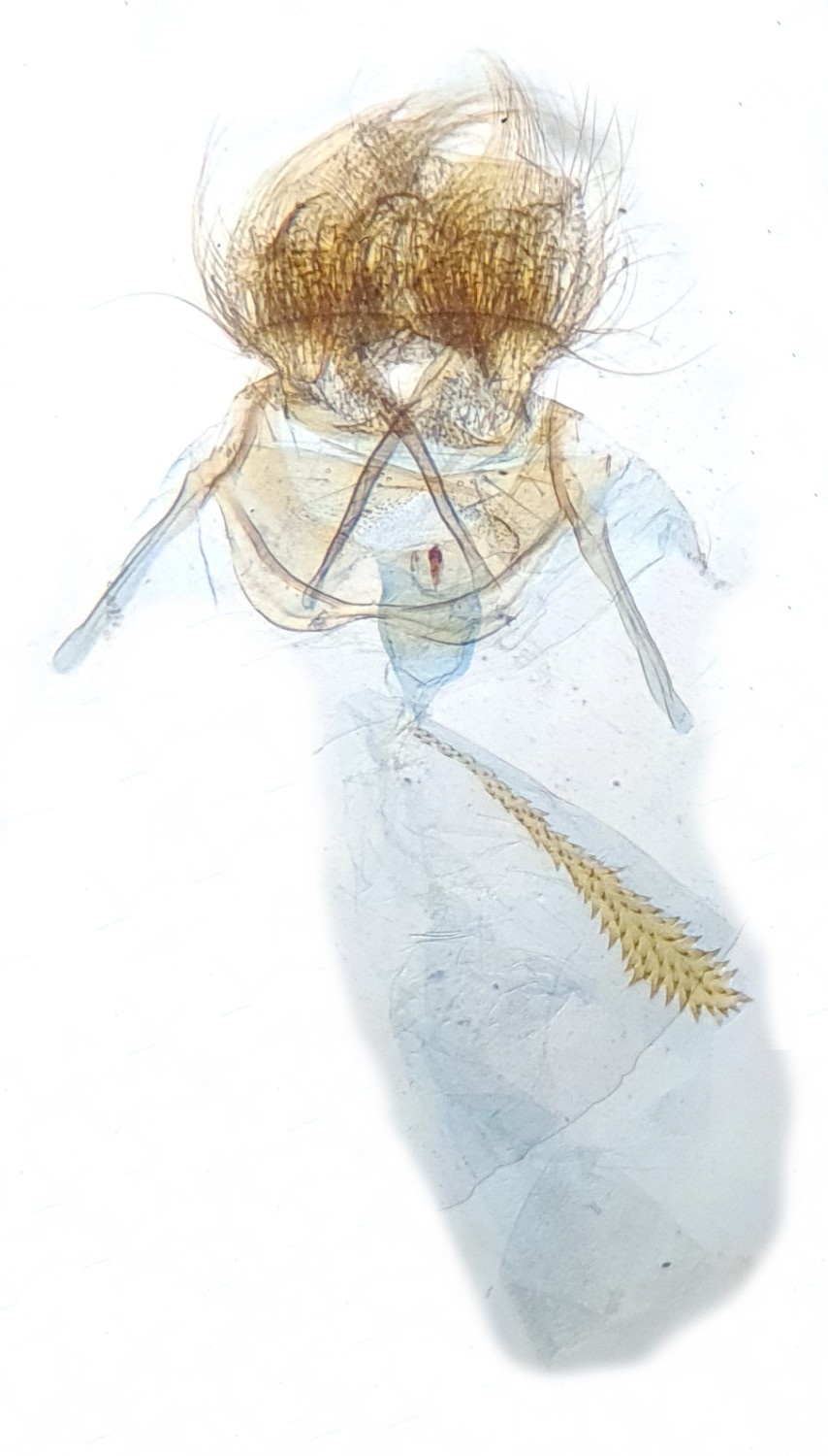
Image Gallery
No gallery images found for this moth.
Temporal Distribution Chart
Adults: (between 1997 - 2025)
Distribution Map for Cnephasia asseclana
↳ from 2026+
↳ 4 from 2020 - 2025
↳ 15 from Before 2020
If the Map Layers function fails, just refresh the page and it should be OK after. Use the +- zoom on the top left, or on a tablet, use two fingers to zoom. Remember, the last layer you ticked is the one which displays the popup information - they sit on top of each other - de-select then re-select, to see the popup values.
Bedrock Geology ** indirectly affects moth distribution by influencing the type of habitat and food plants available in an area. In turn, this may affect the types of moths that can thrive, or where they can most likely be found.
NBN Atlas UK Distribution for – Cnephasia asseclana
⚠️ Please wait for the map to load fully – do not click the link shown.
Note – the NBN Atlas datasets are listed in the map below and vary in their currency (uptodateness) – however,
the map does give a general indication of the moth's distribution across the UK.
Monthly Records By Year:
Cnephasia asseclana
( data includes both Larvae and Adult Stages )
Monthly Counts By Year:
Cnephasia asseclana
( data is based on 'Adult' stage records only )
First/Last Recorded Dates: Cnephasia asseclana
Adult-only & Anything [Larvae, Pupae, Adult, Mines]
Shading shows moth presence between dates
Click the colour discs below to Select/De-select as Required
Recordings By Year: Cnephasia asseclana
( All data includes both Larvae and Adult Stages )
Annual Growth Rate (AGR): Cnephasia asseclana
AGR: 0% | Total % Change: 0%
Hectad (10kmx10km) Coverage: Cnephasia asseclana
( data includes both Larvae and Adult Stages )
Flight Periods – Indicative –vs– Recorded Data
Cnephasia asseclana
Cnephasia asseclana
Flight Period chart – the grey hatched area above, which can cross one or more months, pictorially represents the best guess we have for this moth's flight periods [month/s]. The coloured lines represent the actual months seen in flight, from site observation records received between 2020-2026.
Mine Periods – Indicative –vs– Recorded Data
Cnephasia asseclana
Cnephasia asseclana
( data includes both Larvae and Adult Stages )
Mine Period chart – the grey hatched area above, which can cross one or more months, pictorially represents the best guess we have for this moth's mine periods [month/s]. The coloured lines represent the actual months seen mining, from site observation records received between 2020-2026.
Records Behind the Map and Charts - Cnephasia asseclana – 19 records available
Listed by Year - descending - scroll across to see all table columns
| Site Name | Tetrad | Date | Count | Stage | Recorder | Source | RecordKey |
|---|---|---|---|---|---|---|---|
| Shaw Farm, New Mills VC | SJ98Y | 12/08/2025 | 1 | adult | Hind, Steve | vc57_irecords_extract | iBRC44526617 |
| Ingleby Ave, Derby | SK33L | 20/06/2025 | 1 | adult | Shervill, Andrew | vc57_irecords_extract | iBRC42536159 |
| Hathersage, Derbyshire, UK | SK28F | 07/06/2022 | 1 | adult | Miles, Claire | vc57_irecords_extract | iBRC29213188 |
| Grange Wood, Overseal | SK21S | 02/07/2021 | 1 | adult | Graham Finch | vc57_irecords_extract | iBRC46107207 |
| Midway Rd,Midway,Swadlincote | SK32A | 13/07/2013 | 1 | Adult | M.J. Williams | vc57_danes_bc_data | LC000334001CP905 |
| Rosliston (National Forest Centre), Swadlincote | SK21N | 20/07/2012 | 6 | Adult | BUDWORTH, Mr D., CLARKE, Mr D.A., WARD, Mr N.J., S | vc57_danes_bc_data | LC000334001CP0DC |
| Bamford St,Ripley | SK34Z | 15/07/2012 | 1 | Adult | Thorpe, Steve | vc57_danes_bc_data | LC000334001COY6K |
| Bamford St,Ripley | SK34Z | 19/06/2012 | 1 | Adult | Thorpe, Steve | vc57_danes_bc_data | LC000334001COU9L |
| Bamford St,Ripley | SK34Z | 17/06/2012 | 1 | Adult | Thorpe, Steve | vc57_danes_bc_data | LC000334001CP7SP |
| Denefields,Matlock | SK36A | 22/07/2010 | 1 | Adult | Dave Budworth;N.J. Ward | vc57_danes_bc_data | LC000334001COX9U |
| Newboundmill Lane,Pleasley | SK56C | 13/06/2009 | 1 | Adult | B. Elliott;C. Stubbs | vc57_danes_bc_data | LC000334001COSQF |
| Drakelow NR (car park),Burton on Trent | SK22F | 12/07/2008 | 1 | Adult | M.J. Williams;R. Williams | vc57_danes_bc_data | LC000334001COSJP |
| Drakelow NR (car park),Burton on Trent | SK22F | 28/06/2008 | 1 | Adult | M.J. Williams;R. Williams | vc57_danes_bc_data | LC000334001CP49D |
| Carvers Rocks,Hartshorne,Swadlincote (old toilet block area) | SK32G | 11/08/2007 | 6 | Adult | A. Davison;K. Peach;N. Topliss | vc57_danes_bc_data | LC000334001COWFI |
| Main St,Kings Newton,Melbourne | SK32Y | 13/07/2005 | 1 | Adult | Soar, Will | vc57_danes_bc_data | LC000334001COVUA |
| Foremark Resr, Ticknall | SK32H | 09/07/2005 | 6 | Adult | A. Davison;N. Topliss;W. Soar | vc57_danes_bc_data | LC000334001CP2MD |
| Shipley Park (Cinder Hill), Shipley, Ilkeston | SK44H | 02/07/2005 | 1 | Adult | Dave Budworth;B.G. Sewell;T. Duro | vc57_danes_bc_data | LC000334001COVTN |
| Edgecote Drive,Newhall,Swadlincote | SK22V | 03/07/2004 | 1 | Adult | Topliss, Neil | vc57_danes_bc_data | LC000334001CP1VG |
| Dowey Lumb NR, Dronfield | SK38Q | 25/07/1997 | 1 | Adult | H.E. Beaumont;R.F. Botterill | vc57_danes_bc_data | LC000334001COQXW |