

 – click for Adult Macro Verification Guidelines
 – Rare / Uncommon / Scarce
  – Day-flying
Comes readily to Pheromone Lure
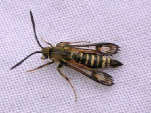


Image Gallery

Temporal Distribution Chart
Adults: (between 1990 - 2026)
Distribution Map for Bembecia ichneumoniformis
↳ 9 from 2026+
↳ 59 from 2020 - 2025
↳ 24 from Before 2020
If the Map Layers function fails, just refresh the page and it should be OK after. Use the +- zoom on the top left, or on a tablet, use two fingers to zoom. Remember, the last layer you ticked is the one which displays the popup information - they sit on top of each other - de-select then re-select, to see the popup values.
Bedrock Geology ** indirectly affects moth distribution by influencing the type of habitat and food plants available in an area. In turn, this may affect the types of moths that can thrive, or where they can most likely be found.
NBN Atlas UK Distribution for – Bembecia ichneumoniformis
⚠️ Please wait for the map to load fully – do not click the link shown.
Note – the NBN Atlas datasets are listed in the map below and vary in their currency (uptodateness) – however,
the map does give a general indication of the moth's distribution across the UK.
Monthly Records By Year:
Bembecia ichneumoniformis
( data includes both Larvae and Adult Stages )
Monthly Counts By Year:
Bembecia ichneumoniformis
( data is based on 'Adult' stage records only )
First/Last Recorded Dates: Bembecia ichneumoniformis
Adult-only & Anything [Larvae, Pupae, Adult, Mines]
Shading shows moth presence between dates
Click the colour discs below to Select/De-select as Required
Recordings By Year: Bembecia ichneumoniformis
( All data includes both Larvae and Adult Stages )
Annual Growth Rate (AGR): Bembecia ichneumoniformis
AGR: -3.56% | Total % Change: -59.6%
Hectad (10kmx10km) Coverage: Bembecia ichneumoniformis
( data includes both Larvae and Adult Stages )
Flight Periods – Indicative –vs– Recorded Data
Bembecia ichneumoniformis
Bembecia ichneumoniformis
Flight Period chart – the grey hatched area above, which can cross one or more months, pictorially represents the best guess we have for this moth's flight periods [month/s]. The coloured lines represent the actual months seen in flight, from site observation records received between 2020-2026.
Records Behind the Map and Charts - Bembecia ichneumoniformis – 92 records available
Listed by Year - descending - scroll across to see all table columns
| Site Name | Tetrad | Date | Count | Stage | Recorder | Source | RecordKey |
|---|---|---|---|---|---|---|---|
| Breadsall Greenway | SK33Z | 22/06/2026 | 2 | adult | Roome, Martin | vc57_irecords_extract | iBRC54131261 |
| Gleadless Valley LNR | SK38L | 19/06/2026 | 4 | adult | Mella, Pete | vc57_irecords_extract | iBRC53773496 |
| Gang Mine, Cromford | SK25X | 16/06/2026 | 2 | adult | Ashton, Clive | vc57_irecords_extract | iBRC53685908 |
| Markham Vale Derbyshire | SK47K | 15/06/2026 | 19 | adult | Morris, Sid | vc57_irecords_extract | iBRC53673344 |
| Ambaston Gravel Pits | SK43F | 09/06/2026 | 3 | adult | Roome, Martin | vc57_irecords_extract | iBRC54127160 |
| Markham Vale complex | SK47L | 09/06/2026 | 19 | adult | Radford, Mark | vc57_irecords_extract | iBRC53287240 |
| Seymour MVN | SK47L | 08/06/2026 | 1 | adult | Radford, Mark | vc57_irecords_extract | iBRC53243643 |
| Arkwright Pit | SK47F | 29/05/2026 | 6 | adult | Radford, Mark | vc57_irecords_extract | iBRC52771062 |
| Markham Vale | SK47L | 22/05/2026 | 1 | mine (tenant | Penson, Melanie | vc57_irecords_extract | iBRC52533592 |
| Waterswallow's Quarry, Buxton | SK07X | 13/07/2025 | 1 | Adult | Orridge, Steve | vc57_irecords_extract | iBRC50032175 |
| Calver Sough, Derbyshire, UK | SK27H | 08/07/2025 | 1 | Adult | Rob Foster | vc57_irecords_extract | iBRC43172905 |
| Land near Newfield School | SK38L | 20/06/2025 | 2 | Adult | Mella, Pete | vc57_irecords_extract | iBRC42467305 |
| Gang Mine, Cromford | SK25X | 17/06/2025 | 1 | Adult | Ashton, Clive | vc57_irecords_extract | iBRC42378850 |
| Pleasley Pit Country Park | SK46X | 13/07/2024 | 1 | Adult | Whiteley, Derek | vc57_irecords_extract | iBRC37375113 |
| Pleasley Pit Country Park | SK46X | 13/07/2024 | 1 | Adult | D Whiteley @ Sorby NHS Outing | vc57_irecords_extract | iBRC39702537 |
| Pleasley Pit Country Park | SK46X | 13/07/2024 | 1 | Adult | Hewitt, Jane | vc57_irecords_extract | iBRC39762870 |
| Glapwell | SK46T | 10/08/2023 | 1 | Adult | Penson, Melanie | vc57_irecords_extract | iBRC32304240 |
| Glapwell | SK46T | 10/08/2023 | 2 | Adult | Penson, Melanie | vc57_irecords_extract | iBRC32304277 |
| Glapwell | SK46T | 10/08/2023 | 9 | Adult | Penson, Melanie | vc57_irecords_extract | iBRC32304328 |
| Pleasley Pit, near cafe | SK46X | 10/08/2023 | 10 | Adult | Penson, Melanie | vc57_irecords_extract | iBRC32304372 |
| Pleasley Pit Orchid Meadow | SK46X | 10/08/2023 | 2 | Adult | Penson, Melanie | vc57_irecords_extract | iBRC32304507 |
| Pleasley Pit, track to pit top | SK46X | 10/08/2023 | 9 | Adult | Penson, Melanie | vc57_irecords_extract | iBRC32304620 |
| Pleasley Pit Top near lake | SK46X | 10/08/2023 | 11 | Adult | Penson, Melanie | vc57_irecords_extract | iBRC32304690 |
| Forbes Hole LNR | SK43W | 07/08/2023 | 1 | Adult | Bryce, Marion | vc57_irecords_extract | iBRC32207660 |
| Godkin | SK44I | 04/08/2023 | 1 | Adult | Benniston, Lucy | vc57_irecords_extract | iBRC32154294 |
| Arkwright Colliery Site | SK47F | 29/07/2023 | 5 | Adult | Frost, Roy | vc57_irecords_extract | iBRC35829079 |
| Arkwright Waste Ground | SK47J | 29/07/2023 | 59 | Adult | Frost, Roy | vc57_irecords_extract | iBRC35829089 |
| Wirksworth Stone Centre | SK25H | 23/07/2023 | 1 | Adult | Penson, Melanie | vc57_irecords_extract | iBRC31835483 |
| Wirksworth Stone Centre | SK25X | 23/07/2023 | 1 | Adult | Penson, Melanie | vc57_irecords_extract | iBRC31835703 |
| Wirksworth Stone Centre | SK25X | 23/07/2023 | 5 | Adult | Penson, Melanie | vc57_irecords_extract | iBRC31835751 |
| West Hallam Ash Tip | SK44L | 11/07/2023 | 1 | Adult | Penson, Melanie | vc57_irecords_extract | iBRC31499272 |
| West Hallam Ash Tip | SK44L | 11/07/2023 | 6 | Adult | Penson, Melanie | vc57_irecords_extract | iBRC31499356 |
| Crich | SK35M | 09/07/2023 | 3 | Adult | Bradley, Jonathan | vc57_irecords_extract | iBRC35425331 |
| Hay Dale | SK17R | 07/07/2023 | 12 | Adult | Frost, Roy | vc57_irecords_extract | iBRC35829112 |
| Aston-on-Trent Gravel Pits | SK42J | 06/07/2023 | 11 | Adult | Frost, Roy | vc57_irecords_extract | iBRC35829108 |
| Ambaston Gravel Pits | SK43F | 05/07/2023 | 5 | Adult | Frost, Roy | vc57_irecords_extract | iBRC35829103 |
| Hoe Grange Quarry | SK25I | 02/07/2023 | 2 | Adult | Penson, Melanie | vc57_irecords_extract | iBRC31268173 |
| Stanton Gate LNR | SK43Z | 30/06/2023 | 1 | Adult | Bryce, Marion | vc57_irecords_extract | iBRC31215530 |
| Bolsovermoor Quarry | SK47V | 25/06/2023 | 3 | Adult | Davison, Tony | vc57_irecords_extract | iBRC35829056 |
| Hay Dale | SK17R | 09/08/2022 | 6 | Adult | Frost, Roy | vc57_irecords_extract | iBRC35828894 |
| Stanton Lagoon, Ilkeston | SK43U | 26/07/2022 | 1 | Adult | Penson, Melanie | vc57_irecords_extract | iBRC27289923 |
| West Hallam Ash Tip | SK44L | 26/07/2022 | 2 | Adult | Penson, Melanie | vc57_irecords_extract | iBRC27289442 |
| West Hallam Ash Tip | SK44L | 26/07/2022 | 8 | Adult | Penson, Melanie | vc57_irecords_extract | iBRC27289467 |
| West Hallam Ash Tip | SK44L | 26/07/2022 | 1 | Adult | Penson, Melanie | vc57_irecords_extract | iBRC27289489 |
| West Hallam Ash Tip | SK44L | 26/07/2022 | 1 | Adult | Penson, Melanie | vc57_irecords_extract | iBRC27289510 |
| West Hallam Ash Tip | SK44L | 26/07/2022 | 9 | Adult | Penson, Melanie | vc57_irecords_extract | iBRC27289529 |
| West Hallam Ash Tip | SK44L | 26/07/2022 | 5 | Adult | Penson, Melanie | vc57_irecords_extract | iBRC27289562 |
| West Hallam Ash Tip | SK44L | 26/07/2022 | 3 | Adult | Penson, Melanie | vc57_irecords_extract | iBRC27289579 |
| West Hallam Ash Tip | SK44L | 26/07/2022 | 2 | Adult | Penson, Melanie | vc57_irecords_extract | iBRC27289588 |
| West Hallam Ash Tip | SK44L | 26/07/2022 | 1 | Adult | Penson, Melanie | vc57_irecords_extract | iBRC27289716 |
| Pleasley Colliery Site | SK46X | 25/07/2022 | 6 | Adult | Frost Roy | vc57_irecords_extract | iBRC35828858 |
| Derbyshire, UK | SK26I | 20/07/2022 | 1 | Adult | Orridge, Steve | vc57_irecords_extract | iBRC29166571 |
| Derbyshire, UK | SK07X | 16/07/2022 | 1 | Adult | Orridge, Steve | vc57_irecords_extract | iBRC28760951 |
| Aston Brickyards NR, Derbyshire | SK43A | 10/07/2022 | 4 | Adult | Penson, Melanie | vc57_irecords_extract | iBRC26723976 |
| Derbyshire, UK | SK43A | 10/07/2022 | 1 | Adult | Orridge, Steve | vc57_irecords_extract | iBRC26782120 |
| Hoe Grange Quarry, Derbys | SK25I | 03/07/2022 | 6 | Adult | Penson, Melanie | vc57_irecords_extract | iBRC26232677 |
| Blackwell Trail:Blackwell | SK45I | 20/08/2021 | 1 | Adult | Mahadevan, Nikki | vc57_irecords_extract | iBRC34958080 |
| Blackwell Trail, Derbyshire | SK45I | 30/07/2021 | 2 | Adult | Penson, Melanie | vc57_irecords_extract | iBRC23653466 |
| Blackwell Trail, Derbyshire | SK45I | 30/07/2021 | 2 | Adult | Penson, Melanie | vc57_irecords_extract | iBRC23653467 |
| Hoe Grange Quarry, Derbyshire | SK25I | 07/07/2021 | 12 | Adult | Penson, Melanie | vc57_irecords_extract | iBRC23643493 |
| West Hallam formet Ash Tip, Derbyshire | SK44G | 07/07/2021 | 14 | Adult | Penson, Melanie | vc57_irecords_extract | iBRC23643470 |
| Heanor and Loscoe, UK | SK44I | 30/07/2020 | 1 | Adult | lucyb_ | vc57_irecords_extract | iBRC22380647 |
| Former Saint-Gobain Pipeworks, Staveley [centroid] | SK47C | 29/07/2020 | 1 | Adult | Godfrey, A. | vc57_irecords_extract | iBRC33988943 |
| Former Staveley Chemical Works, Staveley [centroid] | SK47H | 29/07/2020 | 4 | Adult | Godfrey, A. | vc57_irecords_extract | iBRC33989445 |
| Former Staveley Chemical Works, Staveley [centroid] | SK47H | 29/07/2020 | 1 | Adult | Godfrey, A. | vc57_irecords_extract | iBRC33989447 |
| Norton Lees, Sheffield, UK | SK38L | 12/07/2020 | 1 | Adult | Mella, Pete | vc57_irecords_extract | iBRC22545261 |
| Former Staveley Chemical Works, Staveley [centroid] | SK47H | 30/06/2020 | 1 | Adult | Wilson, R.I. | vc57_irecords_extract | iBRC33989448 |
| Former Staveley Chemical Works, Staveley [centroid] | SK47H | 22/06/2020 | 3 | Adult | Godfrey, A. | vc57_irecords_extract | iBRC33989449 |
| Hucknall Disused Railway LWS, nr. Huthwaite | SK45T | 22/07/2019 | 1 | Adult | Wilson, R.I. | vc57_irecords_extract | iBRC24799517 |
| Norton Lees, Sheffield, UK | SK38L | 29/06/2019 | 1 | Adult | Mella, Pete | vc57_irecords_extract | iBRC22062386 |
| Hoe Grange Quarry | SK25I | 25/07/2017 | 1 | Adult | Whiteley, Derek | vc57_irecords_extract | iBRC6377576 |
| Black Plantation Longstone | SK17W | 07/07/2017 | 1 | Adult | Whiteley, Derek | vc57_irecords_extract | iBRC13103088 |
| Hartshead Quarry DWT reserve | SK16K | 05/07/2016 | 1 | Adult | Whiteley, Derek | vc57_irecords_extract | iBRC4084739 |
| Former Friargate railway station site | SK33N | 31/07/2015 | 2 | Adult | Plant, Stephen | vc57_irecords_extract | iBRC2369150 |
| Hartshead Quarry, nr Hartington | SK16K | 26/06/2015 | 1 | Adult | VC57 Derbyshire Recorder | vc57_danes_bc_data | LC000334001OLF1G |
| Millennium Meadow NR, Duffield | SK34L | 11/07/2013 | 1 | Adult | VC57 Derbyshire Recorder | vc57_danes_bc_data | LC000334001OLBOL |
| Rowthorne Trail Meadow, Pleasley | SK46W | 19/07/2012 | 1 | Adult | K.R. Huston | vc57_danes_bc_data | LC000334001OL7N9 |
| Shipley Park (Flat Meadow), Ilkeston | SK44H | 08/07/2012 | 1 | Adult | K.R. Huston | vc57_danes_bc_data | LC000334001OL766 |
| Avenue Washlands DWT reserve | SK36Y | 19/07/2011 | 1 | Adult | Whiteley, Derek | vc57_irecords_extract | iBRC7465412 |
| Halldale Quarry,Matlock | SK26V | 04/06/2011 | 1 | Adult | A. Butler | vc57_danes_bc_data | LC000334001OKFUE |
| Pleasley Pit (Building) | SK46X | 21/06/2010 | 1 | Adult | C. Stubbs | vc57_danes_bc_data | LC000334001OK3TQ |
| Black Plantation,Great Longstone | SK17W | 09/07/2007 | 1 | Adult | D. Whiteley | vc57_danes_bc_data | LC000334001OJYT3 |
| Hassop Common,Calver | SK27G | 07/07/2007 | 2 | Adult | D. Whiteley | vc57_danes_bc_data | LC000334001OJIXM |
| Pleasley Pit NR (Pit Buildings) | SK46X | 21/06/2007 | 1 | Adult | C. Stubbs | vc57_danes_bc_data | LC000334001OJITA |
| Chellaston Brick Pits LNR (slope), Derby | SK33V | 12/08/2005 | 1 | Adult | W. Grange | vc57_danes_bc_data | LC000334001WQ1UA |
| Hall Dale Quarry,Matlock | SK26V | 20/07/2001 | 21 | Adult | B.L. Statham | vc57_danes_bc_data | LC000334001OJI42 |
| Clough Wood,Darley Dale | SK26K | 28/06/2001 | 21 | Adult | B.L. Statham | vc57_danes_bc_data | LC000334001OJ29F |
| Clough Wood,Darley Dale | SK26K | 22/06/2001 | 5 | Adult | B.L. Statham | vc57_danes_bc_data | LC000334001OHOFK |
| Clough Wood,Darley Dale | SK26K | 05/07/1999 | 11 | Adult | B.L. Statham | vc57_danes_bc_data | LC000334001OJ1F7 |
| Shipley Park (Shipley West Invert Survey), Ilkeston | SK44M | 15/07/1998 | 1 | Adult | VC57 Derbyshire Recorder | vc57_danes_bc_data | LC000334001OJ0VB |
| Clough Wood,Darley Dale (site not precise) | SK26K | 09/07/1997 | 1 | Adult | B.L. Statham | vc57_danes_bc_data | LC000334001OJI1B |
| Hilton Gravel Pits NR, Hilton, Burton on Trent | SK23K | 26/07/1990 | 1 | Adult | E.M. Thorpe;F. Harrison | vc57_danes_bc_data | LC000334001WQ549 |