
 Leaf-miner: CAT A – Recorded accepted without the leaf or a photo – Larval Case: C1 – Distinctive Species –
  – click for General Verification Guidelines | – click for Specific Verification Guidelines
  – Rare / Uncommon / Scarce
  – Leaf-miner
Mine Period Additional: None.
Mine ID Difficulty:
Mine Type/s: Blotch
Mine Feeding Method/s: Stem, N/A
Mine Comment:
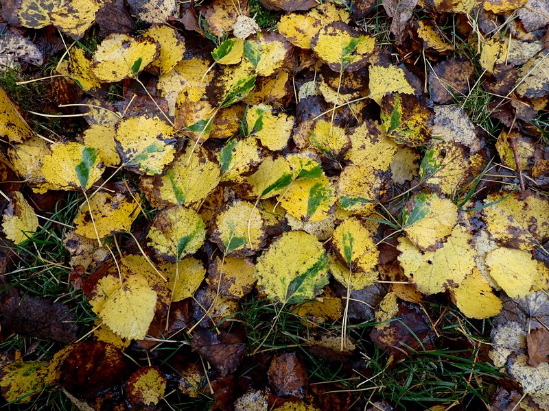
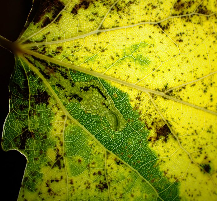
The larva feeds exclusively on the leaves and leaf stalks (petiole) of aspen (Populus tremula and Populus tremuloides). The larva initially bores into and galls the petiole before moving into the leaf blade. It creates a triangular full depth blotch mine extending from the midrib. Frass is deposited along the midrib and lateral vein creating a V-shaped frass-line.
“Green Island” Phenomenon: The most notable characteristic of this species is that the area of the leaf mine often remains green even after the surrounding aspen leaf has turned yellow and fallen in the autumn. This “green island” helps identify the moth’s presence in fallen leaves.


Image Gallery


Temporal Distribution Chart
Immatures: (between 2018 - 2025)
Distribution Map for Ectoedemia argyropeza
↳ from 2026+
↳ 4 from 2020 - 2025
↳ 1 from Before 2020
If the Map Layers function fails, just refresh the page and it should be OK after. Use the +- zoom on the top left, or on a tablet, use two fingers to zoom. Remember, the last layer you ticked is the one which displays the popup information - they sit on top of each other - de-select then re-select, to see the popup values.
Bedrock Geology ** indirectly affects moth distribution by influencing the type of habitat and food plants available in an area. In turn, this may affect the types of moths that can thrive, or where they can most likely be found.
NBN Atlas UK Distribution for – Ectoedemia argyropeza
⚠️ Please wait for the map to load fully – do not click the link shown.
Note – the NBN Atlas datasets are listed in the map below and vary in their currency (uptodateness) – however,
the map does give a general indication of the moth's distribution across the UK.
Monthly Records By Year:
Ectoedemia argyropeza
( data includes both Larvae and Adult Stages )
Monthly Counts By Year:
Ectoedemia argyropeza
( data is based on 'Adult' stage records only )
First/Last Recorded Dates: Ectoedemia argyropeza
Adult-only & Anything [Larvae, Pupae, Adult, Mines]
Shading shows moth presence between dates
Click the colour discs below to Select/De-select as Required
Recordings By Year: Ectoedemia argyropeza
( All data includes both Larvae and Adult Stages )
Annual Growth Rate (AGR): Ectoedemia argyropeza
AGR: 52.67% | Total % Change: 1833.3%
Hectad (10kmx10km) Coverage: Ectoedemia argyropeza
( data includes both Larvae and Adult Stages )
Flight Periods – Indicative –vs– Recorded Data
Ectoedemia argyropeza
Ectoedemia argyropeza
Flight Period chart – the grey hatched area above, which can cross one or more months, pictorially represents the best guess we have for this moth's flight periods [month/s]. The coloured lines represent the actual months seen in flight, from site observation records received between 2020-2026.
Mine Periods – Indicative –vs– Recorded Data
Ectoedemia argyropeza
Ectoedemia argyropeza
( data includes both Larvae and Adult Stages )
Mine Period chart – the grey hatched area above, which can cross one or more months, pictorially represents the best guess we have for this moth's mine periods [month/s]. The coloured lines represent the actual months seen mining, from site observation records received between 2020-2026.
Records Behind the Map and Charts - Ectoedemia argyropeza – 5 records available
Listed by Year - descending - scroll across to see all table columns
| Site Name | Tetrad | Date | Count | Stage | Recorder | Source | RecordKey |
|---|---|---|---|---|---|---|---|
| Glossop, Hague Street | SK09G | 24/11/2025 | 5 | Leaf-mine | Heintzen, Christian | vc57_irecords_extract | iBRC47521401 |
| Hayfield-Birch Vale, Sett Valley Trail | SK08D | 13/11/2025 | 50 | Leaf-mine | Heintzen, Christian | vc57_irecords_extract | iBRC47521393 |
| Markham Vale South Tip | SK47L | 26/10/2025 | 3 | mine | Radford, Mark | vc57_irecords_extract | iBRC46116463 |
| Pottery Wood | SK32G | 05/11/2024 | 1 | Mine | Finch, Graham Leonard | vc57_irecords_extract | iBRC41038949 |
| Grange Wood | SK21S | 13/09/2018 | 1 | Mine | Finch, Graham Leonard | vc57_irecords_extract | iBRC35106428 |