 – click for General Verification Guidelines | – click for Specific Verification Guidelines
  – Generally Common / Widespread
  – Day-flying
Blue-coded] moths are not stored on the website at this current time. 

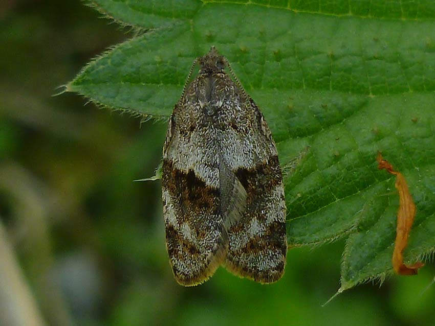
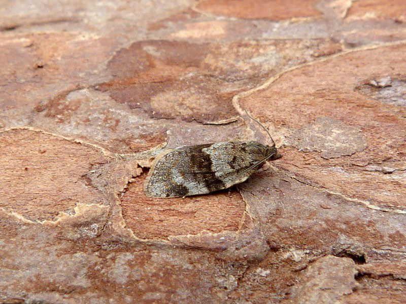
Image Gallery

Distribution Map for Syndemis musculana
↳ 16 from After 2025
↳ 56 from 2020 - 2024
↳ 68 from Before 2020
If the Map Layers function fails, just refresh the page and it should be OK after. Use the +- zoom on the top left, or on a tablet, use two fingers to zoom. Remember, the last layer you ticked is the one which displays the popup information - they sit on top of each other - de-select then re-select, to see the popup values.
Bedrock Geology ** indirectly affects moth distribution by influencing the type of habitat and food plants available in an area. In turn, this may affect the types of moths that can thrive, or where they can most likely be found.
NBN Atlas UK Distribution for – Syndemis musculana
⚠️ Please wait for the map to load fully – do not click the link shown.
Note – the NBN Atlas datasets are listed in the map below and vary in their currency (uptodateness) – however,
the map does give a general indication of the moth's distribution across the UK.
Monthly Records By Year:
Syndemis musculana
( data includes both Larvae and Adult Stages )
Monthly Counts By Year: Syndemis musculana
( data is based on 'Adult' stage records only. )
First/Last Recorded Dates: Syndemis musculana
Adult-only & Anything [Larvae, Pupae, Adult, Mines]
Shading shows moth presence between dates
Click the colour discs below to Select/De-select as Required
Recordings By Year: Syndemis musculana
( All data includes both Larvae and Adult Stages )
Annual Growth Rate (AGR): Syndemis musculana
AGR: 0.78% | Total % Change: 18.8%
CUSUM Analysis: Syndemis musculana
Counts for the current year (2025) are pro-rated based on data available up to month 8 (August) to provide a full-year equivalent.
What the Y-axis "Cumulative Deviation" means: Cumulative Deviation shows the running total of how each year’s moth population count differs from the long-term average. i
Hectad (10kmx10km) Coverage: Syndemis musculana
( data includes both Larvae and Adult Stages )
Flight Periods – Indicative –vs– Recorded Data
Syndemis musculana
Syndemis musculana
( data includes Adult Stage only )
Flight Period chart – the grey hatched area above, which can cross one or more months, pictorially represents the best guess we have for this moth's flight periods [month/s]. The coloured lines represent the actual months seen in flight, from site observation records received between 2020-2025.
Records Behind the Map and Charts - Syndemis musculana – 140 records available
Listed by Year - descending - scroll across to see all table columns
| Site Name | Tetrad | Date | Count | Stage | Source |
|---|---|---|---|---|---|
| Belper, Derbyshire | SK34N | 11/07/2025 | 1 | adult | vc57_irecords_extract |
| Allestree, Derby | SK33P | 02/05/2025 | 2 | adult | vc57_irecords_extract |
| Havercroft Road | SK38L | 12/05/2025 | 1 | adult | vc57_irecords_extract |
| White Knowle Road, Buxton | SK07R | 13/05/2025 | 1 | Adult | vc57_irecords_extract |
| Inkersall garden | SK47G | 17/05/2025 | 1 | adult | vc57_irecords_extract |
| Staveley garden SYA | SK47H | 16/05/2025 | 1 | adult | vc57_irecords_extract |
| Sheffield | SK38M | 13/05/2025 | 1 | adult | vc57_irecords_extract |
| Buxton: Light Wood | SK07M | 18/05/2025 | 1 | adult | vc57_irecords_extract |
| Buxton: Flint Clough | SK07M | 18/05/2025 | 2 | adult | vc57_irecords_extract |
| Miller's Dale: bank of River Wye | SK17L | 19/05/2025 | 1 | adult | vc57_irecords_extract |
| Chaddesden, Derby | SK33T | 01/05/2025 | 1 | adult | vc57_irecords_extract |
| Chaddesden, Derby | SK33T | 27/05/2025 | 2 | adult | vc57_irecords_extract |
| Belper, Derbyshire | SK34N | 01/05/2025 | 1 | adult | vc57_irecords_extract |
| Longdendale, Torside grassland and willow carr | SK09U | 12/05/2025 | 1 | adult | vc57_irecords_extract |
| Derbyshire Wild Life Trust Long Clough, Herod Clough | SK09G | 24/05/2025 | 1 | adult | vc57_irecords_extract |
| upper cromford garden | SK25Y | 30/04/2025 | 1 | adult | vc57_irecords_extract |
| Belper | SK34N | 17/06/2024 | 1 | adult | vc57_irecords_extract |
| Belper | SK34N | 09/05/2024 | 1 | adult | vc57_irecords_extract |
| Allestree, Derby | SK33P | 10/05/2024 | 1 | adult | vc57_irecords_extract |
| Brockwell Chesterfield , Derbyshire. | SK37Q | 11/05/2024 | 1 | adult | vc57_irecords_extract |
| South Yorkshire, England, GB | SK38L | 17/05/2024 | 1 | Adult | vc57_irecords_extract |
| Ninelands Road | SK28F | 11/05/2024 | 1 | adult | vc57_irecords_extract |
| Ninelands Road | SK28F | 17/05/2024 | 1 | adult | vc57_irecords_extract |
| Bridgeway, High Peak, England, GB | SK07P | 19/05/2024 | 1 | Adult | vc57_irecords_extract |
| Ingleby Ave, Derby | SK33L | 25/05/2024 | 1 | adult | vc57_irecords_extract |
| Havercroft Road | SK38L | 17/05/2024 | 1 | Adult | vc57_irecords_extract |
| Havercroft Road | SK38L | 26/05/2024 | 1 | Adult | vc57_irecords_extract |
| Allestree, Derby | SK33P | 31/05/2024 | 1 | adult | vc57_irecords_extract |
| Derbyshire Wild Life Trust Long Clough | SK09G | 10/05/2024 | 1 | adult | vc57_irecords_extract |
| Glossop, The Twitchlings | SK09K | 11/05/2024 | 1 | adult | vc57_irecords_extract |
| Glossop, The Twitchlings | SK09M | 11/05/2024 | 1 | adult | vc57_irecords_extract |
| Glossop, Gnat Hole Rough Fields | SK09L | 12/05/2024 | 1 | adult | vc57_irecords_extract |
| Derbyshire Wild Life Trust Long Clough | SK09G | 15/05/2024 | 4 | adult | vc57_irecords_extract |
| Glossop, Shire Hill, south | SK09M | 16/05/2024 | 2 | adult | vc57_irecords_extract |
| Glossop, The Twitchlings | SK09M | 17/05/2024 | 2 | adult | vc57_irecords_extract |
| Longdendale, Wildboar Clough | SK09U | 19/05/2024 | 10 | adult | vc57_irecords_extract |
| Derbyshire Wild Life Trust Long Clough | SK09G | 25/05/2024 | 5 | adult | vc57_irecords_extract |
| Longdendale, Wildboar Clough | SK09U | 30/05/2024 | 1 | adult | vc57_irecords_extract |
| Sandiacre Garden | SK43T | 17/05/2024 | 1 | adult | vc57_irecords_extract |
| Findern, Derbyshire, DEAZ | SK33A | 10/05/2024 | 1 | adult | vc57_irecords_extract |
| Drakelow, Derbys. | SK22F | 07/05/2024 | 1 | adult | vc57_irecords_extract |
| Allestree, Derby | SK33P | 10/05/2024 | 1 | adult | vc57_irecords_extract |
| Allestree, Derby | SK33P | 12/05/2024 | 2 | adult | vc57_irecords_extract |
| Woodland Ave | SK43R | 07/07/2023 | 1 | adult | vc57_irecords_extract |
| White Knowle Road, Buxton | SK07R | 11/06/2023 | 1 | Adult | vc57_irecords_extract |
| Belper Garden | SK34P | 09/06/2023 | 1 | adult | vc57_irecords_extract |
| Alicehead, Chesterfield | SK36H | 05/06/2023 | 1 | Adult | vc57_irecords_extract |
| Sandiacre | SK43T | 19/05/2023 | 1 | adult | vc57_irecords_extract |
| Findern Garden | SK33A | 06/05/2023 | 1 | Adult | vc57_irecords_extract |
| Derbyshire Wild Life Trust Long Clough | SK09G | 08/05/2023 | 1 | adult | vc57_irecords_extract |
| Derbyshire Wild Life Trust Long Clough | SK09G | 16/05/2023 | 1 | adult | vc57_irecords_extract |
| Derbyshire Wild Life Trust Long Clough | SK09G | 30/05/2023 | 1 | adult | vc57_irecords_extract |
| Ferneydale Avenue | SK07Q | 02/06/2022 | 1 | adult | vc57_irecords_extract |
| Sett Valley | SJ98X | 17/05/2022 | 1 | larva | vc57_irecords_extract |
| Birch Vale | SK08I | 19/05/2022 | 1 | adult | vc57_irecords_extract |
| Ferneydale Avenue | SK07Q | 11/05/2022 | 1 | adult | vc57_irecords_extract |
| Sandiacre | SK43T | 20/05/2022 | 1 | adult | vc57_irecords_extract |
| Torside | SK09U | 26/09/2021 | 1 | larva | vc57_irecords_extract |
| Peak District National Park, Bakewell, England, GB | SK26E | 16/06/2021 | 1 | Adult | vc57_irecords_extract |
| Hathersage, Derbyshire, UK | SK28F | 09/06/2021 | 1 | adult | vc57_irecords_extract |
| Hathersage, Derbyshire, UK | SK28F | 09/06/2021 | 1 | adult | vc57_irecords_extract |
| Birch Vale | SK08I | 06/06/2021 | 1 | Adult | vc57_irecords_extract |
| Birch Vale | SK08I | 09/06/2021 | 3 | Adult | vc57_irecords_extract |
| Midway, Derbys. | SK32A | 10/06/2021 | 1 | adult | vc57_irecords_extract |
| Ferneydale Avenue | SK07Q | 05/06/2021 | 1 | adult | vc57_irecords_extract |
| Ferneydale Avenue | SK07Q | 13/06/2021 | 1 | adult | vc57_irecords_extract |
| Ferneydale Avenue | SK07Q | 17/06/2021 | 1 | adult | vc57_irecords_extract |
| Hathersage, Derbyshire, UK | SK28F | 09/05/2021 | 1 | adult | vc57_irecords_extract |
| Woodland Ave | SK43R | 06/07/2020 | 1 | adult | vc57_irecords_extract |
| Buxton SK, UK | SK07S | 27/05/2020 | 1 | Adult | vc57_irecords_extract |
| Ladycroft Ave, Buxton | SK07S | 21/05/2020 | 1 | adult | vc57_irecords_extract |
| Havercroft Road | SK38L | 18/05/2020 | 1 | Adult | vc57_irecords_extract |
| Birch Vale | SK08I | 01/06/2019 | 2 | adult | vc57_irecords_extract |
| Havercroft Road | SK38L | 02/06/2019 | 1 | Adult | vc57_irecords_extract |
| Havercroft Road | SK38L | 25/05/2019 | 1 | Adult | vc57_irecords_extract |
| Birch Vale | SK08I | 19/05/2018 | 1 | adult | vc57_irecords_extract |
| Birch Vale | SK08I | 13/05/2018 | 1 | adult | vc57_irecords_extract |
| Sheffield, England, United Kingdom | SK38L | 01/06/2017 | 1 | Adult | vc57_irecords_extract |
| White Knowle Road, Buxton | SK07R | 18/04/2017 | 1 | Adult | vc57_irecords_extract |
| White Knowle Road, Buxton | SK07R | 18/04/2017 | 1 | adult | vc57_irecords_extract |
| Wood Lane,Newhall,Swadlincote | SK22V | 23/05/2014 | 1 | Adult | vc57_danes_bc_data |
| Millennium Meadow NR, Duffield | SK34L | 20/05/2013 | 1 | Adult | vc57_danes_bc_data |
| White Knowle Rd, Buxton | SK07R | 06/06/2012 | 1 | Adult | vc57_irecords_extract |
| White Knowle Road, Buxton | SK07R | 06/06/2012 | 1 | Adult | vc57_irecords_extract |
| Wood Lane,Newhall,Swadlincote | SK22V | 05/06/2012 | 1 | Adult | vc57_danes_bc_data |
| Welbeck Drive,Wingerworth | SK36T | 12/06/2012 | 1 | Adult | vc57_danes_bc_data |
| Jackson's Ln | SK34U | 21/05/2012 | 1 | Adult | vc57_irecords_extract |
| Backgarden Marehay | SK34Z | 06/05/2011 | 1 | adult | vc57_irecords_extract |
| Backgarden Marehay | SK34Z | 07/05/2011 | 4 | adult | vc57_irecords_extract |
| Backgarden Marehay | SK34Z | 17/05/2011 | 1 | adult | vc57_irecords_extract |
| School Close,Parkway Gardens,Darley Dale | SK26R | 06/05/2011 | 1 | Adult | vc57_danes_bc_data |
| Bamford St,Ripley | SK34Z | 06/05/2011 | 1 | Adult | vc57_danes_bc_data |
| Bamford St,Ripley | SK34Z | 07/05/2011 | 4 | Adult | vc57_danes_bc_data |
| School Close,Parkway Gardens,Darley Dale | SK26R | 08/05/2011 | 1 | Adult | vc57_danes_bc_data |
| Crich Chase,Ambergate | SK35L | 17/05/2011 | 1 | Adult | vc57_danes_bc_data |
| Bamford St,Ripley | SK34Z | 17/05/2011 | 1 | Adult | vc57_danes_bc_data |
| The Hollies,Station Rd,Darley Dale | SK26R | 28/04/2011 | 1 | Adult | vc57_danes_bc_data |
| Backgarden Marehay | SK34Z | 16/07/2010 | 1 | adult | vc57_irecords_extract |
| Bamford St,Ripley | SK34Z | 16/07/2010 | 1 | Adult | vc57_danes_bc_data |
| Backgarden Marehay | SK34Z | 05/06/2010 | 1 | adult | vc57_irecords_extract |
| Wood Lane,Newhall,Swadlincote | SK22V | 04/06/2010 | 1 | Adult | vc57_danes_bc_data |
| Rose Av,Clowne | SK57D | 09/06/2010 | 1 | Adult | vc57_danes_bc_data |
| Millstone Edge,Hathersage | SK28K | 04/06/2010 | 1 | Adult | vc57_danes_bc_data |
| Bamford St,Ripley | SK34Z | 05/06/2010 | 1 | Adult | vc57_danes_bc_data |
| Rose Av,Clowne | SK57D | 07/06/2010 | 1 | Adult | vc57_danes_bc_data |
| Elm Wood,Derby | SK33R | 22/05/2010 | 1 | Adult | vc57_danes_bc_data |
| Hardhurst Rd, Alvaston, Derby | SK33W | 22/05/2010 | 2 | Adult | vc57_danes_bc_data |
| Ladycroft Ave,Buxton | SK07S | 23/05/2010 | 2 | Adult | vc57_danes_bc_data |
| Rose Av,Clowne | SK57D | 24/05/2010 | 1 | Adult | vc57_danes_bc_data |
| Ladycroft Ave,Buxton | SK07S | 21/05/2010 | 1 | Adult | vc57_danes_bc_data |
| Newboundmill Lane,Pleasley | SK56C | 18/04/2010 | 1 | Adult | vc57_danes_bc_data |
| Carver Rocks area, Hartshorne | SK32G | 16/05/2009 | 1 | Adult | vc57_danes_bc_data |
| Newboundmill Lane,Pleasley | SK56C | 04/06/2008 | 2 | Adult | vc57_danes_bc_data |
| Millstone Edge,Hathersage | SK28K | 06/06/2008 | 1 | Adult | vc57_danes_bc_data |
| Midway Rd,Midway,Swadlincote | SK32A | 31/05/2008 | 1 | Adult | vc57_danes_bc_data |
| Midway Rd,Midway,Swadlincote | SK32A | 10/05/2008 | 1 | Adult | vc57_danes_bc_data |
| Carvers Rocks (old toilet block area) | SK32G | 10/05/2008 | 2 | Adult | vc57_danes_bc_data |
| Beeley Moor, Beeley | SK26Y | 06/06/2007 | 2 | Adult | vc57_danes_bc_data |
| Calke Park Ridge from Fisherman's Car Park | SK32R | 24/04/2007 | 1 | adult | vc57_irecords_extract |
| Calke Park,Ticknall | SK32R | 24/04/2007 | 1 | Adult | vc57_danes_bc_data |
| Midway Rd,Midway,Swadlincote | SK32A | 21/07/2006 | 1 | Adult | vc57_danes_bc_data |
| Robin Wood | SK32M | 23/06/2006 | 1 | Adult | vc57_irecords_extract |
| South Wood, Calke, Ticknall | SK32Q | 01/06/2006 | 2 | Adult | vc57_danes_bc_data |
| Robin Wood (centre area track), Ticknall | SK32M | 23/06/2006 | 1 | Adult | vc57_danes_bc_data |
| The Hollies,Station Rd,Darley Dale | SK26R | 27/05/2006 | 1 | Adult | vc57_danes_bc_data |
| Foremark Resr, Ticknall | SK32H | 12/05/2006 | 3 | Adult | vc57_danes_bc_data |
| Clough Wood,Darley Dale | SK26K | 17/06/2005 | 1 | Adult | vc57_danes_bc_data |
| Edgecote Drive,Newhall,Swadlincote | SK22V | 05/06/2004 | 1 | Adult | vc57_danes_bc_data |
| Main Street, Kings Newton | SK32Y | 17/05/2004 | 1 | Adult | vc57_irecords_extract |
| Edgecote Drive,Newhall,Swadlincote | SK22V | 10/05/2004 | 1 | Adult | vc57_danes_bc_data |
| Rose End Meadows NR,Cromford | SK25Y | 10/05/2004 | 1 | Adult | vc57_danes_bc_data |
| Wood Lane,Newhall,Swadlincote | SK22V | 22/06/2003 | 1 | Adult | vc57_danes_bc_data |
| Calke Park (Betty's Pool & Poker's Leys), Ticknall | SK32R | 22/05/1998 | 1 | Adult | vc57_danes_bc_data |
| Slagmill Plantation, Beeley Moor (site not precise) | SK36E | 14/06/1994 | 1 | Adult | vc57_danes_bc_data |
| Hell Bank Plantation (site not precise) | SK26Z | 19/06/1994 | 1 | Adult | vc57_danes_bc_data |
| Clough Wood,Darley Dale | SK26K | 27/04/1993 | 1 | Adult | vc57_danes_bc_data |
| Deerlands Rd, Ashgate, Chesterfield | SK37K | 10/05/1990 | 1 | Adult | vc57_danes_bc_data |
| Carvers Rocks NR,Hartshorne,Swadlincote | SK32G | 08/06/1979 | 1 | Adult | vc57_danes_bc_data |
| Carvers Rocks NR,Hartshorne,Swadlincote | SK32G | 29/05/1979 | 1 | Adult | vc57_danes_bc_data |
| Hunger Hill, Holymoorside | SK36I | 31/05/1963 | 1 | Adult | vc57_danes_bc_data |