 Leaf-miner: CAT L – The leaf or a Photo required –
  Larval Case: C1 – Distinctive Species –
  – click for General Verification Guidelines | – click for Specific Verification Guidelines
  – Uncertain/Unknown – Insufficient Data
  – Leaf Miner
Confusion Species: Ectoedemia intimella, Stigmella catharticella
Mine Period Additional: None.
Mine ID Difficulty:
Mine Type/s: Gallery, Blotch
Mine Feeding Method/s: Not Recorded
Mine Comment: Larvae mine the leaves of St.John’s-wort, first as a narrow gallery then later as a blotch
Buxton – Jon Mortin©/ Markham Vale (July 2025) Mark Radford© / Longdendale (September 2025) and Glossop Oct 2025 Christian Heintzen©

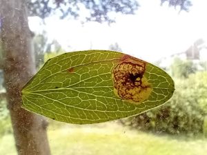
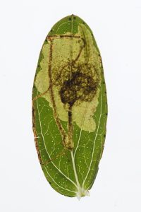


Image Gallery


Distribution Map for Fomoria septembrella
↳ from 2026+
↳ 7 from 2020 - 2025
↳ 12 from Before 2020
If the Map Layers function fails, just refresh the page and it should be OK after. Use the +- zoom on the top left, or on a tablet, use two fingers to zoom. Remember, the last layer you ticked is the one which displays the popup information - they sit on top of each other - de-select then re-select, to see the popup values.
Bedrock Geology ** indirectly affects moth distribution by influencing the type of habitat and food plants available in an area. In turn, this may affect the types of moths that can thrive, or where they can most likely be found.
NBN Atlas UK Distribution for – Fomoria septembrella
⚠️ Please wait for the map to load fully – do not click the link shown.
Note – the NBN Atlas datasets are listed in the map below and vary in their currency (uptodateness) – however,
the map does give a general indication of the moth's distribution across the UK.
Monthly Records By Year:
Fomoria septembrella
( data includes both Larvae and Adult Stages )
Monthly Counts By Year: Fomoria septembrella
( data is based on 'Adult' stage records only. )
First/Last Recorded Dates: Fomoria septembrella
Adult-only & Anything [Larvae, Pupae, Adult, Mines]
Shading shows moth presence between dates
Click the colour discs below to Select/De-select as Required
Recordings By Year: Fomoria septembrella
( All data includes both Larvae and Adult Stages )
Annual Growth Rate (AGR): Fomoria septembrella
AGR: 1.64% | Total % Change: 50%
Hectad (10kmx10km) Coverage: Fomoria septembrella
( data includes both Larvae and Adult Stages )
Flight Periods – Indicative –vs– Recorded Data
Fomoria septembrella
Fomoria septembrella
( data includes Adult Stage only )
Flight Period chart – the grey hatched area above, which can cross one or more months, pictorially represents the best guess we have for this moth's flight periods [month/s]. The coloured lines represent the actual months seen in flight, from site observation records received between 2020-2026.
Mine Periods – Indicative –vs– Recorded Data
Fomoria septembrella
Fomoria septembrella
( data includes both Larvae and Adult Stages )
Mine Period chart – the grey hatched area above, which can cross one or more months, pictorially represents the best guess we have for this moth's mine periods [month/s]. The coloured lines represent the actual months seen mining, from site observation records received between 2020-2026.
Records Behind the Map and Charts - Fomoria septembrella – 19 records available
Listed by Year - descending - scroll across to see all table columns
| Site Name | Tetrad | Date | Count | Stage | Source |
|---|---|---|---|---|---|
| Glossop, Hague Street | SK09G | 08/10/2025 | 2 | Leaf-mine | vc57_irecords_extract |
| Trans Pennine Trail, Woodhead | SK09Z | 04/10/2025 | 1 | Leaf-mine | vc57_irecords_extract |
| Lower Gamesley VC | SK09C | 31/08/2024 | 1 | mine (tenant | vc57_irecords_extract |
| Deep Dale, Topley Pike | SK17B | 31/08/2024 | 1 | Mine | vc57_irecords_extract |
| Goyts Lane Pond | SK07H | 24/07/2024 | 1 | mine | vc57_irecords_extract |
| Coombs Dale, Stoney Middleton | SK27H | 21/07/2024 | 1 | Mine | vc57_irecords_extract |
| Coombs Dale, Stoney Middleton | SK27H | 21/07/2024 | 1 | Larva | vc57_irecords_extract |
| Millers Dale | SK17G | 03/09/2011 | 1 | Larval Mine | vc57_danes_bc_data |
| Ashford in the Water | SK16Z | 22/09/2010 | 1 | Larval Mine | vc57_danes_bc_data |
| Bamford | SK28B | 21/09/2010 | 1 | Larval Mine | vc57_danes_bc_data |
| Hopton Wood Quarry NR | SK25T | 16/10/2009 | 1 | Larval Mine | vc57_danes_bc_data |
| Coombs Dale,Stoney Middleton | SK27H | 12/10/2009 | 1 | Larval Mine | vc57_danes_bc_data |
| Tissington Trail, Ashbourne | SK14T | 01/10/2009 | 1 | Larval Mine | vc57_danes_bc_data |
| Pin Dale | SK18L | 10/09/2009 | 1 | Larval Mine | vc57_danes_bc_data |
| Lathkill Dale,Bakewell | SK16Y | 19/09/2008 | 1 | Larval Mine | vc57_danes_bc_data |
| Monks Dale, Buxton | SK17G | 14/09/2008 | 1 | Larval Mine | vc57_danes_bc_data |
| Cubley, nr Ashbourne | SK13T | 04/10/2001 | 1 | Larval Mine | vc57_danes_bc_data |
| Broomfield Hall, Morley, Derby | SK34V | 04/11/2000 | 1 | Larval Mine | vc57_danes_bc_data |
| Broomfield Hall, Morley, Derby | SK34V | 02/11/1996 | 1 | Larval Mine | vc57_danes_bc_data |