
 Leaf-miner: CAT L – The leaf or a Photo required –
  Larval Case: C1 – Distinctive Species –
  – click for General Verification Guidelines | – click for Specific Verification Guidelines
  – Uncertain/Unknown – Insufficient Data
  – Leaf-miner
Confusion Species: Stigmella filipendulae
Mine Period Additional: Larvae are found in July and again in September/October.
Mine ID Difficulty:
Mine Type/s: Gallery, Blotch
Mine Feeding Method/s: Not Recorded
Mine Comment: The larvae create a distinctive mine in the leaf that starts as a narrow, winding gallery with a central line of frass. This gallery then abruptly widens into a roundish or “tadpole” shaped blotch.
Wyver Lane – Dave Evans©; Monsal Head – Martin Harvey©; Rose End Meadows – Steve Orridge©/ Sunnyhill Park 2025 – Andrew-John Shervill© / Glossop 28/8/2025 – Christian Heintzen©


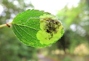
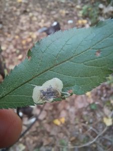


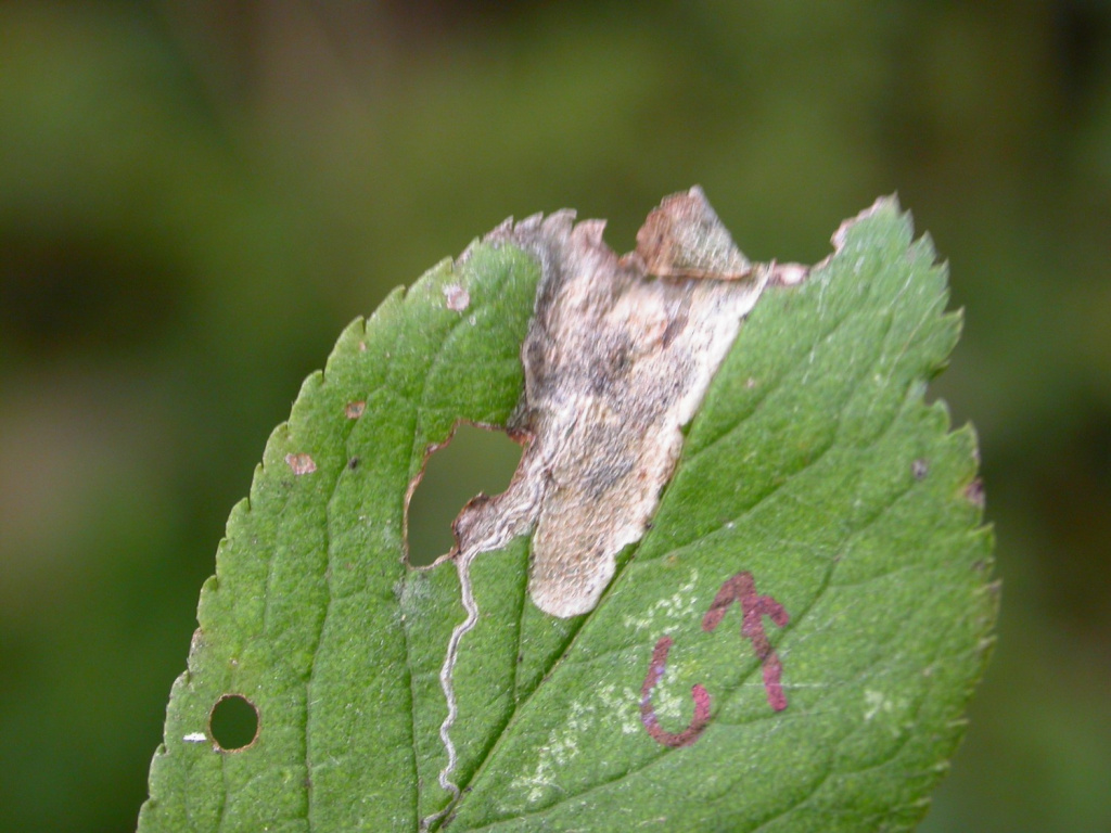


Image Gallery


Temporal Distribution Chart
Immatures: (between 2009 - 2025)
Distribution Map for Stigmella plagicolella
↳ from 2026+
↳ 23 from 2020 - 2025
↳ 11 from Before 2020
If the Map Layers function fails, just refresh the page and it should be OK after. Use the +- zoom on the top left, or on a tablet, use two fingers to zoom. Remember, the last layer you ticked is the one which displays the popup information - they sit on top of each other - de-select then re-select, to see the popup values.
Bedrock Geology ** indirectly affects moth distribution by influencing the type of habitat and food plants available in an area. In turn, this may affect the types of moths that can thrive, or where they can most likely be found.
NBN Atlas UK Distribution for – Stigmella plagicolella
⚠️ Please wait for the map to load fully – do not click the link shown.
Note – the NBN Atlas datasets are listed in the map below and vary in their currency (uptodateness) – however,
the map does give a general indication of the moth's distribution across the UK.
Monthly Records By Year:
Stigmella plagicolella
( data includes both Larvae and Adult Stages )
Monthly Counts By Year:
Stigmella plagicolella
( data is based on 'Adult' stage records only )
First/Last Recorded Dates: Stigmella plagicolella
Adult-only & Anything [Larvae, Pupae, Adult, Mines]
Shading shows moth presence between dates
Click the colour discs below to Select/De-select as Required
Recordings By Year: Stigmella plagicolella
( All data includes both Larvae and Adult Stages )
Annual Growth Rate (AGR): Stigmella plagicolella
AGR: 23.5% | Total % Change: 2830%
Hectad (10kmx10km) Coverage: Stigmella plagicolella
( data includes both Larvae and Adult Stages )
Flight Periods – Indicative –vs– Recorded Data
Stigmella plagicolella
Stigmella plagicolella
Flight Period chart – the grey hatched area above, which can cross one or more months, pictorially represents the best guess we have for this moth's flight periods [month/s]. The coloured lines represent the actual months seen in flight, from site observation records received between 2020-2026.
Mine Periods – Indicative –vs– Recorded Data
Stigmella plagicolella
Stigmella plagicolella
( data includes both Larvae and Adult Stages )
Mine Period chart – the grey hatched area above, which can cross one or more months, pictorially represents the best guess we have for this moth's mine periods [month/s]. The coloured lines represent the actual months seen mining, from site observation records received between 2020-2026.
Records Behind the Map and Charts - Stigmella plagicolella – 34 records available
Listed by Year - descending - scroll across to see all table columns
| Site Name | Tetrad | Date | Count | Stage | Recorder | Source | RecordKey |
|---|---|---|---|---|---|---|---|
| Swarkestone | SK32P | 11/10/2025 | 250 | mine | Shervill, Andrew | vc57_irecords_extract | iBRC45891618 |
| Markham Vale South Tip | SK47K | 01/10/2025 | 1 | mine | Radford, Mark | vc57_irecords_extract | iBRC45728015 |
| Sunnyhill Park, Derby | SK33L | 23/09/2025 | 10 | mine | Shervill, Andrew | vc57_irecords_extract | iBRC45506984 |
| DWT Wyver Lane | SK34P | 09/09/2025 | 2 | mine (empty) | Evans, Dave | vc57_irecords_extract | iBRC45208275 |
| DWT Wyver Lane | SK34P | 02/09/2025 | 5 | mine (empty) | Evans, Dave | vc57_irecords_extract | iBRC45019573 |
| Gleadless Valley LNR - land near Newfield School | SK38L | 29/08/2025 | 1 | mine | Mella, Pete | vc57_irecords_extract | iBRC48913205 |
| Glossop, Gnat Hole | SK09L | 28/08/2025 | 3 | Leaf-mine | Heintzen, Christian | vc57_irecords_extract | iBRC47521339 |
| DWT Wyver Lane | SK34P | 20/08/2025 | 12 | mine (empty) | Evans, Dave | vc57_irecords_extract | iBRC44638477 |
| DWT Wyver Lane | SK34P | 13/08/2025 | 6 | mine (empty) | Evans, Dave | vc57_irecords_extract | iBRC44440550 |
| DWT Wyver Lane | SK34P | 06/08/2025 | 3 | mine (empty) | Evans, Dave | vc57_irecords_extract | iBRC44213466 |
| Burton upon Trent | SK32P | 05/11/2024 | 1 | Mine | Finch, Graham Leonard | vc57_irecords_extract | iBRC41038900 |
| Pottery Wood | SK32G | 05/11/2024 | 1 | Mine | Finch, Graham Leonard | vc57_irecords_extract | iBRC41038947 |
| DWT Wyver Lane | SK34P | 30/10/2024 | 1 | mine (empty) | Evans, Dave | vc57_irecords_extract | iBRC39056473 |
| Monsall Head | SK17V | 14/10/2024 | 1 | mine | Harvey, Martin C. | vc57_irecords_extract | iBRC38894096 |
| River Derwent, Derby | SK33S | 21/09/2024 | 2 | mine | Neil Gregory | vc57_irecords_extract | iBRC38567737 |
| River Derwent, Derby | SK33S | 21/09/2024 | 1 | mine | Neil Gregory | vc57_irecords_extract | iBRC38567740 |
| Lower Gamesley VC | SK09C | 31/08/2024 | 1 | mine | Hind, Steve | vc57_irecords_extract | iBRC38243518 |
| Pleasley Pit Country Park | SK46X | 26/08/2024 | 1 | mine (empty) | Beeley, Graham | vc57_irecords_extract | iBRC38120745 |
| Poppy Wood | SK32S | 22/11/2023 | 1 | Mine | Finch, Graham Leonard | vc57_irecords_extract | iBRC35107048 |
| Carver's Rocks | SK32G | 30/09/2023 | 1 | Mine | Finch, Graham Leonard | vc57_irecords_extract | iBRC35106069 |
| Carver's Rocks | SK32G | 30/09/2023 | 1 | Mine | Finch, Graham Leonard | vc57_irecords_extract | iBRC35106070 |
| Carver's Rocks | SK32H | 21/09/2023 | 1 | Mine | Finch, Graham Leonard | vc57_irecords_extract | iBRC35106103 |
| Allestree Park | SK34K | 25/09/2022 | 1 | Mine | Finch, Graham Leonard | vc57_irecords_extract | iBRC35105360 |
| Grange Wood | SK21S | 13/09/2018 | 1 | Mine | Finch, Graham Leonard | vc57_irecords_extract | iBRC35106424 |
| Thorpe, Dovedale | SK15K | 13/10/2010 | 1 | Larval Mine | S.A. Orridge;S.H. Hind | vc57_danes_bc_data | LC000334001COTQY |
| Ashford in the Water | SK16Z | 22/09/2010 | 1 | Larval Mine | S.A. Orridge;S.H. Hind | vc57_danes_bc_data | LC000334001CP6P5 |
| Bamford | SK28B | 21/09/2010 | 1 | Larval Mine | K. McCabe;S.H. Hind | vc57_danes_bc_data | LC000334001COTQB |
| Rose End Meadow | SK25Y | 16/10/2009 | 1 | mine | Orridge, Steve; Hind, Steve, Budworth, Dave | vc57_irecords_extract | iBRC40312701 |
| Cromford, Matlock DE, UK | SK25Y | 16/10/2009 | 1 | Larva | Orridge, Steve | vc57_irecords_extract | iBRC44257392 |
| Cromford | SK25Y | 16/10/2009 | 1 | Larval Mine | Dave Budworth;S.A. Orridge;S.H. Hind | vc57_danes_bc_data | LC000334001CP55U |
| Coombs Dale,Stoney Middleton | SK27H | 12/10/2009 | 1 | Larval Mine | S.H. Hind | vc57_danes_bc_data | LC000334001COWZ9 |
| Stoney Middleton | SK27H | 12/10/2009 | 1 | Larval Mine | S.H. Hind | vc57_danes_bc_data | LC000334001COWZP |
| Coombs Dale,Stoney Middleton | SK27H | 12/10/2009 | 1 | Larval Mine | S.H. Hind | vc57_danes_bc_data | LC000334001CP54A |
| Hope | SK18R | 07/10/2009 | 1 | Larval Mine | S.H. Hind | vc57_danes_bc_data | LC000334001COSZX |