
 Leaf-miner: CAT L – The leaf or a Photo required –
  Larval Case: C1 – Distinctive Species –
  – click for General Verification Guidelines | – click for Specific Verification Guidelines
  – Generally Common / Widespread
  – Leaf-miner
Confusion Species: Stigmella speciosa / Stigmella crataegella
Mine Period Additional: The larvae mine the leaves of Field Maple and Norway Maple from end of June-early July, August-early September.
Mine ID Difficulty:
Mine Type/s: Gallery
Mine Feeding Method/s: Not Recorded
Mine Comment: The larvae create a narrow corridor-shaped (gallery) mine within the leaf, which is initially filled with green frass. As the mine ages, the frass turns brown, making vacated mines easy to spot, especially in autumn.
Blue-coded] moths is not displayed/updated in this tab. However, all verified records for this moth are listed in the RECORDS tab below. Norton Lees (August 2025) Pete Mella© / Willington Wetlands (October 2025) Tony Davison© / Glossop 23/10/2025 – Christian Heintzen©
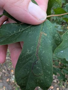


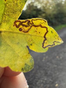


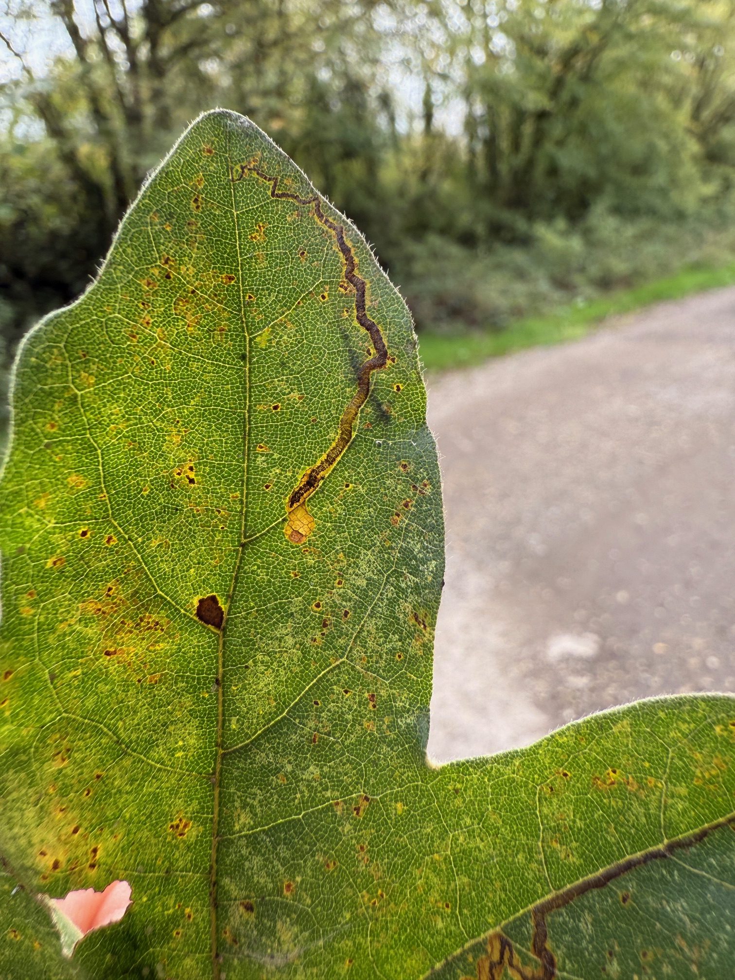
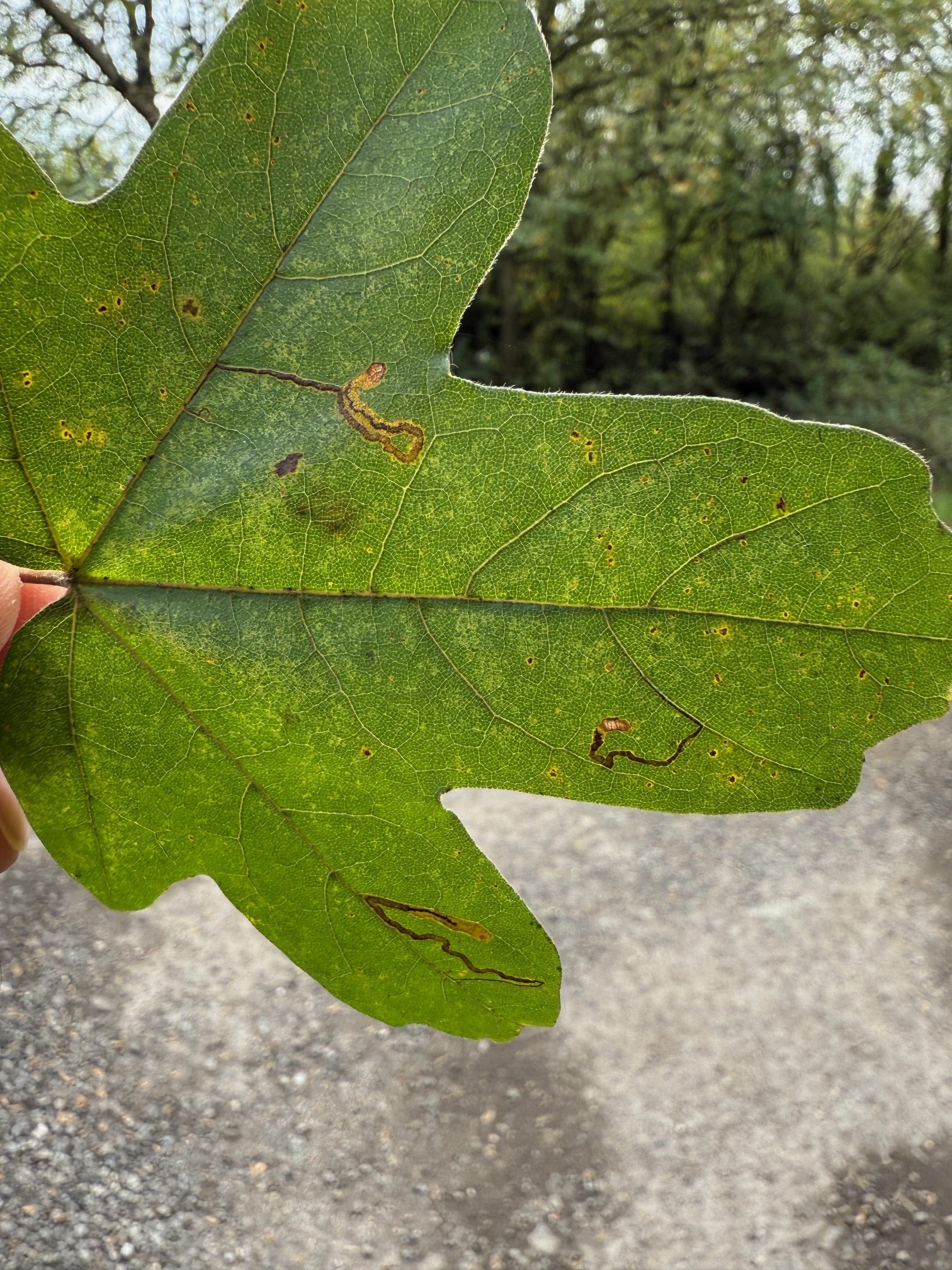

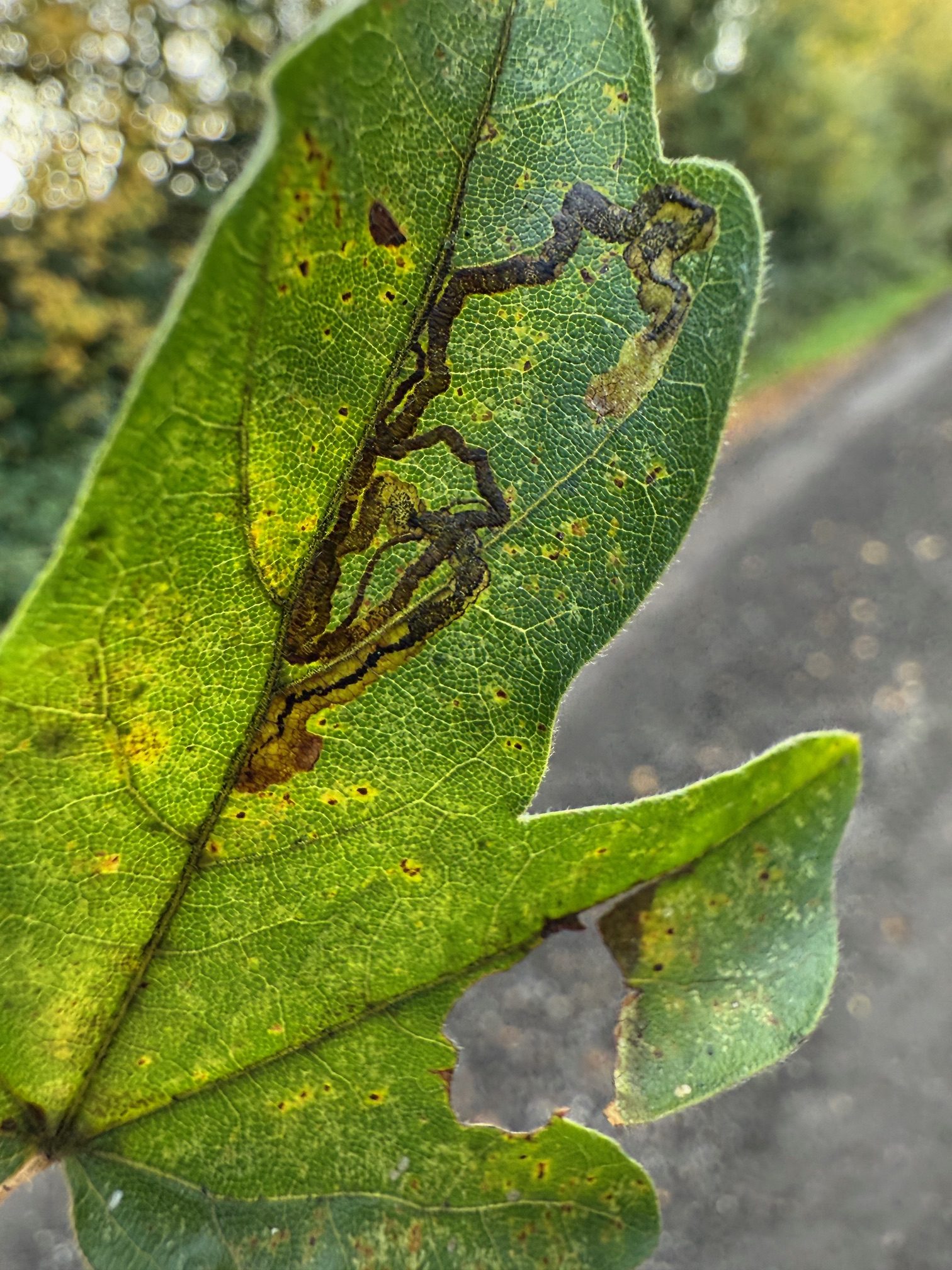
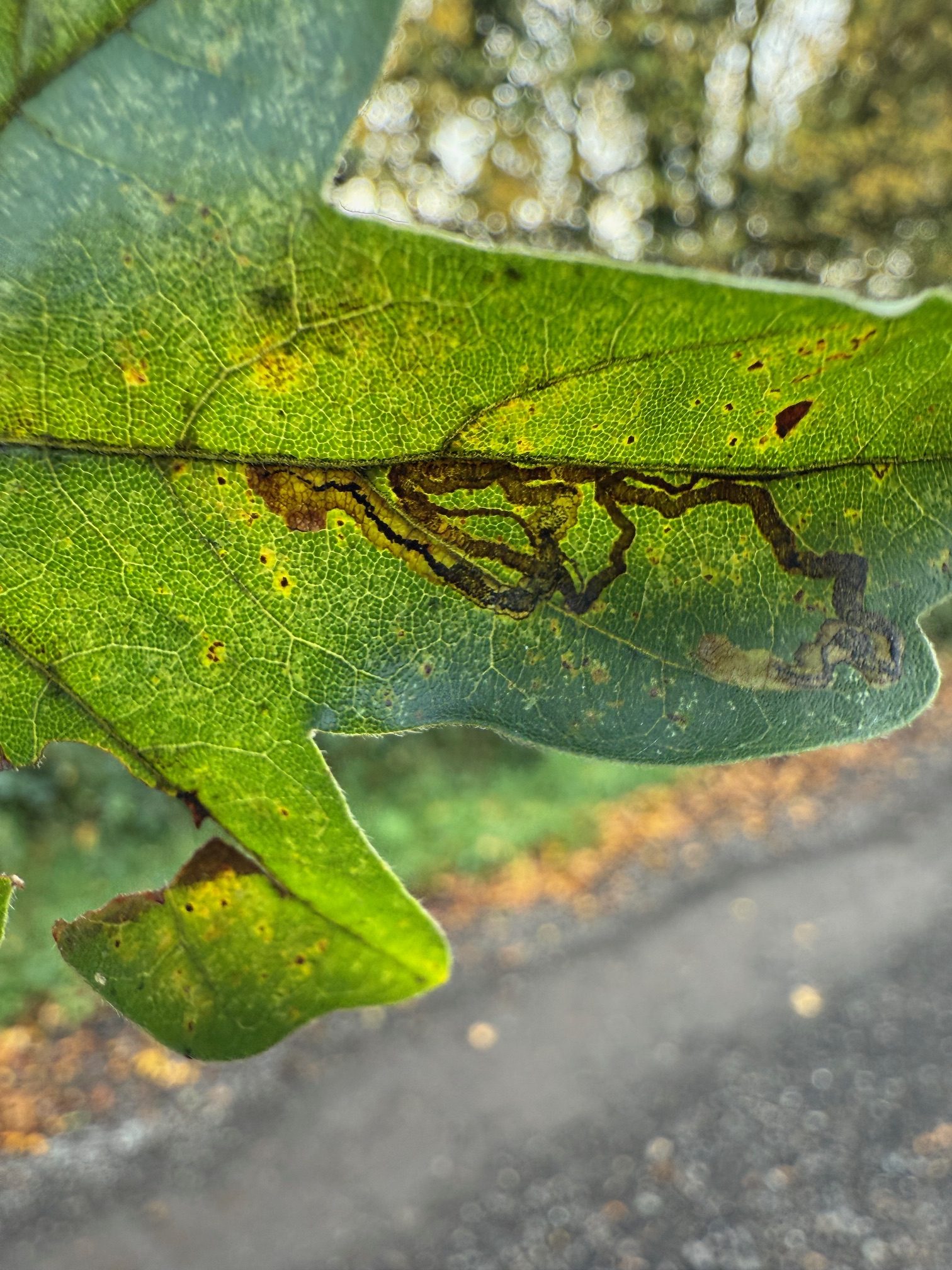

Image Gallery


Temporal Distribution Chart
Immatures: (between 2022 - 2025)
Distribution Map for Stigmella aceris
↳ from 2026+
↳ 23 from 2020 - 2025
↳ from Before 2020
If the Map Layers function fails, just refresh the page and it should be OK after. Use the +- zoom on the top left, or on a tablet, use two fingers to zoom. Remember, the last layer you ticked is the one which displays the popup information - they sit on top of each other - de-select then re-select, to see the popup values.
Bedrock Geology ** indirectly affects moth distribution by influencing the type of habitat and food plants available in an area. In turn, this may affect the types of moths that can thrive, or where they can most likely be found.
NBN Atlas UK Distribution for – Stigmella aceris
⚠️ Please wait for the map to load fully – do not click the link shown.
Note – the NBN Atlas datasets are listed in the map below and vary in their currency (uptodateness) – however,
the map does give a general indication of the moth's distribution across the UK.
Monthly Records By Year:
Stigmella aceris
( data includes both Larvae and Adult Stages )
Monthly Counts By Year:
Stigmella aceris
( data is based on 'Adult' stage records only )
First/Last Recorded Dates: Stigmella aceris
Adult-only & Anything [Larvae, Pupae, Adult, Mines]
Shading shows moth presence between dates
Click the colour discs below to Select/De-select as Required
Recordings By Year: Stigmella aceris
( All data includes both Larvae and Adult Stages )
Annual Growth Rate (AGR): Stigmella aceris
AGR: 123.94% | Total % Change: 1023.1%
Hectad (10kmx10km) Coverage: Stigmella aceris
( data includes both Larvae and Adult Stages )
Flight Periods – Indicative –vs– Recorded Data
Stigmella aceris
Stigmella aceris
Flight Period chart – the grey hatched area above, which can cross one or more months, pictorially represents the best guess we have for this moth's flight periods [month/s]. The coloured lines represent the actual months seen in flight, from site observation records received between 2020-2026.
Mine Periods – Indicative –vs– Recorded Data
Stigmella aceris
Stigmella aceris
( data includes both Larvae and Adult Stages )
Mine Period chart – the grey hatched area above, which can cross one or more months, pictorially represents the best guess we have for this moth's mine periods [month/s]. The coloured lines represent the actual months seen mining, from site observation records received between 2020-2026.
Records Behind the Map and Charts - Stigmella aceris – 23 records available
Listed by Year - descending - scroll across to see all table columns
| Site Name | Tetrad | Date | Count | Stage | Recorder | Source | RecordKey |
|---|---|---|---|---|---|---|---|
| Glossop, Turnlee Road | SK09G | 23/10/2025 | 1 | Leaf-mine | Heintzen, Christian | vc57_irecords_extract | iBRC47521371 |
| Willington Wetlands, Derbyshire | SK22Y | 22/10/2025 | 4 | mine (empty) | Davison, Tony | vc57_irecords_extract | iBRC46085221 |
| Willington Wetlands | SK22Y | 11/10/2025 | 10 | mine (empty) | Davison, Tony | vc57_irecords_extract | iBRC45894514 |
| Sunnydale LNR | SK33G | 07/10/2025 | 1 | mine | Shervill, Andrew | vc57_irecords_extract | iBRC45823264 |
| Darwin Forest | SK26X | 04/10/2025 | 2 | mine (empty) | Evans, Dave | vc57_irecords_extract | iBRC45786887 |
| A, Derby South Services, Ashton-on-Trent. | SK43F | 26/09/2025 | 14 | mine (empty) | Bryan, John-Paul | vc57_irecords_extract | iBRC45661740 |
| Sunnyhill Park, Derby | SK33L | 23/09/2025 | 10 | mine | Shervill, Andrew | vc57_irecords_extract | iBRC45506985 |
| DWT Wyver Lane | SK34P | 09/09/2025 | 1 | mine (empty) | Evans, Dave | vc57_irecords_extract | iBRC45208276 |
| Ingleby Ave, Derby | SK33L | 22/08/2025 | 50 | mine | Shervill, Andrew | vc57_irecords_extract | iBRC44675541 |
| Meersbrook Park | SK38M | 22/08/2025 | 1 | mine | Mella, Pete | vc57_irecords_extract | iBRC44861621 |
| Sunnydale LNR, Littleover | SK33G | 21/08/2025 | 50 | mine | Shervill, Andrew | vc57_irecords_extract | iBRC44651011 |
| DWT Wyver Lane | SK34P | 20/08/2025 | 1 | mine (empty) | Evans, Dave | vc57_irecords_extract | iBRC44638478 |
| Graves Park (Chantreyland Meadow) | SK38K | 15/08/2025 | 1 | not recorded | Mella, Pete | vc57_irecords_extract | iBRC44507570 |
| Norton Lees (Brindley Estate) | SK38L | 15/08/2025 | 1 | mine | Mella, Pete | vc57_irecords_extract | iBRC44507525 |
| Alvaston Park, Derby | SK33S | 21/09/2024 | 1 | mine | Neil Gregory | vc57_irecords_extract | iBRC38567650 |
| River Derwent, Derby | SK33S | 21/09/2024 | 1 | mine | Neil Gregory | vc57_irecords_extract | iBRC38567732 |
| Spring Lakes | SK53A | 15/08/2024 | 1 | mine | Neil Gregory | vc57_irecords_extract | iBRC37908666 |
| Poppy Wood | SK32S | 22/11/2023 | 1 | Mine | Finch, Graham Leonard | vc57_irecords_extract | iBRC35107043 |
| Calke Park | SK32R | 01/10/2023 | 1 | Mine | Finch, Graham Leonard | vc57_irecords_extract | iBRC35105522 |
| Carver's Rocks | SK32H | 21/09/2023 | 1 | Mine | Finch, Graham Leonard | vc57_irecords_extract | iBRC35106099 |
| Springwater Lakes | SK53B | 19/08/2023 | 1 | mine | Gregory, Neil | vc57_irecords_extract | iBRC32525614 |
| Rosliston Forest Centre | SK21N | 15/10/2022 | 1 | other | Gregory, Neil | vc57_irecords_extract | iBRC28398628 |
| Allestree Park | SK34K | 25/09/2022 | 1 | Mine | Finch, Graham Leonard | vc57_irecords_extract | iBRC35105355 |