 Leaf-miner: CAT L – The leaf or a Photo required –
  Larval Case: C1 – Distinctive Species –
  – click for General Verification Guidelines | – click for Specific Verification Guidelines
  – Uncertain/Unknown – Insufficient Data
  – Leaf Miner
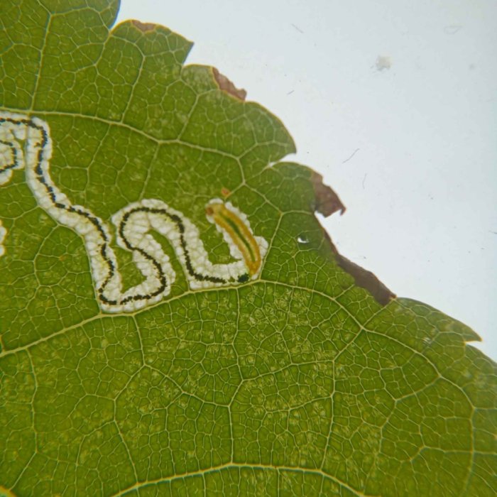
Mine Period Additional: Leaf Mine July and August to October. Larvae are active in July and then from September to October. It overwinters as a pupa in a pale cocoon on the ground.
Mine ID Difficulty:
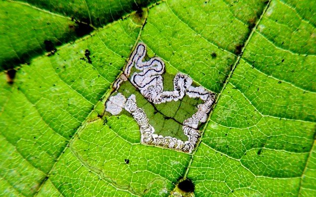
Mine Type/s: Gallery
Mine Feeding Method/s: Not Recorded
Mine Comment: The egg is found on the underside of the leaf. The larvae create a highly contorted, gradually widening corridor mine in the leaves of Tilia species (lime trees). The mine is often initially only on the underside of the leaf, and the frass (excrement) is deposited variably, sometimes in a narrow central line or widely dispersed. The larvae is yellow with a pale brown head. The gut line is green.


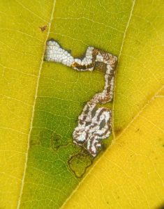
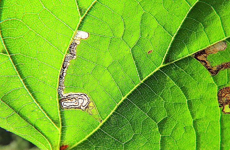


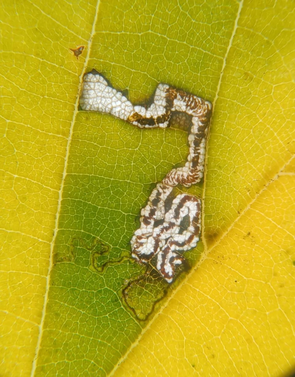
Image Gallery
Distribution Map for Stigmella tiliae
↳ 6 from After 2025
↳ 4 from 2020 - 2024
↳ 3 from Before 2020
If the Map Layers function fails, just refresh the page and it should be OK after. Use the +- zoom on the top left, or on a tablet, use two fingers to zoom. Remember, the last layer you ticked is the one which displays the popup information - they sit on top of each other - de-select then re-select, to see the popup values.
Bedrock Geology ** indirectly affects moth distribution by influencing the type of habitat and food plants available in an area. In turn, this may affect the types of moths that can thrive, or where they can most likely be found.
NBN Atlas UK Distribution for – Stigmella tiliae
⚠️ Please wait for the map to load fully – do not click the link shown.
Note – the NBN Atlas datasets are listed in the map below and vary in their currency (uptodateness) – however,
the map does give a general indication of the moth's distribution across the UK.
Monthly Records By Year:
Stigmella tiliae
( data includes both Larvae and Adult Stages )
Monthly Counts By Year: Stigmella tiliae
( data is based on 'Adult' stage records only. )
First/Last Recorded Dates: Stigmella tiliae
Adult-only & Anything [Larvae, Pupae, Adult, Mines]
Shading shows moth presence between dates
Click the colour discs below to Select/De-select as Required
Recordings By Year: Stigmella tiliae
( All data includes both Larvae and Adult Stages )
Annual Growth Rate (AGR): Stigmella tiliae
AGR: 2.41% | Total % Change: 50%
CUSUM Analysis: Stigmella tiliae
Counts for the current year (2025) are pro-rated based on data available up to month 9 (September) to provide a full-year equivalent.
What the Y-axis "Cumulative Deviation" means: Cumulative Deviation shows the running total of how each year’s moth population count differs from the long-term average. i
Hectad (10kmx10km) Coverage: Stigmella tiliae
( data includes both Larvae and Adult Stages )
Flight Periods – Indicative –vs– Recorded Data
Stigmella tiliae
Stigmella tiliae
( data includes Adult Stage only )
Flight Period chart – the grey hatched area above, which can cross one or more months, pictorially represents the best guess we have for this moth's flight periods [month/s]. The coloured lines represent the actual months seen in flight, from site observation records received between 2020-2025.
Mine Periods – Indicative –vs– Recorded Data
Stigmella tiliae
Stigmella tiliae
( data includes both Larvae and Adult Stages )
Mine Period chart – the grey hatched area above, which can cross one or more months, pictorially represents the best guess we have for this moth's mine periods [month/s]. The coloured lines represent the actual months seen mining, from site observation records received between 2020-2025.
Records Behind the Map and Charts - Stigmella tiliae – 13 records available
Listed by Year - descending - scroll across to see all table columns
| Site Name | Tetrad | Date | Count | Stage | Source |
|---|---|---|---|---|---|
| Sunnydale LNR | SK33G | 06/10/2025 | 3 | mine | vc57_irecords_extract |
| Sunnydale LNR | SK33G | 04/10/2025 | 1 | mine | vc57_irecords_extract |
| Sunnydale LNR | SK33G | 03/10/2025 | 1 | mine | vc57_irecords_extract |
| Markham Vale South Tip | SK47K | 01/10/2025 | 1 | mine | vc57_irecords_extract |
| DWT Wyver Lane | SK34P | 13/08/2025 | 1 | mine (empty) | vc57_irecords_extract |
| DWT Wyver Lane | SK34P | 06/08/2025 | 2 | mine (empty) | vc57_irecords_extract |
| DWT Wyver Lane | SK34P | 12/09/2024 | 2 | mine (empty) | vc57_irecords_extract |
| DWT Wyver Lane | SK34P | 04/09/2024 | 2 | mine (empty) | vc57_irecords_extract |
| Calke Park | SK32R | 07/10/2023 | 1 | Mine | vc57_irecords_extract |
| Rosliston Forestry Centre | SK21N | 17/08/2023 | 1 | mine (empty) | vc57_irecords_extract |
| Grange Wood | SK21S | 13/09/2018 | 1 | Mine | vc57_irecords_extract |
| Calke Park | SK32L | 25/10/2008 | 1 | Mine | vc57_irecords_extract |
| Calke Park,Ticknall | SK32L | 25/10/2008 | 1 | Larval Mine | vc57_danes_bc_data |