

 – click for Adult Macro Verification Guidelines
 – Rare / Uncommon / Scarce
Confusion Species: Small Emerald
Forewing: 11-12mm


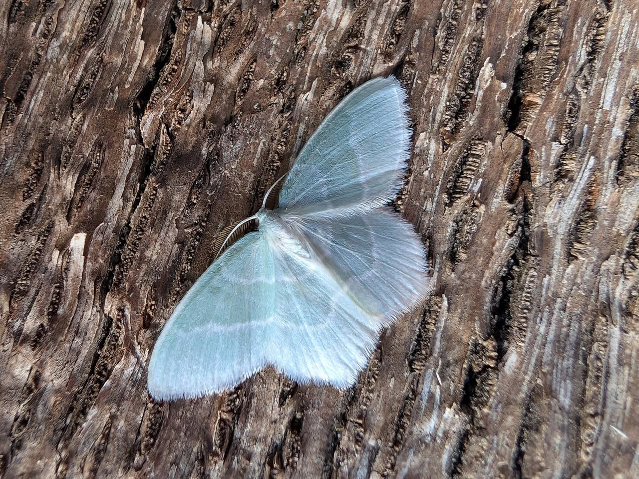

Image Gallery


Temporal Distribution Chart
Adults: (between 1894 - 2026)
Distribution Map for Jodis lactearia
↳ 1 from 2026+
↳ 4 from 2020 - 2025
↳ 86 from Before 2020
If the Map Layers function fails, just refresh the page and it should be OK after. Use the +- zoom on the top left, or on a tablet, use two fingers to zoom. Remember, the last layer you ticked is the one which displays the popup information - they sit on top of each other - de-select then re-select, to see the popup values.
Bedrock Geology ** indirectly affects moth distribution by influencing the type of habitat and food plants available in an area. In turn, this may affect the types of moths that can thrive, or where they can most likely be found.
NBN Atlas UK Distribution for – Jodis lactearia
⚠️ Please wait for the map to load fully – do not click the link shown.
Note – the NBN Atlas datasets are listed in the map below and vary in their currency (uptodateness) – however,
the map does give a general indication of the moth's distribution across the UK.
Monthly Records By Year:
Jodis lactearia
( data includes both Larvae and Adult Stages )
Monthly Counts By Year:
Jodis lactearia
( data is based on 'Adult' stage records only )
First/Last Recorded Dates: Jodis lactearia
Adult-only & Anything [Larvae, Pupae, Adult, Mines]
Shading shows moth presence between dates
Click the colour discs below to Select/De-select as Required
Recordings By Year: Jodis lactearia
( All data includes both Larvae and Adult Stages )
Annual Growth Rate (AGR): Jodis lactearia
AGR: 0% | Total % Change: 0%
Hectad (10kmx10km) Coverage: Jodis lactearia
( data includes both Larvae and Adult Stages )
Flight Periods – Indicative –vs– Recorded Data
Jodis lactearia
Jodis lactearia
Flight Period chart – the grey hatched area above, which can cross one or more months, pictorially represents the best guess we have for this moth's flight periods [month/s]. The coloured lines represent the actual months seen in flight, from site observation records received between 2020-2026.
Records Behind the Map and Charts - Jodis lactearia – 91 records available
Listed by Year - descending - scroll across to see all table columns
| Site Name | Tetrad | Date | Count | Stage | Recorder | Source | RecordKey |
|---|---|---|---|---|---|---|---|
| Sandiacre, Derbyshire | SK43S | 30/05/2026 | 1 | adult | Buxton, Paul | vc57_irecords_extract | iBRC53084700 |
| Melbourne, Derbyshire | SK32X | 01/07/2025 | 1 | Adult | Davison, Tony | vc57_irecords_extract | iBRC42986601 |
| Findern, Derbyshire, DEAZ | SK33A | 19/07/2021 | 1 | Adult | Hallam, Brian and Jean | vc57_irecords_extract | iBRC35165426 |
| Marlborough Road, Long Eaton, Derbys | SK43X | 04/07/2020 | 1 | Adult | Bryce, Marion | vc57_irecords_extract | iBRC15001747 |
| Nottingham NGFY, UK | SK43V | 02/06/2020 | 1 | Adult | Arctic | vc57_irecords_extract | iBRC32190522 |
| Greenwood Centre, Toton | SK43X | 23/07/2016 | 2 | Adult | Bryce, Marion | vc57_irecords_extract | iBRC3729387 |
| Backgarden Marehay | SK34Z | 18/06/2016 | 1 | Adult | Thorpe, Steve | vc57_irecords_extract | iBRC33504600 |
| Shirland - Hallfieldgate Lane | SK35Z | 10/06/2016 | 1 | Adult | Mahadevan, Nikki | vc57_irecords_extract | iBRC35028536 |
| Welbeck Drive, Wingerworth | SK36T | 09/06/2016 | 1 | Adult | B.J.N. Hill | vc57_danes_bc_data | LC000334001WPL6H |
| Shirland - Hallfieldgate Lane | SK35Z | 07/06/2016 | 1 | Adult | Mahadevan, Nikki | vc57_irecords_extract | iBRC35028503 |
| Shirland-Hallfieldgate Lane | SK35Z | 23/06/2015 | 1 | Adult | Mahadevan, Nikki | vc57_irecords_extract | iBRC35070223 |
| Shirland - Hallfieldgate Lane | SK35Z | 07/06/2014 | 1 | Adult | Mahadevan, Nikki | vc57_irecords_extract | iBRC36749076 |
| Hallfieldgate Lane, Shirland, Alfreton | SK35Z | 07/06/2014 | 1 | Adult | N. Mahadevan | vc57_danes_bc_data | LC000334001OLEB3 |
| Hallfieldgate Lane, Shirland, Alfreton | SK35Z | 07/06/2014 | 1 | Adult | N. Mahadevan | vc57_danes_bc_data | LC000334001WP2D7 |
| Lancaster Ave,Sandiacre | SK43S | 18/06/2013 | 1 | Adult | I.M. Viles | vc57_danes_bc_data | LC000334001OKAQI |
| Welbeck Drive, Wingerworth | SK36T | 17/06/2013 | 1 | Adult | B.J.N. Hill | vc57_danes_bc_data | LC000334001WOU2E |
| Chaddesden Wood, Chaddesden, Derby | SK33Z | 27/07/2012 | 1 | Adult | BUDWORTH, Mr D., PATRICK, Mr P., SEWELL, Mr B.G., | vc57_danes_bc_data | LC000334001OKELD |
| Welbeck Drive,Wingerworth | SK36T | 28/06/2012 | 1 | Adult | B.J.N. Hill | vc57_danes_bc_data | LC000334001OK90F |
| Not given | SK34M | 21/06/2012 | 1 | Adult | Ball, Mick | vc57_irecords_extract | iBRC109835 |
| Nether Close, Duffield | SK34M | 20/06/2012 | 1 | Adult | VC57 Derbyshire Recorder | vc57_danes_bc_data | LC000334001OL6EV |
| The Hollies,Station Rd,Darley Dale | SK26R | 07/07/2011 | 1 | Adult | Roddis, Simon | vc57_danes_bc_data | LC000334001OL1OQ |
| The Hollies,Holly St,Stapenhill,Burton on Trent | SK22K | 26/06/2011 | 1 | Adult | P. Patrick | vc57_danes_bc_data | LC000334001OL11T |
| Meynell Langley,Kirk Langley | SK23Z | 04/06/2011 | 1 | Adult | WARD, Mr N.J., CLARKE, Mr D.A., MILLAR, Mr J.C.G., | vc57_danes_bc_data | LC000334001OJRQ1 |
| The Hollies,Holly St,Stapenhill,Burton on Trent | SK22K | 04/07/2009 | 4 | Adult | P. Patrick | vc57_danes_bc_data | LC000334001OKOK9 |
| The Hollies,Holly St,Stapenhill,Burton on Trent | SK22K | 02/07/2009 | 1 | Adult | P. Patrick | vc57_danes_bc_data | LC000334001OKOEU |
| The Hollies,Holly St,Stapenhill,Burton on Trent | SK22K | 30/06/2009 | 2 | Adult | P. Patrick | vc57_danes_bc_data | LC000334001OK1SK |
| Stainsby Park,Glapwell | SK46S | 02/06/2008 | 1 | Adult | M.E. Bradley | vc57_danes_bc_data | LC000334001OKJQC |
| Lowes Hill,Ripley | SK35V | 14/07/2007 | 1 | Adult | R.A. Wain | vc57_danes_bc_data | LC000334001OKCP6 |
| Lowes Hill,Ripley | SK35V | 12/07/2007 | 2 | Adult | R.A. Wain | vc57_danes_bc_data | LC000334001OKHJW |
| Mercaston Marsh, Mercaston, Brailsford | SK24R | 17/06/2006 | 1 | Adult | Dave Budworth;N.J. Ward | vc57_danes_bc_data | LC000334001OIF9T |
| Drayton Ave,Mackworth,Derby | SK33D | 12/06/2006 | 1 | Adult | W. Hurst | vc57_danes_bc_data | LC000334001OJC6K |
| Drayton Ave,Mackworth,Derby | SK33D | 12/06/2006 | 1 | Adult | W. Hurst | vc57_danes_bc_data | LC000334001WP6N9 |
| Ticknall Limeyards, Calke Park | SK32R | 17/06/2005 | 1 | Adult | Soar, Will | vc57_irecords_extract | iBRC34678452 |
| Ticknall Limeyards,Ticknall | SK32R | 17/06/2005 | 1 | Adult | Dave Budworth;A. Davison;N.J. Ward;W. Soar | vc57_danes_bc_data | LC000334001OJ8TL |
| Dimminsdale NR, Calke | SK32Q | 03/06/2003 | 1 | Adult | BUDWORTH, Mr D., WILLIAMS, Mr M.J., WILLIAMS, Mrs | vc57_danes_bc_data | LC000334001OIF4V |
| Hilton NR, Hilton, Etwall | SK23K | 14/06/2002 | 1 | Adult | I. Travers-Ayre;I.M. Viles | vc57_danes_bc_data | LC000334001OJ2O5 |
| Hilton NR, Hilton, Etwall | SK23K | 08/06/2002 | 1 | Adult | I. Travers-Ayre;I.M. Viles | vc57_danes_bc_data | LC000334001OI44J |
| Church St,Holloway,Matlock | SK35I | 02/07/2001 | 1 | Adult | F. Harrison | vc57_danes_bc_data | LC000334001OJ2AC |
| Lang Rd, Alvaston, Derby | SK33R | 30/06/1996 | 1 | Adult | VC57 Derbyshire Recorder | vc57_danes_bc_data | LC000334001OIZPS |
| Lang Rd, Alvaston, Derby | SK33R | 28/06/1993 | 1 | Adult | VC57 Derbyshire Recorder | vc57_danes_bc_data | LC000334001OIX7A |
| Lang Rd, Alvaston, Derby | SK33R | 28/06/1993 | 1 | Adult | I. Travers-Ayre | vc57_danes_bc_data | LC000334001WPX6S |
| Gallows Inn Close,Ilkeston | SK44Q | 31/05/1993 | 1 | Adult | A.D. Price | vc57_danes_bc_data | LC000334001OIWW0 |
| Gallows Inn Close,Ilkeston | SK44Q | 31/05/1993 | 1 | Adult | A.D. Price | vc57_danes_bc_data | LC000334001WP07D |
| Lang Rd, Alvaston, Derby | SK33R | 20/06/1992 | 2 | Adult | VC57 Derbyshire Recorder | vc57_danes_bc_data | LC000334001OI1EI |
| Lang Rd, Alvaston, Derby | SK33R | 20/06/1992 | 2 | Adult | A. Braddock;I. Travers-Ayre | vc57_danes_bc_data | LC000334001WQAEA |
| Lang Rd, Alvaston, Derby | SK33R | 16/06/1992 | 1 | Adult | VC57 Derbyshire Recorder | vc57_danes_bc_data | LC000334001OIW1R |
| Lang Rd, Alvaston, Derby | SK33R | 16/06/1992 | 1 | Adult | A. Braddock;I. Travers-Ayre | vc57_danes_bc_data | LC000334001WP04I |
| Oakerthorpe LNR, Alfreton | SK35X | 12/06/1985 | 1 | Adult | B.L. Statham | vc57_danes_bc_data | LC000334001OIRD5 |
| Shardlow Hall, Shardlow, Long Eaton | SK43F | 25/06/1983 | 1 | Adult | VC57 Derbyshire Recorder | vc57_danes_bc_data | LC000334001OIPQA |
| Shardlow Hall, Shardlow, Long Eaton | SK43F | 25/06/1983 | 1 | Adult | R.H. Dumelow | vc57_danes_bc_data | LC000334001WOOHV |
| Shardlow Hall, Shardlow, Long Eaton | SK43F | 22/06/1983 | 1 | Adult | VC57 Derbyshire Recorder | vc57_danes_bc_data | LC000334001OIAK1 |
| Shardlow Hall, Shardlow, Long Eaton | SK43F | 22/06/1983 | 1 | Adult | R.H. Dumelow | vc57_danes_bc_data | LC000334001WPUZV |
| Crich Chase, Ambergate (site not precise) | SK35L | 28/05/1982 | 1 | Adult | VC57 Derbyshire Recorder | vc57_danes_bc_data | LC000334001OIOH5 |
| Askew Grove, Repton | SK32D | 24/06/1981 | 2 | Adult | D.A. Young | vc57_danes_bc_data | LC000334001OINL6 |
| Carvers Rocks NR, Hartshorne, Swadlincote (site not precise) | SK32G | 12/06/1981 | 1 | Adult | VC57 Derbyshire Recorder | vc57_danes_bc_data | LC000334001OINJ2 |
| Carvers Rocks NR,Hartshorne,Swadlincote | SK32G | 04/07/1979 | 2 | Adult | D.A. Young | vc57_danes_bc_data | LC000334001OHGJK |
| Carvers Rocks NR,Hartshorne,Swadlincote | SK32G | 28/04/1979 | 1 | Adult | D.A. Young | vc57_danes_bc_data | LC000334001OILKZ |
| Carvers Rocks NR,Hartshorne,Swadlincote | SK32G | 20/04/1979 | 1 | Adult | D.A. Young | vc57_danes_bc_data | LC000334001OHGHN |
| Field Close, Hilton, Burton on Trent | SK23K | 22/06/1976 | 1 | Adult | VC57 Derbyshire Recorder | vc57_danes_bc_data | LC000334001OIJSC |
| Askew Grove, Repton | SK32D | 15/06/1976 | 1 | Adult | D.A. Young | vc57_danes_bc_data | LC000334001OHFPD |
| Askew Grove, Repton | SK32D | 15/06/1976 | 1 | Adult | D.A. Young | vc57_danes_bc_data | LC000334001WOR8T |
| Repton (site not precise) | SK32I | 15/06/1976 | 1 | Adult | VC57 Derbyshire Recorder | vc57_danes_bc_data | LC000334001OHFPE |
| Repton (site not precise) | SK32B | 12/06/1976 | 1 | Adult | VC57 Derbyshire Recorder | vc57_danes_bc_data | LC000334001OI9RY |
| Askew Grove, Repton | SK32D | 12/06/1976 | 1 | Adult | D.A. Young | vc57_danes_bc_data | LC000334001OI9RU |
| Askew Grove, Repton | SK32D | 12/06/1976 | 1 | Adult | D.A. Young | vc57_danes_bc_data | LC000334001WOR8P |
| Repton (site not precise) | SK32B | 01/01/1975 | 1 | Adult | [VC57 Recorder] | vc57_danes_bc_data | LC000334001TAGEJ |
| Askew Grove, Repton | SK32D | 01/01/1975 | 1 | Adult | [VC57 Recorder] | vc57_danes_bc_data | LC000334001TAGC0 |
| Repton Shrubs, Repton (site not precise) | SK32B | 23/06/1973 | 1 | Adult | VC57 Derbyshire Recorder | vc57_danes_bc_data | LC000334001OII2Y |
| John St, Clay Cross | SK36W | 22/09/1962 | 1 | Adult | VC57 Derbyshire Recorder | vc57_danes_bc_data | LC000334001OIH0R |
| Harthill, Youlgreave (site not precise) | SK26G | 12/07/1959 | 1 | Adult | VC57 Derbyshire Recorder | vc57_danes_bc_data | LC000334001OHE2R |
| Robin Wood, Ticknall | SK32S | 04/06/1959 | 1 | Adult | VC57 Derbyshire Recorder | vc57_danes_bc_data | LC000334001OHDWM |
| Melton Ave, Littleover, Derby | SK33G | 27/05/1959 | 1 | Adult | VC57 Derbyshire Recorder | vc57_danes_bc_data | LC000334001OHVHN |
| Heath Av, Littleover (home address asumed) | SK33H | 23/07/1956 | 1 | Adult | VC57 Derbyshire Recorder | vc57_danes_bc_data | LC000334001OHDNU |
| Robin Wood, Ticknall | SK32S | 13/06/1956 | 1 | Adult | VC57 Derbyshire Recorder | vc57_danes_bc_data | LC000334001OHVAG |
| Melton Ave, Littleover, Derby | SK33G | 01/01/1956 | 6 | Adult | VC57 Derbyshire Recorder | vc57_danes_bc_data | LC000334001OIDF6 |
| Berry St, Hepthorne Lane | SK46C | 02/07/1953 | 1 | Adult | VC57 Derbyshire Recorder | vc57_danes_bc_data | LC000334001OHV7E |
| Berry St, Hepthorne Lane, North Wingfield | SK46C | 02/07/1953 | 1 | Adult | J.H. Johnson | vc57_danes_bc_data | LC000334001WPQ6E |
| Cowlishaw Wood, Old Tupton | SK36S | 13/06/1953 | 1 | Adult | VC57 Derbyshire Recorder | vc57_danes_bc_data | LC000334001OHDJX |
| Cowlishaw Wood, Old Tupton | SK36S | 13/06/1953 | 1 | Adult | J.H. Johnson | vc57_danes_bc_data | LC000334001WPQ5M |
| Hardwick Wood, Wingerworth (site not precise) | SK36T | 07/06/1953 | 1 | Adult | VC57 Derbyshire Recorder | vc57_danes_bc_data | LC000334001OHDJH |
| Tupton Wood, Old Tupton (site not precise) | SK36X | 22/05/1953 | 1 | Adult | VC57 Derbyshire Recorder | vc57_danes_bc_data | LC000334001OIDDK |
| Repton Shrubs, Repton | SK32B | 01/05/1938 | 1 | Adult | VC57 Derbyshire Recorder | vc57_danes_bc_data | LC000334001OHDH4 |
| Repton Shrubs, Repton | SK32B | 16/06/1936 | 1 | Adult | VC57 Derbyshire Recorder | vc57_danes_bc_data | LC000334001OHDGT |
| Stenson, Willington (site not precise) | SK32J | 01/06/1932 | 1 | Adult | VC57 Derbyshire Recorder | vc57_danes_bc_data | LC000334001OIDA8 |
| Tibshelf (site not precise) | SK46K | 01/01/1921 | 1 | Adult | VC57 Derbyshire Recorder | vc57_danes_bc_data | LC000334001OHDFW |
| Repton (site not precise) | SK32D | 16/06/1917 | 1 | Adult | VC57 Derbyshire Recorder | vc57_danes_bc_data | LC000334001OID7V |
| Repton (site not precise) | SK32D | 23/05/1911 | 1 | Adult | VC57 Derbyshire Recorder | vc57_danes_bc_data | LC000334001OJHID |
| Derby (site not precise) | SK33M | 01/07/1894 | 1 | Adult | VC57 Derbyshire Recorder | vc57_danes_bc_data | LC000334001OLG4E |
| Derby (site not precise) | SK33M | 01/07/1894 | 1 | Adult | F.W.G. Payne | vc57_danes_bc_data | LC000334001WPQ4V |
| Beadsall Moor, Breadsall (site not precise) | SK34R | 01/01/1883 | 1 | Adult | Harpur Crewe;U. Unknown | vc57_danes_bc_data | LC000334001WP37C |
| Beadsall Moor, Breadsall (site not precise) | SK34R | 01/01/1800 | 1 | Adult | VC57 Derbyshire Recorder | vc57_danes_bc_data | LC000334001OLG3W |