

 – click for Adult Macro Verification Guidelines
 – Rare / Uncommon / Scarce
Confusion Species: Lead Belle
Forewing: 15-19mm
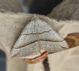


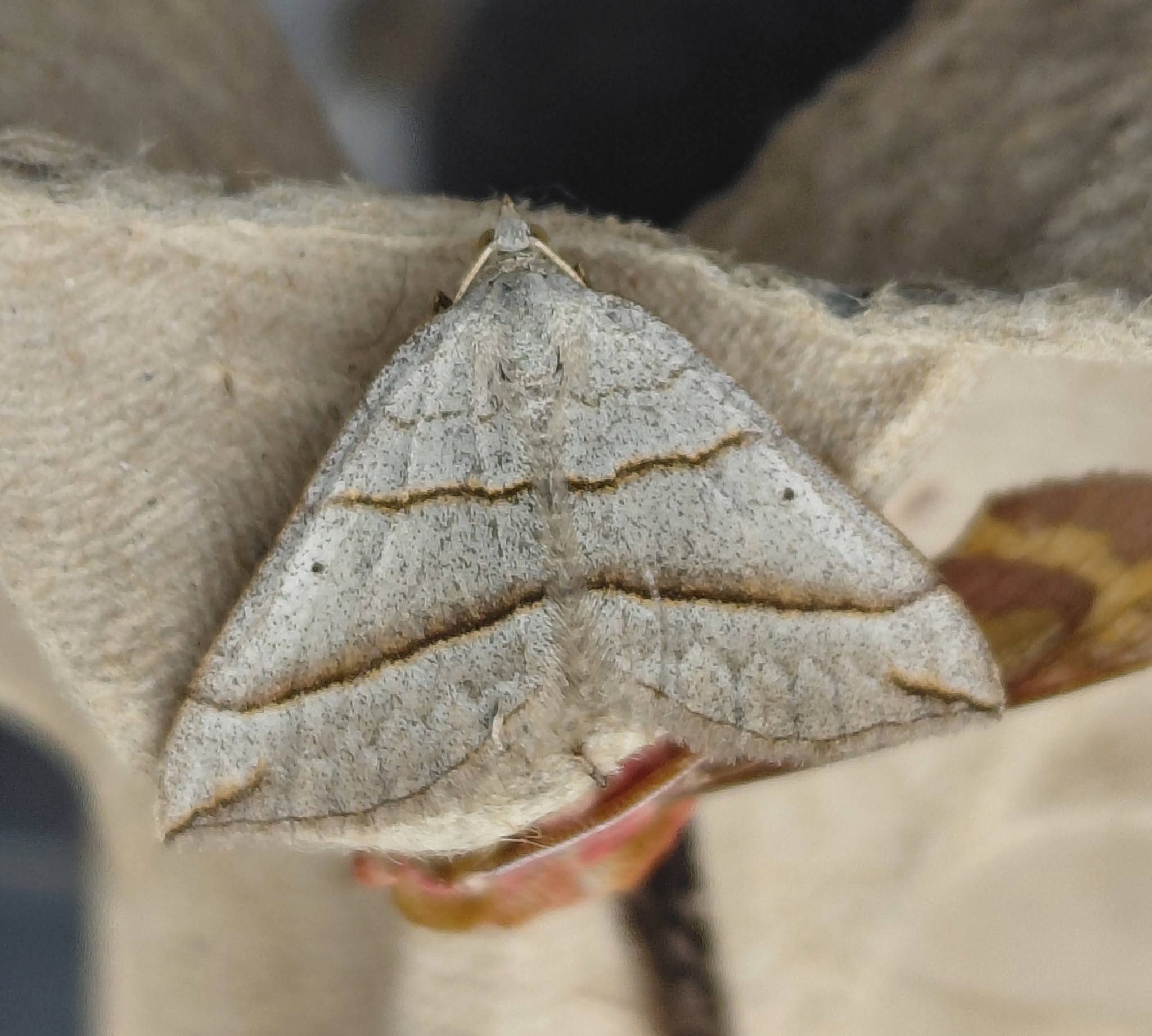


Image Gallery
No gallery images found for this moth.
Temporal Distribution Chart
Adults: (between 1923 - 2013)
Distribution Map for Scotopteryx luridata
↳ from 2026+
↳ from 2020 - 2025
↳ 32 from Before 2020
If the Map Layers function fails, just refresh the page and it should be OK after. Use the +- zoom on the top left, or on a tablet, use two fingers to zoom. Remember, the last layer you ticked is the one which displays the popup information - they sit on top of each other - de-select then re-select, to see the popup values.
Bedrock Geology ** indirectly affects moth distribution by influencing the type of habitat and food plants available in an area. In turn, this may affect the types of moths that can thrive, or where they can most likely be found.
NBN Atlas UK Distribution for – Scotopteryx luridata
⚠️ Please wait for the map to load fully – do not click the link shown.
Note – the NBN Atlas datasets are listed in the map below and vary in their currency (uptodateness) – however,
the map does give a general indication of the moth's distribution across the UK.
Monthly Records By Year:
Scotopteryx luridata
( data includes both Larvae and Adult Stages )
Monthly Counts By Year:
Scotopteryx luridata
( data is based on 'Adult' stage records only )
First/Last Recorded Dates: Scotopteryx luridata
Adult-only & Anything [Larvae, Pupae, Adult, Mines]
Shading shows moth presence between dates
Click the colour discs below to Select/De-select as Required
Recordings By Year: Scotopteryx luridata
( All data includes both Larvae and Adult Stages )
Annual Growth Rate (AGR): Scotopteryx luridata
AGR: 2.62% | Total % Change: 40%
Hectad (10kmx10km) Coverage: Scotopteryx luridata
( data includes both Larvae and Adult Stages )
Flight Periods – Indicative –vs– Recorded Data
Scotopteryx luridata
Scotopteryx luridata
Flight Period chart – the grey hatched area above, which can cross one or more months, pictorially represents the best guess we have for this moth's flight periods [month/s]. The coloured lines represent the actual months seen in flight, from site observation records received between 2020-2026.
Records Behind the Map and Charts - Scotopteryx luridata – 32 records available
Listed by Year - descending - scroll across to see all table columns
| Site Name | Tetrad | Date | Count | Stage | Recorder | Source | RecordKey |
|---|---|---|---|---|---|---|---|
| Not given | SK36H | 10/08/2013 | 1 | Adult | Sinnott, Tony | vc57_irecords_extract | iBRC432419 |
| Wragg's Quarry, Beeley Moor | SK26Y | 15/07/2013 | 1 | Adult | A. Butler;B.L. Statham | vc57_danes_bc_data | LC000334001OJWY9 |
| Wragg's Quarry, Beeley Moor, Beeley | SK26Y | 15/07/2013 | 1 | Adult | A. Butler;B.L. Statham | vc57_danes_bc_data | LC000334001WPNUO |
| Longstone Edge,Great Longstone | SK17W | 10/07/2013 | 2 | Adult | Barnacle, Brian | vc57_danes_bc_data | LC000334001OLBNY |
| Longstone Edge, Great Longstone | SK17W | 10/07/2013 | 2 | Adult | B. Barnacle;K. Barnacle | vc57_danes_bc_data | LC000334001WPMP5 |
| Longstone Edge,Great Longstone | SK17W | 05/07/2012 | 1 | Adult | Barnacle, Brian | vc57_danes_bc_data | LC000334001OL6XT |
| Longstone Edge, Great Longstone | SK17W | 05/07/2012 | 1 | Adult | B. Barnacle;K. Barnacle | vc57_danes_bc_data | LC000334001WQHKO |
| Longstone Edge,Great Longstone | SK27B | 29/06/2011 | 1 | Adult | D.A. Clarke | vc57_danes_bc_data | LC000334001OK6KO |
| Shipley Park,Ilkeston | SK44H | 26/06/2011 | 1 | Adult | D.A. Clarke | vc57_danes_bc_data | LC000334001OL13P |
| Longstone Edge,Great Longstone | SK17W | 31/05/2011 | 1 | Adult | D.A. Clarke | vc57_danes_bc_data | LC000334001OJRLF |
| School Close,Parkway Gardens,Darley Dale | SK26R | 01/07/2000 | 1 | Adult | A. Butler | vc57_danes_bc_data | LC000334001OHOAC |
| School Close,Parkway Gardens,Darley Dale | SK26R | 01/07/2000 | 1 | Adult | A. Butler | vc57_danes_bc_data | LC000334001WQ5UL |
| Ladycroft Ave,Buxton | SK07S | 13/07/1996 | 1 | Adult | VC57 Derbyshire Recorder | vc57_danes_bc_data | LC000334001OI2N2 |
| Ladycroft Ave, Buxton | SK07S | 13/07/1996 | 1 | Adult | Steve Orridge;B. Elliott | vc57_danes_bc_data | LC000334001WQ45I |
| nr West Hallam | SK44L | 24/07/1995 | 1 | Adult | T. Duro | vc57_danes_bc_data | LC000334001OIZ5P |
| nr West Hallam | SK44L | 24/07/1995 | 1 | Adult | T. Duro | vc57_danes_bc_data | LC000334001WQ433 |
| Leash Fen Heights | SK27X | 08/07/1995 | 1 | Adult | Whiteley, Derek | vc57_irecords_extract | iBRC3039902 |
| Leash Fen Heights, Baslow | SK27X | 08/07/1995 | 1 | Adult | D. Whiteley | vc57_danes_bc_data | LC000334001OIYYI |
| Leash Fen Heights, Baslow | SK27X | 08/07/1995 | 1 | Adult | D.E. Whiteley | vc57_danes_bc_data | LC000334001WQ5HJ |
| Parkway, New Mills | SK08D | 20/06/1989 | 1 | Adult | J. Potts | vc57_danes_bc_data | LC000334001OITKD |
| Parkway, New Mills | SK08D | 15/07/1987 | 1 | Adult | J. Potts | vc57_danes_bc_data | LC000334001OISYQ |
| Parkway, New Mills | SK08D | 09/07/1987 | 1 | Adult | J. Potts | vc57_danes_bc_data | LC000334001OHJSQ |
| Matlock (Teacher Training College) | SK36A | 10/07/1983 | 1 | Adult | VC57 Derbyshire Recorder | vc57_danes_bc_data | LC000334001OHIEL |
| Drummond Rd, Ilkeston | SK44R | 07/08/1980 | 1 | Adult | T. Duro | vc57_danes_bc_data | LC000334001OIMYT |
| Drummond Rd, Ilkeston | SK44R | 27/07/1980 | 1 | Adult | T. Duro | vc57_danes_bc_data | LC000334001OHH09 |
| Upper Booth, Edale | SK08X | 03/07/1980 | 1 | Adult | VC57 Derbyshire Recorder | vc57_danes_bc_data | LC000334001OIMH3 |
| Askew Grove, Repton | SK32D | 20/06/1973 | 1 | Adult | D.A. Young | vc57_danes_bc_data | LC000334001OHWDI |
| Newbold Drive, Chesterfield | SK37R | 14/06/1964 | 1 | Adult | VC57 Derbyshire Recorder | vc57_danes_bc_data | LC000334001OIH75 |
| Manners Wood,Bakewell | SK26J | 18/06/1960 | 1 | Adult | VC57 Derbyshire Recorder | vc57_danes_bc_data | LC000334001OIGRQ |
| Newbold Ave, Chesterfield | SK37R | 19/07/1958 | 1 | Adult | VC57 Derbyshire Recorder | vc57_danes_bc_data | LC000334001OIFQH |
| Cutthorpe, Chesterfield | SK37L | 02/07/1951 | 1 | Adult | VC57 Derbyshire Recorder | vc57_danes_bc_data | LC000334001OJHMD |
| Mickleover, Derby (site not precise) | SK33C | 21/07/1923 | 1 | Adult | H.C. Hayward | vc57_danes_bc_data | LC000334001WPZB2 |