

 – click for Adult Macro Verification Guidelines
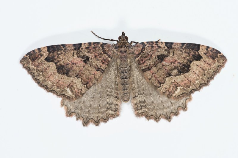
 – Rare / Uncommon / Scarce
Confusion Species: Scarce Tissue
Forewing: 19-22mm


Image Gallery
Temporal Distribution Chart
Adults: (between 1957 - 2026) | Immatures: (between 1970 - 2014)
Distribution Map for Triphosa dubitata
↳ 2 from 2026+
↳ 29 from 2020 - 2025
↳ 48 from Before 2020
If the Map Layers function fails, just refresh the page and it should be OK after. Use the +- zoom on the top left, or on a tablet, use two fingers to zoom. Remember, the last layer you ticked is the one which displays the popup information - they sit on top of each other - de-select then re-select, to see the popup values.
Bedrock Geology ** indirectly affects moth distribution by influencing the type of habitat and food plants available in an area. In turn, this may affect the types of moths that can thrive, or where they can most likely be found.
NBN Atlas UK Distribution for – Triphosa dubitata
⚠️ Please wait for the map to load fully – do not click the link shown.
Note – the NBN Atlas datasets are listed in the map below and vary in their currency (uptodateness) – however,
the map does give a general indication of the moth's distribution across the UK.
Monthly Records By Year:
Triphosa dubitata
( data includes both Larvae and Adult Stages )
Monthly Counts By Year:
Triphosa dubitata
( data is based on 'Adult' stage records only )
First/Last Recorded Dates: Triphosa dubitata
Adult-only & Anything [Larvae, Pupae, Adult, Mines]
Shading shows moth presence between dates
Click the colour discs below to Select/De-select as Required
Recordings By Year: Triphosa dubitata
( All data includes both Larvae and Adult Stages )
Annual Growth Rate (AGR): Triphosa dubitata
AGR: 2.81% | Total % Change: 100%
Hectad (10kmx10km) Coverage: Triphosa dubitata
( data includes both Larvae and Adult Stages )
Flight Periods – Indicative –vs– Recorded Data
Triphosa dubitata
Triphosa dubitata
Flight Period chart – the grey hatched area above, which can cross one or more months, pictorially represents the best guess we have for this moth's flight periods [month/s]. The coloured lines represent the actual months seen in flight, from site observation records received between 2020-2026.
Records Behind the Map and Charts - Triphosa dubitata – 79 records available
Listed by Year - descending - scroll across to see all table columns
| Site Name | Tetrad | Date | Count | Stage | Recorder | Source | RecordKey |
|---|---|---|---|---|---|---|---|
| Cressbrook Tunnel , Monsal Trail ,Derbyshire | SK17R | 23/03/2026 | 1 | Adult | Morris, Sid | vc57_irecords_extract | iBRC50722907 |
| Litton Tunnel Monsal Trail derbyshire | SK17R | 23/03/2026 | 3 | Adult | Morris, Sid | vc57_irecords_extract | iBRC50722945 |
| Headstone Tunnel , Monsal Trail , Derbyshire | SK17V | 22/12/2025 | 1 | Adult | Morris, Sid | vc57_irecords_extract | iBRC48272641 |
| Ible Wood, Via Gellia, Ible CP | SK25N | 02/12/2025 | 6 | Adult | Alder, Jim | vc57_irecords_extract | iBRC47492566 |
| Monsal Trail , Cressbrook Tunnel | SK17R | 24/11/2025 | 1 | Adult | Morris, Sid | vc57_irecords_extract | iBRC46779022 |
| Monsal Trail , Litton Tunnel | SK17R | 24/11/2025 | 1 | Adult | Morris, Sid | vc57_irecords_extract | iBRC46779039 |
| Monsal Trail Derbyshire | SK17R | 06/10/2025 | 9 | Adult | Morris, Sid | vc57_irecords_extract | iBRC45817497 |
| Monsal Trail Derbyshire | SK17R | 06/10/2025 | 9 | Adult | Morris, Sid | vc57_irecords_extract | iBRC45817527 |
| Monsal Trail Derbyshire | SK17R | 06/10/2025 | 16 | Adult | Morris, Sid | vc57_irecords_extract | iBRC45817662 |
| Monsal Head | SK17V | 06/10/2025 | 2 | Adult | Morris, Sid | vc57_irecords_extract | iBRC45817453 |
| Longdendale, Torside Clough, Crags at m | SK09T | 22/07/2025 | 1 | Adult | Heintzen, Christian | vc57_irecords_extract | iBRC43980565 |
| Monsal Trail Derbyshire | SK17R | 10/03/2025 | 6 | Adult | Morris, Sid | vc57_irecords_extract | iBRC40397052 |
| Crabtree Wood mine, Barlborough CP | SK47Z | 02/02/2025 | 6 | Adult | Alder, Jim | vc57_irecords_extract | iBRC40118095 |
| Monsal Trail Tunnels , Derbyshire | SK17Q | 19/01/2025 | 2 | Adult | Morris, Sid | vc57_irecords_extract | iBRC40029257 |
| Great Longstone | SK17R | 25/11/2024 | 9 | Adult | Morris, Sid | vc57_irecords_extract | iBRC39265852 |
| Monsal trail tunnels. | SK17R | 25/11/2024 | 9 | Adult | Morris, Sid | vc57_irecords_extract | iBRC39265860 |
| Longdendale, Wildboar Clough Woodland | SK09U | 01/11/2024 | 1 | Adult | Heintzen, Christian | vc57_irecords_extract | iBRC39768235 |
| Poole's Cavern | SK07L | 24/04/2024 | 1 | Adult | Bell, Steven | vc57_irecords_extract | iBRC40548385 |
| Hulme End, Buxton SKHQ, UK | SK15J | 09/01/2024 | 1 | Adult | Moores, Stephen | vc57_irecords_extract | iBRC34501218 |
| Odin Mine, Castleton, Derbyshire | SK18G | 21/12/2023 | 1 | Adult | Denham, Callan | vc57_irecords_extract | iBRC34319778 |
| Longdendale, Wildboar Clough | SK09U | 07/10/2023 | 2 | Adult | Heintzen, Christian | vc57_irecords_extract | iBRC36337619 |
| Stoney Middleton | SK27H | 19/09/2023 | 5 | Adult | Arthur, Chris | vc57_irecords_extract | iBRC33083357 |
| Ladycroft Ave | SK07S | 03/09/2023 | 1 | Adult | Orridge, Steve | vc57_irecords_extract | iBRC35075716 |
| Stonebroom | SK45E | 15/08/2023 | 1 | Adult | Bradley, Jonathan | vc57_irecords_extract | iBRC35419134 |
| Headstone tunnel , Monsal Dale , Derbyshire | SK17V | 12/03/2023 | 2 | Adult | Morris, Sid | vc57_irecords_extract | iBRC29635160 |
| Derbyshire , Monsal `Headstone Tunnel` and `Cressbrook Tunnel` location of Brown Long-eared Bat. | SK17R | 23/01/2023 | 1 | Adult | Morris, Sid | vc57_irecords_extract | iBRC29225745 |
| Buxton SK, UK | SK07S | 18/07/2022 | 1 | Adult | Orridge, Steve | vc57_irecords_extract | iBRC27320149 |
| Ferneydale Avenue | SK07Q | 27/03/2022 | 1 | Adult | Wakefield, Rowan | vc57_irecords_extract | iBRC34939263 |
| Crowden, Glossop SKHZ, UK | SK09U | 18/04/2021 | 1 | Adult | Hazza | vc57_irecords_extract | iBRC52149073 |
| Chapel House, Middleton by Youlgreave | SK16W | 28/04/2020 | 1 | adult | ASTON, Mr D. | Danes_2019-2021 | 810 |
| Middleton by Youlgreave | SK16W | 27/04/2020 | 1 | Adult | Aston, Doug | vc57_irecords_extract | iBRC39275701 |
| Findern, Derbyshire, DEAZ | SK33A | 27/08/2019 | 1 | Adult | Hallam, Brian and Jean | vc57_irecords_extract | iBRC35161892 |
| Belper | SK34N | 20/04/2019 | 1 | Adult | Evans, Dave | vc57_irecords_extract | iBRC35298338 |
| Derbyshire, UK | SK15N | 27/08/2018 | 1 | Adult | Moores, Stephen | vc57_irecords_extract | iBRC9994444 |
| [sensitive record, location hidden] | SK36L | 19/08/2017 | 1 | Adult | Alder, Jim | vc57_irecords_extract | iBRC5624950! |
| Crabtree Wood (old mine), Pebley, Barlborough | SK47Z | 21/01/2017 | 9 | Adult | J. Alder | vc57_danes_bc_data | LC000334001WP7LN |
| Wolfscote Dale | SK15J | 22/11/2015 | 1 | Adult | Price, Robert | vc57_irecords_extract | iBRC2830038 |
| Biggin Dale | SK15N | 22/11/2015 | 5 | Adult | Price, Robert | vc57_irecords_extract | iBRC2829994 |
| Pleasley Pit (run-offs), Pleasley | SK46X | 09/05/2014 | 1 | Larvae | C. Stubbs | vc57_danes_bc_data | LC000334001OLE6F |
| Ladycroft Ave | SK07S | 06/10/2013 | 1 | Adult | Orridge, Steve | vc57_irecords_extract | iBRC40991815 |
| Hartington (station quarry) | SK16K | 27/09/2013 | 1 | Adult | S. Bell | vc57_danes_bc_data | LC000334001OKBXF |
| Oaks Barn Cottage, Monyash Rd, Over Haddon, Bakewell | SK26D | 11/09/2010 | 1 | Adult | D.A. Clarke | vc57_danes_bc_data | LC000334001OKXU8 |
| Dronfield Woodhouse | SK37J | 18/04/2010 | 1 | Adult | Williamson, Andy | vc57_irecords_extract | iBRC45355977 |
| Buxton SK, UK | SK07S | 19/09/2008 | 1 | Adult | Orridge, Steve | vc57_irecords_extract | iBRC22321674 |
| Buxton SK, UK | SK07S | 19/09/2008 | 1 | Adult | Orridge, Steve | vc57_irecords_extract | iBRC22503459 |
| Buxton SK, UK | SK07S | 19/09/2008 | 1 | Adult | Orridge, Steve | vc57_irecords_extract | iBRC23020131 |
| Ladycroft Ave,Buxton | SK07S | 07/07/2008 | 1 | Adult | Orridge, Steve | vc57_danes_bc_data | LC000334001OKKE7 |
| Dovedale | SK15K | 10/08/2007 | 2 | Adult | BUDWORTH, Mr D., SOAR, Mr W., DAWSON, Mr M.E., WHI | vc57_danes_bc_data | LC000334001OKCRC |
| Clough Wood | SK26Q | 28/08/2006 | 1 | Adult | Roddis, Simon | vc57_danes_bc_data | LC000334001OJFNY |
| Hopton Wood Quarry,Cromford | SK25T | 07/06/2006 | 14 | Larvae | B.L. Statham | vc57_danes_bc_data | LC000334001OJBWN |
| Carvers Rocks, Hartshorne, Swadlincote | SK32G | 12/05/2006 | 1 | Adult | Dave Budworth;N. Topliss | vc57_danes_bc_data | LC000334001OJBMD |
| Carvers Rocks, Hartshorne, Swadlincote | SK32G | 12/05/2006 | 1 | Adult | Dave Budworth;N. Topliss | vc57_danes_bc_data | LC000334001WP6MB |
| Armitage Drive, Long Eaton | SK53B | 17/07/2002 | 1 | Adult | VC57 Derbyshire Recorder | vc57_danes_bc_data | LC000334001OHOQ2 |
| Beeley Moor, Beeley | SK26Y | 25/08/2001 | 1 | Adult | B.L. Statham | vc57_danes_bc_data | LC000334001OI40N |
| Beeley Moor, Beeley | SK26Y | 25/08/2001 | 1 | Adult | B.L. Statham | vc57_danes_bc_data | LC000334001WPF01 |
| Miller's Dale | SK17L | 14/08/1994 | 1 | Adult | VC57 Derbyshire Recorder | vc57_danes_bc_data | LC000334001OHMKZ |
| Lang Rd, Alvaston, Derby | SK33R | 23/07/1992 | 1 | Adult | VC57 Derbyshire Recorder | vc57_danes_bc_data | LC000334001OI1J0 |
| Pond House, Mapperley Res, Ilkeston | SK44G | 07/05/1988 | 1 | Adult | T. Duro | vc57_danes_bc_data | LC000334001OIE4L |
| Pond House, Mapperley Res, Ilkeston | SK44G | 07/05/1988 | 1 | Adult | T. Duro | vc57_danes_bc_data | LC000334001WOQ7U |
| Dovedale (site not precise) | SK15K | 02/06/1984 | 1 | Adult | VC57 Derbyshire Recorder | vc57_danes_bc_data | LC000334001OIQG8 |
| Matlock (Teacher Training College) | SK36A | 04/10/1983 | 1 | Adult | VC57 Derbyshire Recorder | vc57_danes_bc_data | LC000334001OIQF4 |
| Matlock (Teacher Training College) | SK36A | 24/05/1983 | 1 | Adult | VC57 Derbyshire Recorder | vc57_danes_bc_data | LC000334001OHYRN |
| Matlock (Teacher Training College) | SK36A | 01/06/1982 | 1 | Adult | VC57 Derbyshire Recorder | vc57_danes_bc_data | LC000334001OIOJA |
| Threepieces, Veron Lane, Kelstedge, Ashover | SK36G | 14/05/1980 | 3 | Adult | VC57 Derbyshire Recorder | vc57_danes_bc_data | LC000334001OIM6K |
| Via Gellia (site not precise),Cromford | SK25N | 06/06/1977 | 1 | Adult | VC57 Derbyshire Recorder | vc57_danes_bc_data | LC000334001OIKA6 |
| Via Gellia (site not precise), Cromford | SK25N | 06/06/1977 | 1 | Adult | B. Elliott | vc57_danes_bc_data | LC000334001WPWQV |
| Hopton Wood Quarry, Via Gelia | SK25S | 30/05/1975 | 1 | Larvae | VC57 Derbyshire Recorder | vc57_danes_bc_data | LC000334001OHFE6 |
| Hopton Wood (site not precise) | SK25M | 26/05/1974 | 1 | Larvae | VC57 Derbyshire Recorder | vc57_danes_bc_data | LC000334001OHF6I |
| Rupert St, Pilsley, Tibshelf | SK46B | 03/08/1971 | 1 | Adult | VC57 Derbyshire Recorder | vc57_danes_bc_data | LC000334001OIHYG |
| Wolds Rise, Cavendish Rd, Matlock | SK36A | 01/08/1971 | 1 | Adult | B.L. Statham | vc57_danes_bc_data | LC000334001OIHYB |
| Wolds Rise, Cavendish Rd, Matlock | SK36A | 01/08/1971 | 1 | Adult | B.L. Statham | vc57_danes_bc_data | LC000334001WOZ69 |
| Via Gellia, Cromford (site not precise) | SK25T | 21/06/1971 | 4 | Larvae | VC57 Derbyshire Recorder | vc57_danes_bc_data | LC000334001OHET9 |
| Hopton Wood Quarry (site not precise) | SK25M | 07/06/1970 | 1 | Larvae | VC57 Derbyshire Recorder | vc57_danes_bc_data | LC000334001OHEQD |
| Welbeck Rd, Bolsover | SK47V | 11/08/1969 | 1 | Adult | VC57 Derbyshire Recorder | vc57_danes_bc_data | LC000334001OIDPA |
| Beeley Moor, Beeley (site not precies) | SK26Z | 10/08/1968 | 1 | Adult | VC57 Derbyshire Recorder | vc57_danes_bc_data | LC000334001OHW31 |
| Beeley Moor, Beeley (site not precise) | SK26Z | 10/08/1968 | 1 | Adult | B. Elliott | vc57_danes_bc_data | LC000334001WOP5H |
| Whaley Bridge (site not precise) | SK08A | 09/04/1964 | 1 | Adult | VC57 Derbyshire Recorder | vc57_danes_bc_data | LC000334001OHVWF |
| Overton Hall, Ashover | SK36L | 07/02/1960 | 3 | Adult | VC57 Derbyshire Recorder | vc57_danes_bc_data | LC000334001OHE57 |
| Monsal Dale, Little Longstone | SK17Q | 17/08/1957 | 1 | Adult | VC57 Derbyshire Recorder | vc57_danes_bc_data | LC000334001OHDP4 |