

 – click for Adult Macro Verification Guidelines
 – Rare / Uncommon / Scarce
Forewing: 16-20mm
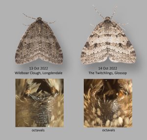
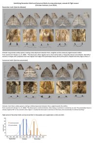


Image Gallery


Temporal Distribution Chart
Adults: (between 1917 - 2025)
Distribution Map for Epirrita autumnata
↳ from 2026+
↳ 39 from 2020 - 2025
↳ 37 from Before 2020
If the Map Layers function fails, just refresh the page and it should be OK after. Use the +- zoom on the top left, or on a tablet, use two fingers to zoom. Remember, the last layer you ticked is the one which displays the popup information - they sit on top of each other - de-select then re-select, to see the popup values.
Bedrock Geology ** indirectly affects moth distribution by influencing the type of habitat and food plants available in an area. In turn, this may affect the types of moths that can thrive, or where they can most likely be found.
NBN Atlas UK Distribution for – Epirrita autumnata
⚠️ Please wait for the map to load fully – do not click the link shown.
Note – the NBN Atlas datasets are listed in the map below and vary in their currency (uptodateness) – however,
the map does give a general indication of the moth's distribution across the UK.
Monthly Records By Year:
Epirrita autumnata
( data includes both Larvae and Adult Stages )
Monthly Counts By Year:
Epirrita autumnata
( data is based on 'Adult' stage records only )
First/Last Recorded Dates: Epirrita autumnata
Adult-only & Anything [Larvae, Pupae, Adult, Mines]
Shading shows moth presence between dates
Click the colour discs below to Select/De-select as Required
Recordings By Year: Epirrita autumnata
( All data includes both Larvae and Adult Stages )
Annual Growth Rate (AGR): Epirrita autumnata
AGR: 2.68% | Total % Change: 93.8%
Hectad (10kmx10km) Coverage: Epirrita autumnata
( data includes both Larvae and Adult Stages )
Flight Periods – Indicative –vs– Recorded Data
Epirrita autumnata
Epirrita autumnata
Flight Period chart – the grey hatched area above, which can cross one or more months, pictorially represents the best guess we have for this moth's flight periods [month/s]. The coloured lines represent the actual months seen in flight, from site observation records received between 2020-2026.
Records Behind the Map and Charts - Epirrita autumnata – 76 records available
Listed by Year - descending - scroll across to see all table columns
| Site Name | Tetrad | Date | Count | Stage | Recorder | Source | RecordKey |
|---|---|---|---|---|---|---|---|
| Longdendale, Wildboar Clough Woodland | SK09U | 05/11/2025 | 12 | Adult | Heintzen, Christian | vc57_irecords_extract | iBRC48826290 |
| Derbyshire Wild Life Trust Long Clough | SK09G | 28/10/2025 | 4 | Adult | Heintzen, Christian | vc57_irecords_extract | iBRC48823689 |
| Longdendale, Wildboar Clough Woodland | SK09U | 20/10/2025 | 6 | Adult | Heintzen, Christian | vc57_irecords_extract | iBRC48823676 |
| Glossop, Gnat Hole Rough Fields | SK09L | 17/10/2025 | 4 | Adult | Heintzen, Christian | vc57_irecords_extract | iBRC48823656 |
| Derbyshire Wild Life Trust Long Clough | SK09G | 13/10/2025 | 2 | Adult | Heintzen, Christian | vc57_irecords_extract | iBRC48823644 |
| Glossop, Gnat Hole Rough Fields | SK09L | 10/10/2025 | 1 | Adult | Heintzen, Christian | vc57_irecords_extract | iBRC48823632 |
| Derbyshire Wild Life Trust Long Clough | SK09G | 06/10/2025 | 1 | Adult | Heintzen, Christian | vc57_irecords_extract | iBRC48823608 |
| Glossop, Hague Street, Hay Meadow | SK09G | 30/09/2025 | 1 | Adult | Heintzen, Christian | vc57_irecords_extract | iBRC48801293 |
| Derbyshire Wild Life Trust Long Clough | SK09G | 30/11/2024 | 1 | Adult | Heintzen, Christian | vc57_irecords_extract | iBRC39768318 |
| Longdendale, Wildboar Clough Woodland | SK09U | 01/11/2024 | 94 | Adult | Heintzen, Christian | vc57_irecords_extract | iBRC39768238 |
| Derbyshire Wild Life Trust Long Clough | SK09G | 31/10/2024 | 33 | Adult | Heintzen, Christian | vc57_irecords_extract | iBRC39768220 |
| Derbyshire Wild Life Trust Long Clough | SK09G | 13/10/2024 | 4 | Adult | Heintzen, Christian | vc57_irecords_extract | iBRC39768194 |
| Derbyshire Wild Life Trust Long Clough | SK09G | 11/10/2024 | 1 | Adult | Heintzen, Christian | vc57_irecords_extract | iBRC39768182 |
| Derbyshire Wild Life Trust Long Clough | SK09G | 23/11/2023 | 1 | Adult | Heintzen, Christian | vc57_irecords_extract | iBRC36337741 |
| Glossop, Shire Hill, south | SK09M | 20/11/2023 | 2 | Adult | Heintzen, Christian | vc57_irecords_extract | iBRC36337723 |
| Derbyshire Wild Life Trust Long Clough | SK09G | 18/11/2023 | 5 | Adult | Heintzen, Christian | vc57_irecords_extract | iBRC36337713 |
| Longdendale, Wildboar Clough | SK09U | 16/11/2023 | 1 | Adult | Heintzen, Christian | vc57_irecords_extract | iBRC36337710 |
| Derbyshire Wild Life Trust Long Clough | SK09G | 14/11/2023 | 6 | Adult | Heintzen, Christian | vc57_irecords_extract | iBRC36337693 |
| Glossop, Gnat Hole Rough Fields | SK09L | 10/11/2023 | 1 | Adult | Heintzen, Christian | vc57_irecords_extract | iBRC36337692 |
| Derbyshire Wild Life Trust Long Clough | SK09G | 08/11/2023 | 27 | Adult | Heintzen, Christian | vc57_irecords_extract | iBRC36337681 |
| Glossop, The Twitchlings | SK09K | 05/11/2023 | 10 | Adult | Heintzen, Christian | vc57_irecords_extract | iBRC36337669 |
| Derbyshire Wild Life Trust Long Clough | SK09G | 03/11/2023 | 69 | Adult | Heintzen, Christian | vc57_irecords_extract | iBRC36337665 |
| Glossop, Gnat Hole Rough Fields | SK09L | 01/11/2023 | 11 | Adult | Heintzen, Christian | vc57_irecords_extract | iBRC36337654 |
| Derbyshire Wild Life Trust Long Clough | SK09G | 29/10/2023 | 1 | Adult | Heintzen, Christian | vc57_irecords_extract | iBRC36337647 |
| Glossop, Shawmoor Plantation | SK09F | 28/10/2023 | 4 | Adult | Heintzen, Christian | vc57_irecords_extract | iBRC36337642 |
| Bolsover | SK47Q | 23/10/2023 | 1 | Adult | Monks, Celia | vc57_irecords_extract | iBRC33586015 |
| Glossop, Gnat Hole Rough Fields | SK09L | 16/10/2023 | 3 | Adult | Heintzen, Christian | vc57_irecords_extract | iBRC36337638 |
| Derbyshire Wild Life Trust Long Clough | SK09G | 15/10/2023 | 2 | Adult | Heintzen, Christian | vc57_irecords_extract | iBRC36337628 |
| Longdendale, Wildboar Clough | SK09U | 07/10/2023 | 2 | Adult | Heintzen, Christian | vc57_irecords_extract | iBRC36337623 |
| Derbyshire Wild Life Trust Long Clough | SK09G | 13/11/2022 | 13 | Adult | Heintzen, Christian | vc57_irecords_extract | iBRC36335550 |
| Glossop, The Twitchlings | SK09K | 08/11/2022 | 1 | Adult | Heintzen, Christian | vc57_irecords_extract | iBRC36335546 |
| Derbyshire Wild Life Trust Long Clough | SK09G | 07/11/2022 | 2 | Adult | Heintzen, Christian | vc57_irecords_extract | iBRC36335539 |
| Glossop, The Twitchlings | SK09K | 05/11/2022 | 1 | Adult | Heintzen, Christian | vc57_irecords_extract | iBRC36335528 |
| Glossop, Shawmoor Plantation | SK09F | 04/11/2022 | 4 | Adult | Heintzen, Christian | vc57_irecords_extract | iBRC36335523 |
| Derbyshire Wild Life Trust Long Clough | SK09G | 03/11/2022 | 1 | Adult | Heintzen, Christian | vc57_irecords_extract | iBRC36335518 |
| Derbyshire Wild Life Trust Long Clough | SK09G | 31/10/2022 | 2 | Adult | Heintzen, Christian | vc57_irecords_extract | iBRC36335509 |
| Derbyshire Wild Life Trust Long Clough | SK09G | 18/10/2022 | 5 | Adult | Heintzen, Christian | vc57_irecords_extract | iBRC36335505 |
| Glossop, The Twitchlings | SK09K | 14/10/2022 | 2 | Adult | Heintzen, Christian | vc57_irecords_extract | iBRC36335481 |
| Longdendale, Wildboar Clough | SK09U | 13/10/2022 | 2 | Adult | Heintzen, Christian | vc57_irecords_extract | iBRC36335475 |
| Not given | SK26R | 11/09/2015 | 1 | Adult | Butler, Andy | vc57_irecords_extract | iBRC2466026 |
| School Close,Parkway Gardens,Darley Dale | SK26R | 14/11/2012 | 1 | Adult | A. Butler | vc57_danes_bc_data | LC000334001OLAHP |
| School Close,Parkway Gardens,Darley Dale | SK26R | 14/11/2012 | 1 | Adult | A. Butler | vc57_danes_bc_data | LC000334001WQHVO |
| Oaks Barn Cottage, Monyash Rd, Over Haddon, Bakewell | SK26D | 04/10/2010 | 1 | Adult | D.A. Clarke | vc57_danes_bc_data | LC000334001OJQUZ |
| Oaks Barn Cottage, Monyash Rd, Over Haddon, Bakewell | SK26D | 03/10/2010 | 1 | Adult | D.A. Clarke | vc57_danes_bc_data | LC000334001OKY71 |
| Oaks Barn Cottage, Monyash Rd, Over Haddon, Bakewell | SK26D | 27/10/2009 | 1 | Adult | D.A. Clarke | vc57_danes_bc_data | LC000334001OKR0A |
| Far Cross,Cavendish Park,Matlock | SK36A | 14/10/2009 | 1 | Adult | B.L. Statham | vc57_danes_bc_data | LC000334001OKQX9 |
| Ashford in the Water | SK16Z | 02/10/2008 | 4 | Adult | D.A. Clarke | vc57_danes_bc_data | LC000334001OKMBS |
| Stainsby,Glapwell | SK46M | 28/10/2006 | 1 | Adult | P. Higginson | vc57_danes_bc_data | LC000334001OHUUV |
| Church St,Holloway,Matlock | SK35I | 15/10/2006 | 1 | Adult | F. Harrison | vc57_danes_bc_data | LC000334001OHUT1 |
| Church St,Holloway,Matlock | SK35I | 08/10/2006 | 1 | Adult | F. Harrison | vc57_danes_bc_data | LC000334001OI97J |
| Cross Green Cottages,Flint Lane,South Darley | SK26Q | 06/10/2004 | 1 | Adult | R. Hawksworth | vc57_danes_bc_data | LC000334001OHR1S |
| School Close,Parkway Gardens,Darley Dale | SK26R | 12/11/2001 | 2 | Adult | A. Butler | vc57_danes_bc_data | LC000334001OJ2J7 |
| The Field,Shipley,Ilkeston | SK44M | 30/09/2000 | 2 | Adult | T. Duro | vc57_danes_bc_data | LC000334001OI3U3 |
| The Field,Shipley,Ilkeston | SK44M | 24/10/1996 | 1 | Adult | T. Duro | vc57_danes_bc_data | LC000334001OHNHV |
| The Field,Shipley,Ilkeston | SK44M | 24/10/1996 | 1 | Adult | T. Duro | vc57_danes_bc_data | LC000334001WPESY |
| Springfield Ave, Sandiacre | SK43S | 08/10/1994 | 1 | Adult | VC57 Derbyshire Recorder | vc57_danes_bc_data | LC000334001OHMMO |
| Woodlands, Combs, Chapel en le Frith | SK07P | 29/10/1993 | 2 | Adult | S.G. Price | vc57_danes_bc_data | LC000334001OIXNT |
| Woodlands, Combs, Chapel en le Frith | SK07P | 19/10/1993 | 3 | Adult | S.G. Price | vc57_danes_bc_data | LC000334001OI1YR |
| Woodlands, Combs, Chapel en le Frith | SK07P | 25/09/1993 | 3 | Adult | S.G. Price | vc57_danes_bc_data | LC000334001OI1Y3 |
| Woodlands, Combs, Chapel en le Frith | SK07P | 26/09/1992 | 1 | Adult | S.G. Price | vc57_danes_bc_data | LC000334001OIWPW |
| Woodlands, Combs, Chapel en le Frith | SK07P | 11/10/1991 | 1 | Adult | S.G. Price | vc57_danes_bc_data | LC000334001OIVS4 |
| Woodlands, Combs, Chapel en le Frith | SK07P | 19/10/1990 | 2 | Adult | S.G. Price | vc57_danes_bc_data | LC000334001OIV1T |
| Beeley Moor, Beeley (site not precies) | SK26Z | 26/08/1990 | 1 | Adult | VC57 Derbyshire Recorder | vc57_danes_bc_data | LC000334001OIUY6 |
| Pond House, Mapperley Res, Ilkeston | SK44G | 07/10/1989 | 1 | Adult | T. Duro | vc57_danes_bc_data | LC000334001OIU3X |
| Pond House, Mapperley Res, Ilkeston | SK44G | 07/10/1989 | 1 | Adult | T. Duro | vc57_danes_bc_data | LC000334001WON8F |
| Pond House, Mapperley Res, Ilkeston | SK44G | 30/09/1989 | 1 | Adult | T. Duro | vc57_danes_bc_data | LC000334001OIU3C |
| Pond House, Mapperley Res, Ilkeston | SK44G | 30/09/1989 | 1 | Adult | T. Duro | vc57_danes_bc_data | LC000334001WON80 |
| Parkway, New Mills | SK08D | 24/09/1986 | 1 | Adult | J. Potts | vc57_danes_bc_data | LC000334001OHJMC |
| Clough Wood,Darley Dale | SK26K | 01/05/1980 | 1 | Adult | D.A. Young | vc57_danes_bc_data | LC000334001OIA2H |
| Moorend, Beeley, Matlock | SK26T | 19/09/1959 | 1 | Adult | VC57 Derbyshire Recorder | vc57_danes_bc_data | LC000334001OIGGC |
| Moorend, Beeley | SK26T | 19/09/1959 | 1 | Adult | B.S. Fletcher | vc57_danes_bc_data | LC000334001WPIR0 |
| Moorend, Beeley, Matlock | SK26T | 01/09/1959 | 1 | Adult | VC57 Derbyshire Recorder | vc57_danes_bc_data | LC000334001OIGFF |
| Moorend, Beeley | SK26T | 01/09/1959 | 1 | Adult | B.S. Fletcher | vc57_danes_bc_data | LC000334001WQ064 |
| Repton area (site not precise) | SK32B | 01/11/1926 | 1 | Adult | VC57 Derbyshire Recorder | vc57_danes_bc_data | LC000334001OHEV8 |
| Repton area (site not precise) | SK32B | 01/11/1926 | 1 | Adult | H.C. Hayward | vc57_danes_bc_data | LC000334001WPZBC |
| Darley Dale (site not precise) | SK26R | 01/10/1917 | 1 | Adult | VC57 Derbyshire Recorder | vc57_danes_bc_data | LC000334001OID84 |