
 – click for General Verification Guidelines | – click for Specific Verification Guidelines
  – Uncertain/Unknown – Insufficient Data
Hay Dale,Derbyshire – Steve Orridge© / Gang Mine (2025) Clive Ashton© / Cromford (2025) Clive Ashton© / Glossop (2025) Christian Heintzen©

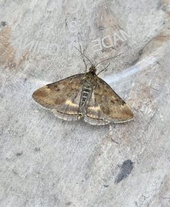
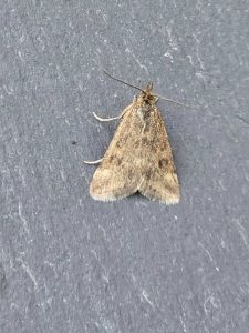


Image Gallery
No gallery images found for this moth.
Temporal Distribution Chart
Adults: (between 1905 - 2025)
Distribution Map for Pyrausta despicata
↳ from 2026+
↳ 59 from 2020 - 2025
↳ 26 from Before 2020
If the Map Layers function fails, just refresh the page and it should be OK after. Use the +- zoom on the top left, or on a tablet, use two fingers to zoom. Remember, the last layer you ticked is the one which displays the popup information - they sit on top of each other - de-select then re-select, to see the popup values.
Bedrock Geology ** indirectly affects moth distribution by influencing the type of habitat and food plants available in an area. In turn, this may affect the types of moths that can thrive, or where they can most likely be found.
NBN Atlas UK Distribution for – Pyrausta despicata
⚠️ Please wait for the map to load fully – do not click the link shown.
Note – the NBN Atlas datasets are listed in the map below and vary in their currency (uptodateness) – however,
the map does give a general indication of the moth's distribution across the UK.
Monthly Records By Year:
Pyrausta despicata
( data includes both Larvae and Adult Stages )
Monthly Counts By Year:
Pyrausta despicata
( data is based on 'Adult' stage records only )
First/Last Recorded Dates: Pyrausta despicata
Adult-only & Anything [Larvae, Pupae, Adult, Mines]
Shading shows moth presence between dates
Click the colour discs below to Select/De-select as Required
Recordings By Year: Pyrausta despicata
( All data includes both Larvae and Adult Stages )
Annual Growth Rate (AGR): Pyrausta despicata
AGR: -2.53% | Total % Change: -41.7%
Hectad (10kmx10km) Coverage: Pyrausta despicata
( data includes both Larvae and Adult Stages )
Flight Periods – Indicative –vs– Recorded Data
Pyrausta despicata
Pyrausta despicata
Flight Period chart – the grey hatched area above, which can cross one or more months, pictorially represents the best guess we have for this moth's flight periods [month/s]. The coloured lines represent the actual months seen in flight, from site observation records received between 2020-2026.
Records Behind the Map and Charts - Pyrausta despicata – 85 records available
Listed by Year - descending - scroll across to see all table columns
| Site Name | Tetrad | Date | Count | Stage | Recorder | Source | RecordKey |
|---|---|---|---|---|---|---|---|
| Glossop, Moorfield, Wood's Cabin | SK09L | 24/08/2025 | 1 | adult | Heintzen, Christian | vc57_irecords_extract | iBRC48746885 |
| Cromford Moor | SK25X | 21/08/2025 | 2 | adult | Ashton, Clive | vc57_irecords_extract | iBRC44789736 |
| Peak Forest | SK17J | 18/08/2025 | 1 | Adult | Josh Hedley | vc57_irecords_extract | iBRC48443987 |
| Bradwell Moor, Derbyshire | SK18F | 18/08/2025 | 1 | adult | Brian Hedley | vc57_irecords_extract | iBRC44564260 |
| Aston-on-Trent, Derbyshire | SK43A | 16/08/2025 | 1 | adult | Waldron, Robert | vc57_irecords_extract | iBRC44503057 |
| Shirland - Hallfieldgate Lane | SK35Z | 15/08/2025 | 1 | adult | Mahadevan, Nikki | vc57_irecords_extract | iBRC44515254 |
| Glossop, Twitchlings | SK09L | 13/08/2025 | 1 | adult | Heintzen, Christian | vc57_irecords_extract | iBRC48740627 |
| Chaddesden Garden | SK33T | 13/08/2025 | 1 | adult | loverock, neil | vc57_irecords_extract | iBRC44493601 |
| Shaw Farm, New Mills VC | SJ98Y | 12/08/2025 | 1 | adult | Hind, Steve | vc57_irecords_extract | iBRC44526571 |
| upper cromford garden | SK25Y | 12/08/2025 | 1 | adult | Ashton, Clive | vc57_irecords_extract | iBRC44517167 |
| Birch Vale | SK08I | 11/08/2025 | 1 | adult | Hewitt, Jane | vc57_irecords_extract | iBRC47544834 |
| Chaddesden Garden | SK33T | 11/08/2025 | 2 | adult | loverock, neil | vc57_irecords_extract | iBRC44381766 |
| Froggatt, Hope Valley | SK27N | 08/08/2025 | 1 | adult | Barnacle, Bryan | vc57_irecords_extract | iBRC44295187 |
| upper cromford garden | SK25Y | 07/08/2025 | 1 | adult | Ashton, Clive | vc57_irecords_extract | iBRC44272054 |
| Ladycroft Ave, Buxton | SK07S | 03/08/2025 | 1 | adult | Orridge, Steve | vc57_irecords_extract | iBRC44146074 |
| Grinlow Woods (east) | SK07K | 17/07/2025 | 1 | adult | Mortin, Jon | vc57_irecords_extract | iBRC43524452 |
| Carsington PS | SK25L | 09/07/2025 | 1 | adult | Ashton, Clive | vc57_irecords_extract | iBRC43235629 |
| Gang Mine, Cromford | SK25X | 09/07/2025 | 10 | adult | Ashton, Clive | vc57_irecords_extract | iBRC43234661 |
| Gang Mine, Cromford | SK25X | 07/07/2025 | 7 | adult | Ashton, Clive | vc57_irecords_extract | iBRC43111466 |
| Hathersage | SK28F | 07/07/2025 | 1 | adult | Kydd, Alan | vc57_irecords_extract | iBRC44145014 |
| High Edge Wildland | SK06U | 05/07/2025 | 1 | adult | Mortin, Jon | vc57_irecords_extract | iBRC43035676 |
| Hollinsclough, Buxton SKRW, UK | SK06U | 05/07/2025 | 1 | Adult | Orridge, Steve | vc57_irecords_extract | iBRC48443851 |
| Chaddesden Garden | SK33T | 03/07/2025 | 1 | adult | loverock, neil | vc57_irecords_extract | iBRC43007668 |
| Slaley, Matlock DEBB, UK | SK25T | 24/06/2025 | 1 | Adult | Nadine | vc57_irecords_extract | iBRC48443850 |
| Chaddesden Garden | SK33T | 24/06/2025 | 1 | adult | loverock, neil | vc57_irecords_extract | iBRC42663859 |
| Grin Low | SK07K | 23/06/2025 | 1 | Adult | Ian M. White | vc57_irecords_extract | iBRC48443846 |
| Gang Mine, Cromford | SK25X | 23/06/2025 | 1 | adult | Ashton, Clive | vc57_irecords_extract | iBRC42573635 |
| Chaddesden Garden | SK33T | 21/06/2025 | 1 | adult | loverock, neil | vc57_irecords_extract | iBRC42660898 |
| High Leas Farm | SK35D | 21/06/2025 | 1 | adult | Thorpe, Steve | vc57_irecords_extract | iBRC48391091 |
| Gang Mine, Cromford | SK25X | 19/06/2025 | 6 | adult | Ashton, Clive | vc57_irecords_extract | iBRC42442451 |
| Gang Mine, Cromford | SK25X | 17/06/2025 | 6 | adult | Ashton, Clive | vc57_irecords_extract | iBRC42378848 |
| Chaddesden Garden | SK33T | 17/06/2025 | 1 | adult | loverock, neil | vc57_irecords_extract | iBRC42714492 |
| Chaddesden Garden | SK33T | 14/06/2025 | 1 | adult | loverock, neil | vc57_irecords_extract | iBRC42715160 |
| Hay Dale | SK17I | 07/05/2025 | 1 | Adult | Ian M. White | vc57_irecords_extract | iBRC41426170 |
| Monks Dale | SK17H | 29/04/2025 | 1 | adult | Marriott, Ant | vc57_irecords_extract | iBRC41429889 |
| Markham Vale Derbyshire | SK47L | 28/04/2025 | 1 | adult | Morris, Sid | vc57_irecords_extract | iBRC41247065 |
| Belper | SK34N | 27/07/2024 | 1 | adult | Evans, Dave | vc57_irecords_extract | iBRC37493925 |
| Longdendale, Woodhead trail | SK19E | 17/05/2024 | 2 | adult | Heintzen, Christian | vc57_irecords_extract | iBRC36371750 |
| Derbyshire, UK | SK17S | 27/04/2024 | 1 | Adult | A Emmerson | vc57_irecords_extract | iBRC35721944 |
| Glossop, Hague Street, Hay meadow | SK09G | 29/07/2023 | 1 | adult | Heintzen, Christian | vc57_irecords_extract | iBRC36336941 |
| Chinley Local Nature Reserve | SK08G | 28/07/2023 | 2 | mine | Hewitt, Jane | vc57_irecords_extract | iBRC34361705 |
| Glossop, Bray Clough | SK09L | 25/07/2023 | 1 | adult | Heintzen, Christian | vc57_irecords_extract | iBRC36336899 |
| Wirksworth Stone Centre | SK25X | 23/07/2023 | 1 | adult | Penson, Melanie | vc57_irecords_extract | iBRC31835602 |
| Ninelands Road | SK28F | 17/07/2023 | 1 | adult | Blues, Clare | vc57_irecords_extract | iBRC31671978 |
| Derbyshire, UK | SK07X | 28/07/2022 | 1 | Adult | Orridge, Steve | vc57_irecords_extract | iBRC29026163 |
| Waterswallows Quarry | SK07X | 28/07/2022 | 1 | adult | Orridge, Steve | vc57_irecords_extract | iBRC35091195 |
| Hoe Grange Quarry, Derbys | SK25I | 03/07/2022 | 1 | adult | Penson, Melanie | vc57_irecords_extract | iBRC26232685 |
| Grinlow Woods, Derbyshire, UK | SK07L | 19/05/2022 | 1 | Adult | Mortin, Jon | vc57_irecords_extract | iBRC25427473 |
| Derbyshire, England, United Kingdom | SK17Q | 14/05/2022 | 1 | Adult | Orridge, Steve | vc57_irecords_extract | iBRC25377287 |
| Grinlow, Derbyshire, UK | SK07K | 20/07/2021 | 1 | Adult | Mortin, Jon | vc57_irecords_extract | iBRC22823003 |
| Shirland - Hallfieldgate Lane | SK35Z | 09/07/2021 | 1 | adult | Mahadevan, Nikki | vc57_irecords_extract | iBRC34957219 |
| Hoe Grange Quarry, Derbyshire | SK25I | 07/07/2021 | 1 | adult | Penson, Melanie | vc57_irecords_extract | iBRC23643494 |
| Derbyshire, England, United Kingdom | SK17I | 02/07/2021 | 1 | Adult | Orridge, Steve | vc57_irecords_extract | iBRC22863132 |
| Hay Dale | SK17I | 02/07/2021 | 1 | adult | Orridge, Steve | vc57_irecords_extract | iBRC39880481 |
| The Mays, Malthouse Lane, Froggatt | SK27N | 24/08/2020 | 1 | adult | BARNACLE, Mr B.&.Mrs.K. | Danes_2019-2021 | 363 |
| Dam Dale | SK17D | 10/08/2020 | 1 | adult | Hewitt, Jane | vc57_irecords_extract | iBRC35067611 |
| Hathersage | SK28F | 17/07/2020 | 1 | adult | Kydd, Alan | vc57_irecords_extract | iBRC39036527 |
| Norton Lees | SK38L | 17/07/2020 | 1 | adult | Mella, Pete | vc57_irecords_extract | iBRC50545943 |
| Ladycroft Ave, Buxton | SK07S | 30/06/2020 | 1 | adult | Orridge, Steve | vc57_irecords_extract | iBRC35095447 |
| Hathersage, Derbyshire, UK | SK28F | 25/07/2019 | 1 | adult | Miles, Claire | vc57_irecords_extract | iBRC12494168 |
| Longstone Edge | SK17W | 06/07/2019 | 1 | adult | Watchorn, Andrew | vc57_irecords_extract | iBRC10811699 |
| Hopton Quarry | SK25T | 20/05/2018 | 1 | Adult | Marriott, Antony | vc57_irecords_extract | iBRC6796400 |
| Bonsall Moor, Bonsall | SK25T | 28/05/2012 | 1 | Adult | A. Butler | vc57_danes_bc_data | LC000334001CP0CX |
| Dovedale | SK15K | 01/08/2011 | 1 | Adult | D. Grundy | vc57_danes_bc_data | LC000334001COU1N |
| Dovedale | SK15K | 11/07/2011 | 2 | Adult | D. Grundy | vc57_danes_bc_data | LC000334001COTY4 |
| Dovedale | SK15K | 11/07/2011 | 1 | Adult | D. Grundy | vc57_danes_bc_data | LC000334001CP77F |
| Lots Lane (nth field), Longcliffe | SK25H | 06/07/2011 | 1 | Adult | K.R. Huston | vc57_danes_bc_data | LC000334001CP75D |
| Dovedale, Lin Dale | SK15K | 15/08/2010 | 1 | adult | Finch, Graham Leonard | vc57_irecords_extract | iBRC35106364 |
| Dovedale (Lin Dale) | SK15K | 15/08/2010 | 1 | Adult | Finch, Graham Leonard | vc57_danes_bc_data | LC000334001COXGH |
| Dovedale | SK15K | 30/07/2010 | 1 | Adult | M.J. Dale | vc57_danes_bc_data | LC000334001COTHW |
| Dovedale (stepping stones) | SK15K | 30/07/2010 | 1 | Adult | D. Grundy | vc57_danes_bc_data | LC000334001COXDL |
| Dovedale | SK15K | 30/07/2010 | 1 | Adult | D. Grundy | vc57_danes_bc_data | LC000334001CP9R3 |
| Dovedale | SK15K | 30/07/2010 | 1 | Adult | D. Grundy | vc57_danes_bc_data | LC000334001CP9RE |
| Dovedale | SK15K | 30/07/2010 | 1 | Adult | D. Grundy | vc57_danes_bc_data | LC000334001CP9RT |
| Biggin Dale, nr Hartington | SK15P | 28/07/2010 | 1 | Adult | D. Grundy | vc57_danes_bc_data | LC000334001COTGV |
| Biggin Dale, nr Hartington | SK15P | 28/07/2010 | 1 | Adult | D. Grundy | vc57_danes_bc_data | LC000334001COTH8 |
| Biggin Dale, nr Hartington | SK15P | 28/07/2010 | 1 | Adult | D. Grundy | vc57_danes_bc_data | LC000334001CP66W |
| Dovedale | SK15K | 25/07/2010 | 1 | Adult | D. Grundy | vc57_danes_bc_data | LC000334001CP62Y |
| Dovedale | SK15K | 25/07/2010 | 1 | Adult | D. Grundy | vc57_danes_bc_data | LC000334001CP645 |
| Bonsall Mines,Cromford | SK25T | 12/07/2009 | 1 | Adult | Roddis, Simon | vc57_danes_bc_data | LC000334001COWTG |
| Long Dale (Mouldridge Grange), Pikehall | SK25E | 28/07/2006 | 1 | Adult | F. Harrison | vc57_danes_bc_data | LC000334001COW41 |
| Bonsall Moor | SK25T | 19/07/2004 | 3 | Adult | B.L. Statham | vc57_danes_bc_data | LC000334001CP20X |
| Ivy Cottage, Youlgreave | SK26C | 28/07/1998 | 1 | Adult | Julian Clarke | vc57_danes_bc_data | LC000334001CP1CQ |
| Ivy Cottage, Youlgreave | SK26C | 26/07/1998 | 1 | Adult | Julian Clarke | vc57_danes_bc_data | LC000334001COQYX |
| Clough Wood,Darley Dale | SK26K | 19/06/1905 | 2 | Adult | B.L. Statham | vc57_danes_bc_data | LC000334001COZII |