
 Leaf-miner: CAT L – The leaf or a Photo required –
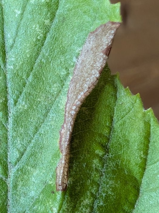
  Larval Case: C1 – Distinctive Species –
  – click for General Verification Guidelines | – click for Specific Verification Guidelines
  – Uncertain/Unknown – Insufficient Data
  – Leaf-miner
Confusion Species: Parornix finitimella (Southern Blackthorn Parornix); Parornix devoniella (Hazel Parornix)
Mine Period Additional: None.
Mine ID Difficulty:
Mine Type/s: Blotch
Mine Feeding Method/s: Leaf Fold
Mine Comment: The larva creates a brown blotch mine on the underside of the host leaf, subsequently living under a silken membrane that folds or puckers the leaf edge. The pupa overwinters in a cocoon, often within a folded leaf on the ground.


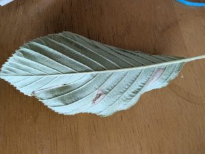

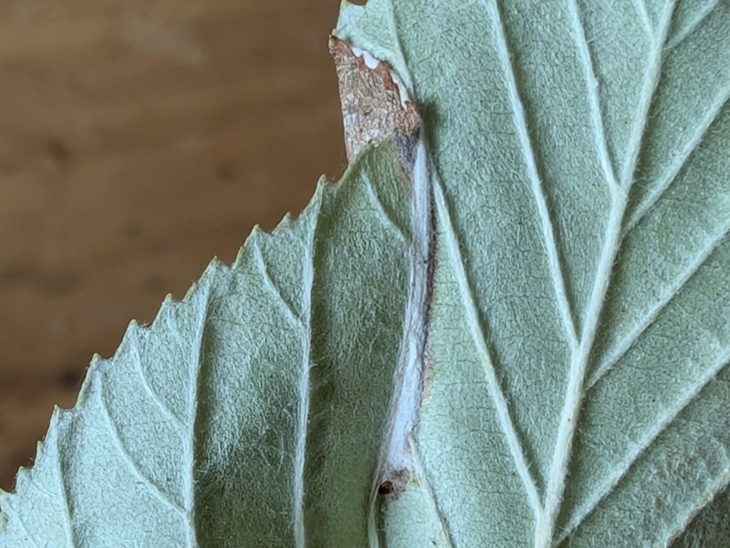


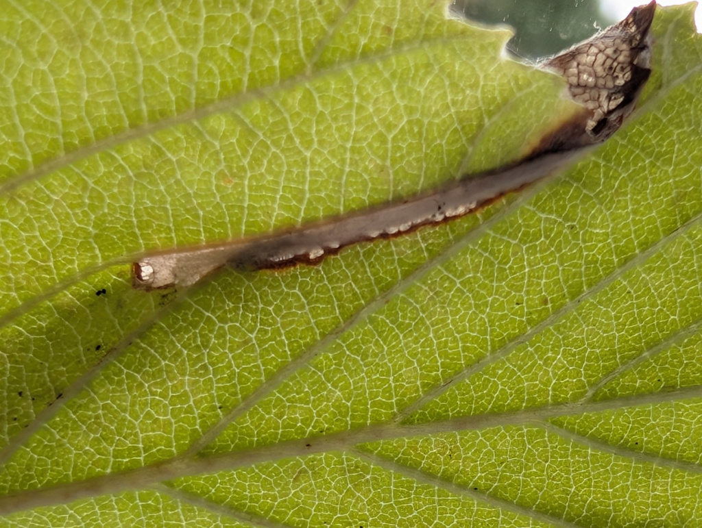
Image Gallery


Temporal Distribution Chart
Adults: (between 1920 - 2000) | Immatures: (between 2010 - 2025)
Distribution Map for Parornix scoticella
↳ from 2026+
↳ 2 from 2020 - 2025
↳ 7 from Before 2020
If the Map Layers function fails, just refresh the page and it should be OK after. Use the +- zoom on the top left, or on a tablet, use two fingers to zoom. Remember, the last layer you ticked is the one which displays the popup information - they sit on top of each other - de-select then re-select, to see the popup values.
Bedrock Geology ** indirectly affects moth distribution by influencing the type of habitat and food plants available in an area. In turn, this may affect the types of moths that can thrive, or where they can most likely be found.
NBN Atlas UK Distribution for – Parornix scoticella
⚠️ Please wait for the map to load fully – do not click the link shown.
Note – the NBN Atlas datasets are listed in the map below and vary in their currency (uptodateness) – however,
the map does give a general indication of the moth's distribution across the UK.
Monthly Records By Year:
Parornix scoticella
( data includes both Larvae and Adult Stages )
Monthly Counts By Year:
Parornix scoticella
( data is based on 'Adult' stage records only )
First/Last Recorded Dates: Parornix scoticella
Adult-only & Anything [Larvae, Pupae, Adult, Mines]
Shading shows moth presence between dates
Click the colour discs below to Select/De-select as Required
Recordings By Year: Parornix scoticella
( All data includes both Larvae and Adult Stages )
Annual Growth Rate (AGR): Parornix scoticella
AGR: 0% | Total % Change: 0%
Hectad (10kmx10km) Coverage: Parornix scoticella
( data includes both Larvae and Adult Stages )
Flight Periods – Indicative –vs– Recorded Data
Parornix scoticella
Parornix scoticella
Flight Period chart – the grey hatched area above, which can cross one or more months, pictorially represents the best guess we have for this moth's flight periods [month/s]. The coloured lines represent the actual months seen in flight, from site observation records received between 2020-2026.
Mine Periods – Indicative –vs– Recorded Data
Parornix scoticella
Parornix scoticella
( data includes both Larvae and Adult Stages )
Mine Period chart – the grey hatched area above, which can cross one or more months, pictorially represents the best guess we have for this moth's mine periods [month/s]. The coloured lines represent the actual months seen mining, from site observation records received between 2020-2026.
Records Behind the Map and Charts - Parornix scoticella – 9 records available
Listed by Year - descending - scroll across to see all table columns
| Site Name | Tetrad | Date | Count | Stage | Recorder | Source | RecordKey |
|---|---|---|---|---|---|---|---|
| Shirland - Hallfieldgate Lane | SK35Z | 30/08/2025 | 1 | mine (empty) | Mahadevan, Nikki | vc57_irecords_extract | iBRC44925933 |
| Hope Woodlands, Snake Road | SK19A | 24/08/2025 | 1 | Larva | Neil Sherman | vc57_irecords_extract | iBRC48244962 |
| Millers Dale | SK17G | 03/09/2011 | 1 | Larval Mine | S.H. Hind | vc57_danes_bc_data | LC000334001CP7LI |
| Bamford | SK28B | 21/09/2010 | 1 | Larval Mine | K. McCabe;S.H. Hind | vc57_danes_bc_data | LC000334001CP6OL |
| Ladybower Resr | SK18U | 03/09/2010 | 1 | Larval Mine | S.H. Hind | vc57_danes_bc_data | LC000334001CP6L0 |
| Upper Wood, Howden Resr | SK19R | 25/08/2010 | 1 | Larval Mine | S.H. Hind | vc57_danes_bc_data | LC000334001CP09L |
| Padley Gorge, Nether Padley | SK27P | 19/08/2010 | 1 | Larval Mine | S.H. Hind | vc57_danes_bc_data | LC000334001CP6HT |
| Mickleover | SK33C | 29/09/2000 | 1 | Adult | VC57 Derbyshire Recorder | vc57_danes_bc_data | LC000334001COQZD |
| Repton Shrubs, Repton (site not precise) | SK32B | 15/05/1920 | 1 | Adult | VC57 Derbyshire Recorder | vc57_danes_bc_data | LC000334001CP9U8 |