
 Leaf-miner:
CAT L
– The leaf or a Photo required –
Leaf-miner:
CAT L
– The leaf or a Photo required –
 Larval Case:
C1
– Distinctive Species –
Larval Case:
C1
– Distinctive Species –
 – click for General Verification Guidelines |
– click for Specific Verification Guidelines
– click for General Verification Guidelines |
– click for Specific Verification Guidelines
 – Uncommon / Scarce
 – Leaf-miner
Mine Period Additional: None.
Mine ID Difficulty:
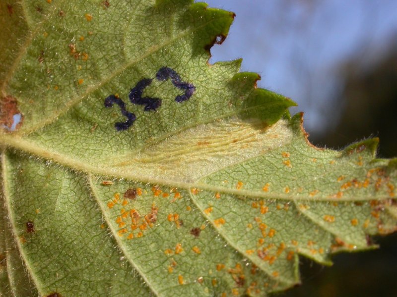
Mine Type/s: Blotch
Mine Feeding Method/s: Not Recorded
Mine Comment: The larvae create a distinctive blotch mine on the underside of a birch leaf, often small but puckers the leaf noticeably. The mine is small (8-14 mm long) and causes the leaf to pucker noticeably, often resulting in several (can be up to 6) creases in the lower epidermis. A small lower surface tentiform mine and all frass is in a corner of the mine.
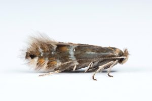
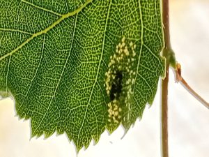


Image Gallery

Temporal Distribution Chart
Adults: (between 2007 - 2025) | Immatures: (between 2001 - 2026)
Distribution Map for Phyllonorycter ulmifoliella
↳ 2 from 2026+
↳ 7 from 2020 - 2025
↳ 20 from Before 2020
If the Map Layers function fails, just refresh the page and it should be OK after. Use the +- zoom on the top left, or on a tablet, use two fingers to zoom. Remember, the last layer you ticked is the one which displays the popup information - they sit on top of each other - de-select then re-select, to see the popup values.
Bedrock Geology ** indirectly affects moth distribution by influencing the type of habitat and food plants available in an area. In turn, this may affect the types of moths that can thrive, or where they can most likely be found.
NBN Atlas UK Distribution for – Phyllonorycter ulmifoliella
⚠️ Please wait for the map to load fully – do not click the link shown.
Note – the NBN Atlas datasets are listed in the map below and vary in their currency (uptodateness) – however,
the map does give a general indication of the moth's distribution across the UK.
Monthly Records By Year:
Phyllonorycter ulmifoliella
( data includes both Larvae and Adult Stages )
Monthly Counts By Year:
Phyllonorycter ulmifoliella
( data is based on 'Adult' stage records only )
First/Last Recorded Dates: Phyllonorycter ulmifoliella
Adult-only & Anything [Larvae, Pupae, Adult, Mines]
Shading shows moth presence between dates
Click the colour discs below to Select/De-select as Required
Recordings By Year: Phyllonorycter ulmifoliella
( All data includes both Larvae and Adult Stages )
Annual Growth Rate (AGR): Phyllonorycter ulmifoliella
AGR: 2.81% | Total % Change: 100%
Hectad (10kmx10km) Coverage: Phyllonorycter ulmifoliella
( data includes both Larvae and Adult Stages )
Flight Periods – Indicative –vs– Recorded Data
Phyllonorycter ulmifoliella
Phyllonorycter ulmifoliella
Flight Period chart – the grey hatched area above, which can cross one or more months, pictorially represents the best guess we have for this moth's flight periods [month/s]. The coloured lines represent the actual months seen in flight, from site observation records received between 2020-2026.
Mine Periods – Indicative –vs– Recorded Data
Phyllonorycter ulmifoliella
Phyllonorycter ulmifoliella
( data includes both Larvae and Adult Stages )
Mine Period chart – the grey hatched area above, which can cross one or more months, pictorially represents the best guess we have for this moth's mine periods [month/s]. The coloured lines represent the actual months seen mining, from site observation records received between 2020-2026.
Records Behind the Map and Charts - Phyllonorycter ulmifoliella – 29 records available
Listed by Year - descending - scroll across to see all table columns
| Site Name | Tetrad | Date | Count | Stage | Recorder | Source | RecordKey |
|---|---|---|---|---|---|---|---|
| Darwin Forest | SK36C | 18/06/2026 | 3 | mine | Evans, Dave | vc57_irecords_extract | iBRC53825295 |
| Markham Vale South Tip | SK47K | 04/06/2026 | 1 | mine | Radford, Mark | vc57_irecords_extract | iBRC53129600 |
| Rowlee Bridge, Woodlands Valley | SK18P | 04/11/2025 | 1 | Leaf-mine | Heintzen, Christian | vc57_irecords_extract | iBRC47521379 |
| Allestree, Derby | SK33P | 03/09/2025 | 1 | Adult | Plant, Stephen | vc57_irecords_extract | iBRC45857000 |
| Hope Woodlands, Snake Road | SK19A | 24/08/2025 | 1 | Larva | Neil Sherman | vc57_irecords_extract | iBRC48244961 |
| Limb Valley, Sheffield | SK38B | 22/05/2025 | 1 | mine (tenant | Watchorn, Andrew | vc57_irecords_extract | iBRC42017943 |
| Derbyshire Wild Life Trust Long Clough | SK09G | 24/04/2025 | 1 | Adult | Heintzen, Christian | vc57_irecords_extract | iBRC43978992 |
| Carver's Rocks | SK32H | 21/09/2023 | 1 | Mine | Finch, Graham Leonard | vc57_irecords_extract | iBRC35106115 |
| Woodland Ave | SK43R | 24/07/2021 | 1 | Adult | Thorpe, Steve | vc57_irecords_extract | iBRC33499093 |
| Derbyshire, UK | SK07M | 16/09/2019 | 1 | Larva | Orridge, Steve | vc57_irecords_extract | iBRC40320518 |
| Blacka Moor and Plantation | SK28Q | 27/07/2016 | 1 | mine (tenant | Watchorn, Andrew | vc57_irecords_extract | iBRC3920067 |
| Millers Dale | SK17G | 03/09/2011 | 1 | Larval Mine | S.H. Hind | vc57_danes_bc_data | LC000334001COU5E |
| Ladybower Resr | SK18U | 03/09/2010 | 1 | Larval Mine | S.H. Hind | vc57_danes_bc_data | LC000334001CP6LB |
| Howden Resr | SK19L | 25/08/2010 | 1 | Larval Mine | S.H. Hind | vc57_danes_bc_data | LC000334001CP096 |
| Slippery Stones,Upper Derwent | SK19S | 25/08/2010 | 1 | Larval Mine | S.H. Hind | vc57_danes_bc_data | LC000334001COXIG |
| Padley Gorge, Nether Padley | SK27P | 19/08/2010 | 1 | Larval Mine | S.H. Hind | vc57_danes_bc_data | LC000334001CP6I1 |
| Hopton Wood NR, Cromford | SK25T | 16/10/2009 | 1 | Larval Mine | Dave Budworth;S.A. Orridge;S.H. Hind | vc57_danes_bc_data | LC000334001COT0Z |
| Rose End Meadow | SK25Y | 16/10/2009 | 1 | mine | Orridge, Steve; Hind, Steve, Budworth, Dave | vc57_irecords_extract | iBRC40312707 |
| Linacre | SK37L | 13/10/2009 | 1 | Larval Mine | S.H. Hind | vc57_danes_bc_data | LC000334001CP55G |
| Norbury | SK14G | 01/10/2009 | 1 | Larval Mine | Dave Budworth;S.A. Orridge;S.H. Hind | vc57_danes_bc_data | LC000334001COWY5 |
| Monsall Trail, Buxton | SK17L | 14/09/2008 | 1 | Larval Mine | S.H. Hind | vc57_danes_bc_data | LC000334001COSNT |
| Robin Wood, Ticknall | SK32M | 01/05/2007 | 1 | Adult | Dave Budworth | vc57_danes_bc_data | LC000334001CP3RF |
| Foremark Reservoir | SK32H | 13/04/2007 | 2 | Adult | Davison, Tony | vc57_irecords_extract | iBRC33398723 |
| Foremark Reservoir, Derbyshire | SK32H | 13/04/2007 | 2 | Adult | Davison, Tony | vc57_irecords_extract | iBRC33398767 |
| Foremark Resr, Ticknall | SK32H | 13/04/2007 | 2 | Adult | BUDWORTH, Mr D., DAVISON, Mr A., PEACH, Mr K., TOP | vc57_danes_bc_data | LC000334001COS35 |
| Ogston Carr Wood,nr Ogston Res | SK35U | 12/07/2006 | 1 | Larval Mine | S.H. Hind | vc57_danes_bc_data | LC000334001CORSM |
| Clattercotes Wood, nr Ogston Resr | SK36Q | 12/07/2006 | 1 | Larval Mine | S.H. Hind | vc57_danes_bc_data | LC000334001CORSZ |
| Brackley Gate, nr Coxbench | SK34W | 03/11/2001 | 1 | Larval Mine | S.H. Hind | vc57_danes_bc_data | LC000334001COR0G |
| Cubley, nr Ashbourne | SK13U | 04/10/2001 | 1 | Larval Mine | S.H. Hind | vc57_danes_bc_data | LC000334001CP1F6 |