 – click for Adult Macro Verification Guidelines
 – Uncommon / Scarce
Forewing: 15-17mm


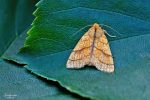
Image Gallery

Temporal Distribution Chart
Adults: (between 1962 - 2025) | Immatures: (between 1975 - 1975)
Distribution Map for Tiliacea citrago
↳ from 2026+
↳ 41 from 2020 - 2025
↳ 73 from Before 2020
If the Map Layers function fails, just refresh the page and it should be OK after. Use the +- zoom on the top left, or on a tablet, use two fingers to zoom. Remember, the last layer you ticked is the one which displays the popup information - they sit on top of each other - de-select then re-select, to see the popup values.
Bedrock Geology ** indirectly affects moth distribution by influencing the type of habitat and food plants available in an area. In turn, this may affect the types of moths that can thrive, or where they can most likely be found.
NBN Atlas UK Distribution for – Tiliacea citrago
⚠️ Please wait for the map to load fully – do not click the link shown.
Note – the NBN Atlas datasets are listed in the map below and vary in their currency (uptodateness) – however,
the map does give a general indication of the moth's distribution across the UK.
Monthly Records By Year:
Tiliacea citrago
( data includes both Larvae and Adult Stages )
Monthly Counts By Year:
Tiliacea citrago
( data is based on 'Adult' stage records only )
First/Last Recorded Dates: Tiliacea citrago
Adult-only & Anything [Larvae, Pupae, Adult, Mines]
Shading shows moth presence between dates
Click the colour discs below to Select/De-select as Required
Recordings By Year: Tiliacea citrago
( All data includes both Larvae and Adult Stages )
Annual Growth Rate (AGR): Tiliacea citrago
AGR: 0.21% | Total % Change: 5.3%
Hectad (10kmx10km) Coverage: Tiliacea citrago
( data includes both Larvae and Adult Stages )
Flight Periods – Indicative –vs– Recorded Data
Tiliacea citrago
Tiliacea citrago
Flight Period chart – the grey hatched area above, which can cross one or more months, pictorially represents the best guess we have for this moth's flight periods [month/s]. The coloured lines represent the actual months seen in flight, from site observation records received between 2020-2026.
Records Behind the Map and Charts - Tiliacea citrago – 114 records available
Listed by Year - descending - scroll across to see all table columns
| Site Name | Tetrad | Date | Count | Stage | Recorder | Source | RecordKey |
|---|---|---|---|---|---|---|---|
| Belper, Derbyshire | SK34N | 16/10/2025 | 1 | Adult | Newcombe, Dave | vc57_irecords_extract | iBRC50611110 |
| Dronfield, Derbyshire | SK37T | 30/09/2025 | 1 | Adult | Stoppard, Peter | vc57_irecords_extract | iBRC45734419 |
| sheffield | SK38M | 27/09/2025 | 1 | Adult | Turner, Jan | vc57_irecords_extract | iBRC45731108 |
| sheffield | SK38M | 25/09/2025 | 1 | Adult | Turner, Jan | vc57_irecords_extract | iBRC45730590 |
| Norton Lees, Sheffield | SK38L | 19/09/2025 | 1 | Adult | Mella, Pete | vc57_irecords_extract | iBRC45455429 |
| sheffield | SK38M | 19/09/2025 | 1 | Adult | Turner, Jan | vc57_irecords_extract | iBRC45494467 |
| sheffield | SK38M | 17/09/2025 | 1 | Adult | Turner, Jan | vc57_irecords_extract | iBRC45494101 |
| sheffield | SK38M | 12/09/2025 | 1 | Adult | Turner, Jan | vc57_irecords_extract | iBRC45357583 |
| Ladycroft Ave, Buxton | SK07S | 02/09/2025 | 2 | Adult | Orridge, Steve | vc57_irecords_extract | iBRC48199768 |
| Oakwood, Derby, Derby | SK33Y | 02/09/2025 | 1 | Adult | Charles, Nick | vc57_irecords_extract | iBRC45018307 |
| Norton Lees, Sheffield | SK38L | 31/08/2025 | 1 | Adult | Mella, Pete | vc57_irecords_extract | iBRC44987374 |
| Chaddesden, Derby | SK33T | 25/08/2025 | 1 | Adult | Roome, Martin | vc57_irecords_extract | iBRC44886477 |
| Glapwell Garden Trap | SK46T | 23/08/2025 | 1 | Adult | Culpin, John | vc57_irecords_extract | iBRC50332521 |
| sheffield | SK38M | 17/08/2025 | 1 | Adult | Turner, Jan | vc57_irecords_extract | iBRC44703698 |
| sheffield | SK38M | 16/08/2025 | 1 | Adult | Turner, Jan | vc57_irecords_extract | iBRC44683692 |
| Chaddesden, Derby | SK33T | 14/08/2025 | 1 | Adult | Roome, Martin | vc57_irecords_extract | iBRC44572110 |
| sheffield | SK38M | 13/08/2025 | 1 | Adult | Turner, Jan | vc57_irecords_extract | iBRC44540249 |
| Ladycroft Ave, Buxton | SK07S | 12/08/2025 | 1 | Adult | Orridge, Steve | vc57_irecords_extract | iBRC48187043 |
| Chaddesden Garden | SK33T | 11/08/2025 | 1 | Adult | Loverock, Neil | vc57_irecords_extract | iBRC44381773 |
| upper cromford garden | SK25Y | 29/10/2024 | 1 | Adult | Ashton, Clive | vc57_irecords_extract | iBRC39032594 |
| Sandiacre Garden | SK43T | 09/09/2024 | 1 | Adult | Milnes, Emily | vc57_irecords_extract | iBRC41567224 |
| upper cromford garden | SK25Y | 07/09/2024 | 1 | Adult | Ashton, Clive | vc57_irecords_extract | iBRC38378639 |
| Upper Cromford Garden | SK25Y | 22/09/2023 | 1 | Adult | Ashton, Clive | vc57_irecords_extract | iBRC34568650 |
| Buxton SK, UK | SK07S | 16/09/2023 | 1 | Adult | Orridge, Steve | vc57_irecords_extract | iBRC33773608 |
| Buxton SK, UK | SK07R | 09/09/2023 | 1 | Adult | White, Ian M | vc57_irecords_extract | iBRC32918826 |
| Ladycroft Ave | SK07S | 08/09/2023 | 1 | Adult | Orridge, Steve | vc57_irecords_extract | iBRC35076064 |
| Mellor | SJ98Z | 07/09/2023 | 1 | Adult | Knass, David | vc57_irecords_extract | iBRC32888936 |
| Morley Retreat | SK34V | 06/09/2023 | 2 | Adult | Thorpe, Steve | vc57_irecords_extract | iBRC33497270 |
| Lower Cromford Garden | SK25Y | 19/09/2022 | 1 | Adult | Ashton, Clive | vc57_irecords_extract | iBRC34569395 |
| Main Street, Kings Newton | SK32Y | 14/09/2022 | 1 | Adult | Soar, Will | vc57_irecords_extract | iBRC34062440 |
| Lower Cromford Garden | SK25Y | 12/09/2022 | 1 | Adult | Ashton, Clive | vc57_irecords_extract | iBRC34569370 |
| Woodland Ave | SK43R | 26/08/2022 | 1 | Adult | Thorpe, Steve | vc57_irecords_extract | iBRC33495235 |
| Middleton by Wirksworth | SK25T | 26/09/2021 | 1 | Adult | Dinsdale, Kay | vc57_irecords_extract | iBRC30096277 |
| Birch Vale | SK08I | 16/09/2021 | 1 | Adult | Hewitt, Jane | vc57_irecords_extract | iBRC34473028 |
| Main Street, Kings Newton | SK32Y | 06/09/2021 | 1 | Adult | Soar, Will | vc57_irecords_extract | iBRC34062439 |
| Middleton by Youlgreave | SK16W | 30/08/2021 | 1 | Adult | Aston, Doug | vc57_irecords_extract | iBRC39283519 |
| Ninelands Road | SK28F | 09/10/2020 | 1 | Adult | Blues, Clare | vc57_irecords_extract | iBRC27429452 |
| Woodland Ave | SK43R | 20/09/2020 | 1 | Adult | Thorpe, Steve | vc57_irecords_extract | iBRC33502330 |
| Findern, Derbyshire, DEAZ | SK33A | 14/09/2020 | 1 | Adult | Hallam, Brian and Jean | vc57_irecords_extract | iBRC35164181 |
| Allestree, Derby | SK33P | 13/09/2020 | 1 | Adult | Plant, Stephen | vc57_irecords_extract | iBRC46326359 |
| Allestree, Derby | SK33P | 13/09/2020 | 1 | Adult | Plant, Stephen | vc57_irecords_extract | iBRC46557972 |
| Not given | SK36C | 26/09/2019 | 1 | Adult | Evans, Dave | vc57_irecords_extract | iBRC11864464 |
| Hathersage, Derbyshire, UK | SK28F | 22/09/2019 | 1 | Adult | Miles, Claire | vc57_irecords_extract | iBRC12279258 |
| Ladycroft Ave, Buxton | SK07S | 06/09/2019 | 2 | adult | ORRIDGE, Mr S.A. | Danes_2019-2021 | 940 |
| Belper | SK34N | 06/09/2019 | 1 | Adult | Evans, Dave | vc57_irecords_extract | iBRC35298452 |
| Marlborough Road, Long Eaton | SK43X | 17/09/2018 | 1 | Adult | Bryce, Marion | vc57_irecords_extract | iBRC7955752 |
| Main Street, Kings Newton | SK32Y | 25/09/2017 | 1 | Adult | Soar, Will | vc57_irecords_extract | iBRC34062441 |
| Back Lane, Glapwell | SK46T | 17/09/2015 | 1 | Adult | J. Culpin | vc57_danes_bc_data | LC000334001WOV1Y |
| Midway Rd,Midway,Swadlincote | SK32A | 05/09/2014 | 1 | Adult | M.J. Williams | vc57_danes_bc_data | LC000334001WQJ2M |
| School Close,Parkway Gardens,Darley Dale | SK26R | 02/10/2011 | 1 | Adult | A. Butler | vc57_danes_bc_data | LC000334001OL4YB |
| High Tor,Matlock Bath | SK25Z | 29/09/2011 | 5 | Adult | A. Butler;B.L. Statham | vc57_danes_bc_data | LC000334001OJTS9 |
| Backgarden Marehay | SK34Z | 28/09/2011 | 1 | Adult | Thorpe, Steve | vc57_irecords_extract | iBRC33514189 |
| Bamford St,Ripley | SK34Z | 28/09/2011 | 1 | Adult | Thorpe, Steve | vc57_danes_bc_data | LC000334001OK84Z |
| National Stone Centre,Wirksworth | SK25X | 24/09/2011 | 1 | Adult | A. Butler;B.L. Statham | vc57_danes_bc_data | LC000334001OL4OK |
| Buxton SK, UK | SK07S | 17/09/2011 | 1 | Adult | Orridge, Steve | vc57_irecords_extract | iBRC22503713 |
| Ladycroft Ave,Buxton | SK07S | 16/09/2011 | 2 | Adult | Orridge, Steve | vc57_danes_bc_data | LC000334001OL4HZ |
| Ladycroft Ave, Buxton | SK07S | 16/09/2011 | 2 | Adult | Orridge, Steve | vc57_danes_bc_data | LC000334001WPBVO |
| School Close,Parkway Gardens,Darley Dale | SK26R | 14/09/2011 | 1 | Adult | A. Butler | vc57_danes_bc_data | LC000334001OL4GK |
| School Close,Parkway Gardens,Darley Dale | SK26R | 13/09/2011 | 1 | Adult | A. Butler | vc57_danes_bc_data | LC000334001OK80Y |
| School Close,Parkway Gardens,Darley Dale | SK26R | 06/09/2011 | 1 | Adult | A. Butler | vc57_danes_bc_data | LC000334001OL4BZ |
| Hardhurst Rd, Alvaston, Derby | SK33W | 31/08/2011 | 1 | Adult | I. Gardler | vc57_danes_bc_data | LC000334001WPBSK |
| Hardhurst Rd, Alvaston, Derby | SK33W | 25/08/2011 | 1 | Adult | I. Gardler | vc57_danes_bc_data | LC000334001WQH86 |
| Ault Hucknall,Glapwell | SK46S | 10/10/2010 | 1 | Adult | M.E. Bradley | vc57_danes_bc_data | LC000334001OKYC0 |
| School Close,Parkway Gardens,Darley Dale | SK26R | 30/09/2010 | 1 | Adult | A. Butler | vc57_danes_bc_data | LC000334001OJQUE |
| Rose Av,Clowne | SK57D | 09/09/2010 | 1 | Adult | D. Hursthouse | vc57_danes_bc_data | LC000334001OK54L |
| School Close,Parkway Gardens,Darley Dale | SK26R | 05/09/2010 | 1 | Adult | A. Butler | vc57_danes_bc_data | LC000334001OKXOK |
| Drayton Ave,Mackworth,Derby | SK33D | 20/09/2009 | 1 | Adult | W. Hurst | vc57_danes_bc_data | LC000334001OK308 |
| Drayton Ave,Mackworth,Derby | SK33D | 20/09/2009 | 1 | Adult | W. Hurst | vc57_danes_bc_data | LC000334001WQ2AW |
| Duffield Rd, Allestree, Derby | SK34K | 28/09/2008 | 1 | Adult | P. Smith | vc57_danes_bc_data | LC000334001OKMBN |
| Duffield Rd, Allestree, Derby | SK34K | 28/09/2008 | 1 | Adult | P. Smith | vc57_danes_bc_data | LC000334001WQ6QT |
| The Hollies,Station Rd,Darley Dale | SK26R | 16/09/2008 | 1 | Adult | Roddis, Simon | vc57_danes_bc_data | LC000334001OKM6G |
| Glebe Rise,Littleover,Derby | SK33H | 29/08/2008 | 1 | Adult | N.J. Ward | vc57_danes_bc_data | LC000334001OK0PG |
| The Hollies,Station Rd,Darley Dale | SK26R | 11/09/2007 | 1 | Adult | Roddis, Simon | vc57_danes_bc_data | LC000334001OKIXC |
| Melbourne, Derbyshire | SK32X | 01/09/2007 | 1 | Adult | Davison, Tony | vc57_irecords_extract | iBRC33410001 |
| Church St,Holloway,Matlock | SK35I | 24/09/2006 | 1 | Adult | F. Harrison | vc57_danes_bc_data | LC000334001OJGHT |
| Robin's Cross (Woodland Trust site) | SK32C | 15/09/2006 | 1 | Adult | Soar, Will | vc57_irecords_extract | iBRC34680338 |
| Robin's Cross (Woodland Trust site), Repton | SK32C | 15/09/2006 | 1 | Adult | BUDWORTH, Mr D., WILLIAMS, Mr M.J., WILLIAMS, Mrs | vc57_danes_bc_data | LC000334001OHUKG |
| Robin's Cross (Woodland Trust site), Repton | SK32C | 15/09/2006 | 1 | Adult | Dave Budworth;M.J. Williams;R. Williams;W. Soar | vc57_danes_bc_data | LC000334001WP6WA |
| School Close,Parkway Gardens,Darley Dale | SK26R | 26/08/2006 | 1 | Adult | A. Butler | vc57_danes_bc_data | LC000334001OI8RT |
| The Hollies,Station Rd,Darley Dale | SK26R | 25/08/2006 | 1 | Adult | Roddis, Simon | vc57_danes_bc_data | LC000334001OHUAC |
| Far Cross,Cavendish Park,Matlock | SK36A | 17/08/2006 | 2 | Adult | B.L. Statham | vc57_danes_bc_data | LC000334001OHU7R |
| Church St,Holloway,Matlock | SK35I | 07/10/2005 | 1 | Adult | F. Harrison | vc57_danes_bc_data | LC000334001OHSCO |
| The Field,Shipley,Ilkeston | SK44M | 07/09/2005 | 1 | Adult | T. Duro | vc57_danes_bc_data | LC000334001OJB0E |
| The Field,Shipley,Ilkeston | SK44M | 07/09/2005 | 1 | Adult | T. Duro | vc57_danes_bc_data | LC000334001WPVEU |
| Church St,Holloway,Matlock | SK35I | 06/09/2004 | 1 | Adult | F. Harrison | vc57_danes_bc_data | LC000334001OJ83N |
| The Field,Shipley,Ilkeston | SK44M | 14/09/2003 | 1 | Adult | T. Duro | vc57_danes_bc_data | LC000334001OJ4NN |
| The Field,Shipley,Ilkeston | SK44M | 14/09/2003 | 1 | Adult | T. Duro | vc57_danes_bc_data | LC000334001WQ1PH |
| Melbourne, Derbyshire | SK32X | 12/09/2003 | 1 | Adult | Davison, Tony | vc57_irecords_extract | iBRC33100028 |
| Ladycroft Ave,Buxton | SK07S | 11/09/2002 | 1 | Adult | Orridge, Steve | vc57_danes_bc_data | LC000334001OHORU |
| Ladycroft Ave, Buxton | SK07S | 11/09/2002 | 1 | Adult | Orridge, Steve | vc57_danes_bc_data | LC000334001WOVEK |
| School Close,Parkway Gardens,Darley Dale | SK26R | 29/08/2002 | 1 | Adult | A. Butler | vc57_danes_bc_data | LC000334001OHORF |
| St Charles Close, Hadfield | SK09D | 19/09/2001 | 1 | Adult | VC57 Derbyshire Recorder | vc57_danes_bc_data | LC000334001OI41G |
| St Charles Close, Hadfield | SK09D | 19/09/2001 | 1 | Adult | P. Greenall | vc57_danes_bc_data | LC000334001WPH2N |
| Lancaster Ave,Sandiacre | SK43S | 14/09/2001 | 1 | Adult | I.M. Viles | vc57_danes_bc_data | LC000334001OI41D |
| Lancaster Ave,Sandiacre | SK43S | 14/09/2001 | 1 | Adult | I.M. Viles | vc57_danes_bc_data | LC000334001WPH2L |
| School Close,Parkway Gardens,Darley Dale | SK26R | 30/09/2000 | 1 | Adult | A. Butler | vc57_danes_bc_data | LC000334001OI3TX |
| School Close,Parkway Gardens,Darley Dale | SK26R | 30/09/2000 | 1 | Adult | A. Butler | vc57_danes_bc_data | LC000334001WPH0N |
| School Close,Parkway Gardens,Darley Dale | SK26R | 03/09/1999 | 1 | Adult | A. Butler;B.L. Statham | vc57_danes_bc_data | LC000334001OJ1NF |
| Far Cross,Cavendish Park,Matlock | SK36A | 06/09/1996 | 2 | Adult | B.L. Statham | vc57_danes_bc_data | LC000334001OI2U8 |
| Shipley Hill, Shipley Park, Ilkeston | SK44H | 03/09/1996 | 1 | Adult | VC57 Derbyshire Recorder | vc57_danes_bc_data | LC000334001OJ0AP |
| Shipley Hill, Shipley Park, Ilkeston | SK44H | 03/09/1996 | 1 | Adult | I. Travers-Ayre;I.M. Viles;T. Duro | vc57_danes_bc_data | LC000334001WPER8 |
| Lang Rd, Alvaston, Derby | SK33R | 01/09/1993 | 1 | Adult | VC57 Derbyshire Recorder | vc57_danes_bc_data | LC000334001OIXML |
| Lang Rd, Alvaston, Derby | SK33R | 01/09/1993 | 1 | Adult | I. Travers-Ayre | vc57_danes_bc_data | LC000334001WPEMU |
| Dorothy Ave, Sandiacre | SK43T | 29/09/1992 | 1 | Adult | I.M. Viles | vc57_danes_bc_data | LC000334001OIWQ9 |
| Deerlands Rd, Ashgate, Chesterfield | SK37K | 12/09/1990 | 1 | Adult | VC57 Derbyshire Recorder | vc57_danes_bc_data | LC000334001OIV05 |
| Wilmot St, Sawley, Long Eaton | SK43R | 24/08/1981 | 1 | Adult | A. Braddock | vc57_danes_bc_data | LC000334001OIO6L |
| Tupton Hall School, Old Tupton, Clay Cross | SK36X | 03/10/1980 | 1 | Adult | J. Culpin | vc57_danes_bc_data | LC000334001OINBV |
| Wilmot St, Sawley, Long Eaton | SK43R | 25/09/1979 | 1 | Adult | A. Braddock | vc57_danes_bc_data | LC000334001OHGOI |
| Stancliffe Hall, Darley Dale | SK26S | 21/05/1975 | 9 | Larvae | VC57 Derbyshire Recorder | vc57_danes_bc_data | LC000334001OHFDY |
| Stancliffe Hall, Darley Dale | SK26S | 20/05/1975 | 9 | Larvae | VC57 Derbyshire Recorder | vc57_danes_bc_data | LC000334001OHFDU |
| Stancliffe Hall, Darley Dale | SK26S | 18/05/1975 | 3 | Larvae | VC57 Derbyshire Recorder | vc57_danes_bc_data | LC000334001OHFDS |
| Newbold Ave, Chesterfield | SK37R | 18/09/1963 | 1 | Adult | VC57 Derbyshire Recorder | vc57_danes_bc_data | LC000334001OHVW3 |
| Chatsworth Park (site not precise) | SK27Q | 26/08/1962 | 1 | Adult | F. Harrison | vc57_danes_bc_data | LC000334001OIH05 |
| Little Eaton, Derby (site not precise) | SK34Q | 01/01/1900 | 1 | Adult | Unknown | vc57_danes_bc_data | LC000334001OJHET |