
 – click for General Verification Guidelines | – click for Specific Verification Guidelines
  – Rare / Uncommon / Scarce


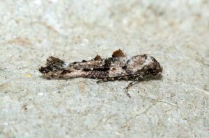
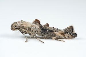
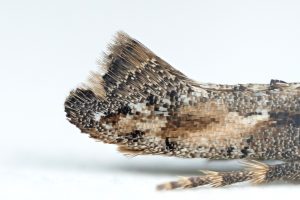
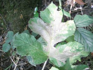
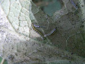


Image Gallery

Temporal Distribution Chart
Adults: (between 2004 - 2025) | Immatures: (between 1998 - 2024)
Distribution Map for Epermenia chaerophyllella
↳ from 2026+
↳ 15 from 2020 - 2025
↳ 22 from Before 2020
If the Map Layers function fails, just refresh the page and it should be OK after. Use the +- zoom on the top left, or on a tablet, use two fingers to zoom. Remember, the last layer you ticked is the one which displays the popup information - they sit on top of each other - de-select then re-select, to see the popup values.
Bedrock Geology ** indirectly affects moth distribution by influencing the type of habitat and food plants available in an area. In turn, this may affect the types of moths that can thrive, or where they can most likely be found.
NBN Atlas UK Distribution for – Epermenia chaerophyllella
⚠️ Please wait for the map to load fully – do not click the link shown.
Note – the NBN Atlas datasets are listed in the map below and vary in their currency (uptodateness) – however,
the map does give a general indication of the moth's distribution across the UK.
Monthly Records By Year:
Epermenia chaerophyllella
( data includes both Larvae and Adult Stages )
Monthly Counts By Year:
Epermenia chaerophyllella
( data is based on 'Adult' stage records only )
First/Last Recorded Dates: Epermenia chaerophyllella
Adult-only & Anything [Larvae, Pupae, Adult, Mines]
Shading shows moth presence between dates
Click the colour discs below to Select/De-select as Required
Recordings By Year: Epermenia chaerophyllella
( All data includes both Larvae and Adult Stages )
Annual Growth Rate (AGR): Epermenia chaerophyllella
AGR: 0% | Total % Change: 0%
Hectad (10kmx10km) Coverage: Epermenia chaerophyllella
( data includes both Larvae and Adult Stages )
Flight Periods – Indicative –vs– Recorded Data
Epermenia chaerophyllella
Epermenia chaerophyllella
Flight Period chart – the grey hatched area above, which can cross one or more months, pictorially represents the best guess we have for this moth's flight periods [month/s]. The coloured lines represent the actual months seen in flight, from site observation records received between 2020-2026.
Records Behind the Map and Charts - Epermenia chaerophyllella – 37 records available
Listed by Year - descending - scroll across to see all table columns
| Site Name | Tetrad | Date | Count | Stage | Recorder | Source | RecordKey |
|---|---|---|---|---|---|---|---|
| Hallowes Lane, Dronfield, England, GB | SK37P | 21/10/2025 | 1 | Adult | La | vc57_irecords_extract | iBRC46041397 |
| Glossop, Hague Street | SK09G | 07/10/2025 | 1 | Adult | Heintzen, Christian | vc57_irecords_extract | iBRC48823620 |
| upper cromford garden | SK25Y | 11/07/2025 | 1 | Adult | Ashton, Clive | vc57_irecords_extract | iBRC43358978 |
| upper cromford garden | SK25Y | 08/07/2025 | 1 | Adult | Ashton, Clive | vc57_irecords_extract | iBRC43234634 |
| Chaddesden Garden | SK33T | 21/06/2025 | 1 | Adult | Loverock, Neil | vc57_irecords_extract | iBRC42660897 |
| rose end meadows | SK25Y | 25/04/2025 | 1 | Adult | Ashton, Clive | vc57_irecords_extract | iBRC41140476 |
| Allestree, Derby | SK33P | 12/04/2025 | 1 | Adult | Plant, Stephen | vc57_irecords_extract | iBRC40948713 |
| Ilkeston, Derbyshire | SK44K | 12/04/2025 | 1 | Adult | Hobby, Brian | vc57_irecords_extract | iBRC41010899 |
| Shirland - Hallfieldgate Lane | SK35Z | 08/04/2025 | 1 | Adult | Mahadevan, Nikki | vc57_irecords_extract | iBRC40784008 |
| King's Newton | SK32Y | 31/03/2025 | 1 | Adult | Soar, Will | vc57_irecords_extract | iBRC40683819 |
| Staveley SYA Garden | SK47H | 21/03/2025 | 1 | Adult | Radford, Mark | vc57_irecords_extract | iBRC40482942 |
| Lower Gamesley VC | SK09C | 31/08/2024 | 10 | larva | Hind, Steve | vc57_irecords_extract | iBRC38243513 |
| upper cromford garden | SK25Y | 31/07/2024 | 1 | Adult | Ashton, Clive | vc57_irecords_extract | iBRC37588803 |
| Belper | SK34U | 16/05/2021 | 1 | Adult | Evans, Dave | vc57_irecords_extract | iBRC35322896 |
| Woodland Ave | SK43R | 29/03/2021 | 1 | Adult | Thorpe, Steve | vc57_irecords_extract | iBRC33498055 |
| Backgarden Marehay | SK34Z | 29/03/2017 | 1 | Adult | Thorpe, Steve | vc57_irecords_extract | iBRC33503557 |
| Backgarden Marehay | SK34Z | 25/03/2017 | 1 | Adult | Thorpe, Steve | vc57_irecords_extract | iBRC33503548 |
| Backgarden Marehay | SK34Z | 15/07/2014 | 1 | Adult | Thorpe, Steve | vc57_irecords_extract | iBRC33507047 |
| Millennium Meadow NR, Duffield | SK34L | 03/05/2014 | 1 | Adult | VC57 Derbyshire Recorder | vc57_danes_bc_data | LC000334001COYVC |
| Hartshorne Wood, Hartshorne, Swadlincote | SK32G | 30/09/2013 | 1 | Adult | Dave Budworth | vc57_danes_bc_data | LC000334001COV0L |
| Millers Dale | SK17G | 03/09/2011 | 1 | Larvae | S.H. Hind | vc57_danes_bc_data | LC000334001CP7LE |
| Bamford | SK28B | 21/09/2010 | 1 | Larval Feeding Signs | K. McCabe;S.H. Hind | vc57_danes_bc_data | LC000334001CP6OD |
| Lathkill Dale | SK26D | 04/09/2010 | 1 | Larval Feeding Signs | S.H. Hind | vc57_danes_bc_data | LC000334001CP6LV |
| Hardhurst Rd, Alvaston, Derby | SK33W | 06/04/2010 | 2 | Adult | I. Gardler | vc57_danes_bc_data | LC000334001CP574 |
| Tissington Trail, Ashbourne | SK14T | 01/10/2009 | 1 | Case | Dave Budworth;S.A. Orridge;S.H. Hind | vc57_danes_bc_data | LC000334001COWYN |
| Midway Rd,Midway,Swadlincote | SK32A | 04/07/2008 | 1 | Adult | M.J. Williams | vc57_danes_bc_data | LC000334001CP4B1 |
| Hague Bar, New Mills | SJ98X | 03/09/2007 | 1 | Larvae | S.H. Hind | vc57_danes_bc_data | LC000334001CP44L |
| Mousley Bottom, New Mills | SJ98X | 03/09/2007 | 1 | Larvae | S.H. Hind | vc57_danes_bc_data | LC000334001CP44P |
| Carr Vale NR,Bolsover | SK47K | 13/09/2006 | 1 | Larvae | S.H. Hind | vc57_danes_bc_data | LC000334001CP3MY |
| Edgecote Drive,Newhall,Swadlincote | SK22V | 13/07/2004 | 1 | Adult | Topliss, Neil | vc57_danes_bc_data | LC000334001CP1X2 |
| Cataract Bridge, Mellor | SJ98U | 05/09/1998 | 1 | Larvae | VC57 Derbyshire Recorder | vc57_danes_bc_data | LC000334001CP1D9 |
| Cheetham, Hill, Mellor | SJ98Z | 02/09/1998 | 1 | Larvae | VC57 Derbyshire Recorder | vc57_danes_bc_data | LC000334001CP1D7 |
| Aston Rd, Hope | SK18R | 02/09/1998 | 1 | Larval Mine | VC57 Derbyshire Recorder | vc57_danes_bc_data | LC000334001CP1D8 |
| Lydiate, Thornsett, New Mills | SK08D | 18/08/1998 | 1 | Larvae | VC57 Derbyshire Recorder | vc57_danes_bc_data | LC000334001CP1D5 |
| Fernhill Rd, Mellor | SJ98U | 30/07/1998 | 1 | Larvae | VC57 Derbyshire Recorder | vc57_danes_bc_data | LC000334001CP1CW |
| Linnet Clough, Mellor | SJ98T | 19/07/1998 | 1 | Pupae | VC57 Derbyshire Recorder | vc57_danes_bc_data | LC000334001COQYF |
| Old Hall Lane, Mellor | SJ98U | 19/07/1998 | 1 | Pupae | VC57 Derbyshire Recorder | vc57_danes_bc_data | LC000334001COQYE |