
 Leaf-miner:
CAT A
– Recorded accepted without the leaf or a photo –
Larval Case:
C1
– Distinctive Species –
Leaf-miner:
CAT A
– Recorded accepted without the leaf or a photo –
Larval Case:
C1
– Distinctive Species –
 – click for General Verification Guidelines |
– click for Specific Verification Guidelines
– click for General Verification Guidelines |
– click for Specific Verification Guidelines
 – Generally Common / Widespread
 – Leaf-miner
Confusion Species: < Phyllonorycter maestingella Phyllonorycter esperella >
Mine Period Additional: None.
Mine ID Difficulty:
Mine Type/s: Blotch
Mine Feeding Method/s: Leaf Fold
Mine Comment: Recognisable as a silvery blotch on the upper-side of the leaf, usually over veins. Later, the mines contract which causes the leaf to fold upwards. Numerous mines can be located on each leaf. Found on Corylus (Hazel)
Blue-coded] moths is not displayed/updated in this tab. However, all verified records for this moth are listed in the RECORDS tab below.

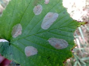

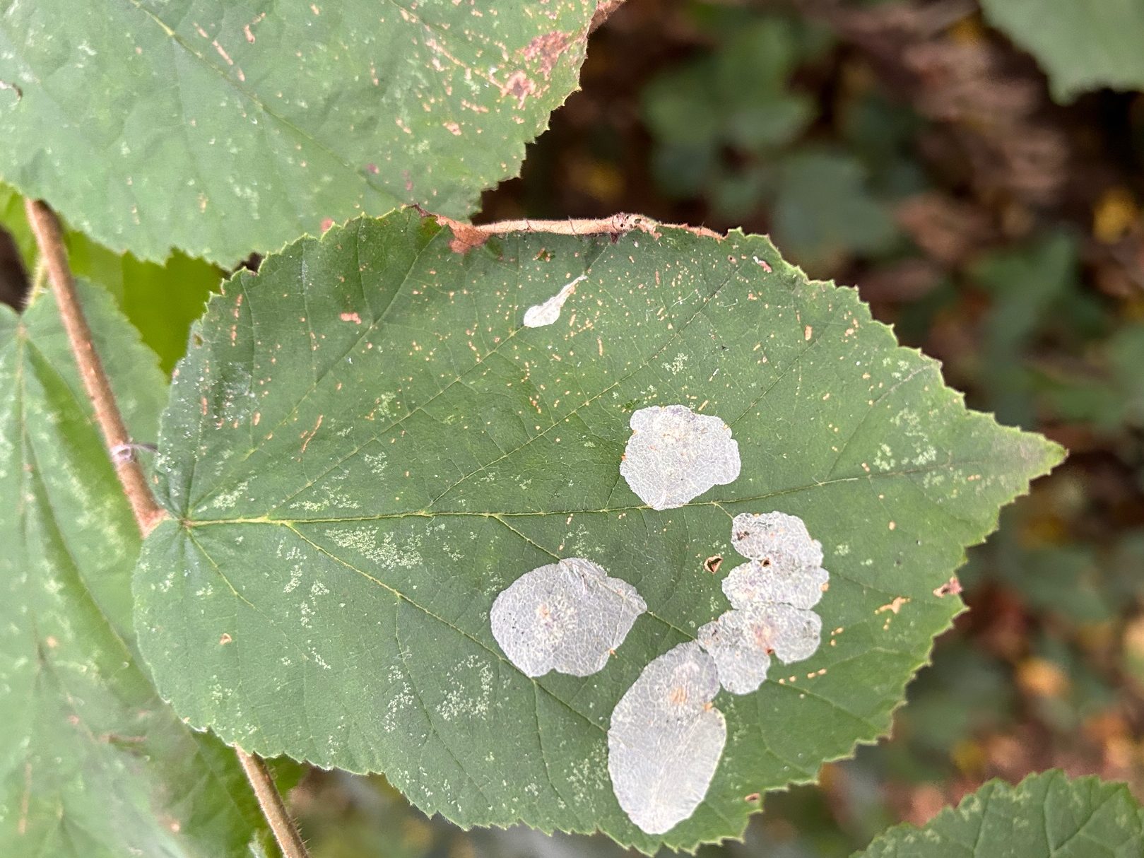


Image Gallery


Temporal Distribution Chart
Adults: (between 2014 - 2025) | Immatures: (between 2001 - 2025)
Distribution Map for Phyllonorycter coryli
↳ from 2026+
↳ 58 from 2020 - 2025
↳ 42 from Before 2020
If the Map Layers function fails, just refresh the page and it should be OK after. Use the +- zoom on the top left, or on a tablet, use two fingers to zoom. Remember, the last layer you ticked is the one which displays the popup information - they sit on top of each other - de-select then re-select, to see the popup values.
Bedrock Geology ** indirectly affects moth distribution by influencing the type of habitat and food plants available in an area. In turn, this may affect the types of moths that can thrive, or where they can most likely be found.
NBN Atlas UK Distribution for – Phyllonorycter coryli
⚠️ Please wait for the map to load fully – do not click the link shown.
Note – the NBN Atlas datasets are listed in the map below and vary in their currency (uptodateness) – however,
the map does give a general indication of the moth's distribution across the UK.
Monthly Records By Year:
Phyllonorycter coryli
( data includes both Larvae and Adult Stages )
Monthly Counts By Year:
Phyllonorycter coryli
( data is based on 'Adult' stage records only )
First/Last Recorded Dates: Phyllonorycter coryli
Adult-only & Anything [Larvae, Pupae, Adult, Mines]
Shading shows moth presence between dates
Click the colour discs below to Select/De-select as Required
Recordings By Year: Phyllonorycter coryli
( All data includes both Larvae and Adult Stages )
Annual Growth Rate (AGR): Phyllonorycter coryli
AGR: 6.15% | Total % Change: 319%
Hectad (10kmx10km) Coverage: Phyllonorycter coryli
( data includes both Larvae and Adult Stages )
Flight Periods – Indicative –vs– Recorded Data
Phyllonorycter coryli
Phyllonorycter coryli
Flight Period chart – the grey hatched area above, which can cross one or more months, pictorially represents the best guess we have for this moth's flight periods [month/s]. The coloured lines represent the actual months seen in flight, from site observation records received between 2020-2026.
Mine Periods – Indicative –vs– Recorded Data
Phyllonorycter coryli
Phyllonorycter coryli
( data includes both Larvae and Adult Stages )
Mine Period chart – the grey hatched area above, which can cross one or more months, pictorially represents the best guess we have for this moth's mine periods [month/s]. The coloured lines represent the actual months seen mining, from site observation records received between 2020-2026.
Records Behind the Map and Charts - Phyllonorycter coryli – 100 records available
Listed by Year - descending - scroll across to see all table columns
| Site Name | Tetrad | Date | Count | Stage | Recorder | Source | RecordKey |
|---|---|---|---|---|---|---|---|
| Harry's Wood, Smisby | SK32K | 13/10/2025 | 1 | Mine | Finch, Graham Leonard | vc57_irecords_extract | iBRC50352001 |
| Darwin Forest | SK26X | 04/10/2025 | 6 | mine (empty) | Evans, Dave | vc57_irecords_extract | iBRC45786884 |
| Markham Vale North Tip | SK47L | 28/09/2025 | 16 | mine | Radford, Mark | vc57_irecords_extract | iBRC45676985 |
| Staveley garden SYA | SK47H | 27/09/2025 | 10 | mine | Radford, Mark | vc57_irecords_extract | iBRC45663984 |
| Bowden Lane, High Peak, England, GB | SK08Q | 19/09/2025 | 1 | Adult | Murdoch, Sue | vc57_irecords_extract | iBRC45434293 |
| Buxton SK, UK | SK07S | 02/09/2025 | 1 | Adult | Orridge, Steve | vc57_irecords_extract | iBRC45034731 |
| Ladybower Reservoir, Derwent Valley | SK18Z | 27/08/2025 | 1 | Leaf-mine | Heintzen, Christian | vc57_irecords_extract | iBRC47521335 |
| Chapel-en-le-Frith, High Peak, England, GB | SK07P | 23/08/2025 | 1 | Adult | Murdoch, Sue | vc57_irecords_extract | iBRC49671928 |
| Meersbrook Park | SK38M | 22/08/2025 | 1 | mine | Mella, Pete | vc57_irecords_extract | iBRC44861237 |
| Beeley to Rowsley | SK26N | 20/08/2025 | 1 | mine | Watchorn, Andrew | vc57_irecords_extract | iBRC44734763 |
| Beeley to Rowsley | SK26N | 20/08/2025 | 1 | mine | Watchorn, Andrew | vc57_irecords_extract | iBRC44734764 |
| Beeley to Rowsley | SK26N | 20/08/2025 | 1 | mine (empty) | Watchorn, Andrew | vc57_irecords_extract | iBRC47566250 |
| DWT Wyver Lane | SK34P | 13/08/2025 | 7 | mine (empty) | Evans, Dave | vc57_irecords_extract | iBRC44440770 |
| DWT Wyver Lane | SK34P | 06/08/2025 | 1 | mine (empty) | Evans, Dave | vc57_irecords_extract | iBRC44213588 |
| Toton Washlands | SK43X | 06/08/2025 | 1 | mine | Bryce, Marion | vc57_irecords_extract | iBRC44249962 |
| Bugsworth Canal Basin | SK08G | 28/07/2025 | 6 | mine | Mortin, Jon | vc57_irecords_extract | iBRC50388100 |
| Gleadless Valley LNR | SK38R | 28/07/2025 | 1 | mine | Mella, Pete | vc57_irecords_extract | iBRC43962142 |
| Gleadless Valley LNR | SK38L | 29/06/2025 | 1 | mine | Mella, Pete | vc57_irecords_extract | iBRC42786784 |
| Cromford Canal | SK35G | 13/06/2025 | 3 | mine | Evans, Dave | vc57_irecords_extract | iBRC42267893 |
| DWT Wyver Lane | SK34P | 10/06/2025 | 7 | mine (tenant | Evans, Dave | vc57_irecords_extract | iBRC42186747 |
| Stanage Edge | SK28G | 03/06/2025 | 20 | mine | Watchorn, Andrew | vc57_irecords_extract | iBRC43426236 |
| Combs Road, Chapel-en-le-Frith | SK07P | 07/11/2024 | 1 | Adult | purplesusieq | vc57_irecords_extract | iBRC39119074 |
| Pottery Wood | SK32G | 05/11/2024 | 1 | Mine | Finch, Graham Leonard | vc57_irecords_extract | iBRC41038958 |
| Pottery Wood | SK32G | 05/11/2024 | 1 | Mine | Finch, Graham Leonard | vc57_irecords_extract | iBRC41038959 |
| Burton upon Trent | SK32P | 05/11/2024 | 1 | Mine | Finch, Graham Leonard | vc57_irecords_extract | iBRC41038912 |
| Poolsbrook, Derbyshire | SK47G | 01/11/2024 | 5 | Adult | Morris, Sid | vc57_irecords_extract | iBRC39049986 |
| Chapel-en-le-Frith, High Peak, England, GB | SK07P | 25/10/2024 | 1 | Adult | purplesusieq | vc57_irecords_extract | iBRC38992285 |
| Derbyshire, UK | SK15K | 20/10/2024 | 1 | Larva | Emmerson, A | vc57_irecords_extract | iBRC39273767 |
| Wash | SK08R | 17/10/2024 | 1 | Larva | purplesusieq | vc57_irecords_extract | iBRC38969805 |
| Calke Abbey | SK32R | 16/10/2024 | 1 | mine | Harvey, Martin C. | vc57_irecords_extract | iBRC38901118 |
| Monsal Trail | SK17B | 15/10/2024 | 1 | mine | Harvey, Martin C. | vc57_irecords_extract | iBRC38900838 |
| Monsall Head | SK17V | 14/10/2024 | 1 | mine | Harvey, Martin C. | vc57_irecords_extract | iBRC38894097 |
| Grinlow Woods (east), Buxton | SK07L | 03/10/2024 | 1 | mine | Mortin, Jon | vc57_irecords_extract | iBRC40534616 |
| Darwin Forest | SK36C | 02/10/2024 | 40 | mine (empty) | Evans, Dave | vc57_irecords_extract | iBRC38743123 |
| Longdendale, Torside carpark | SK09U | 26/09/2024 | 20 | Leaf-mine | Heintzen, Christian | vc57_irecords_extract | iBRC38689422 |
| River Derwent, Derby | SK33S | 21/09/2024 | 1 | mine | Gregory, Neil | vc57_irecords_extract | iBRC38567605 |
| River Derwent, Derby | SK33S | 21/09/2024 | 1 | mine | Gregory, Neil | vc57_irecords_extract | iBRC38567621 |
| Longford | SK23I | 16/09/2024 | 20 | mine | Peter Hall | vc57_irecords_extract | iBRC38492202 |
| DWT Wyver Lane | SK34P | 12/09/2024 | 12 | mine (empty) | Evans, Dave | vc57_irecords_extract | iBRC38431751 |
| Minster | SK26K | 11/09/2024 | 1 | Mine | Jack Oughton | vc57_irecords_extract | iBRC39791131 |
| DWT Wyver Lane | SK34P | 04/09/2024 | 3 | mine (empty) | Evans, Dave | vc57_irecords_extract | iBRC38312444 |
| Deep Dale, Topley Pike | SK17B | 31/08/2024 | 1 | Adult | Mortin, Jon | vc57_irecords_extract | iBRC38241881 |
| Gleadless Valley LNR | SK38L | 25/08/2024 | 1 | Adult | Mella, Pete | vc57_irecords_extract | iBRC38093863 |
| Cromford Canal | SK35G | 18/08/2024 | 7 | mine (empty) | Evans, Dave | vc57_irecords_extract | iBRC38116492 |
| Coombs Dale, Stoney Middleton | SK27H | 21/07/2024 | 1 | Adult | Bird, Jackson | vc57_irecords_extract | iBRC37756672 |
| Coombs Dale, Stoney Middleton | SK27H | 21/07/2024 | 1 | Larva | Emmerson, A | vc57_irecords_extract | iBRC38857214 |
| Long Wood, Moss Valley | SK38Q | 07/07/2024 | 1 | mine | Mella, Pete | vc57_irecords_extract | iBRC43107905 |
| Poppy Wood | SK32S | 22/11/2023 | 1 | Mine | Finch, Graham Leonard | vc57_irecords_extract | iBRC35107067 |
| Calke Park | SK32R | 01/10/2023 | 1 | Mine | Finch, Graham Leonard | vc57_irecords_extract | iBRC35105544 |
| Carver's Rocks | SK32G | 30/09/2023 | 1 | Mine | Finch, Graham Leonard | vc57_irecords_extract | iBRC35106089 |
| Carver's Rocks | SK32H | 21/09/2023 | 1 | Mine | Finch, Graham Leonard | vc57_irecords_extract | iBRC35106113 |
| Moss Valley, Dronfield | SK38V | 10/09/2023 | 1 | Larva | floriang | vc57_irecords_extract | iBRC38851845 |
| Etherow Country Park, Stockport, England, GB | SJ99Q | 03/09/2023 | 1 | Larva | tangshuttfriend | vc57_irecords_extract | iBRC33946456 |
| Allestree Park | SK34K | 25/09/2022 | 1 | Mine | Finch, Graham Leonard | vc57_irecords_extract | iBRC35105370 |
| Former Saint-Gobain Pipeworks, Staveley [centroid] | SK47C | 20/10/2020 | 1 | Adult | Godfrey, A. | vc57_irecords_extract | iBRC33989198 |
| Birch Vale | SK08I | 28/09/2020 | 1 | Leaf-mine | Hewitt, Jane | vc57_irecords_extract | iBRC35067591 |
| Allestree, Derby | SK33P | 17/09/2020 | 4 | mine | Plant, Stephen | vc57_irecords_extract | iBRC46558625 |
| Buxton SK, UK | SK07S | 30/07/2020 | 1 | Larva | Orridge, Steve | vc57_irecords_extract | iBRC38886466 |
| Calver and River Derwent | SK27M | 08/10/2018 | 10 | Adult | Watchorn, Andrew | vc57_irecords_extract | iBRC8618488 |
| Grange Wood | SK21S | 13/09/2018 | 1 | Mine | Finch, Graham Leonard | vc57_irecords_extract | iBRC35106443 |
| Beeley to Rowsley | SK26T | 27/07/2017 | 5 | Larva | Watchorn, Andrew | vc57_irecords_extract | iBRC5504909 |
| Coombs Dale, Calver | SK27H | 17/07/2017 | 1 | Larva | Watchorn, Andrew | vc57_irecords_extract | iBRC5443531 |
| Burrs Wood, Cordwell Valley | SK37C | 01/11/2015 | 2 | mine (tenant | Watchorn, Andrew | vc57_irecords_extract | iBRC32703347 |
| Jim Mart Nature Reserve | SK36S | 17/10/2015 | 1 | Mine | Mahadevan, Nikki | vc57_irecords_extract | iBRC34908042 |
| Thorntree Lane,Newhall,Swadlincote | SK22V | 12/10/2015 | 2 | Larval Mine | Dave Budworth | vc57_danes_bc_data | LC000334001COV5A |
| Markeaton Park,Derby | SK33I | 17/10/2014 | 1 | Larval Mine | Dave Budworth;D.A. Clarke | vc57_danes_bc_data | LC000334001CP9MR |
| Coton Wood, Coton in the Elms, Swadlincote | SK21M | 21/09/2014 | 6 | Larval Mine | Dave Budworth | vc57_danes_bc_data | LC000334001COV3S |
| Coton Wood, Coton in the Elms, Swadlincote | SK21M | 21/09/2014 | 6 | Larval Mine | Dave Budworth | vc57_danes_bc_data | LC000334001COV3V |
| Coton Wood, Coton in the Elms, Swadlincote | SK21M | 21/09/2014 | 6 | Adult | Dave Budworth | vc57_danes_bc_data | LC000334001COV3W |
| Foremark Resr, Ticknall | SK32G | 16/09/2014 | 6 | Larval Mine | Dave Budworth | vc57_danes_bc_data | LC000334001COV3I |
| Millennium Meadow NR, Duffield | SK34L | 09/07/2014 | 1 | Larval Mine | VC57 Derbyshire Recorder | vc57_danes_bc_data | LC000334001COYWW |
| Robin Wood, Ticknall | SK32M | 01/09/2013 | 1 | Larval Mine | Dave Budworth | vc57_danes_bc_data | LC000334001COYTW |
| Carvers Rocks,Hartshorne | SK32G | 18/09/2011 | 1 | Larval Mine | Dave Budworth | vc57_danes_bc_data | LC000334001CP7MT |
| Millers Dale | SK17G | 03/09/2011 | 1 | Larval Mine | S.H. Hind | vc57_danes_bc_data | LC000334001CP7LJ |
| Carvers Rocks, Hartshorne, Swadlincote | SK32G | 24/10/2010 | 2 | Larval Mine | Dave Budworth | vc57_danes_bc_data | LC000334001COTRD |
| Avenue Washlands NR, Wingerworth | SK36Y | 16/10/2010 | 1 | Larval Mine | Dave Budworth | vc57_danes_bc_data | LC000334001COTR9 |
| Derbyshire, UK | SK16Z | 22/09/2010 | 1 | Larva | Orridge, Steve | vc57_irecords_extract | iBRC23065243 |
| Ashford in the Water | SK16Z | 22/09/2010 | 1 | Larval Mine | S.A. Orridge;S.H. Hind | vc57_danes_bc_data | LC000334001CP6OS |
| Ashford in the Water | SK16Z | 22/09/2010 | 1 | Larval Mine | S.A. Orridge;S.H. Hind | vc57_danes_bc_data | LC000334001CP6PF |
| Bamford | SK28B | 21/09/2010 | 1 | Larval Mine | K. McCabe;S.H. Hind | vc57_danes_bc_data | LC000334001COTPP |
| Ladybower Resr | SK18U | 03/09/2010 | 1 | Larval Mine | S.H. Hind | vc57_danes_bc_data | LC000334001CP6L1 |
| Hopton Wood NR, Cromford | SK25T | 16/10/2009 | 1 | Larval Mine | Dave Budworth;S.A. Orridge;S.H. Hind | vc57_danes_bc_data | LC000334001COT0W |
| Cromford | SK25Y | 16/10/2009 | 1 | Larval Mine | Dave Budworth;S.A. Orridge;S.H. Hind | vc57_danes_bc_data | LC000334001CP560 |
| Linacre | SK37L | 13/10/2009 | 1 | Larval Mine | S.H. Hind | vc57_danes_bc_data | LC000334001CP552 |
| Coombs Dale,Stoney Middleton | SK27H | 12/10/2009 | 1 | Larval Mine | S.H. Hind | vc57_danes_bc_data | LC000334001COWZ0 |
| Coombs Dale,Stoney Middleton | SK27H | 12/10/2009 | 1 | Larval Mine | S.H. Hind | vc57_danes_bc_data | LC000334001CP540 |
| Hope | SK18R | 07/10/2009 | 1 | Larval Mine | S.H. Hind | vc57_danes_bc_data | LC000334001COSZE |
| Carvers Rocks NR,Hartshorne | SK32G | 03/10/2009 | 10 | Larval Mine | Dave Budworth | vc57_danes_bc_data | LC000334001CP068 |
| Foremark Resr (sailing club area), Ticknall | SK32H | 02/10/2009 | 2 | Larval Mine | Dave Budworth | vc57_danes_bc_data | LC000334001CP064 |
| Tissington Trail, Ashbourne | SK14T | 01/10/2009 | 1 | Larval Mine | Dave Budworth;S.A. Orridge;S.H. Hind | vc57_danes_bc_data | LC000334001COWYT |
| Nether Hall Wood, Hartshorne | SK32A | 18/09/2009 | 2 | Larval Mine | Dave Budworth | vc57_danes_bc_data | LC000334001CP05I |
| Calke Park | SK32L | 25/10/2008 | 1 | Mine | Finch, Graham Leonard | vc57_irecords_extract | iBRC35105484 |
| Calke Park,Ticknall | SK32R | 25/10/2008 | 1 | Larval Mine | VC57 Derbyshire Recorder | vc57_danes_bc_data | LC000334001COSOI |
| Badger Wood, Caldwell | SK21T | 05/10/2008 | 2 | Larval Mine | Dave Budworth | vc57_danes_bc_data | LC000334001COZY6 |
| Monsall Trail, Buxton | SK17L | 14/09/2008 | 1 | Larval Mine | S.H. Hind | vc57_danes_bc_data | LC000334001COSNO |
| Shallcross Wood, Goyt Valley, Whaley Bridge | SK07E | 26/09/2006 | 1 | Larval Mine | S.H. Hind | vc57_danes_bc_data | LC000334001CP9Y9 |
| Carr Vale NR,Bolsover | SK47K | 13/09/2006 | 1 | Larval Mine | S.H. Hind | vc57_danes_bc_data | LC000334001CP3N4 |
| Ogston Carr Wood,nr Ogston Res | SK35U | 12/07/2006 | 1 | Larval Mine | S.H. Hind | vc57_danes_bc_data | LC000334001CORSH |
| Clattercotes Wood, nr Ogston Resr | SK36K | 12/07/2006 | 1 | Larval Mine | S.H. Hind | vc57_danes_bc_data | LC000334001CP366 |
| Abbotsholme School, Rocester | SK13E | 04/10/2001 | 1 | Larval Mine | S.H. Hind | vc57_danes_bc_data | LC000334001COVGS |