
 – click for General Verification Guidelines | – click for Specific Verification Guidelines
  – Generally Common / Widespread
Blue-coded] moths is not displayed/updated in this tab. However, all verified records for this moth are listed in the RECORDS tab below. 


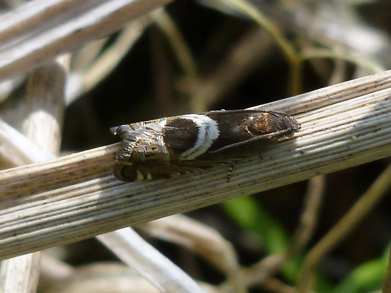
Image Gallery


Temporal Distribution Chart
Adults: (between 1905 - 2026)
Distribution Map for Grapholita jungiella
↳ 23 from 2026+
↳ 30 from 2020 - 2025
↳ 32 from Before 2020
If the Map Layers function fails, just refresh the page and it should be OK after. Use the +- zoom on the top left, or on a tablet, use two fingers to zoom. Remember, the last layer you ticked is the one which displays the popup information - they sit on top of each other - de-select then re-select, to see the popup values.
Bedrock Geology ** indirectly affects moth distribution by influencing the type of habitat and food plants available in an area. In turn, this may affect the types of moths that can thrive, or where they can most likely be found.
NBN Atlas UK Distribution for – Grapholita jungiella
⚠️ Please wait for the map to load fully – do not click the link shown.
Note – the NBN Atlas datasets are listed in the map below and vary in their currency (uptodateness) – however,
the map does give a general indication of the moth's distribution across the UK.
Monthly Records By Year:
Grapholita jungiella
( data includes both Larvae and Adult Stages )
Monthly Counts By Year:
Grapholita jungiella
( data is based on 'Adult' stage records only )
First/Last Recorded Dates: Grapholita jungiella
Adult-only & Anything [Larvae, Pupae, Adult, Mines]
Shading shows moth presence between dates
Click the colour discs below to Select/De-select as Required
Recordings By Year: Grapholita jungiella
( All data includes both Larvae and Adult Stages )
Annual Growth Rate (AGR): Grapholita jungiella
AGR: 3.4% | Total % Change: 108.7%
Hectad (10kmx10km) Coverage: Grapholita jungiella
( data includes both Larvae and Adult Stages )
Flight Periods – Indicative –vs– Recorded Data
Grapholita jungiella
Grapholita jungiella
Flight Period chart – the grey hatched area above, which can cross one or more months, pictorially represents the best guess we have for this moth's flight periods [month/s]. The coloured lines represent the actual months seen in flight, from site observation records received between 2020-2026.
Records Behind the Map and Charts - Grapholita jungiella – 85 records available
Listed by Year - descending - scroll across to see all table columns
| Site Name | Tetrad | Date | Count | Stage | Recorder | Source | RecordKey |
|---|---|---|---|---|---|---|---|
| Arkwright Pit | SK47F | 29/05/2026 | 1 | adult | Radford, Mark | vc57_irecords_extract | iBRC52771061 |
| rose end meadows | SK25Y | 28/05/2026 | 3 | adult | Ashton, Clive | vc57_irecords_extract | iBRC52740146 |
| DWT Wyver Lane | SK34P | 26/05/2026 | 1 | adult | Evans, Dave | vc57_irecords_extract | iBRC52681145 |
| Heage | SK34U | 23/05/2026 | 1 | adult | Evans, Dave | vc57_irecords_extract | iBRC52541245 |
| Heage | SK34U | 22/05/2026 | 1 | adult | Evans, Dave | vc57_irecords_extract | iBRC52488961 |
| rose end meadows | SK25Y | 21/05/2026 | 10 | adult | Ashton, Clive | vc57_irecords_extract | iBRC52472766 |
| DWT Wyver Lane | SK34P | 06/05/2026 | 1 | adult | Evans, Dave | vc57_irecords_extract | iBRC52026408 |
| Ladycroft Ave, Buxton | SK07S | 03/05/2026 | 1 | adult | Orridge, Steve | vc57_irecords_extract | iBRC53157509 |
| Ladycroft Ave, Buxton | SK07S | 01/05/2026 | 1 | adult | Orridge, Steve | vc57_irecords_extract | iBRC51907851 |
| Ladycroft Ave, Buxton | SK07S | 01/05/2026 | 1 | adult | Orridge, Steve | vc57_irecords_extract | iBRC53157419 |
| DWT Wyver Lane | SK34P | 30/04/2026 | 1 | adult | Evans, Dave | vc57_irecords_extract | iBRC51832853 |
| DWT Wyver Lane | SK34P | 30/04/2026 | 1 | adult | Evans, Dave | vc57_irecords_extract | iBRC51833251 |
| DWT Wyver Lane | SK34P | 29/04/2026 | 1 | adult | Evans, Dave | vc57_irecords_extract | iBRC51812450 |
| Ladycroft Ave, Buxton | SK07S | 26/04/2026 | 1 | adult | Orridge, Steve | vc57_irecords_extract | iBRC51849232 |
| Hall Lane Pond | SK47H | 24/04/2026 | 11 | adult | Radford, Mark | vc57_irecords_extract | iBRC51651733 |
| Holloway | SK35I | 23/04/2026 | 2 | adult | Pritchard, Alison | vc57_irecords_extract | iBRC51642199 |
| DWT Wyver Lane | SK34P | 22/04/2026 | 1 | adult | Evans, Dave | vc57_irecords_extract | iBRC51609251 |
| Markham Vale South Tip | SK47K | 19/04/2026 | 3 | adult | Radford, Mark | vc57_irecords_extract | iBRC51550504 |
| DWT Wyver Lane | SK34P | 16/04/2026 | 1 | adult | Evans, Dave | vc57_irecords_extract | iBRC51492157 |
| Hall Lane Pond | SK47H | 13/04/2026 | 2 | adult | Radford, Mark | vc57_irecords_extract | iBRC51436129 |
| DWT Wyver Lane | SK34P | 07/04/2026 | 1 | adult | Evans, Dave | vc57_irecords_extract | iBRC51349160 |
| rose end meadows | SK25Y | 06/04/2026 | 1 | adult | Ashton, Clive | vc57_irecords_extract | iBRC51327163 |
| Hall Lane Pond | SK47H | 06/04/2026 | 1 | adult | Radford, Mark | vc57_irecords_extract | iBRC51384253 |
| Ladycroft Ave, Buxton | SK07S | 19/06/2025 | 1 | Adult | Orridge, Steve | vc57_irecords_extract | iBRC42579812 |
| DWT Wyver Lane | SK34P | 03/06/2025 | 3 | Adult | Evans, Dave | vc57_irecords_extract | iBRC42045921 |
| DWT Wyver Lane | SK34P | 28/05/2025 | 2 | Adult | Evans, Dave | vc57_irecords_extract | iBRC41951143 |
| Longdendale, Wildboar Clough Woodland | SK09U | 20/05/2025 | 1 | Adult | Heintzen, Christian | vc57_irecords_extract | iBRC43979240 |
| DWT Wyver Lane | SK34P | 20/05/2025 | 3 | Adult | Evans, Dave | vc57_irecords_extract | iBRC41723679 |
| Cunningdale, Buxton | SK07R | 18/05/2025 | 1 | Adult | Taylor, Sue | vc57_irecords_extract | iBRC42060859 |
| Deep Dale (DWT reserve) | SK07V | 18/05/2025 | 2 | Adult | Hewitt, Jane | vc57_irecords_extract | iBRC48232885 |
| CheeDale Quarry Reserve | SK17G | 17/05/2025 | 1 | Adult | Taylor, Sue | vc57_irecords_extract | iBRC41864988 |
| Chee Dale, Station Quarry | SK17G | 17/05/2025 | 1 | Adult | Hewitt, Jane | vc57_irecords_extract | iBRC48232875 |
| Markham Vale South Tip , Derbyshire | SK47K | 16/05/2025 | 1 | Adult | Morris, Sid | vc57_irecords_extract | iBRC41631327 |
| Rose End Meadows, Cromford | SK25Y | 15/05/2025 | 2 | Adult | Fletcher, Neil | vc57_irecords_extract | iBRC48197955 |
| DWT Wyver Lane | SK34P | 13/05/2025 | 2 | Adult | Evans, Dave | vc57_irecords_extract | iBRC41552145 |
| National Stone Centre, Wirksworth. | SK25X | 09/05/2025 | 2 | Adult | Evans, Dave | vc57_irecords_extract | iBRC41493531 |
| Markham Vale Derbyshire | SK47L | 07/05/2025 | 1 | Adult | Morris, Sid | vc57_irecords_extract | iBRC41414336 |
| Markham Vale North Tip | SK47L | 07/05/2025 | 1 | Adult | Radford, Mark | vc57_irecords_extract | iBRC41438824 |
| LUDWORTH MOOR | SJ99V | 01/05/2025 | 10 | Adult | BISSITT, ANDREW | vc57_irecords_extract | iBRC42134676 |
| rose end meadows | SK25Y | 25/04/2025 | 6 | Adult | Ashton, Clive | vc57_irecords_extract | iBRC41140477 |
| LUDWORTH MOOR | SJ99V | 09/05/2024 | 1 | Adult | BISSITT, ANDREW | vc57_irecords_extract | iBRC35845903 |
| DWT Wyver Lane | SK34P | 07/06/2023 | 1 | Adult | Evans, Dave | vc57_irecords_extract | iBRC35307856 |
| Derbyshire Wild Life Trust Long Clough | SK09G | 16/05/2023 | 1 | Adult | Heintzen, Christian | vc57_irecords_extract | iBRC36335955 |
| Derbyshire Wild Life Trust Long Clough | SK09G | 08/05/2023 | 4 | Adult | Heintzen, Christian | vc57_irecords_extract | iBRC36335902 |
| Ladycroft Ave | SK07S | 07/05/2023 | 1 | Adult | Orridge, Steve | vc57_irecords_extract | iBRC35075899 |
| Hopton Quarry | SK25T | 07/05/2022 | 1 | Adult | Marriott, Ant | vc57_irecords_extract | iBRC25346693 |
| Hoe Grange Quarry | SK25I | 30/04/2022 | 3 | Adult | Allen, Ian | vc57_irecords_extract | iBRC25144801 |
| Birch Vale | SK08I | 02/06/2021 | 1 | Adult | Hewitt, Jane | vc57_irecords_extract | iBRC34472621 |
| Birch Vale | SK08I | 12/05/2021 | 1 | Adult | Hewitt, Jane | vc57_irecords_extract | iBRC34472620 |
| Birch Vale | SK08I | 18/05/2020 | 1 | Adult | Hewitt, Jane | vc57_irecords_extract | iBRC35066323 |
| Jim Mart Nature Reserve | SK36S | 18/05/2020 | 1 | Adult | Mahadevan, Nikki | vc57_irecords_extract | iBRC34919197 |
| Ladycroft Ave, Buxton | SK07S | 17/05/2020 | 1 | Adult | Orridge, Steve | vc57_irecords_extract | iBRC35094783 |
| Birch Vale | SK08I | 09/05/2020 | 1 | Adult | Hewitt, Jane | vc57_irecords_extract | iBRC35067554 |
| Jim Mart Nature Reserve | SK36S | 23/05/2019 | 1 | Adult | Mahadevan, Nikki | vc57_irecords_extract | iBRC34919010 |
| Birch Vale | SK08I | 20/05/2019 | 1 | Adult | Hewitt, Jane | vc57_irecords_extract | iBRC35073510 |
| Jim Mart Nature Reserve | SK36S | 27/04/2019 | 1 | Adult | Mahadevan, Nikki | vc57_irecords_extract | iBRC34919187 |
| Ladycroft Ave | SK07S | 07/05/2018 | 1 | Adult | Orridge, Steve | vc57_irecords_extract | iBRC49165670 |
| Jim Mart Nature Reserve | SK36S | 01/05/2018 | 1 | Adult | Mahadevan, Nikki | vc57_irecords_extract | iBRC34917399 |
| Ladycroft Ave | SK07S | 11/05/2016 | 1 | Adult | Orridge, Steve | vc57_irecords_extract | iBRC41044438 |
| Ladycroft Ave | SK07S | 21/05/2015 | 1 | Adult | Orridge, Steve | vc57_irecords_extract | iBRC48845450 |
| Jim Mart Nature Reserve | SK36S | 21/05/2015 | 1 | Adult | Mahadevan, Nikki | vc57_irecords_extract | iBRC34907970 |
| Langley Mill Tip, Amber Drive | SK44N | 17/05/2015 | 1 | Adult | Thorpe, Steve | vc57_irecords_extract | iBRC33505328 |
| Jim Mart Nature Reserve | SK36S | 04/05/2015 | 2 | Adult | Mahadevan, Nikki | vc57_irecords_extract | iBRC34907969 |
| nr Erewash Canal, Sandiacre | SK43T | 14/04/2015 | 1 | Adult | VC57 Derbyshire Recorder | vc57_danes_bc_data | LC000334001CP9MZ |
| Padley Gorge (Longshaw Est) | SK27P | 03/06/2013 | 10 | Adult | D. Mcgeever | vc57_danes_bc_data | LC000334001COUQL |
| Grin Plantation, Buxton | SK07L | 21/05/2012 | 1 | Adult | K.R. Huston | vc57_danes_bc_data | LC000334001COY1T |
| Clough Wood,Darley Dale | SK26K | 29/04/2011 | 1 | Adult | K.R. Huston | vc57_danes_bc_data | LC000334001CP6U0 |
| Ladycroft Ave,Buxton | SK07S | 22/04/2011 | 1 | Adult | Orridge, Steve | vc57_danes_bc_data | LC000334001COXLK |
| Clough Wood,Darley Dale | SK26K | 17/04/2011 | 20 | Adult | A. Butler | vc57_danes_bc_data | LC000334001CP6T0 |
| Ladycroft Ave,Buxton | SK07S | 21/05/2010 | 2 | Adult | Orridge, Steve | vc57_danes_bc_data | LC000334001CP59N |
| Ladycroft Ave,Buxton | SK07S | 19/05/2010 | 1 | Adult | Orridge, Steve | vc57_danes_bc_data | LC000334001COX1J |
| Ladycroft Ave,Buxton | SK07S | 05/05/2010 | 1 | Adult | Orridge, Steve | vc57_danes_bc_data | LC000334001CP589 |
| Stainsby Park,Glapwell | SK46S | 10/06/2008 | 5 | Adult | M.E. Bradley | vc57_danes_bc_data | LC000334001CP48A |
| Bristol Rd,Ilkeston | SK44R | 19/05/2008 | 1 | Adult | S.L.P. Whiteley | vc57_danes_bc_data | LC000334001CP46N |
| Ladycroft Ave,Buxton | SK07S | 17/05/2007 | 1 | Adult | Orridge, Steve | vc57_danes_bc_data | LC000334001CP3RR |
| Ladycroft Ave,Buxton | SK07S | 21/04/2007 | 1 | Adult | Orridge, Steve | vc57_danes_bc_data | LC000334001CP3R1 |
| Seventy Acre Woods/Flash Lane, Derbyshire | SK26Y | 23/06/2005 | 3 | Adult | Finch, Graham Leonard | vc57_irecords_extract | iBRC35107091 |
| Beeley (Seventy Acre Wood) | SK26Y | 23/06/2005 | 3 | Adult | Finch, Graham Leonard | vc57_danes_bc_data | LC000334001COVSM |
| Buxton SK, UK | SK07S | 10/05/2004 | 1 | Adult | Orridge, Steve | vc57_irecords_extract | iBRC29269110 |
| Hopton Wood Quarry (site not precise) | SK25M | 25/05/1995 | 1 | Adult | VC57 Derbyshire Recorder | vc57_danes_bc_data | LC000334001CP15V |
| Clough Wood,Darley Dale | SK26K | 27/04/1993 | 1 | Adult | VC57 Derbyshire Recorder | vc57_danes_bc_data | LC000334001CP0ZX |
| Mapperley NR, Mapperley, Ilkeston | SK44G | 07/06/1981 | 1 | Adult | VC57 Derbyshire Recorder | vc57_danes_bc_data | LC000334001COZJZ |
| Lathkill Dale, Haddon Grove, Bakewell | SK16Y | 25/05/1970 | 1 | Adult | VC57 Derbyshire Recorder | vc57_danes_bc_data | LC000334001COQI7 |
| Beeley Moor, Beeley (site not precise) | SK26Z | 18/05/1905 | 1 | Adult | VC57 Derbyshire Recorder | vc57_danes_bc_data | LC000334001COQHC |
| Troway Wood, Ford | SK37Z | 18/05/1905 | 4 | Adult | VC57 Derbyshire Recorder | vc57_danes_bc_data | LC000334001COQHD |