
 – click for General Verification Guidelines | – click for Specific Verification Guidelines
  – Generally Common / Widespread
Confusion Species: Acleris effractana
Blue-coded] moths is not displayed/updated in this tab. However, all verified records for this moth are listed in the RECORDS tab below. 


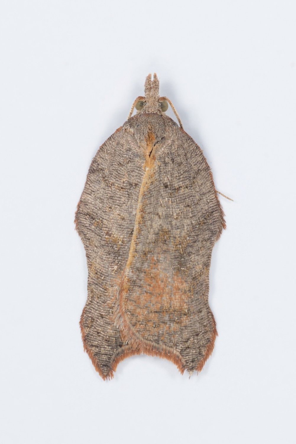
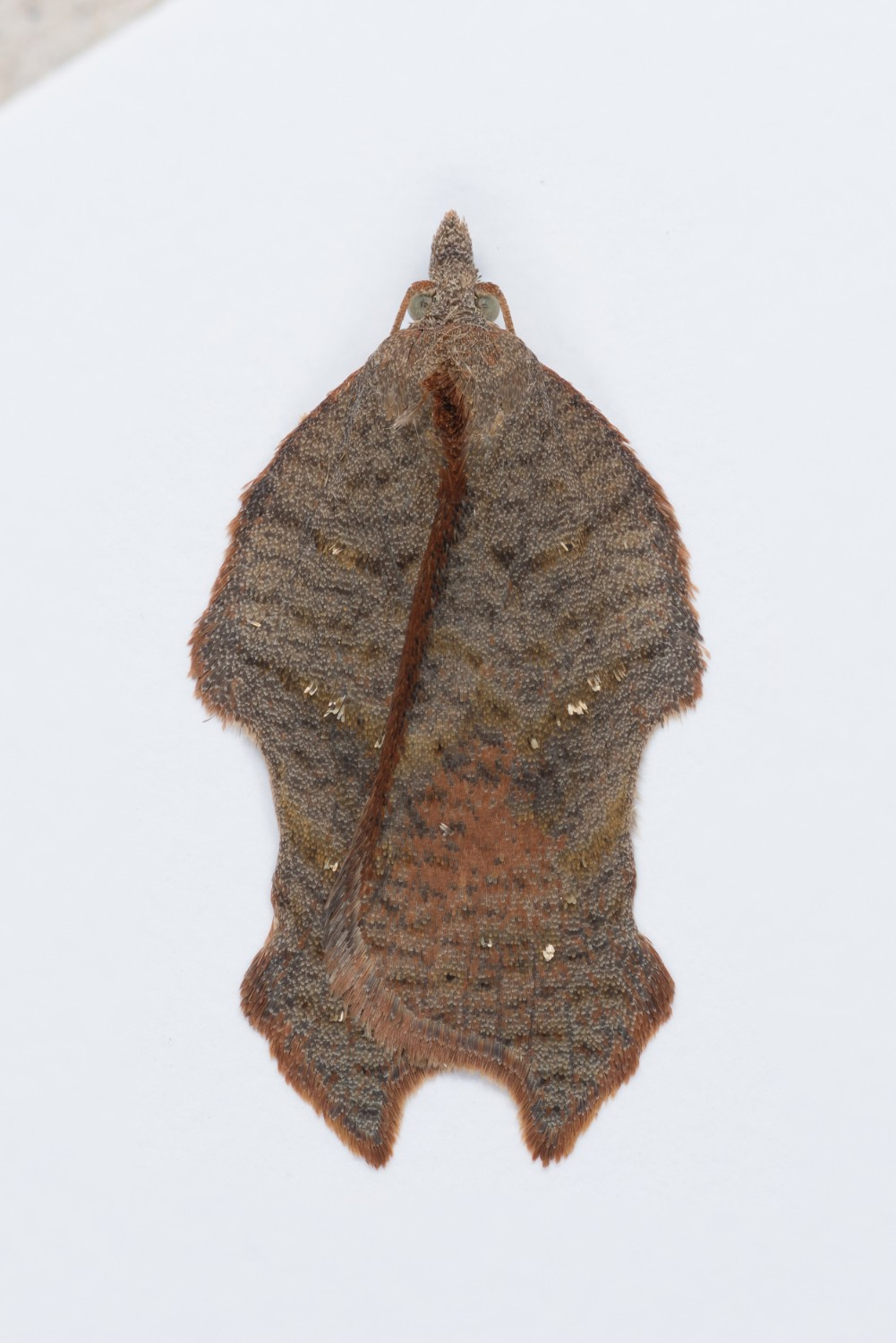
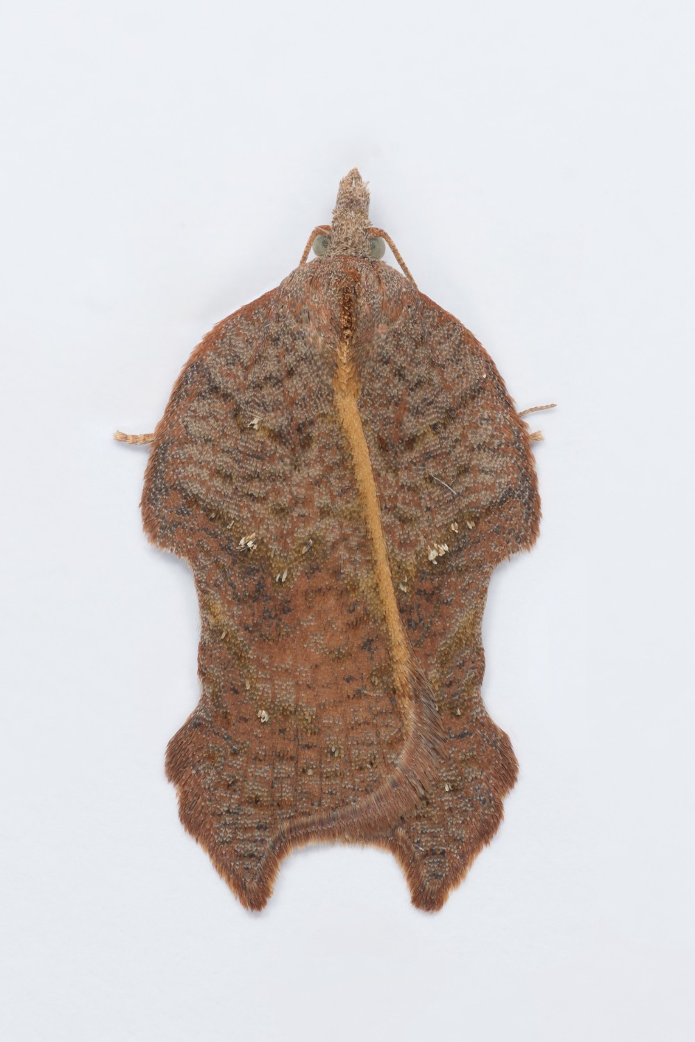
Image Gallery


Temporal Distribution Chart
Adults: (between 1981 - 2025) | Immatures: (between 2025 - 2025)
Distribution Map for Acleris emargana
↳ from 2026+
↳ 49 from 2020 - 2025
↳ 53 from Before 2020
If the Map Layers function fails, just refresh the page and it should be OK after. Use the +- zoom on the top left, or on a tablet, use two fingers to zoom. Remember, the last layer you ticked is the one which displays the popup information - they sit on top of each other - de-select then re-select, to see the popup values.
Bedrock Geology ** indirectly affects moth distribution by influencing the type of habitat and food plants available in an area. In turn, this may affect the types of moths that can thrive, or where they can most likely be found.
NBN Atlas UK Distribution for – Acleris emargana
⚠️ Please wait for the map to load fully – do not click the link shown.
Note – the NBN Atlas datasets are listed in the map below and vary in their currency (uptodateness) – however,
the map does give a general indication of the moth's distribution across the UK.
Monthly Records By Year:
Acleris emargana
( data includes both Larvae and Adult Stages )
Monthly Counts By Year:
Acleris emargana
( data is based on 'Adult' stage records only )
First/Last Recorded Dates: Acleris emargana
Adult-only & Anything [Larvae, Pupae, Adult, Mines]
Shading shows moth presence between dates
Click the colour discs below to Select/De-select as Required
Recordings By Year: Acleris emargana
( All data includes both Larvae and Adult Stages )
Annual Growth Rate (AGR): Acleris emargana
AGR: 1.02% | Total % Change: 25%
Hectad (10kmx10km) Coverage: Acleris emargana
( data includes both Larvae and Adult Stages )
Flight Periods – Indicative –vs– Recorded Data
Acleris emargana
Acleris emargana
Flight Period chart – the grey hatched area above, which can cross one or more months, pictorially represents the best guess we have for this moth's flight periods [month/s]. The coloured lines represent the actual months seen in flight, from site observation records received between 2020-2026.
Records Behind the Map and Charts - Acleris emargana – 102 records available
Listed by Year - descending - scroll across to see all table columns
| Site Name | Tetrad | Date | Count | Stage | Recorder | Source | RecordKey |
|---|---|---|---|---|---|---|---|
| Staveley garden SYA | SK47H | 21/10/2025 | 1 | Adult | Radford, Mark | vc57_irecords_extract | iBRC46031624 |
| High Leas Farm | SK35D | 18/10/2025 | 1 | Adult | Thorpe, Steve | vc57_irecords_extract | iBRC48402263 |
| Ladycroft Ave, Buxton | SK07S | 17/10/2025 | 1 | Adult | Orridge, Steve | vc57_irecords_extract | iBRC48225139 |
| Darwin Forest | SK26X | 06/10/2025 | 1 | Adult | Evans, Dave | vc57_irecords_extract | iBRC45836211 |
| Ladycroft Ave, Buxton | SK07S | 30/09/2025 | 1 | Adult | Orridge, Steve | vc57_irecords_extract | iBRC48224963 |
| Staveley garden SYA | SK47H | 30/09/2025 | 2 | Adult | Radford, Mark | vc57_irecords_extract | iBRC45731599 |
| Belper | SK34U | 18/09/2025 | 1 | pupa | Evans, Dave | vc57_irecords_extract | iBRC45469401 |
| Ladycroft Ave, Buxton | SK07S | 16/09/2025 | 1 | not recorded | Orridge, Steve | vc57_irecords_extract | iBRC48224779 |
| Norton Lees, Sheffield | SK38L | 12/09/2025 | 1 | Adult | Mella, Pete | vc57_irecords_extract | iBRC45437530 |
| Longdendale, Wildboar Clough Woodland | SK09U | 02/09/2025 | 1 | Adult | Heintzen, Christian | vc57_irecords_extract | iBRC48787608 |
| Shaw Farm, New Mills VC | SJ98Y | 31/08/2025 | 1 | Adult | Hind, Steve | vc57_irecords_extract | iBRC44983934 |
| Forbes Hole LNR | SK43W | 25/08/2025 | 1 | Adult | Bryce, Marion | vc57_irecords_extract | iBRC44920479 |
| Stoney Clouds, meadow | SK43T | 23/08/2025 | 1 | Adult | Bryce, Marion | vc57_irecords_extract | iBRC44732186 |
| Staveley Derbyshire | SK47H | 17/08/2025 | 1 | Adult | Morris, Sid | vc57_irecords_extract | iBRC44648361 |
| Platt Street Bottom, Padfield, Glossop SKEB, UK | SK09I | 13/08/2025 | 1 | Adult | Lees, Alexander | vc57_irecords_extract | iBRC44425338 |
| Chisworth, Ludworth Moor | SJ99V | 12/08/2025 | 3 | Adult | Heintzen, Christian | vc57_irecords_extract | iBRC48740449 |
| Jim Mart Nature Reserve | SK36S | 11/08/2025 | 1 | Adult | Mahadevan, Nikki | vc57_irecords_extract | iBRC44470892 |
| Derbyshire Wild Life Trust Long Clough | SK09G | 08/08/2025 | 2 | Adult | Heintzen, Christian | vc57_irecords_extract | iBRC48729367 |
| Miller's Dale, woodland near station | SK17G | 06/09/2024 | 4 | Adult | Steven Bell | vc57_irecords_extract | iBRC40548962 |
| Ladycroft Ave, Buxton | SK07S | 03/09/2024 | 1 | Adult | Orridge, Steve | vc57_irecords_extract | iBRC38801782 |
| Ludworth Moor | SJ99V | 24/08/2024 | 1 | Adult | Heintzen, Christian | vc57_irecords_extract | iBRC38473388 |
| Spring Lakes | SK53A | 15/08/2024 | 1 | Adult | Neil Gregory | vc57_irecords_extract | iBRC37908673 |
| Torside Reservoir northeast end | SK09U | 03/08/2024 | 2 | Adult | Heintzen, Christian | vc57_irecords_extract | iBRC38472764 |
| Staveley Derbyshire | SK47H | 29/09/2023 | 2 | Adult | Morris, Sid | vc57_irecords_extract | iBRC33236331 |
| Ladycroft Ave | SK07S | 20/09/2023 | 1 | Adult | Orridge, Steve | vc57_irecords_extract | iBRC35076746 |
| Ladycroft Ave | SK07S | 13/09/2023 | 1 | Adult | Orridge, Steve | vc57_irecords_extract | iBRC35076345 |
| Buxton SK, UK | SK07S | 02/09/2023 | 1 | Adult | Orridge, Steve | vc57_irecords_extract | iBRC33310513 |
| Markham Vale , Seymour , Derbyshire | SK47L | 30/08/2023 | 1 | Adult | Morris, Sid | vc57_irecords_extract | iBRC32741300 |
| Ladycroft Ave | SK07S | 24/08/2023 | 1 | Adult | Orridge, Steve | vc57_irecords_extract | iBRC35076993 |
| Buxton SK, UK | SK07S | 14/08/2023 | 1 | Adult | Orridge, Steve | vc57_irecords_extract | iBRC32408967 |
| Ladycroft Ave, Buxton | SK07S | 13/08/2023 | 1 | Adult | Orridge, Steve | vc57_irecords_extract | iBRC35076303 |
| Markham Vale Derbyshire | SK47L | 10/08/2023 | 1 | Adult | Morris, Sid | vc57_irecords_extract | iBRC32410410 |
| Derbyshire Wild Life Trust Long Clough | SK09G | 21/09/2022 | 1 | Adult | Heintzen, Christian | vc57_irecords_extract | iBRC36335386 |
| Derbyshire Wild Life Trust Long Clough | SK09G | 14/09/2022 | 1 | Adult | Heintzen, Christian | vc57_irecords_extract | iBRC36335353 |
| Derbyshire Wild Life Trust Long Clough | SK09G | 08/09/2022 | 1 | Adult | Heintzen, Christian | vc57_irecords_extract | iBRC36335336 |
| Ladycroft Ave, Buxton | SK07S | 05/09/2022 | 1 | Adult | Orridge, Steve | vc57_irecords_extract | iBRC35090955 |
| Buxton SK, UK | SK07S | 04/09/2022 | 1 | Adult | Orridge, Steve | vc57_irecords_extract | iBRC28806143 |
| Buxton SK, UK | SK07S | 03/09/2022 | 1 | Adult | Orridge, Steve | vc57_irecords_extract | iBRC28806335 |
| Ladycroft Ave, Buxton | SK07S | 02/09/2022 | 3 | Adult | Orridge, Steve | vc57_irecords_extract | iBRC35090888 |
| Ladycroft Ave, Buxton | SK07S | 31/08/2022 | 2 | Adult | Orridge, Steve | vc57_irecords_extract | iBRC35090865 |
| Buxton SK, UK | SK07S | 29/08/2022 | 1 | Adult | Orridge, Steve | vc57_irecords_extract | iBRC28805725 |
| Ladycroft Ave, Buxton | SK07S | 28/08/2022 | 1 | Adult | Orridge, Steve | vc57_irecords_extract | iBRC35090817 |
| Buxton SK, UK | SK07S | 22/08/2022 | 1 | Adult | Orridge, Steve | vc57_irecords_extract | iBRC28806394 |
| Ladycroft Ave, Buxton | SK07S | 21/08/2022 | 1 | Adult | Orridge, Steve | vc57_irecords_extract | iBRC35090706 |
| Catcliffe Wood, Bakewell, Derbyshire, England, GB | SK26D | 14/08/2022 | 1 | Adult | rhodriatpeak | vc57_irecords_extract | iBRC28049941 |
| Wood Lane, Newhall, Swadlincote | SK22V | 08/10/2021 | 1 | adult | BUDWORTH, Mr D. | Danes_2019-2021 | 10 |
| Ladycroft Ave, Buxton | SK07S | 03/09/2021 | 1 | Adult | Orridge, Steve | vc57_irecords_extract | iBRC35093669 |
| Findern, Derbyshire, DEAZ | SK33A | 02/08/2021 | 1 | Adult | Brian and Jean Hallam | vc57_irecords_extract | iBRC35165559 |
| Waterswallows Quarry | SK07X | 12/08/2020 | 1 | Adult | Marriott, Ant | vc57_irecords_extract | iBRC17546459 |
| Norton Lees | SK38L | 07/10/2019 | 1 | adult | MELLA, Mr P.J. | Danes_2019-2021 | 897 |
| Ladycroft Ave, Buxton | SK07S | 30/08/2019 | 1 | Adult | Orridge, Steve | vc57_irecords_extract | iBRC35097561 |
| Ladycroft Ave, Buxton | SK07S | 26/08/2019 | 1 | Adult | Orridge, Steve | vc57_irecords_extract | iBRC35097532 |
| Main Street, Kings Newton | SK32Y | 04/09/2018 | 2 | Adult | Soar, Will | vc57_irecords_extract | iBRC34060297 |
| Lightwood | SK07M | 21/08/2018 | 1 | Adult | Orridge, Steve | vc57_irecords_extract | iBRC49168370 |
| Main Street, Kings Newton | SK32Y | 08/09/2016 | 1 | Adult | Soar, Will | vc57_irecords_extract | iBRC34060296 |
| Backgarden Marehay | SK34Z | 30/08/2016 | 1 | Adult | Thorpe, Steve | vc57_irecords_extract | iBRC33505195 |
| Ladycroft Ave | SK07S | 26/08/2016 | 1 | Adult | Orridge, Steve | vc57_irecords_extract | iBRC41052108 |
| Ladycroft Ave | SK07S | 24/08/2016 | 1 | Adult | Orridge, Steve | vc57_irecords_extract | iBRC41052079 |
| Lightwood | SK07M | 06/10/2015 | 1 | Adult | Orridge, Steve | vc57_irecords_extract | iBRC48845857 |
| Holly Wood NR, Edlaston, Ashbourne | SK14R | 18/10/2014 | 1 | Adult | BUDWORTH, Mr D., CLARKE, Mr D.A., PATRICK, Mr P., | vc57_danes_bc_data | LC000334001CP9MT |
| Ladycroft Ave | SK07S | 01/09/2014 | 2 | Adult | Orridge, Steve | vc57_irecords_extract | iBRC41013529 |
| Ladycroft Ave | SK07S | 24/08/2014 | 1 | Adult | Orridge, Steve | vc57_irecords_extract | iBRC41013491 |
| Ladycroft Ave | SK07S | 06/10/2013 | 1 | Adult | Orridge, Steve | vc57_irecords_extract | iBRC40991809 |
| Ladycroft Ave | SK07S | 24/09/2013 | 1 | Adult | Orridge, Steve | vc57_irecords_extract | iBRC40991737 |
| School Close,Parkway Gardens,Darley Dale | SK26R | 23/09/2013 | 1 | Adult | A. Butler | vc57_danes_bc_data | LC000334001COV07 |
| Ladycroft Ave | SK07S | 13/09/2013 | 1 | Adult | Orridge, Steve | vc57_irecords_extract | iBRC40991698 |
| Buxton SK, UK | SK07S | 05/09/2013 | 1 | Adult | Orridge, Steve | vc57_irecords_extract | iBRC25497367 |
| Ladycroft Ave | SK07S | 03/09/2013 | 1 | Adult | Orridge, Steve | vc57_irecords_extract | iBRC40991618 |
| Backgarden Marehay | SK34Z | 03/09/2012 | 1 | Adult | Thorpe, Steve | vc57_irecords_extract | iBRC33511891 |
| Bamford St,Ripley | SK34Z | 03/09/2012 | 1 | Adult | Thorpe, Steve | vc57_danes_bc_data | LC000334001CP8OO |
| Dean Hollow (scrub), nr Cromford | SK25Y | 01/09/2012 | 1 | Adult | K.R. Huston | vc57_danes_bc_data | LC000334001CP8NU |
| School Close,Parkway Gardens,Darley Dale | SK26R | 22/09/2011 | 1 | Adult | A. Butler | vc57_danes_bc_data | LC000334001CP7N2 |
| Harthill Reservoir Copse | SK47Z | 07/09/2011 | 1 | Adult | Whiteley, Derek | vc57_irecords_extract | iBRC5711391 |
| Backgarden Marehay | SK34Z | 31/08/2011 | 1 | Adult | Thorpe, Steve | vc57_irecords_extract | iBRC33513980 |
| Bamford St,Ripley | SK34Z | 31/08/2011 | 1 | Adult | Thorpe, Steve | vc57_danes_bc_data | LC000334001COXZ7 |
| Ladycroft Ave,Buxton | SK07S | 21/09/2010 | 1 | Adult | Orridge, Steve | vc57_danes_bc_data | LC000334001CP6NU |
| The Hollies,Station Rd,Darley Dale | SK26R | 09/09/2010 | 1 | Adult | Roddis, Simon | vc57_danes_bc_data | LC000334001COTPC |
| The Hollies,Station Rd,Darley Dale | SK26R | 02/09/2010 | 1 | Adult | Roddis, Simon | vc57_danes_bc_data | LC000334001COTOJ |
| Newboundmill Lane,Pleasley | SK56C | 31/08/2010 | 1 | Adult | B. Elliott;C. Stubbs | vc57_danes_bc_data | LC000334001COTO2 |
| Carvers Rocks, Hartshorne, Swadlincote | SK32G | 19/09/2009 | 2 | Adult | M.J. Williams | vc57_danes_bc_data | LC000334001COSY9 |
| Glossop (Shire Hill Quarry) | SK09M | 01/09/2008 | 12 | Adult | Colin Plant | vc57_danes_bc_data | LC000334001COWNN |
| Ault Hucknall,Glapwell | SK46S | 30/08/2008 | 1 | Adult | M.E. Bradley | vc57_danes_bc_data | LC000334001COWNF |
| Pleasley Pit NR (Pit Buildings) | SK46X | 25/08/2007 | 1 | Adult | B.L. Statham | vc57_danes_bc_data | LC000334001COSFP |
| FOREMARK RESERVOIR | SK32H | 23/09/2006 | 1 | Adult | Davison, Tony | vc57_irecords_extract | iBRC33455060 |
| Foremark Resr, Ticknall | SK32H | 23/09/2006 | 1 | Adult | DAVISON, Mr A., TOPLISS, Mr N., SOAR, Mr W., PEACH | vc57_danes_bc_data | LC000334001COW98 |
| Robin's Cross (Woodland Trust site) | SK32C | 15/09/2006 | 1 | Adult | Soar, Will | vc57_irecords_extract | iBRC34675503 |
| Robin's Cross (Woodland Trust site), Repton | SK32C | 15/09/2006 | 1 | Adult | BUDWORTH, Mr D., WILLIAMS, Mr M.J., WILLIAMS, Mrs | vc57_danes_bc_data | LC000334001COS0V |
| Carvers Rocks, Hartshorne, Swadlincote | SK32G | 03/09/2006 | 1 | Adult | Dave Budworth | vc57_danes_bc_data | LC000334001COW7O |
| Hammersmith Meadows NR, Ripley | SK35V | 01/09/2006 | 1 | Adult | Soar, Will | vc57_irecords_extract | iBRC34675502 |
| Hammersmith Meadows NR,Ripley | SK35V | 01/09/2006 | 1 | Adult | Dave Budworth;N.J. Ward;W. Soar | vc57_danes_bc_data | LC000334001CP3KC |
| Rosliston (National Forest Centre), Swadlincote | SK21N | 04/08/2006 | 1 | Adult | BUDWORTH, Mr D., WARD, Mr N.J., HIGGINSON, Mr P., | vc57_danes_bc_data | LC000334001CORWT |
| Wood Lane,Newhall,Swadlincote | SK22V | 04/08/2006 | 1 | Adult | Dave Budworth | vc57_danes_bc_data | LC000334001COZSJ |
| Bretby Park (The Gorse), Swadlincote | SK22W | 14/10/2005 | 1 | Adult | Dave Budworth;N. Topliss | vc57_danes_bc_data | LC000334001COROA |
| Pleasley Park (centre clearing) | SK56H | 04/10/2005 | 1 | Adult | BUDWORTH, Mr D., STUBBS, Mr M.J., STUBBS, Mrs C., | vc57_danes_bc_data | LC000334001CORNW |
| Leash Fen area, Clod Hill Moor, Baslow | SK27W | 28/08/2005 | 1 | Adult | Dave Budworth;N.J. Ward | vc57_danes_bc_data | LC000334001COVX8 |
| FOREMARK RESERVOIR | SK32H | 03/09/2004 | 1 | Adult | Davison, Tony | vc57_irecords_extract | iBRC33442701 |
| Foremark Resr, Ticknall | SK32H | 03/09/2004 | 1 | Adult | A. Davison;N. Topliss;W. Soar | vc57_danes_bc_data | LC000334001CP2F8 |
| Toyota Site, Burnaston | SK23V | 28/07/2004 | 3 | Adult | Soar, Will | vc57_irecords_extract | iBRC34675501 |
| Burnaston (Toyota Plant NR), Derby | SK23V | 28/07/2004 | 1 | Adult | A. Davison;P. Precey;W. Soar | vc57_danes_bc_data | LC000334001COZ6P |
| Dimminsdale NR, Calke, Ticknall | SK32Q | 19/09/2003 | 1 | Adult | Dave Budworth;A. Davison;N. Topliss | vc57_danes_bc_data | LC000334001CP1MW |
| Woodlands, Combs, Chapel en le Frith | SK07P | 03/08/1990 | 1 | Adult | S.G. Price | vc57_danes_bc_data | LC000334001COV78 |
| Mapperley NR, Mapperley, Ilkeston | SK44G | 01/08/1981 | 1 | Adult | VC57 Derbyshire Recorder | vc57_danes_bc_data | LC000334001COZ15 |