 – click for General Verification Guidelines | – click for Specific Verification Guidelines
  – Rare / Uncommon / Scarce


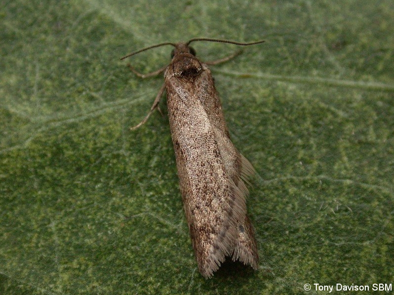
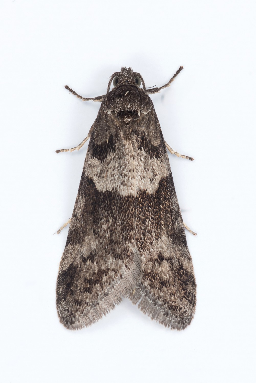
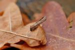
Image Gallery

Temporal Distribution Chart
Adults: (between 1965 - 2026)
Distribution Map for Tortricodes alternella
↳ 15 from 2026+
↳ 23 from 2020 - 2025
↳ 46 from Before 2020
If the Map Layers function fails, just refresh the page and it should be OK after. Use the +- zoom on the top left, or on a tablet, use two fingers to zoom. Remember, the last layer you ticked is the one which displays the popup information - they sit on top of each other - de-select then re-select, to see the popup values.
Bedrock Geology ** indirectly affects moth distribution by influencing the type of habitat and food plants available in an area. In turn, this may affect the types of moths that can thrive, or where they can most likely be found.
NBN Atlas UK Distribution for – Tortricodes alternella
⚠️ Please wait for the map to load fully – do not click the link shown.
Note – the NBN Atlas datasets are listed in the map below and vary in their currency (uptodateness) – however,
the map does give a general indication of the moth's distribution across the UK.
Monthly Records By Year:
Tortricodes alternella
( data includes both Larvae and Adult Stages )
Monthly Counts By Year:
Tortricodes alternella
( data is based on 'Adult' stage records only )
First/Last Recorded Dates: Tortricodes alternella
Adult-only & Anything [Larvae, Pupae, Adult, Mines]
Shading shows moth presence between dates
Click the colour discs below to Select/De-select as Required
Recordings By Year: Tortricodes alternella
( All data includes both Larvae and Adult Stages )
Annual Growth Rate (AGR): Tortricodes alternella
AGR: 3.22% | Total % Change: 100.7%
Hectad (10kmx10km) Coverage: Tortricodes alternella
( data includes both Larvae and Adult Stages )
Flight Periods – Indicative –vs– Recorded Data
Tortricodes alternella
Tortricodes alternella
Flight Period chart – the grey hatched area above, which can cross one or more months, pictorially represents the best guess we have for this moth's flight periods [month/s]. The coloured lines represent the actual months seen in flight, from site observation records received between 2020-2026.
Records Behind the Map and Charts - Tortricodes alternella – 84 records available
Listed by Year - descending - scroll across to see all table columns
| Site Name | Tetrad | Date | Count | Stage | Recorder | Source | RecordKey |
|---|---|---|---|---|---|---|---|
| Chaddesden Wood | SK33Z | 02/03/2026 | 3 | Adult | Roome, Martin | vc57_irecords_extract | iBRC50552873 |
| Glossop, Hague Street, Hay Meadow | SK09G | 25/02/2026 | 1 | Adult | Heintzen, Christian | vc57_irecords_extract | iBRC51122030 |
| bow wood | SK35D | 25/02/2026 | 30 | Adult | Ashton, Clive | vc57_irecords_extract | iBRC50366755 |
| Glossop, Gnat Hole Rough Fields | SK09L | 24/02/2026 | 1 | Adult | Heintzen, Christian | vc57_irecords_extract | iBRC51122025 |
| Markham Vale North tip , Derbyshire | SK47L | 24/02/2026 | 1 | Adult | Morris, Sid ( M.V. Trapping group ) | vc57_irecords_extract | iBRC50362966 |
| Nether Padley | SK27N | 22/02/2026 | 1 | Adult | Samuel P.C. | vc57_irecords_extract | iBRC50334228 |
| Froggatt Edge | SK27N | 22/02/2026 | 1 | Adult | Samuel P.C. | vc57_irecords_extract | iBRC50584463 |
| Froggat Edge | SK27N | 22/02/2026 | 1 | Adult | Samuel P.C. | vc57_irecords_extract | iBRC50729834 |
| Derbyshire Wild Life Trust Long Clough | SK09G | 21/02/2026 | 48 | Adult | Heintzen, Christian | vc57_irecords_extract | iBRC51122020 |
| Chaddesden Wood | SK33Z | 09/02/2026 | 4 | Adult | Roome, Martin | vc57_irecords_extract | iBRC50552720 |
| Longdendale, Wildboar Clough Woodland | SK09U | 08/02/2026 | 185 | Adult | Heintzen, Christian | vc57_irecords_extract | iBRC51122014 |
| Norton Lees, Sheffield | SK38L | 01/02/2026 | 1 | Adult | Mella, Pete | vc57_irecords_extract | iBRC49383497 |
| Chaddesden Wood | SK33Z | 30/01/2026 | 1 | Adult | Roome, Martin | vc57_irecords_extract | iBRC49578107 |
| Derbyshire Wild Life Trust Long Clough | SK09G | 19/01/2026 | 10 | Adult | Heintzen, Christian | vc57_irecords_extract | iBRC51122007 |
| Chaddesden Wood | SK33Z | 19/01/2026 | 3 | Adult | Roome, Martin | vc57_irecords_extract | iBRC49574262 |
| Derbyshire Wild Life Trust Long Clough | SK09G | 07/03/2025 | 1 | Adult | Heintzen, Christian | vc57_irecords_extract | iBRC40399452 |
| Glossop, Shawmoor Plantation | SK09G | 21/02/2025 | 13 | Adult | Heintzen, Christian | vc57_irecords_extract | iBRC40322235 |
| Derbyshire Wild Life Trust Long Clough | SK09G | 19/02/2025 | 20 | Adult | Heintzen, Christian | vc57_irecords_extract | iBRC40322228 |
| Derbyshire Wildlife Trust Long Clough Woodand | SK09G | 03/02/2025 | 10 | Adult | Heintzen, Christian | vc57_irecords_extract | iBRC40159332 |
| Froggatt, Hope Valley | SK27N | 20/02/2024 | 1 | Adult | Barnacle, Bryan | vc57_irecords_extract | iBRC38615388 |
| Markham Vale South Tip | SK47L | 19/02/2024 | 1 | Adult | Morris, Sid | vc57_irecords_extract | iBRC34938099 |
| Markham Vale Derbyshire | SK47L | 19/02/2024 | 1 | Adult | Morris, Sid | vc57_irecords_extract | iBRC41006634 |
| High Leas Farm, Riber | SK35D | 16/02/2024 | 1 | Adult | Thorpe, Steve | vc57_irecords_extract | iBRC34931258 |
| High Leas Farm, Riber | SK35D | 16/02/2024 | 2 | Adult | Thorpe, Steve | vc57_irecords_extract | iBRC34931263 |
| Birch Vale | SK08I | 15/02/2024 | 1 | Adult | Hewitt, Jane | vc57_irecords_extract | iBRC34933539 |
| Longdendale, Wildboar Clough | SK09U | 15/02/2024 | 8 | Adult | Heintzen, Christian | vc57_irecords_extract | iBRC36371428 |
| Derbyshire Wild Life Trust Long Clough | SK09G | 10/02/2024 | 2 | Adult | Heintzen, Christian | vc57_irecords_extract | iBRC36371423 |
| Melbourne | SK32X | 09/02/2024 | 1 | Adult | Davison, Tony | vc57_irecords_extract | iBRC34794930 |
| Norton Lees, Sheffield | SK38L | 03/02/2024 | 1 | Adult | Mella, Pete | vc57_irecords_extract | iBRC34727780 |
| Derbyshire Wild Life Trust Long Clough | SK09G | 02/02/2024 | 3 | Adult | Heintzen, Christian | vc57_irecords_extract | iBRC36371416 |
| Glossop, Shire Hill, south | SK09M | 01/02/2024 | 6 | Adult | Heintzen, Christian | vc57_irecords_extract | iBRC36371409 |
| Longdendale, Wildboar Clough | SK09U | 28/01/2024 | 1 | Adult | Heintzen, Christian | vc57_irecords_extract | iBRC36371406 |
| Glossop, Shire Hill, south | SK09M | 16/02/2023 | 15 | Adult | Heintzen, Christian | vc57_irecords_extract | iBRC36335661 |
| Derbyshire Wild Life Trust Long Clough | SK09G | 13/02/2023 | 1 | Adult | Heintzen, Christian | vc57_irecords_extract | iBRC36335657 |
| Darwin Forest | SK26X | 09/02/2022 | 1 | Adult | Evans, Dave | vc57_irecords_extract | iBRC39218244 |
| Norton Lees | SK38L | 23/02/2021 | 1 | Adult | Mella, Pete | vc57_irecords_extract | iBRC50547207 |
| Norton Lees | SK38L | 21/02/2021 | 1 | Adult | Mella, Pete | vc57_irecords_extract | iBRC50547124 |
| Findern, Derbyshire, DEAZ | SK33A | 20/02/2021 | 1 | Adult | Hallam, Brian and Jean | vc57_irecords_extract | iBRC35164465 |
| Clough Wood,Darley Dale | SK26K | 28/02/2012 | 5 | Adult | A. Butler | vc57_danes_bc_data | LC000334001CP7PB |
| Glebe Rise,Littleover,Derby | SK33H | 28/02/2012 | 1 | Adult | N.J. Ward | vc57_danes_bc_data | LC000334001CP7PE |
| Calke Park,Ticknall | SK32R | 24/02/2012 | 1 | Adult | VC57 Derbyshire Recorder | vc57_danes_bc_data | LC000334001CP7P8 |
| The Hollies,Station Rd,Darley Dale | SK26R | 23/02/2012 | 3 | Adult | Roddis, Simon | vc57_danes_bc_data | LC000334001CP7P5 |
| Nutwood NR, Darley Abbey, Derby | SK33P | 23/02/2012 | 1 | Adult | VC57 Derbyshire Recorder | vc57_danes_bc_data | LC000334001CP7P7 |
| School Close,Parkway Gardens,Darley Dale | SK26R | 21/02/2012 | 1 | Adult | A. Butler | vc57_danes_bc_data | LC000334001CP7P1 |
| Backgarden Marehay | SK34Z | 21/02/2012 | 1 | Adult | Thorpe, Steve | vc57_irecords_extract | iBRC33509905 |
| Bamford St,Ripley | SK34Z | 21/02/2012 | 1 | Adult | Thorpe, Steve | vc57_danes_bc_data | LC000334001CP7P2 |
| School Close,Parkway Gardens,Darley Dale | SK26R | 25/01/2012 | 1 | Adult | A. Butler | vc57_danes_bc_data | LC000334001CP7OY |
| Clough Wood,Darley Dale | SK26K | 23/03/2011 | 1 | Adult | A. Butler | vc57_danes_bc_data | LC000334001COXL3 |
| Clough Wood,Darley Dale | SK26K | 19/03/2011 | 1 | Adult | A. Butler | vc57_danes_bc_data | LC000334001CP6RO |
| School Close,Parkway Gardens,Darley Dale | SK26R | 27/02/2011 | 1 | Adult | A. Butler | vc57_danes_bc_data | LC000334001CP6RE |
| School Close,Parkway Gardens,Darley Dale | SK26R | 23/02/2011 | 1 | Adult | A. Butler | vc57_danes_bc_data | LC000334001CP6R9 |
| School Close,Parkway Gardens,Darley Dale | SK26R | 10/02/2011 | 2 | Adult | A. Butler | vc57_danes_bc_data | LC000334001CP6R6 |
| Drakelow NR (Minton's Lagoon), Burton on Trent | SK22F | 22/08/2009 | 3 | Adult | M.J. Williams | vc57_danes_bc_data | LC000334001CP50T |
| Calke Park,Ticknall | SK32L | 16/03/2009 | 2 | Adult | Finch, Graham Leonard | vc57_danes_bc_data | LC000334001COZZV |
| Calke Park,Ticknall | SK32L | 06/03/2009 | 47 | Adult | Finch, Graham Leonard | vc57_danes_bc_data | LC000334001COZZQ |
| Calke Park Estate bottom of Fishermans carpark | SK32R | 06/03/2008 | 6 | Adult | Finch, Graham Leonard | vc57_irecords_extract | iBRC35105614 |
| Calke Park,Ticknall | SK32R | 06/03/2008 | 6 | Adult | Finch, Graham Leonard | vc57_danes_bc_data | LC000334001COZWD |
| Calke Park Ridge from Fisherman's Car Park | SK32R | 26/03/2007 | 1 | Adult | Finch, Graham Leonard | vc57_irecords_extract | iBRC35105778 |
| Calke Park,Ticknall | SK32R | 26/03/2007 | 1 | Adult | Finch, Graham Leonard | vc57_danes_bc_data | LC000334001CP3QK |
| Calke Park | SK32L | 12/03/2007 | 4 | Adult | Finch, Graham Leonard | vc57_irecords_extract | iBRC35105453 |
| Calke Park,Ticknall | SK32L | 12/03/2007 | 4 | Adult | G.L. Finch;K. Tailby;M.A. Finch | vc57_danes_bc_data | LC000334001CP3QF |
| Foremark Res (Boat Yard edge), Ticknall | SK32G | 15/03/2004 | 5 | Adult | BUDWORTH, Mr D., WILLIAMS, Mr M.J., WILLIAMS, Mrs | vc57_danes_bc_data | LC000334001COVJT |
| FOREMARK RESERVOIR | SK32H | 15/03/2004 | 30 | Adult | Davison, Tony | vc57_irecords_extract | iBRC33454928 |
| Foremark Resr (Orchid meadow edge), Ticknall | SK32H | 15/03/2004 | 2 | Adult | BUDWORTH, Mr D., WILLIAMS, Mr M.J., WILLIAMS, Mrs | vc57_danes_bc_data | LC000334001COZPZ |
| Foremark Resr (Spur's Bottom wood), Ticknall | SK32H | 15/03/2004 | 9 | Adult | BUDWORTH, Mr D., WILLIAMS, Mr M.J., WILLIAMS, Mrs | vc57_danes_bc_data | LC000334001COZQ0 |
| Foremark Resr (Spur's Bottom wood), Ticknall | SK32H | 15/03/2004 | 11 | Adult | BUDWORTH, Mr D., WILLIAMS, Mr M.J., WILLIAMS, Mrs | vc57_danes_bc_data | LC000334001COZQ4 |
| Lings Close,Ilkeston | SK44S | 05/03/2004 | 1 | Adult | T. Duro | vc57_danes_bc_data | LC000334001COVJR |
| Calke Park (Poker's Leys), Ticknall | SK32L | 15/03/1998 | 1 | Adult | VC57 Derbyshire Recorder | vc57_danes_bc_data | LC000334001COVEN |
| Pokers Leys,Calke Park,Ticknall | SK32L | 20/02/1998 | 30 | Adult | VC57 Derbyshire Recorder | vc57_danes_bc_data | LC000334001COVEL |
| Calke Park (Poker's Leys), Ticknall | SK32L | 13/02/1998 | 5 | Adult | VC57 Derbyshire Recorder | vc57_danes_bc_data | LC000334001COVEJ |
| Calke Park (Betty's Pool),Ticknall | SK32R | 10/08/1997 | 2 | Adult | VC57 Derbyshire Recorder | vc57_danes_bc_data | LC000334001COZMZ |
| Shipley Wood, Shipley Park, Ilkeston | SK44L | 17/03/1997 | 3 | Adult | VC57 Derbyshire Recorder | vc57_danes_bc_data | LC000334001COQX0 |
| Calke Park,Ticknall | SK32R | 09/03/1997 | 1 | Adult | VC57 Derbyshire Recorder | vc57_danes_bc_data | LC000334001COQWU |
| Calke Park (Poker's Leys), Ticknall | SK32L | 27/02/1997 | 1 | Adult | VC57 Derbyshire Recorder | vc57_danes_bc_data | LC000334001COQWS |
| Shipley Wood, Shipley Park, Ilkeston | SK44M | 09/04/1996 | 1 | Adult | VC57 Derbyshire Recorder | vc57_danes_bc_data | LC000334001COVBX |
| The Field,Shipley,Ilkeston | SK44M | 09/04/1996 | 1 | Adult | T. Duro | vc57_danes_bc_data | LC000334001CP197 |
| Clough Wood (nr gate entrance), Darley Dale | SK26K | 23/03/1996 | 30 | Adult | VC57 Derbyshire Recorder | vc57_danes_bc_data | LC000334001CP193 |
| Carvers Rocks, Hartshorne, Swadlincote | SK32G | 02/04/1995 | 1 | Adult | VC57 Derbyshire Recorder | vc57_danes_bc_data | LC000334001CP15K |
| Carvers Rocks NR, Hartshorne, Swadlincote (site not precise) | SK32G | 07/03/1981 | 1 | Adult | YOUNG, Mr D.A., HARRISON, Mr F., BEAUMONT, Mr H.E. | vc57_danes_bc_data | LC000334001COQCH |
| Upper Booth, Edale | SK08X | 08/02/1981 | 1 | Adult | VC57 Derbyshire Recorder | vc57_danes_bc_data | LC000334001COQCG |
| Hardwick Wood, Wingerworth | SK36S | 19/03/1972 | 1 | Adult | VC57 Derbyshire Recorder | vc57_danes_bc_data | LC000334001CP9UN |
| Hardwick Wood, Wingerworth | SK36S | 16/03/1972 | 1 | Adult | VC57 Derbyshire Recorder | vc57_danes_bc_data | LC000334001CP9UM |
| Linacre Woods, Chesterfield | SK37G | 27/09/1969 | 1 | Adult | VC57 Derbyshire Recorder | vc57_danes_bc_data | LC000334001COQHQ |
| Lightwood Lane, Moss Valley | SK38R | 08/03/1965 | 1 | Adult | VC57 Derbyshire Recorder | vc57_danes_bc_data | LC000334001CP0J4 |