
 Larval Case: C2 – Photo or specimen of larval case/plant required –
  – click for General Verification Guidelines | – click for Specific Verification Guidelines
  – Generally Common / Widespread
  – Leaf-miner
  – Day-flying
Confusion Species: C.alcyonipennella and C.deauratella
Mine Period Additional: None.
Mine ID Difficulty:
Mine Type/s: Not Recorded
Mine Feeding Method/s: Case
Mine Comment: The larva feed on the seeds of White Clover forming a case from the floret and feeding until they are fully developed by early August. They hibernate on the ground in their cases over the winter re-appearing in the spring with the overall mining/feeding activity lasting until May.
Blue-coded] moths is not displayed/updated in this tab. However, all verified records for this moth are listed in the RECORDS tab below. 

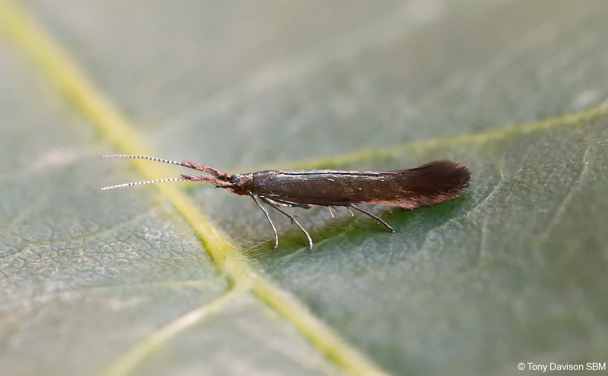
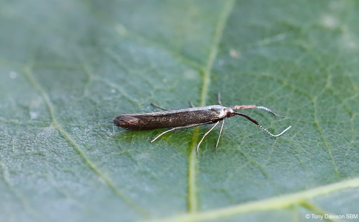
Image Gallery

Temporal Distribution Chart
Adults: (between 1994 - 2026)
Distribution Map for Coleophora mayrella
↳ 3 from 2026+
↳ 12 from 2020 - 2025
↳ 13 from Before 2020
If the Map Layers function fails, just refresh the page and it should be OK after. Use the +- zoom on the top left, or on a tablet, use two fingers to zoom. Remember, the last layer you ticked is the one which displays the popup information - they sit on top of each other - de-select then re-select, to see the popup values.
Bedrock Geology ** indirectly affects moth distribution by influencing the type of habitat and food plants available in an area. In turn, this may affect the types of moths that can thrive, or where they can most likely be found.
NBN Atlas UK Distribution for – Coleophora mayrella
⚠️ Please wait for the map to load fully – do not click the link shown.
Note – the NBN Atlas datasets are listed in the map below and vary in their currency (uptodateness) – however,
the map does give a general indication of the moth's distribution across the UK.
Monthly Records By Year:
Coleophora mayrella
( data includes both Larvae and Adult Stages )
Monthly Counts By Year:
Coleophora mayrella
( data is based on 'Adult' stage records only )
First/Last Recorded Dates: Coleophora mayrella
Adult-only & Anything [Larvae, Pupae, Adult, Mines]
Shading shows moth presence between dates
Click the colour discs below to Select/De-select as Required
Recordings By Year: Coleophora mayrella
( All data includes both Larvae and Adult Stages )
Annual Growth Rate (AGR): Coleophora mayrella
AGR: 0% | Total % Change: 0%
Hectad (10kmx10km) Coverage: Coleophora mayrella
( data includes both Larvae and Adult Stages )
Flight Periods – Indicative –vs– Recorded Data
Coleophora mayrella
Coleophora mayrella
Flight Period chart – the grey hatched area above, which can cross one or more months, pictorially represents the best guess we have for this moth's flight periods [month/s]. The coloured lines represent the actual months seen in flight, from site observation records received between 2020-2026.
Mine Periods – Indicative –vs– Recorded Data
Coleophora mayrella
Coleophora mayrella
( data includes both Larvae and Adult Stages )
Mine Period chart – the grey hatched area above, which can cross one or more months, pictorially represents the best guess we have for this moth's mine periods [month/s]. The coloured lines represent the actual months seen mining, from site observation records received between 2020-2026.
Records Behind the Map and Charts - Coleophora mayrella – 28 records available
Listed by Year - descending - scroll across to see all table columns
| Site Name | Tetrad | Date | Count | Stage | Recorder | Source | RecordKey |
|---|---|---|---|---|---|---|---|
| Sandiacre, Derbyshire | SK43S | 25/06/2026 | 1 | adult | Buxton, Paul | vc57_irecords_extract | iBRC54069734 |
| Norton Lees, Sheffield | SK38L | 23/06/2026 | 1 | adult | Mella, Pete | vc57_irecords_extract | iBRC53959837 |
| Sandiacre, Derbyshire | SK43S | 23/06/2026 | 1 | adult | Buxton, Paul | vc57_irecords_extract | iBRC53993683 |
| Allestree, Derby | SK33P | 26/06/2025 | 2 | Adult | Plant, Stephen | vc57_irecords_extract | iBRC48476942 |
| Allestree, Derby | SK33P | 29/06/2024 | 1 | Adult | Plant, Stephen | vc57_irecords_extract | iBRC48476867 |
| Buxton SK, UK | SK07S | 30/06/2022 | 1 | Adult | Orridge, Steve | vc57_irecords_extract | iBRC28635332 |
| Birch Vale | SK08I | 21/06/2022 | 2 | Adult | Hewitt, Jane | vc57_irecords_extract | iBRC34084004 |
| Birch Vale | SK08I | 17/06/2022 | 1 | Adult | Hewitt, Jane | vc57_irecords_extract | iBRC34083932 |
| Hathersage, Derbyshire, UK | SK28F | 17/06/2022 | 1 | Adult | Miles, Claire | vc57_irecords_extract | iBRC28792621 |
| Hathersage, Derbyshire, UK | SK28F | 11/06/2022 | 1 | Adult | Miles, Claire | vc57_irecords_extract | iBRC28685468 |
| Hathersage, Derbyshire, UK | SK28F | 26/06/2021 | 1 | Adult | Miles, Claire | vc57_irecords_extract | iBRC29594910 |
| Hathersage, Derbyshire, UK | SK28F | 19/06/2021 | 1 | Adult | Miles, Claire | vc57_irecords_extract | iBRC29593969 |
| Shirland - Hallfieldgate Lane | SK35Z | 16/06/2021 | 1 | Adult | Mahadevan, Nikki | vc57_irecords_extract | iBRC34957084 |
| Hathersage, Derbyshire, UK | SK28F | 09/06/2021 | 2 | Adult | Miles, Claire | vc57_irecords_extract | iBRC29584309 |
| Hathersage, Derbyshire, UK | SK28F | 09/06/2021 | 2 | Adult | Miles, Claire | vc57_irecords_extract | iBRC29584425 |
| Hoe Grange Quarry | SK25I | 16/06/2018 | 1 | Adult | Steve Orridge & Ray Walker | vc57_irecords_extract | iBRC49168478 |
| Main Street, Kings Newton | SK32Y | 18/07/2016 | 2 | Adult | Soar, Will | vc57_irecords_extract | iBRC34060090 |
| Jim Mart Nature Reserve | SK36S | 15/07/2015 | 1 | Adult | Mahadevan, Nikki | vc57_irecords_extract | iBRC34907878 |
| Spinney Hill,Melbourne | SK32X | 28/07/2011 | 1 | Adult | Davison, Tony | vc57_danes_bc_data | LC000334001COXU8 |
| Melbourne, Derbyshire | SK32X | 27/07/2011 | 1 | Adult | Davison, Tony | vc57_irecords_extract | iBRC33086195 |
| Main Street, Kings Newton | SK32Y | 27/06/2005 | 1 | Adult | Soar, Will | vc57_irecords_extract | iBRC34677039 |
| Main St,Kings Newton,Melbourne | SK32Y | 27/06/2005 | 1 | Adult | Soar, Will | vc57_danes_bc_data | LC000334001CORIO |
| Ticknall Limeyards, Calke Park | SK32R | 17/06/2005 | 1 | Adult | Soar, Will | vc57_irecords_extract | iBRC34677038 |
| Ticknall Limeyards,Ticknall | SK32R | 17/06/2005 | 1 | Adult | Dave Budworth;A. Davison;N.J. Ward;W. Soar | vc57_danes_bc_data | LC000334001CP2IB |
| Crich Chase, Ambergate (site not precise) | SK35L | 27/06/1996 | 1 | Adult | VC57 Derbyshire Recorder | vc57_danes_bc_data | LC000334001CP19D |
| Acton Rd Ind Est, Long Eaton | SK43W | 19/07/1995 | 1 | Adult | VC57 Derbyshire Recorder | vc57_danes_bc_data | LC000334001COS49 |
| Acton Rd Ind Est, Long Eaton | SK43W | 28/06/1995 | 1 | Adult | VC57 Derbyshire Recorder | vc57_danes_bc_data | LC000334001CP167 |
| Deerlands Rd, Ashgate, Chesterfield | SK37K | 01/07/1994 | 1 | Adult | VC57 Derbyshire Recorder | vc57_danes_bc_data | LC000334001CP136 |