
 – click for General Verification Guidelines | – click for Specific Verification Guidelines
  – Generally Common / Widespread
  – Day-flying
Confusion Species: White-line Pollen-moth
Blue-coded] moths is not displayed/updated in this tab. However, all verified records for this moth are listed in the RECORDS tab below. 
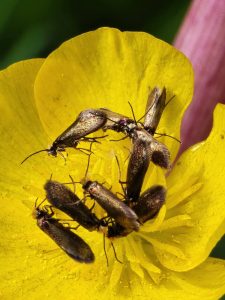


Image Gallery

Temporal Distribution Chart
Adults: (between 2004 - 2026)
Distribution Map for Micropterix calthella
↳ 25 from 2026+
↳ 29 from 2020 - 2025
↳ 8 from Before 2020
If the Map Layers function fails, just refresh the page and it should be OK after. Use the +- zoom on the top left, or on a tablet, use two fingers to zoom. Remember, the last layer you ticked is the one which displays the popup information - they sit on top of each other - de-select then re-select, to see the popup values.
Bedrock Geology ** indirectly affects moth distribution by influencing the type of habitat and food plants available in an area. In turn, this may affect the types of moths that can thrive, or where they can most likely be found.
NBN Atlas UK Distribution for – Micropterix calthella
⚠️ Please wait for the map to load fully – do not click the link shown.
Note – the NBN Atlas datasets are listed in the map below and vary in their currency (uptodateness) – however,
the map does give a general indication of the moth's distribution across the UK.
Monthly Records By Year:
Micropterix calthella
( data includes both Larvae and Adult Stages )
Monthly Counts By Year:
Micropterix calthella
( data is based on 'Adult' stage records only )
First/Last Recorded Dates: Micropterix calthella
Adult-only & Anything [Larvae, Pupae, Adult, Mines]
Shading shows moth presence between dates
Click the colour discs below to Select/De-select as Required
Recordings By Year: Micropterix calthella
( All data includes both Larvae and Adult Stages )
Annual Growth Rate (AGR): Micropterix calthella
AGR: -4.11% | Total % Change: -60.3%
Hectad (10kmx10km) Coverage: Micropterix calthella
( data includes both Larvae and Adult Stages )
Flight Periods – Indicative –vs– Recorded Data
Micropterix calthella
Micropterix calthella
Flight Period chart – the grey hatched area above, which can cross one or more months, pictorially represents the best guess we have for this moth's flight periods [month/s]. The coloured lines represent the actual months seen in flight, from site observation records received between 2020-2026.
Records Behind the Map and Charts - Micropterix calthella – 62 records available
Listed by Year - descending - scroll across to see all table columns
| Site Name | Tetrad | Date | Count | Stage | Recorder | Source | RecordKey |
|---|---|---|---|---|---|---|---|
| Darwin Forest | SK36C | 22/06/2026 | 3 | adult | Evans, Dave | vc57_irecords_extract | iBRC53898141 |
| Darwin Forest | SK36C | 21/06/2026 | 2 | adult | Evans, Dave | vc57_irecords_extract | iBRC53846450 |
| Buxton, Cunning Dale | SK07R | 20/06/2026 | 1 | adult | Orridge, Steve | vc57_irecords_extract | iBRC53864080 |
| Darwin Forest | SK26X | 20/06/2026 | 2 | adult | Evans, Dave | vc57_irecords_extract | iBRC53812599 |
| Darwin Forest | SK36C | 20/06/2026 | 2 | adult | Evans, Dave | vc57_irecords_extract | iBRC53812093 |
| Darwin Forest | SK36C | 19/06/2026 | 3 | adult | Evans, Dave | vc57_irecords_extract | iBRC53789668 |
| Darwin Forest | SK36C | 18/06/2026 | 3 | adult | Evans, Dave | vc57_irecords_extract | iBRC53751538 |
| Belper | SK34N | 29/05/2026 | 7 | adult | Evans, Dave | vc57_irecords_extract | iBRC52771040 |
| Cromford Moor | SK25X | 23/05/2026 | 200 | adult | Ashton, Clive | vc57_irecords_extract | iBRC52546972 |
| rose end meadows | SK25Y | 21/05/2026 | 3 | adult | Ashton, Clive | vc57_irecords_extract | iBRC52472765 |
| rose end meadows | SK25Y | 20/05/2026 | 50 | adult | Ashton, Clive | vc57_irecords_extract | iBRC52430378 |
| Heage | SK34U | 09/05/2026 | 1 | adult | Evans, Dave | vc57_irecords_extract | iBRC52099672 |
| Heage | SK35Q | 09/05/2026 | 1 | adult | Evans, Dave | vc57_irecords_extract | iBRC52099921 |
| Cromford Moor | SK25X | 08/05/2026 | 5 | adult | Ashton, Clive | vc57_irecords_extract | iBRC52085213 |
| Heage | SK34U | 08/05/2026 | 1 | adult | Evans, Dave | vc57_irecords_extract | iBRC52072559 |
| Belper | SK34P | 07/05/2026 | 1 | adult | Evans, Dave | vc57_irecords_extract | iBRC52040285 |
| DWT Wyver Lane | SK34P | 06/05/2026 | 1 | adult | Evans, Dave | vc57_irecords_extract | iBRC52026435 |
| DWT Wyver Lane | SK34P | 06/05/2026 | 3 | adult | Evans, Dave | vc57_irecords_extract | iBRC52027118 |
| Belper | SK34P | 05/05/2026 | 3 | adult | Evans, Dave | vc57_irecords_extract | iBRC51995505 |
| Heage | SK35Q | 01/05/2026 | 1 | adult | Evans, Dave | vc57_irecords_extract | iBRC51891003 |
| DWT Wyver Lane | SK34P | 30/04/2026 | 1 | adult | Evans, Dave | vc57_irecords_extract | iBRC51833253 |
| DWT Wyver Lane | SK34P | 29/04/2026 | 1 | adult | Evans, Dave | vc57_irecords_extract | iBRC51811928 |
| DWT Wyver Lane | SK34P | 29/04/2026 | 1 | adult | Evans, Dave | vc57_irecords_extract | iBRC51812429 |
| Heage | SK35Q | 25/04/2026 | 1 | adult | Evans, Dave | vc57_irecords_extract | iBRC51689694 |
| rose end meadows | SK25Y | 20/04/2026 | 1 | adult | Ashton, Clive | vc57_irecords_extract | iBRC51590569 |
| Serpentine Woods (north), Buxton | SK07L | 02/07/2025 | 1 | Adult | Mortin, Jon | vc57_irecords_extract | iBRC43006560 |
| Millfields ,Carsington | SK25K | 24/05/2025 | 5 | Adult | Ashton, Clive | vc57_irecords_extract | iBRC41789511 |
| Cunning Dale | SK07R | 18/05/2025 | 1 | Adult | Victoria J. Burton | vc57_irecords_extract | iBRC41705008 |
| Cunningdale, Buxton | SK07R | 18/05/2025 | 20 | Adult | Taylor, Sue | vc57_irecords_extract | iBRC42060855 |
| Deep Dale Sterndale | SK07V | 18/05/2025 | 1 | Adult | Greenland, Martin | vc57_irecords_extract | iBRC50360585 |
| Deep Dale Sterndale | SK07V | 18/05/2025 | 1 | Adult | Greenland, Martin | vc57_irecords_extract | iBRC50360588 |
| Monsal Dale | SK17Q | 06/05/2025 | 1 | Adult | White, Ian M | vc57_irecords_extract | iBRC41614154 |
| Goosehill Hall (SK) | SK18L | 11/06/2024 | 1 | Adult | Christopher Blakey | vc57_irecords_extract | iBRC36418524 |
| Derbyshire, UK | SK27Y | 19/05/2024 | 1 | Adult | Trevor Marshall | vc57_irecords_extract | iBRC36145441 |
| Cunningdale SAC | SK07R | 18/05/2024 | 1 | Adult | Mortin, Jon | vc57_irecords_extract | iBRC35976775 |
| Jim Mart Nature Reserve | SK36S | 09/05/2024 | 20 | Adult | Mahadevan, Nikki | vc57_irecords_extract | iBRC40509069 |
| Miller's Dale | SK17L | 05/05/2024 | 1 | Adult | Patmore, Stephen | vc57_irecords_extract | iBRC39708257 |
| Grinlow Woods, Derbyshire, UK | SK07L | 25/05/2023 | 1 | Adult | Mortin, Jon | vc57_irecords_extract | iBRC30540633 |
| Derbyshire, UK | SK37D | 21/05/2023 | 1 | Adult | Trevor Marshall | vc57_irecords_extract | iBRC30462843 |
| Jim Mart Nature Reserve | SK36S | 20/05/2023 | 1 | Adult | Mahadevan, Nikki | vc57_irecords_extract | iBRC34929899 |
| Grinlow Woods, Derbyshire, UK | SK07L | 01/06/2022 | 1 | Adult | Mortin, Jon | vc57_irecords_extract | iBRC25593310 |
| Trowell Marsh LNR | SK43U | 23/05/2022 | 1 | Adult | Bryce, Marion | vc57_irecords_extract | iBRC25496436 |
| Lathkilldale, Monyash | SK16N | 17/05/2022 | 100 | Adult | Bryce, Marion | vc57_irecords_extract | iBRC25493007 |
| Derbyshire, England, United Kingdom | SK07K | 26/06/2021 | 1 | Adult | Orridge, Steve | vc57_irecords_extract | iBRC22847211 |
| FerneyDale | SK07Q | 26/06/2021 | 1 | Adult | Orridge, Steve | vc57_irecords_extract | iBRC35092369 |
| Ferneydale | SK07Q | 21/06/2021 | 1 | Adult | Mortin, Jon | vc57_irecords_extract | iBRC22749362 |
| Grin Low | SK07K | 13/06/2021 | 7 | Adult | Wakefield, Rowan | vc57_irecords_extract | iBRC43076652 |
| Haddon Park | SK26I | 05/06/2021 | 4 | Adult | Hewitt, Jane | vc57_irecords_extract | iBRC34472739 |
| Jim Mart Nature Reserve | SK36S | 22/05/2021 | 1 | Adult | Mahadevan, Nikki | vc57_irecords_extract | iBRC34919365 |
| Jim Mart Nature Reserve | SK36S | 13/05/2021 | 1 | Adult | Mahadevan, Nikki | vc57_irecords_extract | iBRC34919363 |
| Waterswallows Quarry | SK07X | 17/07/2020 | 1 | Adult | Marriott, Antony | vc57_irecords_extract | iBRC15268950 |
| Jim Mart Nature Reserve | SK36S | 18/05/2020 | 1 | Adult | Mahadevan, Nikki | vc57_irecords_extract | iBRC34919195 |
| Jim Mart Nature Reserve | SK36S | 14/05/2020 | 1 | Adult | Mahadevan, Nikki | vc57_irecords_extract | iBRC34919193 |
| Mellor | SJ98Y | 09/05/2020 | 50 | Adult | BISSITT, ANDREW | vc57_irecords_extract | iBRC13389864 |
| Etherow CP | SJ99Q | 20/05/2019 | 40 | Adult | Higginson-Tranter, Dave | vc57_irecords_extract | iBRC10187556 |
| ROMAN LAKES | SJ98T | 16/05/2019 | 100 | Adult | BISSITT, ANDREW | vc57_irecords_extract | iBRC10225180 |
| Coombs Dale | SK27H | 07/06/2018 | 5 | Adult | Soar, Will | vc57_irecords_extract | iBRC34059698 |
| Etherow CP | SJ99Q | 21/05/2018 | 1 | Adult | Marriott, Antony | vc57_irecords_extract | iBRC6812908 |
| Etherow CP | SJ99Q | 21/05/2018 | 1 | Adult | Higginson-Tranter, Dave | vc57_irecords_extract | iBRC8625768 |
| Jim Mart Nature Reserve | SK36S | 14/06/2016 | 1 | Adult | Mahadevan, Nikki | vc57_irecords_extract | iBRC34908860 |
| Carsington Water | SK25L | 29/05/2011 | 1 | Adult | Thorpe, Steve | vc57_irecords_extract | iBRC33512427 |
| Carsington Water | SK25L | 16/05/2004 | 30 | Adult | Soar, Will | vc57_irecords_extract | iBRC34678808 |