
 – click for Adult Macro Verification Guidelines
 – Significant Record / Rare / Vagrant
 – Migrant
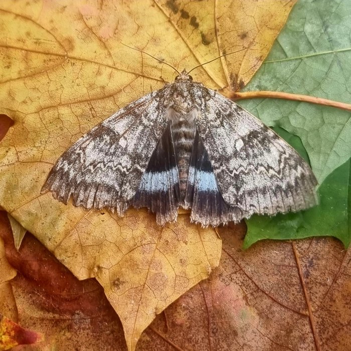
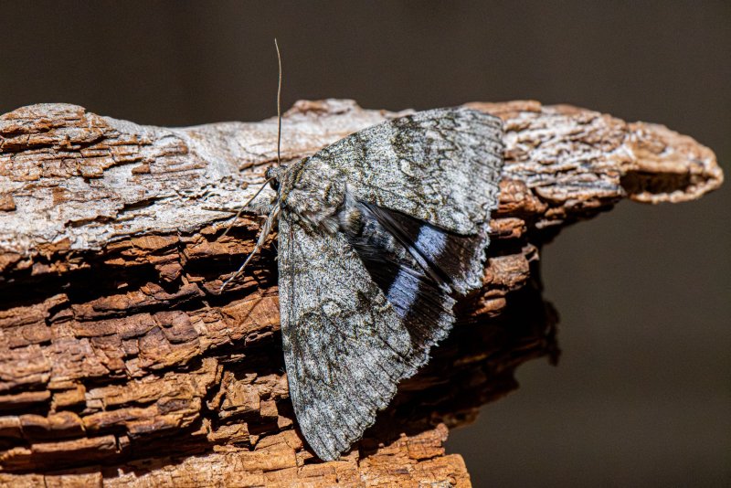
Forewing: 41-48mm


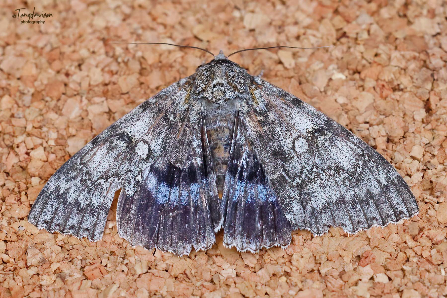
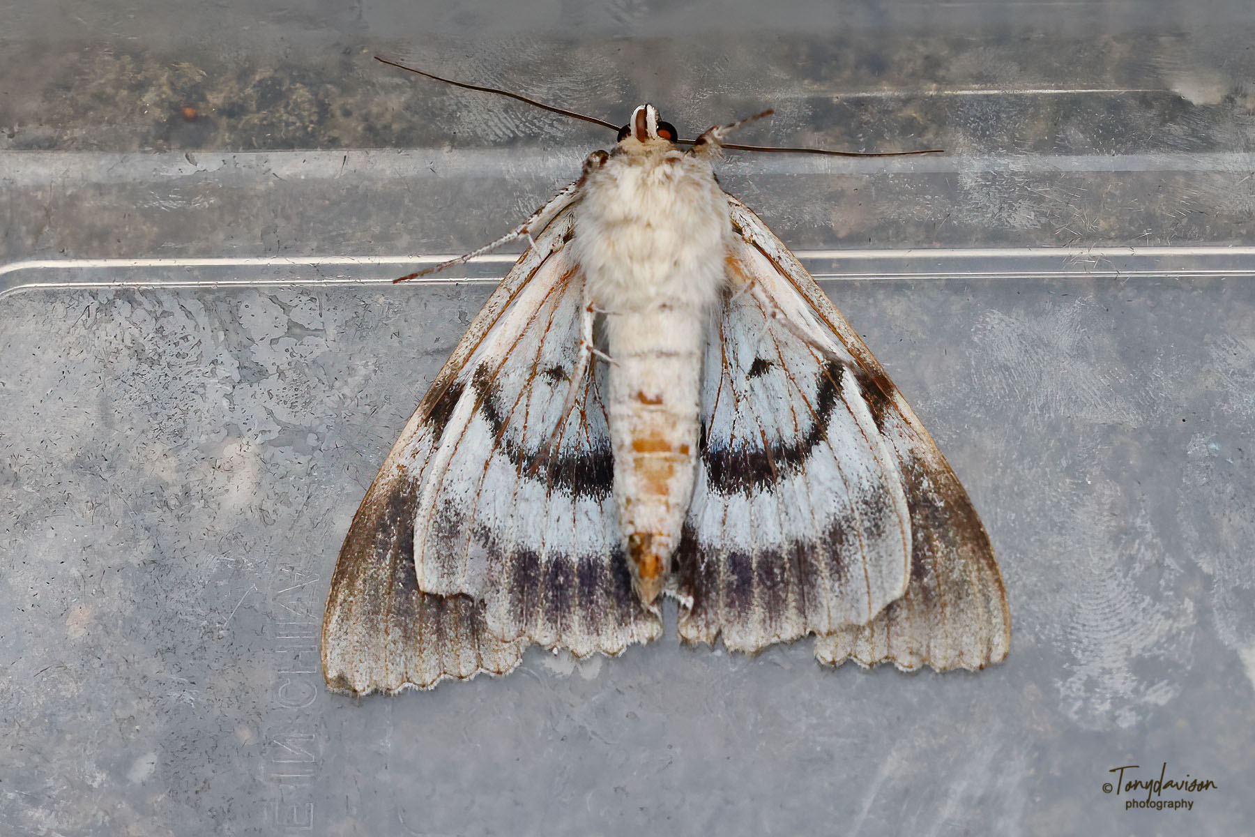
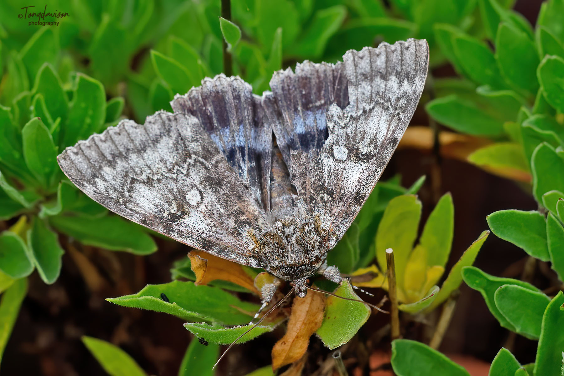
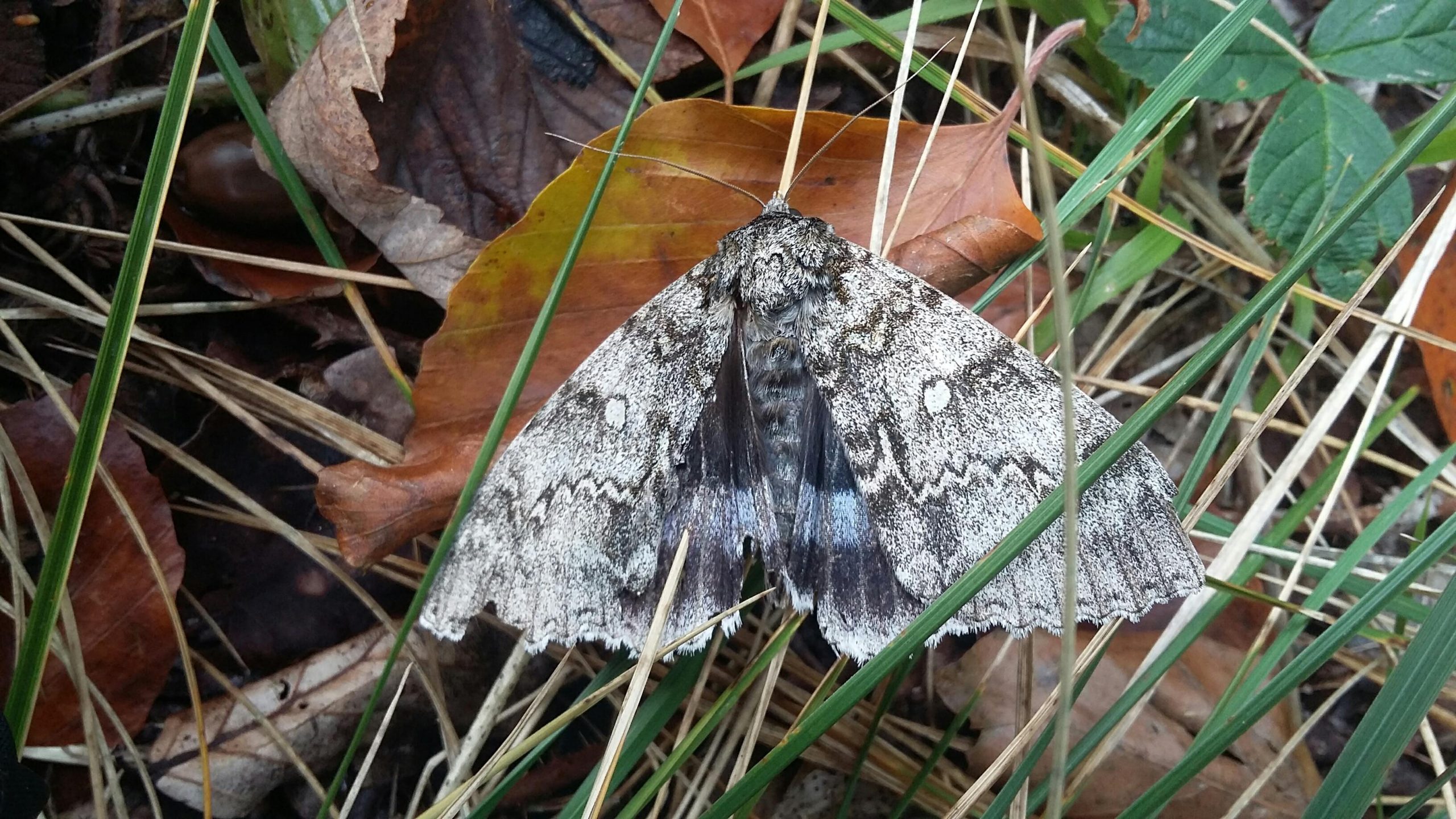
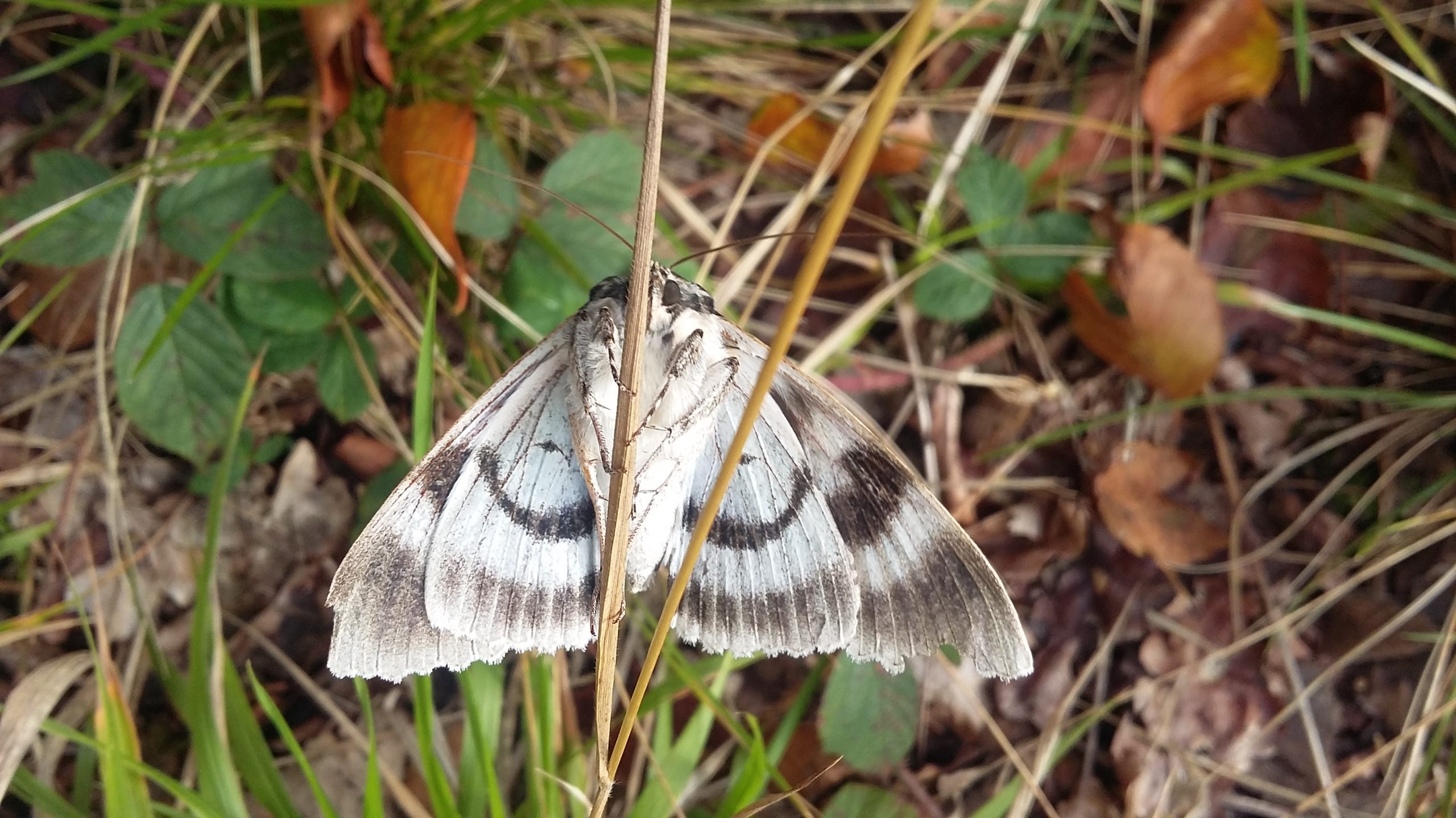
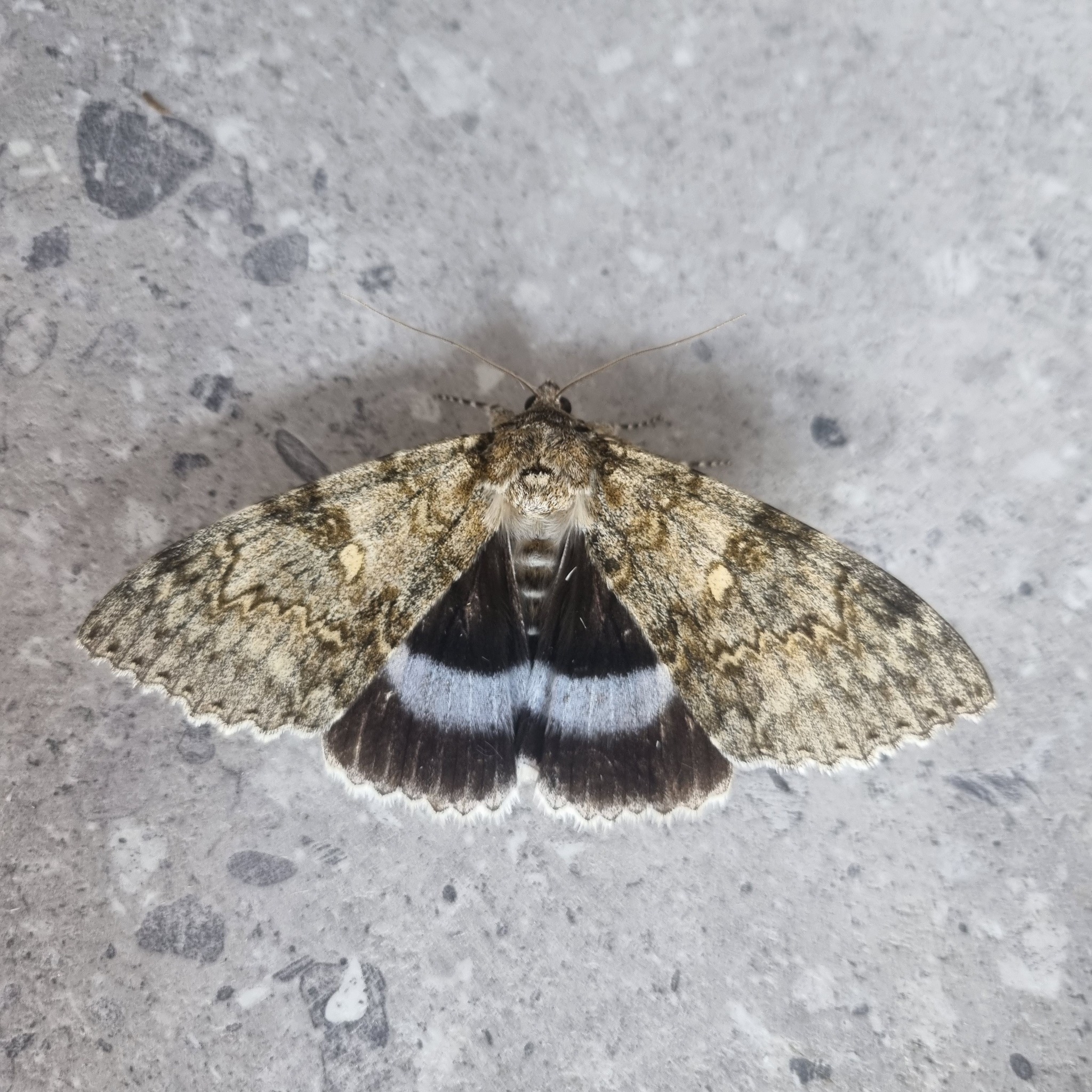
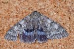
Image Gallery


Temporal Distribution Chart
Adults: (between 1966 - 2025)
Distribution Map for Catocala fraxini
↳ from 2026+
↳ 43 from 2020 - 2025
↳ 2 from Before 2020
If the Map Layers function fails, just refresh the page and it should be OK after. Use the +- zoom on the top left, or on a tablet, use two fingers to zoom. Remember, the last layer you ticked is the one which displays the popup information - they sit on top of each other - de-select then re-select, to see the popup values.
Bedrock Geology ** indirectly affects moth distribution by influencing the type of habitat and food plants available in an area. In turn, this may affect the types of moths that can thrive, or where they can most likely be found.
NBN Atlas UK Distribution for – Catocala fraxini
⚠️ Please wait for the map to load fully – do not click the link shown.
Note – the NBN Atlas datasets are listed in the map below and vary in their currency (uptodateness) – however,
the map does give a general indication of the moth's distribution across the UK.
Monthly Records By Year:
Catocala fraxini
( data includes both Larvae and Adult Stages )
Monthly Counts By Year:
Catocala fraxini
( data is based on 'Adult' stage records only )
First/Last Recorded Dates: Catocala fraxini
Adult-only & Anything [Larvae, Pupae, Adult, Mines]
Shading shows moth presence between dates
Click the colour discs below to Select/De-select as Required
Recordings By Year: Catocala fraxini
( All data includes both Larvae and Adult Stages )
Annual Growth Rate (AGR): Catocala fraxini
AGR: 0.74% | Total % Change: 10%
Hectad (10kmx10km) Coverage: Catocala fraxini
( data includes both Larvae and Adult Stages )
Flight Periods – Indicative –vs– Recorded Data
Catocala fraxini
Catocala fraxini
Flight Period chart – the grey hatched area above, which can cross one or more months, pictorially represents the best guess we have for this moth's flight periods [month/s]. The coloured lines represent the actual months seen in flight, from site observation records received between 2020-2026.
Records Behind the Map and Charts - Catocala fraxini – 45 records available
Listed by Year - descending - scroll across to see all table columns
| Site Name | Tetrad | Date | Count | Stage | Recorder | Source | RecordKey |
|---|---|---|---|---|---|---|---|
| Belper, Derbyshire | SK34N | 14/10/2025 | 1 | Adult | Newcombe, Dave | vc57_irecords_extract | iBRC50611074 |
| Midway, Derbys. | SK32A | 30/09/2025 | 1 | Adult | Williams, Michael | vc57_irecords_extract | iBRC45750305 |
| River Derwent nr Raynesway, Derby | SK33X | 24/09/2025 | 1 | Adult | Jonathon Gregson | vc57_irecords_extract | iBRC45625371 |
| Geo Siddall (Transport) Ltd, Bridge Garage, Matlock DEJY, UK | SK26Q | 19/09/2025 | 1 | Adult | Moores, Stephen | vc57_irecords_extract | iBRC45446747 |
| upper cromford garden | SK25Y | 18/09/2025 | 1 | Adult | Ashton, Clive | vc57_irecords_extract | iBRC45469503 |
| Findern, Derbyshire | SK33A | 18/09/2025 | 1 | Adult | Hallam, Brian | vc57_irecords_extract | iBRC45426215 |
| Darley Abbey | SK33P | 18/09/2025 | 1 | Adult | Chantelle Watson | vc57_irecords_extract | iBRC46124944 |
| North Wingfield, Derbyshire | SK46C | 12/09/2025 | 1 | Adult | Harper, Shane | vc57_irecords_extract | iBRC45320035 |
| mellor | SJ98Z | 09/09/2025 | 1 | Adult | Knass, David | vc57_irecords_extract | iBRC45286070 |
| Froggatt, Hope Valley | SK27N | 05/09/2025 | 1 | Adult | Barnacle, Bryan | vc57_irecords_extract | iBRC45143273 |
| Midway, Derbys. | SK32A | 04/09/2025 | 1 | Adult | Williams, Michael | vc57_irecords_extract | iBRC45130661 |
| Elvaston Castle, Derby DEEP, UK | SK43B | 02/09/2025 | 1 | Adult | Rod Whiteman | vc57_irecords_extract | iBRC45020146 |
| Mellor | SJ98Z | 30/08/2025 | 1 | Adult | Knass, David | vc57_irecords_extract | iBRC45025851 |
| Buxton | SK07R | 29/08/2025 | 1 | Adult | antdunn | vc57_irecords_extract | iBRC44979413 |
| Allestree, Derby | SK33P | 25/08/2025 | 1 | Adult | Plant, Stephen | vc57_irecords_extract | iBRC44841791 |
| Sandiacre Garden | SK43T | 24/08/2025 | 1 | Adult | Milnes, Emily | vc57_irecords_extract | iBRC51069163 |
| Cote Heath Allotments, Buxton | SK07R | 23/08/2025 | 1 | Adult | Bell, Steven | vc57_irecords_extract | iBRC44724507 |
| Sandiacre, Derbyshire | SK43S | 23/08/2025 | 3 | Adult | Buxton, Paul | vc57_irecords_extract | iBRC48259763 |
| Ilkeston, Derbyshire | SK44K | 22/08/2025 | 1 | Adult | Hobby, Brian | vc57_irecords_extract | iBRC45110339 |
| Belper, Derbyshire | SK34N | 15/08/2025 | 1 | Adult | Newcombe, Dave | vc57_irecords_extract | iBRC44661801 |
| Ashbourne, Derbyshire | SK24N | 22/09/2024 | 1 | Adult | Dutton, Michelle | vc57_irecords_extract | iBRC38592845 |
| Shirland - Hallfieldgate Lane | SK35Z | 20/09/2024 | 1 | Adult | Mahadevan, Nikki | vc57_irecords_extract | iBRC38605163 |
| Ilkeston, Derbyshire | SK44K | 20/09/2024 | 1 | Adult | Hobby, Brian | vc57_irecords_extract | iBRC38580276 |
| Sandiacre | SK43S | 09/08/2024 | 1 | Adult | Buxton, Paul | vc57_irecords_extract | iBRC37850671 |
| Chaddesden, Derby | SK33T | 08/08/2024 | 1 | Adult | Roome, Martin | vc57_irecords_extract | iBRC38681482 |
| Melbourne, Derbyshire | SK32X | 09/10/2023 | 1 | Adult | Davison, Tony | vc57_irecords_extract | iBRC33378000 |
| Havercroft Road | SK38L | 07/10/2023 | 1 | Adult | Tait, Malcolm | vc57_irecords_extract | iBRC36369306 |
| Woodland Ave | SK43R | 06/10/2023 | 1 | Adult | Thorpe, Steve | vc57_irecords_extract | iBRC33497452 |
| Woodland Ave | SK43R | 24/09/2023 | 1 | Adult | Thorpe, Steve | vc57_irecords_extract | iBRC33497382 |
| Shirland - Hallfieldgate Lane | SK35Z | 22/09/2023 | 1 | Adult | Mahadevan, Nikki | vc57_irecords_extract | iBRC34435639 |
| Southbourne Mews, Southbourne Road, Sheffield, SQN | SK38M | 20/09/2023 | 1 | Adult | Stewart, Stephen | vc57_irecords_extract | iBRC33205303 |
| Lower Cromford Garden | SK25Y | 17/09/2023 | 1 | Adult | Ashton, Clive | vc57_irecords_extract | iBRC34582355 |
| Froggatt, Hope Valley | SK27N | 17/09/2023 | 1 | Adult | Barnacle, Bryan | vc57_irecords_extract | iBRC38490646 |
| Millhouses, Sheffield | SK38M | 14/09/2023 | 1 | Adult | Chambers, Stephen | vc57_irecords_extract | iBRC33009888 |
| Repton Derbyshire | SK32D | 12/09/2023 | 1 | Adult | Burston, Tim | vc57_irecords_extract | iBRC32986828 |
| Findern Garden | SK33A | 08/09/2023 | 1 | Adult | Hallam, Brian | vc57_irecords_extract | iBRC34637294 |
| Kirk Hallam, Ilkeston | SK44K | 02/09/2023 | 1 | Adult | Hobby, Brian | vc57_irecords_extract | iBRC48691113 |
| Calke Park | SK32R | 02/10/2022 | 1 | Adult | Docker, Tom | vc57_irecords_extract | iBRC28253247 |
| Etches Park, Wilmorton, Derby | SK33S | 13/09/2021 | 1 | adult | VESSEY, Mr D. | Danes_2019-2021 | 21 |
| Briar Close, Newhall, Swadlincote | SK22V | 10/09/2021 | 1 | adult | PEACH, Mr K. | Danes_2019-2021 | 26 |
| Calke Explore, Calke Abbey | SK32L | 14/10/2020 | 1 | Adult | McGowan, Iain | vc57_irecords_extract | iBRC18047977 |
| Calke Park (nr Betty's Pool), Ticknall | SK32L | 14/10/2020 | 1 | adult | McGOWAN, Mr I.C. | Danes_2019-2021 | 278 |
| Somercotes, Alfreton | SK45G | 01/09/2020 | 1 | adult | HARDY, Mr D.R. | Danes_2019-2021 | 350 |
| Burton Rd, Findern, Derby | SK33A | 07/09/2012 | 1 | Adult | VC57 Derbyshire Recorder | vc57_danes_bc_data | LC000334001OLA1K |
| Ault Hucknall,Glapwell | SK46S | 25/09/1966 | 1 | Adult | VC57 Derbyshire Recorder | vc57_danes_bc_data | LC000334001OIHFX |