 Larval Case: C1 – Distinctive Species –
  – click for General Verification Guidelines | – click for Specific Verification Guidelines
  – Rare / Uncommon / Scarce
  – Leaf-miner
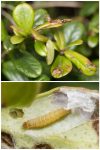
Mine Period Additional: The larvae start to form mines on the leaves of Cowberry producing obvious frass. The larvae then spin leaves together to feed on the cellular tissue of the soft parts of the leaves (Parenchyma).
Mine ID Difficulty: Not Recorded
Mine Type/s: Not Recorded
Mine Feeding Method/s: Not Recorded
Mine Comment: None.


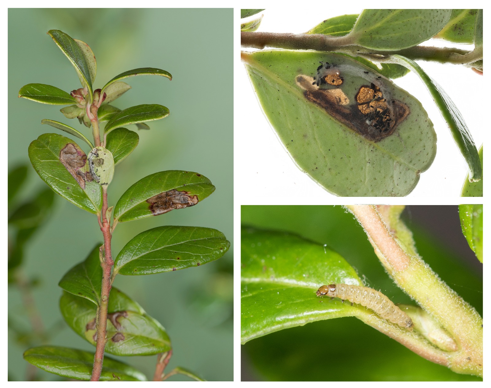
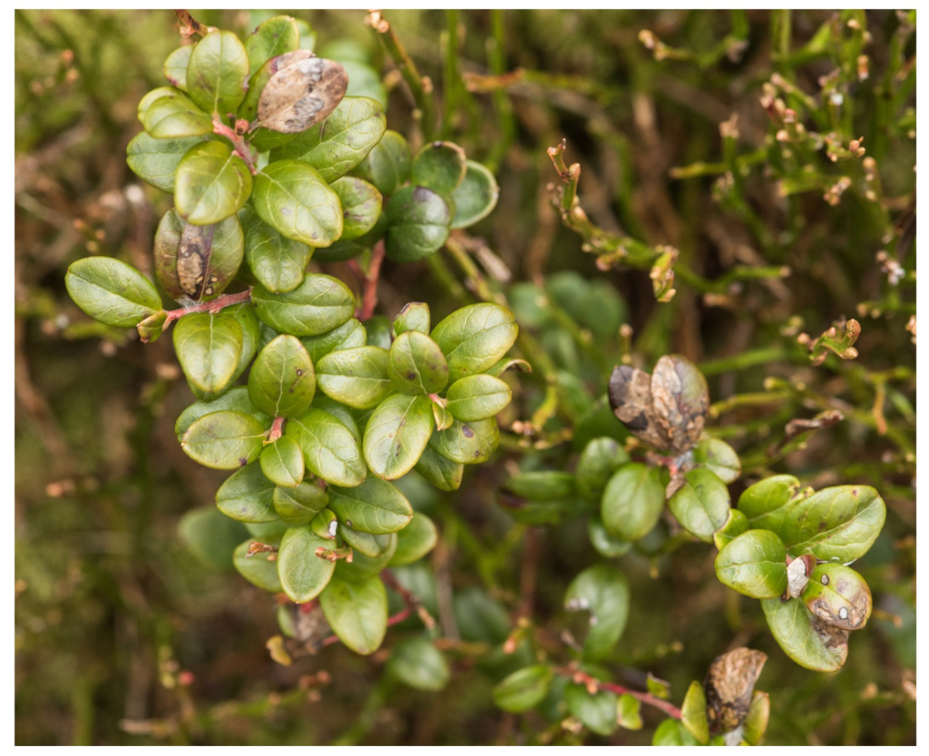

Image Gallery


Temporal Distribution Chart
Adults: (between 1994 - 2017) | Immatures: (between 1970 - 2025)
Distribution Map for Rhopobota ustomaculana
↳ from 2026+
↳ 6 from 2020 - 2025
↳ 4 from Before 2020
If the Map Layers function fails, just refresh the page and it should be OK after. Use the +- zoom on the top left, or on a tablet, use two fingers to zoom. Remember, the last layer you ticked is the one which displays the popup information - they sit on top of each other - de-select then re-select, to see the popup values.
Bedrock Geology ** indirectly affects moth distribution by influencing the type of habitat and food plants available in an area. In turn, this may affect the types of moths that can thrive, or where they can most likely be found.
NBN Atlas UK Distribution for – Rhopobota ustomaculana
⚠️ Please wait for the map to load fully – do not click the link shown.
Note – the NBN Atlas datasets are listed in the map below and vary in their currency (uptodateness) – however,
the map does give a general indication of the moth's distribution across the UK.
Monthly Records By Year:
Rhopobota ustomaculana
( data includes both Larvae and Adult Stages )
Monthly Counts By Year:
Rhopobota ustomaculana
( data is based on 'Adult' stage records only )
First/Last Recorded Dates: Rhopobota ustomaculana
Adult-only & Anything [Larvae, Pupae, Adult, Mines]
Shading shows moth presence between dates
Click the colour discs below to Select/De-select as Required
Recordings By Year: Rhopobota ustomaculana
( All data includes both Larvae and Adult Stages )
Annual Growth Rate (AGR): Rhopobota ustomaculana
AGR: 0% | Total % Change: 0%
Hectad (10kmx10km) Coverage: Rhopobota ustomaculana
( data includes both Larvae and Adult Stages )
Flight Periods – Indicative –vs– Recorded Data
Rhopobota ustomaculana
Rhopobota ustomaculana
Flight Period chart – the grey hatched area above, which can cross one or more months, pictorially represents the best guess we have for this moth's flight periods [month/s]. The coloured lines represent the actual months seen in flight, from site observation records received between 2020-2026.
Mine Periods – Indicative –vs– Recorded Data
Rhopobota ustomaculana
Rhopobota ustomaculana
( data includes both Larvae and Adult Stages )
Mine Period chart – the grey hatched area above, which can cross one or more months, pictorially represents the best guess we have for this moth's mine periods [month/s]. The coloured lines represent the actual months seen mining, from site observation records received between 2020-2026.
Records Behind the Map and Charts - Rhopobota ustomaculana – 10 records available
Listed by Year - descending - scroll across to see all table columns
| Site Name | Tetrad | Date | Count | Stage | Recorder | Source | RecordKey |
|---|---|---|---|---|---|---|---|
| Leygatehead & Middle Moor above Little Hayfield | SK08P | 11/04/2025 | 1 | Leaf-mine | Heintzen, Christian | vc57_irecords_extract | iBRC43978951 |
| Kinder Scout, western slopes below Kinder Downfall | SK08U | 12/03/2025 | 10 | larva | Heintzen, Christian | vc57_irecords_extract | iBRC40399476 |
| Kinder Scout, western slopes below Kinder Downfall | SK08U | 12/03/2025 | 20 | larva | Heintzen, Christian | vc57_irecords_extract | iBRC40399478 |
| Kinder Scout, Seal Edge | SK18E | 26/02/2025 | 1 | Larva | Heintzen, Christian | vc57_irecords_extract | iBRC40322244 |
| Bray Clough | SK09K | 17/01/2025 | 3 | Larva | Heintzen, Christian | vc57_irecords_extract | iBRC40053330 |
| Olwer Tor | SK28K | 12/09/2024 | 1 | Mine | Jack Oughton | vc57_irecords_extract | iBRC39791148 |
| Burbage Valley and Houndkirk Moor | SK28Q | 04/12/2017 | 2 | Larva | Watchorn, Andrew | vc57_irecords_extract | iBRC6269511 |
| Blacka Moor and Plantation | SK28V | 14/11/2017 | 1 | Adult | Watchorn, Andrew | vc57_irecords_extract | iBRC6208944 |
| Beeley Triangle (site not precise) | SK26Z | 27/07/1994 | 1 | Adult | VC57 Derbyshire Recorder | vc57_danes_bc_data | LC000334001CP147 |
| nr Eyam Moor | SK27J | 17/05/1970 | 1 | Larvae | VC57 Derbyshire Recorder | vc57_danes_bc_data | LC000334001COQI2 |