
 Leaf-miner: CAT L – The leaf or a Photo required –
  Larval Case: C1 – Distinctive Species –
  – click for General Verification Guidelines | – click for Specific Verification Guidelines
  – Generally Common / Widespread
  – Leaf-miner
Confusion Species: Stigmella tityrella
Mine Period Additional: Leaf mine June and August – September
Mine ID Difficulty:
Mine Type/s: Gallery
Mine Feeding Method/s: Not Recorded
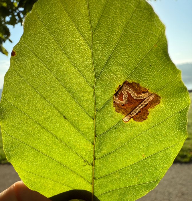
Mine Comment: The species is most often identified by the unique mine created by its larva within a beech leaf. The larva is whitish-yellow with a pale brown head. The mine is a sinuous, untidy gallery that typically starts near the leaf margin and moves towards the midrib, often crossing veins. A key distinguishing feature is a section in the middle of the mine where the frass is coiled into arcs or a central coil. The mine has the egg displaced from the midrib (central main vein of the leaf), unlike Stigmella tityrella, which has the egg on the underside against the midrib also other pointers are the overall shape of the mine. Moving a lot more along the length of the leaf than tityrella would. The mines of tityrella are usually tightly confined between two side veins.
Blue-coded] moths is not displayed/updated in this tab. However, all verified records for this moth are listed in the RECORDS tab below. 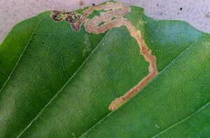


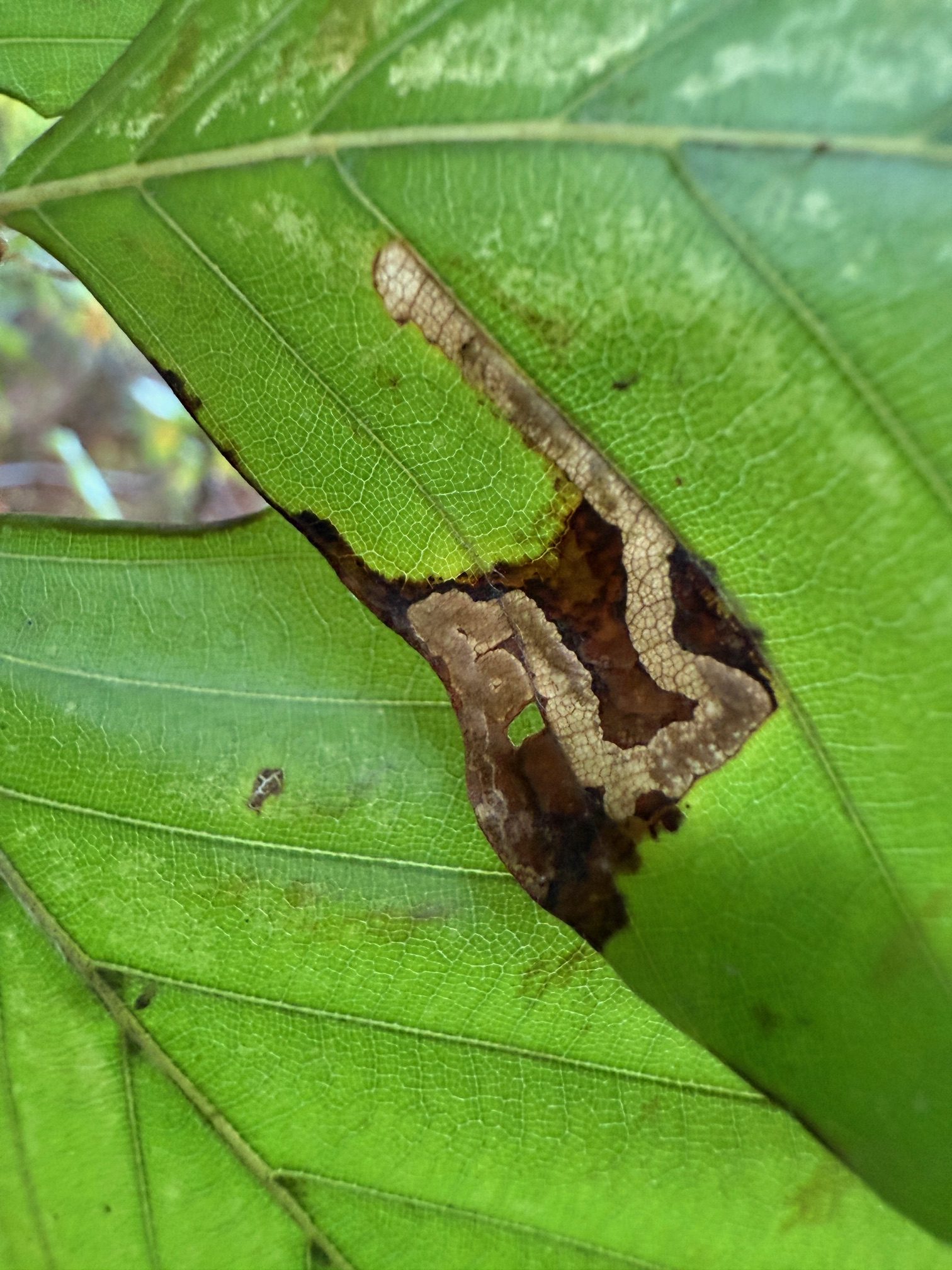


Image Gallery


Temporal Distribution Chart
Adults: (between 2024 - 2025) | Immatures: (between 2001 - 2025)
Distribution Map for Stigmella hemargyrella
↳ from 2026+
↳ 30 from 2020 - 2025
↳ 23 from Before 2020
If the Map Layers function fails, just refresh the page and it should be OK after. Use the +- zoom on the top left, or on a tablet, use two fingers to zoom. Remember, the last layer you ticked is the one which displays the popup information - they sit on top of each other - de-select then re-select, to see the popup values.
Bedrock Geology ** indirectly affects moth distribution by influencing the type of habitat and food plants available in an area. In turn, this may affect the types of moths that can thrive, or where they can most likely be found.
NBN Atlas UK Distribution for – Stigmella hemargyrella
⚠️ Please wait for the map to load fully – do not click the link shown.
Note – the NBN Atlas datasets are listed in the map below and vary in their currency (uptodateness) – however,
the map does give a general indication of the moth's distribution across the UK.
Monthly Records By Year:
Stigmella hemargyrella
( data includes both Larvae and Adult Stages )
Monthly Counts By Year:
Stigmella hemargyrella
( data is based on 'Adult' stage records only )
First/Last Recorded Dates: Stigmella hemargyrella
Adult-only & Anything [Larvae, Pupae, Adult, Mines]
Shading shows moth presence between dates
Click the colour discs below to Select/De-select as Required
Recordings By Year: Stigmella hemargyrella
( All data includes both Larvae and Adult Stages )
Annual Growth Rate (AGR): Stigmella hemargyrella
AGR: 3.72% | Total % Change: 140%
Hectad (10kmx10km) Coverage: Stigmella hemargyrella
( data includes both Larvae and Adult Stages )
Flight Periods – Indicative –vs– Recorded Data
Stigmella hemargyrella
Stigmella hemargyrella
Flight Period chart – the grey hatched area above, which can cross one or more months, pictorially represents the best guess we have for this moth's flight periods [month/s]. The coloured lines represent the actual months seen in flight, from site observation records received between 2020-2026.
Mine Periods – Indicative –vs– Recorded Data
Stigmella hemargyrella
Stigmella hemargyrella
( data includes both Larvae and Adult Stages )
Mine Period chart – the grey hatched area above, which can cross one or more months, pictorially represents the best guess we have for this moth's mine periods [month/s]. The coloured lines represent the actual months seen mining, from site observation records received between 2020-2026.
Records Behind the Map and Charts - Stigmella hemargyrella – 53 records available
Listed by Year - descending - scroll across to see all table columns
| Site Name | Tetrad | Date | Count | Stage | Recorder | Source | RecordKey |
|---|---|---|---|---|---|---|---|
| Staunton Harold Reservoir, Derbyshire | SK32S | 28/10/2025 | 4 | mine | Davison, Tony | vc57_irecords_extract | iBRC46136312 |
| Staunton Harold Reservoir, Derbyshire | SK32S | 25/10/2025 | 2 | mine (empty) | Davison, Tony | vc57_irecords_extract | iBRC48131936 |
| Little Hayfield, Park Hall Woodland | SK08J | 21/10/2025 | 2 | Leaf-mine | Heintzen, Christian | vc57_irecords_extract | iBRC47521370 |
| Longdendale, Woodhead, Trans Pennine Trail | SK19E | 10/10/2025 | 1 | Leaf-mine | Heintzen, Christian | vc57_irecords_extract | iBRC47521363 |
| Darwin Forest | SK36C | 06/10/2025 | 4 | mine (tenant | Evans, Dave | vc57_irecords_extract | iBRC45819789 |
| Hillside Plantation, Buxton | SK07K | 12/09/2025 | 1 | mine | Mortin, Jon | vc57_irecords_extract | iBRC50533643 |
| DWT Wyver Lane | SK34P | 02/09/2025 | 8 | mine (empty) | Evans, Dave | vc57_irecords_extract | iBRC45019768 |
| Serpentine Woods (north),Buxton | SK07L | 01/09/2025 | 1 | Adult | Mortin, Jon | vc57_irecords_extract | iBRC46048896 |
| Shillito Wood | SK27X | 28/08/2025 | 5 | mine (empty) | Watchorn, Andrew | vc57_irecords_extract | iBRC44968097 |
| Shallcross Wood, Taxal | SK07E | 26/08/2025 | 1 | mine | Mortin, Jon | vc57_irecords_extract | iBRC44790355 |
| Graves Park, Sheffield | SK38L | 26/08/2025 | 1 | mine | Mella, Pete | vc57_irecords_extract | iBRC44859436 |
| Norton Lees, Sheffield | SK38L | 15/08/2025 | 1 | adult | Mella, Pete | vc57_irecords_extract | iBRC44507834 |
| DWT Wyver Lane | SK34P | 13/08/2025 | 3 | mine (empty) | Evans, Dave | vc57_irecords_extract | iBRC44440718 |
| Gleadless Valley LNR | SK38R | 28/07/2025 | 1 | mine | Mella, Pete | vc57_irecords_extract | iBRC43961638 |
| Graves Park | SK38K | 04/07/2025 | 1 | mine | Mella, Pete | vc57_irecords_extract | iBRC43011876 |
| Crich Lane Woods | SK34P | 19/10/2024 | 15 | mine (empty) | Evans, Dave | vc57_irecords_extract | iBRC38983695 |
| Monsall Trail | SK17L | 14/10/2024 | 1 | mine (empty) | Harvey, Martin C. | vc57_irecords_extract | iBRC38900296 |
| Ashwood Park, Buxton | SK07R | 12/10/2024 | 1 | mine | Mortin, Jon | vc57_irecords_extract | iBRC38844136 |
| Darwin Forest | SK36C | 02/10/2024 | 15 | mine (empty) | Evans, Dave | vc57_irecords_extract | iBRC38743121 |
| Cote Heath Woods | SK07R | 14/09/2024 | 1 | mine | Mortin, Jon | vc57_irecords_extract | iBRC38461325 |
| Foxlow Wood, Buxton | SK07R | 13/09/2024 | 3 | mine | Mortin, Jon | vc57_irecords_extract | iBRC38448944 |
| Sherbrook Wood, Buxton | SK07R | 13/09/2024 | 1 | Adult | Mortin, Jon | vc57_irecords_extract | iBRC38748617 |
| Cote Heath Wood | SK07L | 10/09/2024 | 1 | mine | Mortin, Jon | vc57_irecords_extract | iBRC38411383 |
| Foxlow Wood, Buxton | SK07R | 19/07/2024 | 1 | Adult | Mortin, Jon | vc57_irecords_extract | iBRC38850379 |
| Calke Park | SK32R | 07/10/2023 | 1 | Mine | Finch, Graham Leonard | vc57_irecords_extract | iBRC35105499 |
| Calke Park | SK32R | 01/10/2023 | 1 | Mine | Finch, Graham Leonard | vc57_irecords_extract | iBRC35105527 |
| Hogshaw Wood | SK07S | 06/09/2023 | 1 | mine | Mortin, Jon | vc57_irecords_extract | iBRC32857440 |
| Temple Fields, Buxton | SK07L | 03/09/2023 | 1 | Larva | Mortin, Jon | vc57_irecords_extract | iBRC38899921 |
| Fairholmes | SK18U | 11/02/2023 | 1 | mine | Shenton, David | vc57_irecords_extract | iBRC29386262 |
| Ashwood Park, Buxton | SK07R | 25/07/2020 | 1 | Larva | Mortin, Jon | vc57_irecords_extract | iBRC38900137 |
| Grange Wood | SK21S | 13/09/2018 | 1 | Mine | Finch, Graham Leonard | vc57_irecords_extract | iBRC35106427 |
| Millers Dale | SK17G | 03/09/2011 | 1 | Larval Mine | S.H. Hind | vc57_danes_bc_data | LC000334001COU5I |
| Thorpe, Dovedale | SK15K | 13/10/2010 | 1 | Larval Mine | S.A. Orridge;S.H. Hind | vc57_danes_bc_data | LC000334001COTQU |
| Kirk Dale, Ashford in the Water | SK16Z | 22/09/2010 | 1 | Larva | Orridge, Steve | vc57_irecords_extract | iBRC44257388 |
| Ashford in the Water | SK16Z | 22/09/2010 | 1 | Larval Mine | S.A. Orridge;S.H. Hind | vc57_danes_bc_data | LC000334001COZGL |
| Ladybower Resr | SK18U | 03/09/2010 | 1 | Larval Mine | S.H. Hind | vc57_danes_bc_data | LC000334001COXIS |
| Howden Resr | SK19L | 25/08/2010 | 1 | Larval Mine | S.H. Hind | vc57_danes_bc_data | LC000334001CP09C |
| Howden Resr | SK19S | 25/08/2010 | 1 | Larval Mine | S.H. Hind | vc57_danes_bc_data | LC000334001COXI0 |
| Padley Gorge, Nether Padley | SK27P | 19/08/2010 | 1 | Larval Mine | S.H. Hind | vc57_danes_bc_data | LC000334001COXGV |
| Cromford | SK25Y | 16/10/2009 | 1 | Larval Mine | Dave Budworth;S.A. Orridge;S.H. Hind | vc57_danes_bc_data | LC000334001CP55T |
| Linacre Wood | SK37G | 13/10/2009 | 1 | Larval Mine | S.H. Hind | vc57_danes_bc_data | LC000334001CP54H |
| Stoney Middleton | SK27H | 12/10/2009 | 1 | Larval Mine | S.H. Hind | vc57_danes_bc_data | LC000334001COWZO |
| Hope | SK18R | 07/10/2009 | 1 | Larval Mine | S.H. Hind | vc57_danes_bc_data | LC000334001COSZR |
| Derbyshire, UK | SK14G | 02/10/2009 | 1 | Larva | Orridge, Steve | vc57_irecords_extract | iBRC44257394 |
| Norbury | SK14G | 01/10/2009 | 1 | Larval Mine | Dave Budworth;S.A. Orridge;S.H. Hind | vc57_danes_bc_data | LC000334001COWY8 |
| Castleton | SK18L | 10/09/2009 | 1 | Larval Mine | S.H. Hind | vc57_danes_bc_data | LC000334001COWX6 |
| Calke Park | SK32L | 25/10/2008 | 1 | Mine | Finch, Graham Leonard | vc57_irecords_extract | iBRC35105473 |
| Calke Park,Ticknall | SK32R | 25/10/2008 | 1 | Larval Mine | VC57 Derbyshire Recorder | vc57_danes_bc_data | LC000334001COSOR |
| Oaks Barn Cottage, Monyash Rd, Over Haddon, Bakewell | SK26D | 19/09/2008 | 1 | Larval Mine | Dave Budworth;S.H. Hind | vc57_danes_bc_data | LC000334001CP4M2 |
| Ogston Carr Wood,nr Ogston Res | SK35U | 12/07/2006 | 1 | Larval Mine | S.H. Hind | vc57_danes_bc_data | LC000334001CORSQ |
| Hillclifflane, nr Idridgehay | SK24Y | 02/11/2002 | 1 | Larval Mine | S.H. Hind | vc57_danes_bc_data | LC000334001CP1HH |
| Brackley Gate, nr Coxbench | SK34W | 03/11/2001 | 1 | Larval Mine | S.H. Hind | vc57_danes_bc_data | LC000334001COR0J |
| Abbotsholme School, Rocester | SK13E | 04/10/2001 | 1 | Larval Mine | S.H. Hind | vc57_danes_bc_data | LC000334001CP1ES |