
 Leaf-miner: CAT L – The leaf or a Photo required –
  Larval Case: C1 – Distinctive Species –
  – click for General Verification Guidelines | – click for Specific Verification Guidelines
  – Uncertain/Unknown – Insufficient Data
  – Leaf-miner
The adult moth is tiny and it is generally dark purplish with a distinctive whitish fascia (band) across its wings, an orange head, and white eyecaps. The adult moths are difficult to identify solely by appearance and often require dissection or rearing from their leaf mines for definitive identification.
Mine Period Additional: Mines can typically be found in July and again from September to October, corresponding to the two generations per year (adults fly in May/June and August).
Mine ID Difficulty:
Mine Type/s: Gallery, Blotch
Mine Feeding Method/s: Not Recorded
Mine Comment: The larva creates a mine within the bilberry leaf that begins as a long, contorted gallery (tunnel) with a central line of frass (excrement). This initial gallery then widens to form a “false blotch”. The leaf tissue around the mine often turns purple. The larvae are amber-yellow with a brown head.
Chunal Moor, Glossop (August 2025) and Longdendale Sept and Oct 2025 Christian Heintzen©
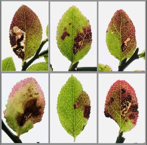


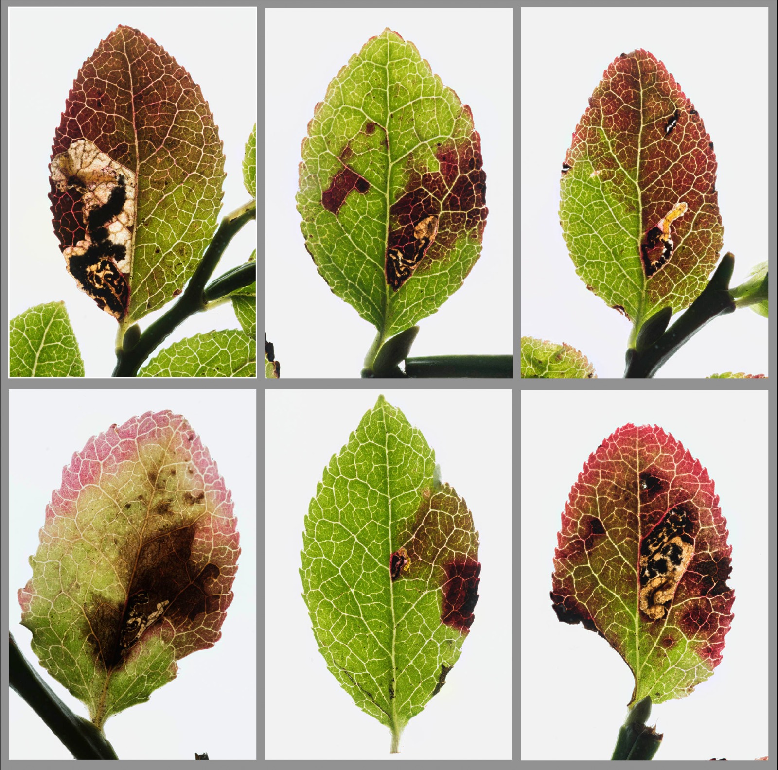


Image Gallery


Temporal Distribution Chart
Immatures: (between 2010 - 2025)
Distribution Map for Stigmella myrtillella
↳ from 2026+
↳ 9 from 2020 - 2025
↳ 5 from Before 2020
If the Map Layers function fails, just refresh the page and it should be OK after. Use the +- zoom on the top left, or on a tablet, use two fingers to zoom. Remember, the last layer you ticked is the one which displays the popup information - they sit on top of each other - de-select then re-select, to see the popup values.
Bedrock Geology ** indirectly affects moth distribution by influencing the type of habitat and food plants available in an area. In turn, this may affect the types of moths that can thrive, or where they can most likely be found.
NBN Atlas UK Distribution for – Stigmella myrtillella
⚠️ Please wait for the map to load fully – do not click the link shown.
Note – the NBN Atlas datasets are listed in the map below and vary in their currency (uptodateness) – however,
the map does give a general indication of the moth's distribution across the UK.
Monthly Records By Year:
Stigmella myrtillella
( data includes both Larvae and Adult Stages )
Monthly Counts By Year:
Stigmella myrtillella
( data is based on 'Adult' stage records only )
First/Last Recorded Dates: Stigmella myrtillella
Adult-only & Anything [Larvae, Pupae, Adult, Mines]
Shading shows moth presence between dates
Click the colour discs below to Select/De-select as Required
Recordings By Year: Stigmella myrtillella
( All data includes both Larvae and Adult Stages )
Annual Growth Rate (AGR): Stigmella myrtillella
AGR: 5.56% | Total % Change: 125%
Hectad (10kmx10km) Coverage: Stigmella myrtillella
( data includes both Larvae and Adult Stages )
Flight Periods – Indicative –vs– Recorded Data
Stigmella myrtillella
Stigmella myrtillella
Flight Period chart – the grey hatched area above, which can cross one or more months, pictorially represents the best guess we have for this moth's flight periods [month/s]. The coloured lines represent the actual months seen in flight, from site observation records received between 2020-2026.
Mine Periods – Indicative –vs– Recorded Data
Stigmella myrtillella
Stigmella myrtillella
( data includes both Larvae and Adult Stages )
Mine Period chart – the grey hatched area above, which can cross one or more months, pictorially represents the best guess we have for this moth's mine periods [month/s]. The coloured lines represent the actual months seen mining, from site observation records received between 2020-2026.
Records Behind the Map and Charts - Stigmella myrtillella – 14 records available
Listed by Year - descending - scroll across to see all table columns
| Site Name | Tetrad | Date | Count | Stage | Recorder | Source | RecordKey |
|---|---|---|---|---|---|---|---|
| Longdendale, Trans Pennine Trail, Woodhead, Reservoir | SK19E | 10/10/2025 | 3 | Leaf-mine | Heintzen, Christian | vc57_irecords_extract | iBRC47521362 |
| Longdendale,Bramah Edge | SK09N | 12/09/2025 | 1 | Leaf-mine | Heintzen, Christian | vc57_irecords_extract | iBRC47521356 |
| Longdendale,Bramah Edge | SK09N | 12/09/2025 | 2 | Leaf-mine | Heintzen, Christian | vc57_irecords_extract | iBRC47521357 |
| Longdendale,Bramah Edge, Torside Clough | SK09T | 12/09/2025 | 1 | Leaf-mine | Heintzen, Christian | vc57_irecords_extract | iBRC47521358 |
| Glossop, Gnat Hole | SK09L | 07/09/2025 | 2 | Leaf-mine | Heintzen, Christian | vc57_irecords_extract | iBRC47521354 |
| Longdendale, Wildboar Clough | SK09U | 03/09/2025 | 2 | Leaf-mine | Heintzen, Christian | vc57_irecords_extract | iBRC47521348 |
| Hayfield, Mount Famine | SK08M | 02/09/2025 | 1 | Leaf-mine | Heintzen, Christian | vc57_irecords_extract | iBRC47521347 |
| Glossop, Chunal Moor | SK09F | 31/08/2025 | 6 | Leaf-mine | Heintzen, Christian | vc57_irecords_extract | iBRC47521343 |
| Nether North Grain, Snake Road | SK19B | 24/08/2025 | 2 | Larva | Neil Sherman | vc57_irecords_extract | iBRC48244974 |
| Ladybower Resr | SK18U | 03/09/2010 | 1 | Larval Mine | S.H. Hind | vc57_danes_bc_data | LC000334001COXIX |
| Howden Resr | SK19L | 25/08/2010 | 1 | Larval Mine | S.H. Hind | vc57_danes_bc_data | LC000334001CP09F |
| Slippery Stones,Upper Derwent | SK19S | 25/08/2010 | 1 | Larval Mine | S.H. Hind | vc57_danes_bc_data | LC000334001COXIM |
| Padley Gorge, Nether Padley | SK27P | 19/08/2010 | 1 | Larval Mine | S.H. Hind | vc57_danes_bc_data | LC000334001COXH0 |
| Owler Tor, nr Hathersage | SK28K | 19/08/2010 | 1 | Larval Mine | S.H. Hind | vc57_danes_bc_data | LC000334001COXH4 |