
 Leaf-miner: CAT R – Moth will need to be reared and possibly dissected – Larval Case: C1 – Distinctive Species –
  – click for General Verification Guidelines | – click for Specific Verification Guidelines
  – Generally Common / Widespread
  – Leaf-miner
Mine Period Additional: Leaf Mine – June and July & August – October
Mine ID Difficulty:
Mine Type/s: Gallery
Mine Feeding Method/s: N/A
Mine Comment: Best identified by the way the larva feed, creating an S-shaped mine, usually within the confines of two veins, leaving a diagnostic feeding pattern in the leaves. The egg is laid on the underside of the leaf against the mid-rib amongst hairs in the angle with the leaf vein. In the similar looking mine of Stigmella hemargyrella the egg is positioned away from mid-rib. During the autumn it is a good time to find the mines of Stigmella tityrella on the ground amongst fallen beech leaves, easily discovered as a so called “Green Island” on an otherwise brown beech leaf. The mines are nearly always vacated but some are still tenanted. Many of the larvae in the tenanted mines are parasitised and some still contain the larva of most probably a parasitic wasp, actively devouring its host.
Blue-coded] moths is not displayed/updated in this tab. However, all verified records for this moth are listed in the RECORDS tab below. 

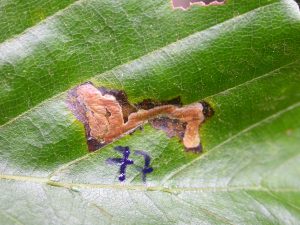


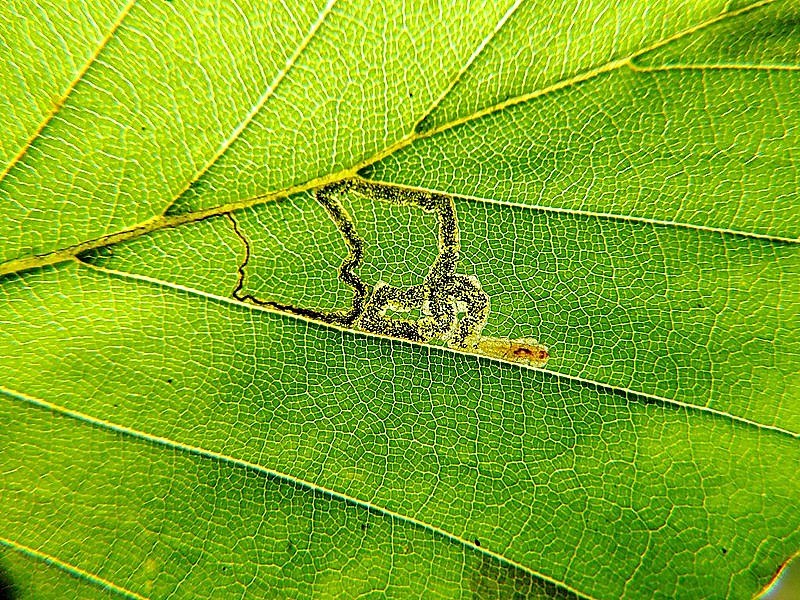


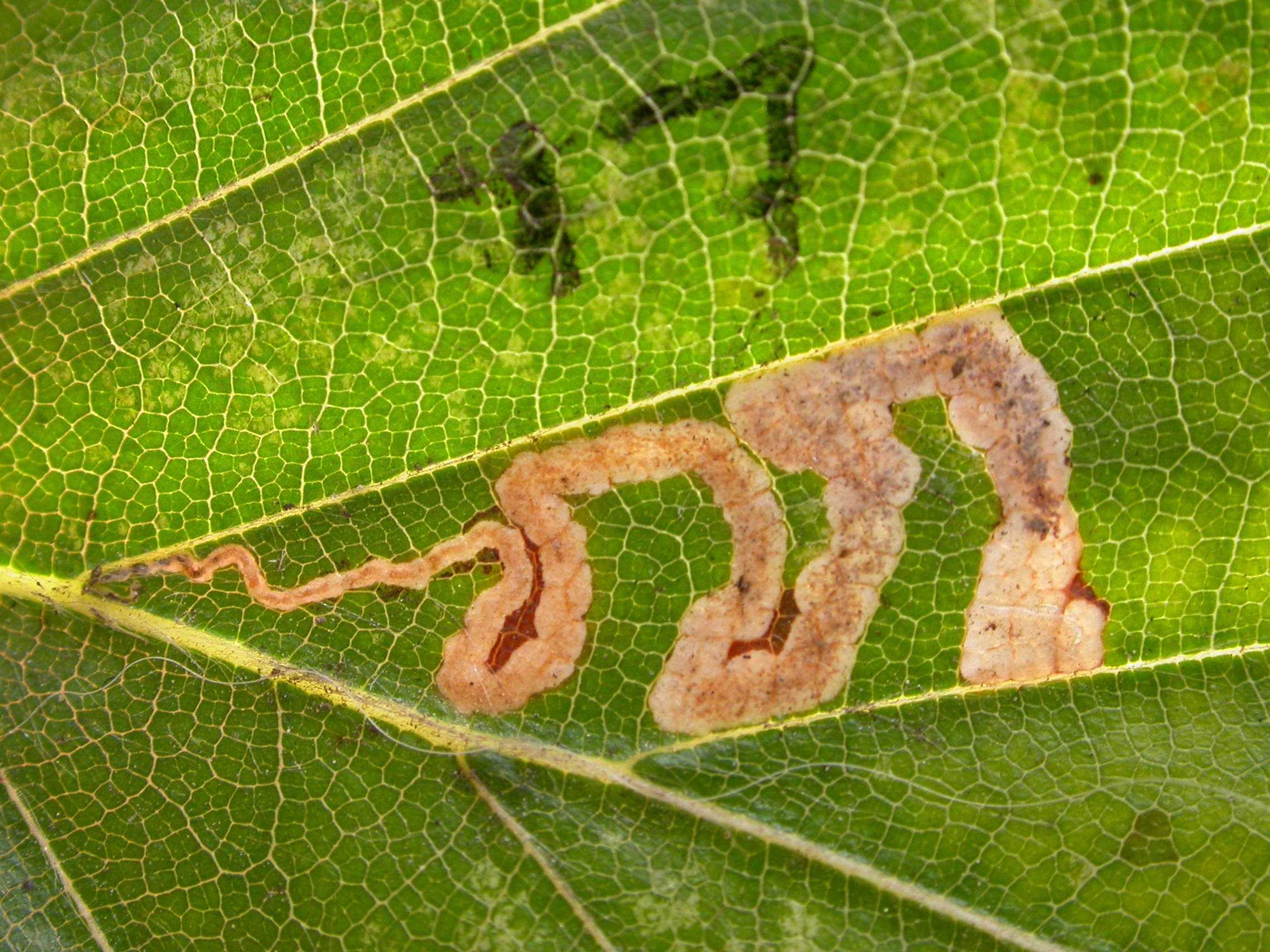
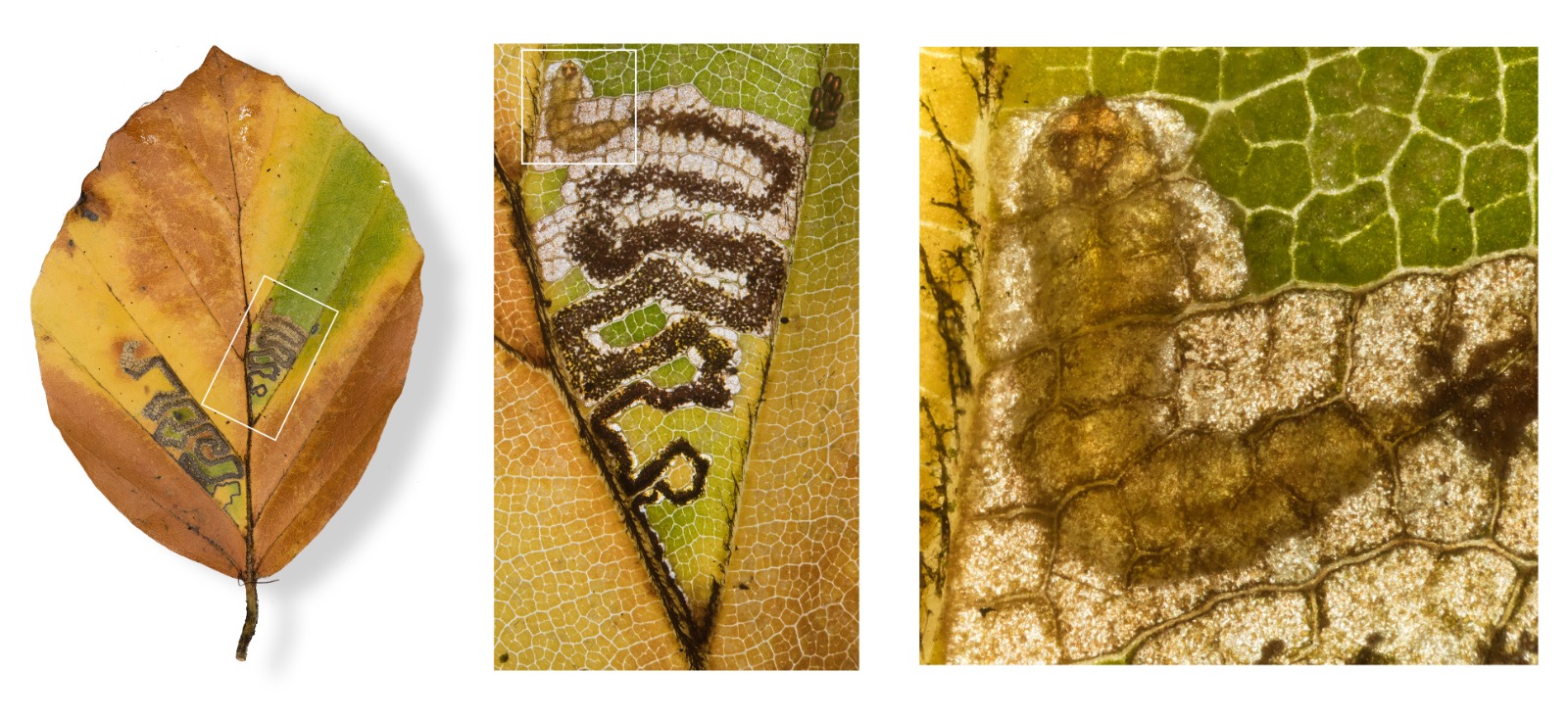


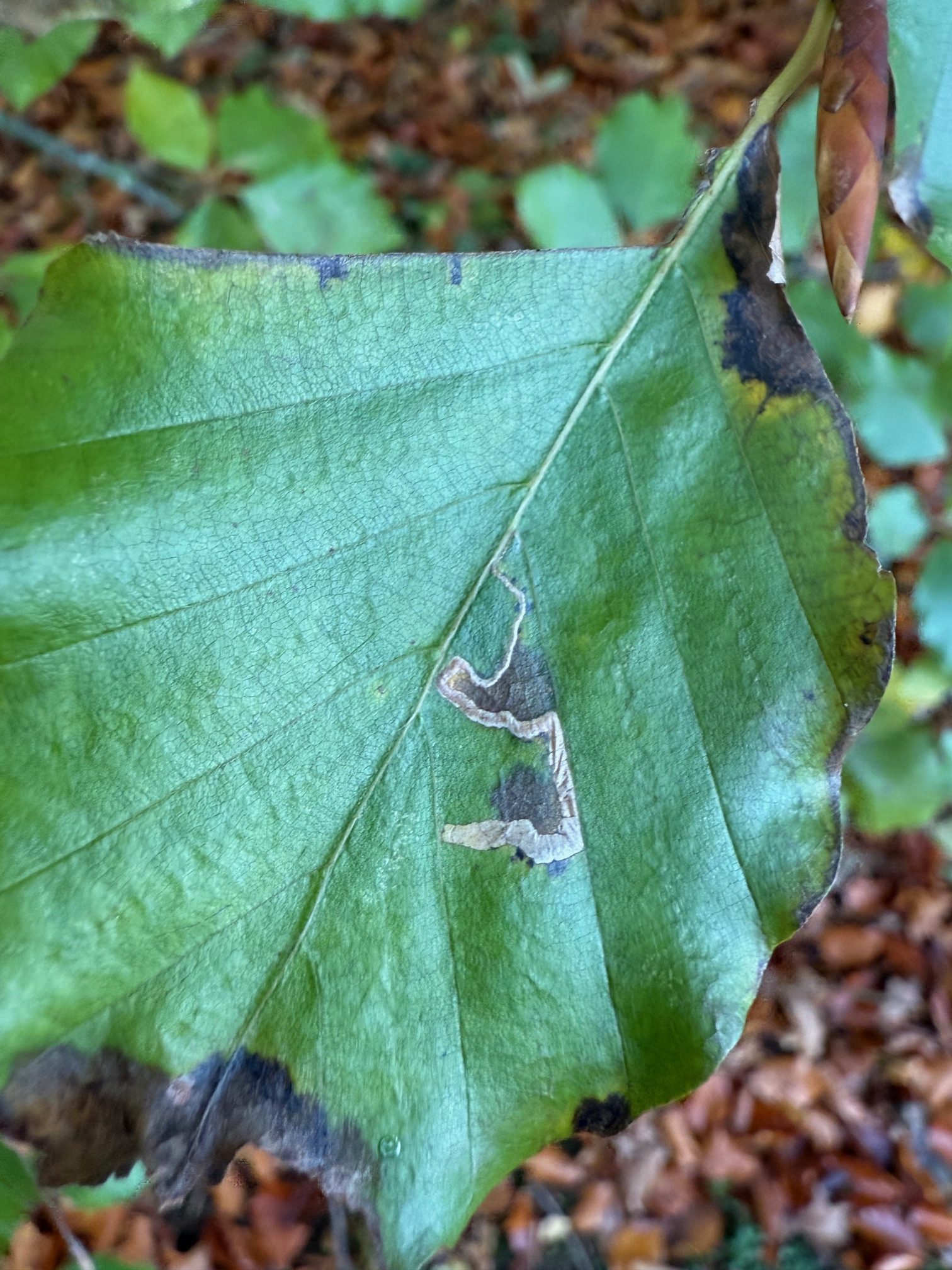

Image Gallery


Temporal Distribution Chart
Adults: (between 2016 - 2025) | Immatures: (between 2001 - 2025)
Distribution Map for Stigmella tityrella
↳ from 2026+
↳ 61 from 2020 - 2025
↳ 30 from Before 2020
If the Map Layers function fails, just refresh the page and it should be OK after. Use the +- zoom on the top left, or on a tablet, use two fingers to zoom. Remember, the last layer you ticked is the one which displays the popup information - they sit on top of each other - de-select then re-select, to see the popup values.
Bedrock Geology ** indirectly affects moth distribution by influencing the type of habitat and food plants available in an area. In turn, this may affect the types of moths that can thrive, or where they can most likely be found.
NBN Atlas UK Distribution for – Stigmella tityrella
⚠️ Please wait for the map to load fully – do not click the link shown.
Note – the NBN Atlas datasets are listed in the map below and vary in their currency (uptodateness) – however,
the map does give a general indication of the moth's distribution across the UK.
Monthly Records By Year:
Stigmella tityrella
( data includes both Larvae and Adult Stages )
Monthly Counts By Year:
Stigmella tityrella
( data is based on 'Adult' stage records only )
First/Last Recorded Dates: Stigmella tityrella
Adult-only & Anything [Larvae, Pupae, Adult, Mines]
Shading shows moth presence between dates
Click the colour discs below to Select/De-select as Required
Recordings By Year: Stigmella tityrella
( All data includes both Larvae and Adult Stages )
Annual Growth Rate (AGR): Stigmella tityrella
AGR: 7.67% | Total % Change: 488.9%
Hectad (10kmx10km) Coverage: Stigmella tityrella
( data includes both Larvae and Adult Stages )
Flight Periods – Indicative –vs– Recorded Data
Stigmella tityrella
Stigmella tityrella
Flight Period chart – the grey hatched area above, which can cross one or more months, pictorially represents the best guess we have for this moth's flight periods [month/s]. The coloured lines represent the actual months seen in flight, from site observation records received between 2020-2026.
Mine Periods – Indicative –vs– Recorded Data
Stigmella tityrella
Stigmella tityrella
( data includes both Larvae and Adult Stages )
Mine Period chart – the grey hatched area above, which can cross one or more months, pictorially represents the best guess we have for this moth's mine periods [month/s]. The coloured lines represent the actual months seen mining, from site observation records received between 2020-2026.
Records Behind the Map and Charts - Stigmella tityrella – 91 records available
Listed by Year - descending - scroll across to see all table columns
| Site Name | Tetrad | Date | Count | Stage | Recorder | Source | RecordKey |
|---|---|---|---|---|---|---|---|
| Upper Derwent Valley, Slippery Stones | SK19S | 10/11/2025 | 12 | Leaf-mine | Heintzen, Christian | vc57_irecords_extract | iBRC47521385 |
| Woodlands Valley, Hagg Farm | SK18U | 04/11/2025 | 2 | Leaf-mine | Heintzen, Christian | vc57_irecords_extract | iBRC47521380 |
| Hayfield Elle Bank Wood | SK08N | 02/11/2025 | 1 | Leaf-mine | Heintzen, Christian | vc57_irecords_extract | iBRC47521376 |
| Staunton Harold Reservoir, Derbyshire | SK32S | 28/10/2025 | 1 | mine | Davison, Tony | vc57_irecords_extract | iBRC46136313 |
| Staunton Harold Reservoir, Derbyshire | SK32S | 25/10/2025 | 4 | mine (empty) | Davison, Tony | vc57_irecords_extract | iBRC46085056 |
| Darwin Forest | SK36C | 06/10/2025 | 35 | mine (empty) | Evans, Dave | vc57_irecords_extract | iBRC45819788 |
| Darwin Forest | SK26X | 04/10/2025 | 6 | mine (empty) | Evans, Dave | vc57_irecords_extract | iBRC45786888 |
| Staveley, Derbyshire | SK47H | 04/10/2025 | 10 | mine | Radford, Mark | vc57_irecords_extract | iBRC45790451 |
| Glossop, DWT Long Clough | SK09G | 06/09/2025 | 1 | Leaf-mine | Heintzen, Christian | vc57_irecords_extract | iBRC47521352 |
| DWT Wyver Lane | SK34P | 02/09/2025 | 3 | mine (empty) | Evans, Dave | vc57_irecords_extract | iBRC45019767 |
| Serpentine Woods (north),Buxton | SK07L | 01/09/2025 | 1 | Adult | Mortin, Jon | vc57_irecords_extract | iBRC45035182 |
| Great Hucklow, Buxton SKRQ, UK | SK17Y | 27/08/2025 | 1 | Adult | Moores, Stephen | vc57_irecords_extract | iBRC45127443 |
| DWT Wyver Lane | SK34P | 13/08/2025 | 5 | mine (empty) | Evans, Dave | vc57_irecords_extract | iBRC44440717 |
| DWT Wyver Lane | SK34P | 06/08/2025 | 5 | mine (empty) | Evans, Dave | vc57_irecords_extract | iBRC44213439 |
| Norton Lees, Sheffield | SK38L | 28/07/2025 | 1 | mine | Mella, Pete | vc57_irecords_extract | iBRC43961795 |
| Gadley Plantation (north), Buxton | SK07L | 23/07/2025 | 2 | mine | Mortin, Jon | vc57_irecords_extract | iBRC43747835 |
| DWT Wyver Lane | SK34P | 23/07/2025 | 15 | mine (empty) | Evans, Dave | vc57_irecords_extract | iBRC43746925 |
| Norton Lees | SK38L | 07/07/2025 | 1 | mine | Mella, Pete | vc57_irecords_extract | iBRC43107606 |
| Glossop, Gnat Hole woods | SK09G | 14/11/2024 | 1 | larva | Heintzen, Christian | vc57_irecords_extract | iBRC39768293 |
| Pottery Wood | SK32G | 05/11/2024 | 1 | Mine | Finch, Graham Leonard | vc57_irecords_extract | iBRC41038945 |
| Hillside Plantation, Derbyshire | SK07K | 25/10/2024 | 1 | mine | Mortin, Jon | vc57_irecords_extract | iBRC38992272 |
| Crich Lane Woods | SK34P | 19/10/2024 | 18 | mine (empty) | Evans, Dave | vc57_irecords_extract | iBRC38983694 |
| Calke Abbey | SK32R | 16/10/2024 | 1 | mine | Harvey, Martin C. | vc57_irecords_extract | iBRC38901116 |
| Chee Dale | SK17G | 15/10/2024 | 1 | mine | Harvey, Martin C. | vc57_irecords_extract | iBRC38900830 |
| Monsall Trail | SK17L | 14/10/2024 | 1 | mine (empty) | Harvey, Martin C. | vc57_irecords_extract | iBRC38900297 |
| Ashwood Park, Buxton | SK07R | 12/10/2024 | 1 | mine | Mortin, Jon | vc57_irecords_extract | iBRC38844135 |
| Darwin Forest | SK36C | 02/10/2024 | 17 | mine (empty) | Evans, Dave | vc57_irecords_extract | iBRC38743120 |
| Beresford Dale | SK15J | 24/09/2024 | 1 | Larva | Moores, Stephen | vc57_irecords_extract | iBRC38620218 |
| Bunsal Cob, Goyt Valley | SK07C | 16/09/2024 | 1 | mine | Mortin, Jon | vc57_irecords_extract | iBRC40508654 |
| Fern Wood, Buxton | SK07K | 15/09/2024 | 1 | mine | Mortin, Jon | vc57_irecords_extract | iBRC38723703 |
| Long Lane, High Peak, England, GB | SK08K | 15/09/2024 | 1 | mine | purplesusieq | vc57_irecords_extract | iBRC38723702 |
| Cote Heath Woods | SK07R | 14/09/2024 | 1 | mine | Mortin, Jon | vc57_irecords_extract | iBRC38461324 |
| Foxlow Fields Wood | SK07Q | 13/09/2024 | 1 | mine | Mortin, Jon | vc57_irecords_extract | iBRC38449521 |
| Sherbrook Lodge | SK07R | 13/09/2024 | 1 | mine | Mortin, Jon | vc57_irecords_extract | iBRC38448861 |
| DWT Wyver Lane | SK34P | 12/09/2024 | 13 | mine (empty) | Evans, Dave | vc57_irecords_extract | iBRC38431870 |
| Minster | SK26K | 11/09/2024 | 1 | Mine | Jack Oughton | vc57_irecords_extract | iBRC39791135 |
| Hogshaw Wood, Buxton | SK07S | 09/09/2024 | 1 | mine | Mortin, Jon | vc57_irecords_extract | iBRC38850274 |
| DWT Wyver Lane | SK34P | 04/09/2024 | 8 | mine (empty) | Evans, Dave | vc57_irecords_extract | iBRC38312554 |
| Sherbrook Lodge, Buxton | SK07R | 29/08/2024 | 1 | mine | Mortin, Jon | vc57_irecords_extract | iBRC38874750 |
| Pavilion Gardens, Buxton | SK07L | 23/07/2024 | 1 | mine | Mortin, Jon | vc57_irecords_extract | iBRC37261478 |
| Poppy Wood | SK32S | 22/11/2023 | 1 | Mine | Finch, Graham Leonard | vc57_irecords_extract | iBRC35107045 |
| Calke Park | SK32R | 07/10/2023 | 1 | Mine | Finch, Graham Leonard | vc57_irecords_extract | iBRC35105497 |
| Calke Park | SK32R | 01/10/2023 | 1 | Mine | Finch, Graham Leonard | vc57_irecords_extract | iBRC35105525 |
| Carver's Rocks | SK32H | 21/09/2023 | 1 | Mine | Finch, Graham Leonard | vc57_irecords_extract | iBRC35106102 |
| Gadley Wood, Buxton | SK07L | 09/09/2023 | 1 | Larva | Mortin, Jon | vc57_irecords_extract | iBRC38850588 |
| Otterhole Plantation, Buxton | SK07L | 09/09/2023 | 1 | Larva | Mortin, Jon | vc57_irecords_extract | iBRC38899920 |
| Temple Plantation, Buxton | SK07K | 08/09/2023 | 1 | Larva | Mortin, Jon | vc57_irecords_extract | iBRC38850587 |
| Corbar Woods, Buxton | SK07M | 06/09/2023 | 1 | Larva | Mortin, Jon | vc57_irecords_extract | iBRC38850586 |
| Sherbrook Wood, Buxton | SK07Q | 04/09/2023 | 1 | Larva | Mortin, Jon | vc57_irecords_extract | iBRC38850584 |
| Fairholmes | SK18U | 11/02/2023 | 3 | mine | Shenton, David | vc57_irecords_extract | iBRC29386261 |
| Dimminsdale Nature Reserve | SK32Q | 12/11/2022 | 7 | leafmine | Bell, Melinda | vc57_irecords_extract | iBRC28723377 |
| College Road, Buxton | SK07L | 02/11/2022 | 1 | mine (empty) | Mortin, Jon | vc57_irecords_extract | iBRC28640454 |
| Calke,Southwood | SK31U | 27/10/2022 | 10 | leafmine | Bell, Melinda | vc57_irecords_extract | iBRC28546758 |
| Derbyshire, UK | SK07X | 25/10/2022 | 1 | Larva | Orridge, Steve | vc57_irecords_extract | iBRC28945949 |
| Allestree Park | SK34K | 25/09/2022 | 1 | Mine | Finch, Graham Leonard | vc57_irecords_extract | iBRC35105358 |
| Chee Dale, Derbyshire | SK17G | 05/09/2022 | 1 | Larva | Mortin, Jon | vc57_irecords_extract | iBRC29428316 |
| Birch Vale | SK08I | 08/11/2021 | 3 | Mine | Hewitt, Jane | vc57_irecords_extract | iBRC34473018 |
| Crich Lane Woods | SK34P | 05/11/2021 | 15 | mine (tenant | Evans, Dave | vc57_irecords_extract | iBRC23093052 |
| Ashwood Park, Buxton | SK07R | 25/09/2021 | 1 | Larva | Mortin, Jon | vc57_irecords_extract | iBRC38900026 |
| Cote Heath Wood, Buxton | SK07L | 04/11/2020 | 1 | Larva | Mortin, Jon | vc57_irecords_extract | iBRC38900003 |
| North Lees Estate, Hathersage | SK28G | 25/07/2020 | 1 | mine | Watchorn, Andrew | vc57_irecords_extract | iBRC16661298 |
| Long Eaton | SK43X | 11/11/2019 | 1 | mine | Bryce, Marion | vc57_irecords_extract | iBRC12175264 |
| Grin Plantation, Buxton | SK07L | 21/10/2018 | 1 | Mine | Orridge, Steve | vc57_irecords_extract | iBRC49165539 |
| Blacka Moor and Plantation | SK28V | 27/07/2016 | 2 | mine | Watchorn, Andrew | vc57_irecords_extract | iBRC3920108 |
| Stanage Edge | SK28G | 22/07/2016 | 1 | Adult | Watchorn, Andrew | vc57_irecords_extract | iBRC3732553 |
| Millers Dale | SK17G | 03/09/2011 | 1 | Larval Mine | S.H. Hind | vc57_danes_bc_data | LC000334001COU5P |
| Thorpe, Dovedale | SK15K | 13/10/2010 | 1 | Larval Mine | S.A. Orridge;S.H. Hind | vc57_danes_bc_data | LC000334001COTR3 |
| Derbyshire, UK | SK16Z | 22/09/2010 | 1 | Larva | Orridge, Steve | vc57_irecords_extract | iBRC23065244 |
| Ashford in the Water | SK16Z | 22/09/2010 | 1 | Larval Mine | S.A. Orridge;S.H. Hind | vc57_danes_bc_data | LC000334001COZGP |
| Bamford | SK28B | 21/09/2010 | 1 | Larval Mine | K. McCabe;S.H. Hind | vc57_danes_bc_data | LC000334001COTQE |
| Ladybower Resr | SK18U | 03/09/2010 | 1 | Larval Mine | S.H. Hind | vc57_danes_bc_data | LC000334001COXJ4 |
| Howden Resr | SK19L | 25/08/2010 | 1 | Larval Mine | S.H. Hind | vc57_danes_bc_data | LC000334001CP09H |
| Howden Resr | SK19S | 25/08/2010 | 1 | Larval Mine | S.H. Hind | vc57_danes_bc_data | LC000334001COXI1 |
| Padley Gorge, Nether Padley | SK27P | 19/08/2010 | 1 | Larval Mine | S.H. Hind | vc57_danes_bc_data | LC000334001COXH3 |
| Newhall (William Allitt School) | SK22V | 06/08/2010 | 1 | Larval Mine | Dave Budworth | vc57_danes_bc_data | LC000334001COTJT |
| Linacre Wood | SK37G | 13/10/2009 | 1 | Larval Mine | S.H. Hind | vc57_danes_bc_data | LC000334001CP54P |
| Stoney Middleton | SK27H | 12/10/2009 | 1 | Larval Mine | S.H. Hind | vc57_danes_bc_data | LC000334001COWZQ |
| Hope | SK18R | 07/10/2009 | 1 | Larval Mine | S.H. Hind | vc57_danes_bc_data | LC000334001COSZZ |
| Derbyshire, UK | SK07M | 02/10/2009 | 1 | Larva | Orridge, Steve | vc57_irecords_extract | iBRC22503463 |
| Norbury | SK14G | 01/10/2009 | 1 | Larval Mine | Dave Budworth;S.A. Orridge;S.H. Hind | vc57_danes_bc_data | LC000334001COWYC |
| Pin Dale | SK18L | 10/09/2009 | 1 | Larval Mine | S.H. Hind | vc57_danes_bc_data | LC000334001COWXJ |
| Calke Park | SK32L | 25/10/2008 | 1 | Mine | Finch, Graham Leonard | vc57_irecords_extract | iBRC35105471 |
| Calke Park,Ticknall | SK32R | 25/10/2008 | 1 | Larval Mine | VC57 Derbyshire Recorder | vc57_danes_bc_data | LC000334001COSOU |
| Oaks Barn Cottage, Monyash Rd, Over Haddon, Bakewell | SK26D | 19/09/2008 | 1 | Larval Mine | Dave Budworth;S.H. Hind | vc57_danes_bc_data | LC000334001CP4M4 |
| Monsall Trail, Buxton | SK17L | 14/09/2008 | 1 | Larval Mine | S.H. Hind | vc57_danes_bc_data | LC000334001COSNZ |
| Shallcross Wood, Goyt Valley, Whaley Bridge | SK07E | 26/09/2006 | 1 | Larval Mine | S.H. Hind | vc57_danes_bc_data | LC000334001CP9YK |
| Ogston Carr Wood,nr Ogston Res | SK35U | 12/07/2006 | 1 | Larval Mine | S.H. Hind | vc57_danes_bc_data | LC000334001CORSU |
| Hillclifflane, nr Idridgehay | SK24Y | 02/11/2002 | 1 | Larval Mine | S.H. Hind | vc57_danes_bc_data | LC000334001CP1HJ |
| Swanwick, Alfreton | SK45B | 05/12/2001 | 1 | Larval Mine | VC57 Derbyshire Recorder | vc57_danes_bc_data | LC000334001CP1FP |
| Brackley Gate, nr Coxbench | SK34W | 03/11/2001 | 1 | Larval Mine | S.H. Hind | vc57_danes_bc_data | LC000334001COR0P |
| Abbotsholme School, Rocester | SK13E | 04/10/2001 | 1 | Larval Mine | S.H. Hind | vc57_danes_bc_data | LC000334001CP1EW |