

 – click for Adult Macro Verification Guidelines
 – Rare / Uncommon / Scarce


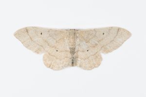


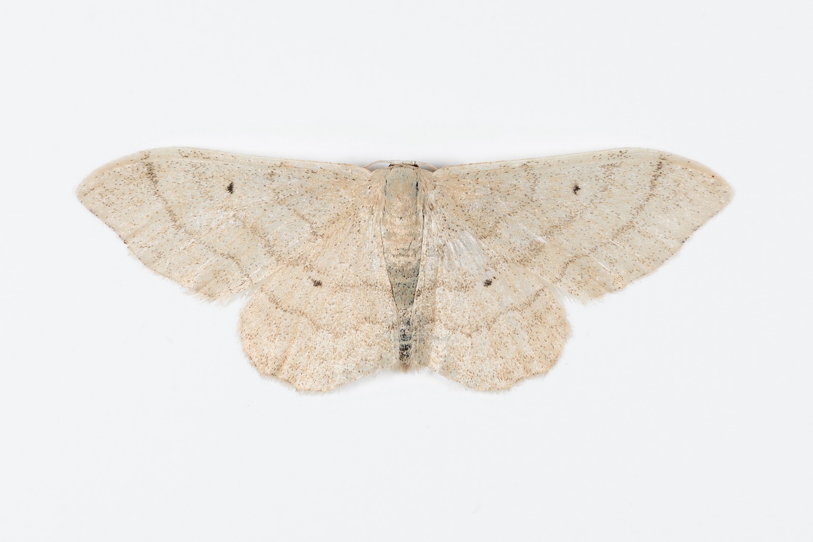
Image Gallery


Temporal Distribution Chart
Adults: (between 1951 - 2025)
Distribution Map for Idaea straminata
↳ from 2026+
↳ 17 from 2020 - 2025
↳ 33 from Before 2020
If the Map Layers function fails, just refresh the page and it should be OK after. Use the +- zoom on the top left, or on a tablet, use two fingers to zoom. Remember, the last layer you ticked is the one which displays the popup information - they sit on top of each other - de-select then re-select, to see the popup values.
Bedrock Geology ** indirectly affects moth distribution by influencing the type of habitat and food plants available in an area. In turn, this may affect the types of moths that can thrive, or where they can most likely be found.
NBN Atlas UK Distribution for – Idaea straminata
⚠️ Please wait for the map to load fully – do not click the link shown.
Note – the NBN Atlas datasets are listed in the map below and vary in their currency (uptodateness) – however,
the map does give a general indication of the moth's distribution across the UK.
Monthly Records By Year:
Idaea straminata
( data includes both Larvae and Adult Stages )
Monthly Counts By Year:
Idaea straminata
( data is based on 'Adult' stage records only )
First/Last Recorded Dates: Idaea straminata
Adult-only & Anything [Larvae, Pupae, Adult, Mines]
Shading shows moth presence between dates
Click the colour discs below to Select/De-select as Required
Recordings By Year: Idaea straminata
( All data includes both Larvae and Adult Stages )
Annual Growth Rate (AGR): Idaea straminata
AGR: 0% | Total % Change: 0%
Hectad (10kmx10km) Coverage: Idaea straminata
( data includes both Larvae and Adult Stages )
Flight Periods – Indicative –vs– Recorded Data
Idaea straminata
Idaea straminata
Flight Period chart – the grey hatched area above, which can cross one or more months, pictorially represents the best guess we have for this moth's flight periods [month/s]. The coloured lines represent the actual months seen in flight, from site observation records received between 2020-2026.
Records Behind the Map and Charts - Idaea straminata – 50 records available
Listed by Year - descending - scroll across to see all table columns
| Site Name | Tetrad | Date | Count | Stage | Recorder | Source | RecordKey |
|---|---|---|---|---|---|---|---|
| Longdendale, Torside Clough, Crags at m | SK09T | 22/07/2025 | 1 | adult | Heintzen, Christian | vc57_irecords_extract | iBRC43980558 |
| Birch Vale | SK08I | 05/07/2025 | 1 | adult | Hewitt, Jane | vc57_irecords_extract | iBRC47544635 |
| Markham Vale South Tip | SK47K | 12/07/2023 | 2 | adult | Morris, Sid | vc57_irecords_extract | iBRC31570780 |
| Longdendale, Wildboar Clough | SK09U | 07/07/2023 | 2 | adult | Heintzen, Christian | vc57_irecords_extract | iBRC36336604 |
| Ninelands Road | SK28F | 07/07/2023 | 1 | adult | Blues, Clare | vc57_irecords_extract | iBRC31413003 |
| Hathersage, Derbyshire, UK | SK28F | 07/07/2023 | 1 | adult | Miles, Claire | vc57_irecords_extract | iBRC31477157 |
| Longdendale, Long Gutter Edge Oaks | SK09U | 28/06/2023 | 9 | adult | Heintzen, Christian | vc57_irecords_extract | iBRC36336448 |
| Hathersage | SK28F | 28/06/2023 | 1 | adult | Kydd, Alan | vc57_irecords_extract | iBRC39080243 |
| Garden, Walton | SK36U | 30/07/2022 | 1 | adult | Palethorpe, Amanda | vc57_irecords_extract | iBRC41046964 |
| Ninelands Road | SK28F | 29/07/2022 | 1 | adult | Blues, Clare | vc57_irecords_extract | iBRC27389133 |
| Garden, Walton | SK36U | 19/07/2022 | 3 | adult | Palethorpe, Amanda | vc57_irecords_extract | iBRC41046935 |
| Staveley Derbyshire | SK47H | 14/07/2022 | 1 | adult | Morris, Sid | vc57_irecords_extract | iBRC26903923 |
| Garden, Walton | SK36U | 13/07/2022 | 1 | adult | Palethorpe, Amanda | vc57_irecords_extract | iBRC41046888 |
| Ninelands Road | SK28F | 31/07/2021 | 1 | adult | Blues, Clare | vc57_irecords_extract | iBRC27391156 |
| Hathersage, Derbyshire, UK | SK28F | 26/07/2021 | 1 | adult | Miles, Claire | vc57_irecords_extract | iBRC29829077 |
| Ninelands Road | SK28F | 18/07/2021 | 1 | adult | Blues, Clare | vc57_irecords_extract | iBRC27391874 |
| Hathersage, Derbyshire, UK | SK28F | 09/07/2021 | 1 | adult | Miles, Claire | vc57_irecords_extract | iBRC29738291 |
| Hathersage, Derbyshire, UK | SK28F | 25/07/2019 | 1 | adult | Miles, Claire | vc57_irecords_extract | iBRC12494139 |
| Pleasley Pit CP, Pleasley | SK46X | 25/07/2019 | 1 | Adult | B.J.N. Hill | vc57_danes_bc_data | LC000334001WQGSM |
| Hathersage, Derbyshire, UK | SK28F | 15/07/2019 | 1 | adult | Miles, Claire | vc57_irecords_extract | iBRC12533266 |
| Hathersage, Derbyshire, UK | SK28F | 07/07/2019 | 1 | adult | Miles, Claire | vc57_irecords_extract | iBRC12545701 |
| Pleasley Pit CP, Pleasley | SK46X | 06/08/2018 | 1 | Adult | B.J.N. Hill | vc57_danes_bc_data | LC000334001WPU84 |
| Welbeck Drive, Wingerworth | SK36T | 27/07/2018 | 1 | Adult | B.J.N. Hill | vc57_danes_bc_data | LC000334001WPRAV |
| Birch Vale | SK08I | 30/06/2018 | 1 | adult | Hewitt, Jane | vc57_irecords_extract | iBRC40106379 |
| Belper | SK34U | 29/06/2018 | 1 | adult | Evans, Dave | vc57_irecords_extract | iBRC38610128 |
| Birch Barn, New Mills Rd, Birch Vale | SK08I | 16/08/2015 | 1 | Adult | VC57 Derbyshire Recorder | vc57_danes_bc_data | LC000334001OLF7M |
| biggib dale biggin | SK15P | 31/07/2014 | 1 | adult | adrian gardiner | vc57_irecords_extract | iBRC7033231 |
| biggin dale | SK15P | 01/07/2014 | 1 | adult | adrian gardiner | vc57_irecords_extract | iBRC7162671 |
| Cross Green Cottages,Flint Lane,South Darley | SK26Q | 26/08/2013 | 1 | Adult | R. Hawksworth | vc57_danes_bc_data | LC000334001OKBQH |
| The Hollies,Station Rd,Darley Dale | SK26R | 15/07/2012 | 1 | Adult | Roddis, Simon | vc57_danes_bc_data | LC000334001OK9BL |
| Elgar Drive,Sawley,Long Eaton | SK43R | 07/07/2011 | 1 | Adult | A. Braddock | vc57_danes_bc_data | LC000334001OK6RY |
| The Hollies,Station Rd,Darley Dale | SK26R | 31/07/2010 | 1 | Adult | Roddis, Simon | vc57_danes_bc_data | LC000334001OKW8W |
| Dronfield Woodhouse | SK37J | 03/07/2010 | 1 | adult | Williamson, Andy | vc57_irecords_extract | iBRC45361747 |
| Calke Park Ticknall Lime Yards | SK32R | 22/07/2007 | 3 | adult | Finch, Graham Leonard | vc57_irecords_extract | iBRC35105940 |
| Ticknall Limeyards,Ticknall | SK32R | 22/07/2007 | 3 | Adult | Finch, Graham Leonard | vc57_danes_bc_data | LC000334001OJJ45 |
| Chase Cliffe Lodge, Crich, Ambergate | SK35L | 22/07/2003 | 1 | Adult | VC57 Derbyshire Recorder | vc57_danes_bc_data | LC000334001OJ3Z1 |
| School Close,Parkway Gardens,Darley Dale | SK26R | 04/08/2001 | 1 | Adult | A. Butler | vc57_danes_bc_data | LC000334001OJ2CB |
| Woodlands, Combs, Chapel en le Frith | SK07P | 11/07/1992 | 1 | Adult | S.G. Price | vc57_danes_bc_data | LC000334001OI1HI |
| Woodlands, Combs, Chapel en le Frith | SK07P | 13/07/1991 | 1 | Adult | S.G. Price | vc57_danes_bc_data | LC000334001OHL7M |
| Deerlands Rd, Ashgate, Chesterfield | SK37K | 02/08/1990 | 1 | Adult | VC57 Derbyshire Recorder | vc57_danes_bc_data | LC000334001OIURJ |
| Deerlands Rd, Ashgate, Chesterfield | SK37K | 02/08/1990 | 1 | Adult | B. Elliott | vc57_danes_bc_data | LC000334001WONB4 |
| Skinner St, Creswell, Worksop | SK57H | 04/08/1988 | 1 | Adult | VC57 Derbyshire Recorder | vc57_danes_bc_data | LC000334001OI07Y |
| Skinner St, Creswell, Worksop | SK57H | 05/07/1983 | 1 | Adult | VC57 Derbyshire Recorder | vc57_danes_bc_data | LC000334001OIPSQ |
| Barnard Ave, Coal Aston | SK37U | 01/01/1981 | 1 | Adult | VC57 Derbyshire Recorder | vc57_danes_bc_data | LC000334001OINEP |
| Barnard Ave, Coal Aston | SK37U | 01/01/1981 | 1 | Adult | A. Mclean | vc57_danes_bc_data | LC000334001WPWTR |
| Church St,Holloway,Matlock | SK35I | 10/07/1979 | 2 | Adult | F. Harrison | vc57_danes_bc_data | LC000334001OHXHY |
| Whitwell Wood, Whitwell, Worksop (site not precise) | SK57J | 09/07/1977 | 1 | Adult | F. Harrison | vc57_danes_bc_data | LC000334001OHFZW |
| John St, Clay Cross (garden site assumed) | SK36W | 18/08/1962 | 2 | Adult | VC57 Derbyshire Recorder | vc57_danes_bc_data | LC000334001OHVTG |
| John St, Clay Cross (garden site assumed) | SK36W | 13/07/1960 | 1 | Adult | VC57 Derbyshire Recorder | vc57_danes_bc_data | LC000334001OHVQM |
| Froggatt Edge, Calver (site not precise) | SK27N | 18/08/1951 | 1 | Adult | VC57 Derbyshire Recorder | vc57_danes_bc_data | LC000334001OJHN6 |