 – click for General Verification Guidelines | – click for Specific Verification Guidelines
  – Uncertain/Unknown – Insufficient Data
  – Leaf-miner
Confusion Species: P.klemannella, P.froelichiella
Mine Period Additional: None.
Mine ID Difficulty:
Mine Type/s: Not Recorded
Mine Feeding Method/s: Not Recorded
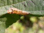
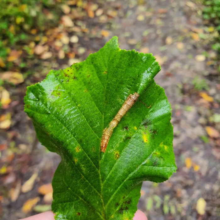
Mine Comment: The larvae mine the leaves of Hazel creating a long, lower-surface tentiform mine in a small rectangular mine on the underside of the leaf between the leaf veins. Strongly arched and the upper surface of the leaf often shows a mottled brown pattern, with a central green patch
Martin C. Harvey© / Buxton – Steve Orridge© / Wyver Lane Aug & Oct 2025 – Dave Evans©


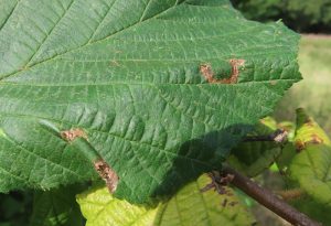
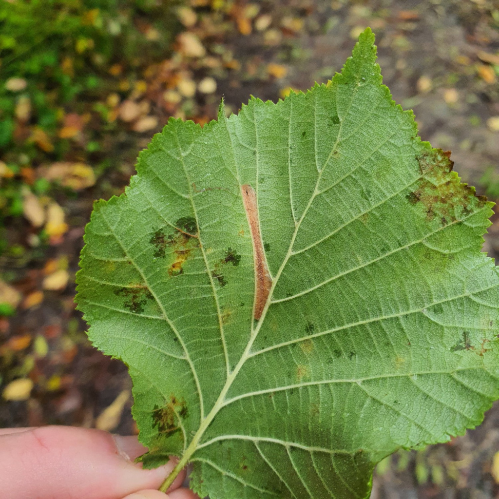


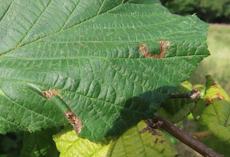
Image Gallery

Temporal Distribution Chart
Adults: (between 2016 - 2016) | Immatures: (between 2001 - 2025)
Distribution Map for Phyllonorycter nicellii
↳ from 2026+
↳ 12 from 2020 - 2025
↳ 27 from Before 2020
If the Map Layers function fails, just refresh the page and it should be OK after. Use the +- zoom on the top left, or on a tablet, use two fingers to zoom. Remember, the last layer you ticked is the one which displays the popup information - they sit on top of each other - de-select then re-select, to see the popup values.
Bedrock Geology ** indirectly affects moth distribution by influencing the type of habitat and food plants available in an area. In turn, this may affect the types of moths that can thrive, or where they can most likely be found.
NBN Atlas UK Distribution for – Phyllonorycter nicellii
⚠️ Please wait for the map to load fully – do not click the link shown.
Note – the NBN Atlas datasets are listed in the map below and vary in their currency (uptodateness) – however,
the map does give a general indication of the moth's distribution across the UK.
Monthly Records By Year:
Phyllonorycter nicellii
( data includes both Larvae and Adult Stages )
Monthly Counts By Year:
Phyllonorycter nicellii
( data is based on 'Adult' stage records only )
First/Last Recorded Dates: Phyllonorycter nicellii
Adult-only & Anything [Larvae, Pupae, Adult, Mines]
Shading shows moth presence between dates
Click the colour discs below to Select/De-select as Required
Recordings By Year: Phyllonorycter nicellii
( All data includes both Larvae and Adult Stages )
Annual Growth Rate (AGR): Phyllonorycter nicellii
AGR: 4.68% | Total % Change: 200%
Hectad (10kmx10km) Coverage: Phyllonorycter nicellii
( data includes both Larvae and Adult Stages )
Flight Periods – Indicative –vs– Recorded Data
Phyllonorycter nicellii
Phyllonorycter nicellii
Flight Period chart – the grey hatched area above, which can cross one or more months, pictorially represents the best guess we have for this moth's flight periods [month/s]. The coloured lines represent the actual months seen in flight, from site observation records received between 2020-2026.
Mine Periods – Indicative –vs– Recorded Data
Phyllonorycter nicellii
Phyllonorycter nicellii
( data includes both Larvae and Adult Stages )
Mine Period chart – the grey hatched area above, which can cross one or more months, pictorially represents the best guess we have for this moth's mine periods [month/s]. The coloured lines represent the actual months seen mining, from site observation records received between 2020-2026.
Records Behind the Map and Charts - Phyllonorycter nicellii – 39 records available
Listed by Year - descending - scroll across to see all table columns
| Site Name | Tetrad | Date | Count | Stage | Recorder | Source | RecordKey |
|---|---|---|---|---|---|---|---|
| Harry's Wood, Smisby | SK32K | 13/10/2025 | 1 | Mine | Finch, Graham Leonard | vc57_irecords_extract | iBRC50352002 |
| Darwin Forest | SK26X | 04/10/2025 | 4 | mine (empty) | Evans, Dave | vc57_irecords_extract | iBRC45786881 |
| DWT Wyver Lane | SK34P | 13/08/2025 | 6 | mine (empty) | Evans, Dave | vc57_irecords_extract | iBRC44440769 |
| DWT Wyver Lane | SK34P | 06/08/2025 | 1 | mine (empty) | Evans, Dave | vc57_irecords_extract | iBRC44213587 |
| Pottery Wood | SK32G | 05/11/2024 | 1 | Mine | Finch, Graham Leonard | vc57_irecords_extract | iBRC41038960 |
| Burton upon Trent | SK32P | 05/11/2024 | 1 | Mine | Finch, Graham Leonard | vc57_irecords_extract | iBRC41038914 |
| Lathkill Dale | SK16X | 16/10/2024 | 1 | mine | Harvey, Martin C. | vc57_irecords_extract | iBRC38901109 |
| Poppy Wood | SK32S | 22/11/2023 | 1 | Mine | Finch, Graham Leonard | vc57_irecords_extract | iBRC35107069 |
| Calke Park | SK32R | 01/10/2023 | 1 | Mine | Finch, Graham Leonard | vc57_irecords_extract | iBRC35105549 |
| Carver's Rocks | SK32G | 30/09/2023 | 1 | Mine | Finch, Graham Leonard | vc57_irecords_extract | iBRC35106091 |
| Carver's Rocks | SK32H | 21/09/2023 | 1 | Mine | Finch, Graham Leonard | vc57_irecords_extract | iBRC35106116 |
| Allestree Park | SK34K | 25/09/2022 | 1 | Mine | Finch, Graham Leonard | vc57_irecords_extract | iBRC35105371 |
| Grange Wood | SK21S | 13/09/2018 | 1 | Mine | Finch, Graham Leonard | vc57_irecords_extract | iBRC35106445 |
| Coombs Dale, Calver | SK27H | 30/07/2016 | 1 | Adult | Watchorn, Andrew | vc57_irecords_extract | iBRC3782467 |
| nr Smith's Gorse, Hartshorne, Swadlincote | SK32G | 15/08/2014 | 1 | Larval Mine | Dave Budworth | vc57_danes_bc_data | LC000334001COYYA |
| Robin Wood, Ticknall | SK32M | 01/09/2013 | 1 | Larval Mine | Dave Budworth | vc57_danes_bc_data | LC000334001COYTX |
| Millers Dale | SK17G | 03/09/2011 | 1 | Larval Mine | S.H. Hind | vc57_danes_bc_data | LC000334001CP7LO |
| Thorpe, Ashbourne DE, UK | SK15K | 13/10/2010 | 1 | Larva | Orridge, Steve | vc57_irecords_extract | iBRC23128101 |
| Thorpe, Dovedale | SK15K | 13/10/2010 | 1 | Larval Mine | S.A. Orridge;S.H. Hind | vc57_danes_bc_data | LC000334001CP6QQ |
| Ashford in the Water | SK16Z | 22/09/2010 | 1 | Larval Mine | S.A. Orridge;S.H. Hind | vc57_danes_bc_data | LC000334001CP6OV |
| Ashford in the Water | SK16Z | 22/09/2010 | 1 | Larval Mine | S.A. Orridge;S.H. Hind | vc57_danes_bc_data | LC000334001CP6PJ |
| Bamford | SK28B | 21/09/2010 | 1 | Larval Mine | K. McCabe;S.H. Hind | vc57_danes_bc_data | LC000334001COTPV |
| Ladybower Resr | SK18U | 03/09/2010 | 1 | Larval Mine | S.H. Hind | vc57_danes_bc_data | LC000334001CP6L5 |
| Carvers Rocks, Hartshorne, Swadlincote | SK32G | 18/08/2010 | 1 | Larval Mine | Dave Budworth | vc57_danes_bc_data | LC000334001COTMY |
| Hopton Wood NR, Cromford | SK25T | 16/10/2009 | 1 | Larval Mine | Dave Budworth;S.A. Orridge;S.H. Hind | vc57_danes_bc_data | LC000334001COT0X |
| Cromford | SK25Y | 16/10/2009 | 1 | Larval Mine | Dave Budworth;S.A. Orridge;S.H. Hind | vc57_danes_bc_data | LC000334001CP564 |
| Linacre | SK37L | 13/10/2009 | 1 | Larval Mine | S.H. Hind | vc57_danes_bc_data | LC000334001CP559 |
| Coombs Dale,Stoney Middleton | SK27H | 12/10/2009 | 1 | Larval Mine | S.H. Hind | vc57_danes_bc_data | LC000334001COWZ3 |
| Coombs Dale,Stoney Middleton | SK27H | 12/10/2009 | 1 | Larval Mine | S.H. Hind | vc57_danes_bc_data | LC000334001CP541 |
| Hope | SK18R | 07/10/2009 | 1 | Larval Mine | S.H. Hind | vc57_danes_bc_data | LC000334001COSZJ |
| Tissington Trail, Ashbourne | SK14T | 01/10/2009 | 1 | Larval Mine | Dave Budworth;S.A. Orridge;S.H. Hind | vc57_danes_bc_data | LC000334001COWYU |
| Calke Park | SK32L | 25/10/2008 | 1 | Mine | Finch, Graham Leonard | vc57_irecords_extract | iBRC35105488 |
| Calke Park,Ticknall | SK32R | 25/10/2008 | 1 | Larval Mine | VC57 Derbyshire Recorder | vc57_danes_bc_data | LC000334001COSOL |
| Lathkill Dale,Bakewell | SK16Y | 19/09/2008 | 1 | Larval Mine | Dave Budworth;S.H. Hind | vc57_danes_bc_data | LC000334001CP4LN |
| Lathkill Dale,Bakewell | SK26D | 19/09/2008 | 1 | Larval Mine | Dave Budworth;S.H. Hind | vc57_danes_bc_data | LC000334001CP4LY |
| Monsall Trail, Buxton | SK17L | 14/09/2008 | 1 | Larval Mine | S.H. Hind | vc57_danes_bc_data | LC000334001COSNR |
| Carvers Rocks (sth Bridle Path), Hartshorne, Swadlincote | SK32G | 22/10/2007 | 1 | Larval Mine | Dave Budworth | vc57_danes_bc_data | LC000334001COSGT |
| Shallcross Wood, Goyt Valley, Whaley Bridge | SK07E | 26/09/2006 | 1 | Larval Mine | S.H. Hind | vc57_danes_bc_data | LC000334001CP9YC |
| Abbotsholme School, Rocester | SK13E | 04/10/2001 | 1 | Larval Mine | S.H. Hind | vc57_danes_bc_data | LC000334001COVGX |