
 – click for Adult Macro Verification Guidelines
 – Uncommon / Scarce
 – Day-flying
Forewing: 13-16mm
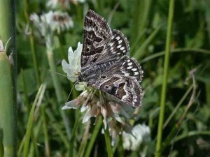


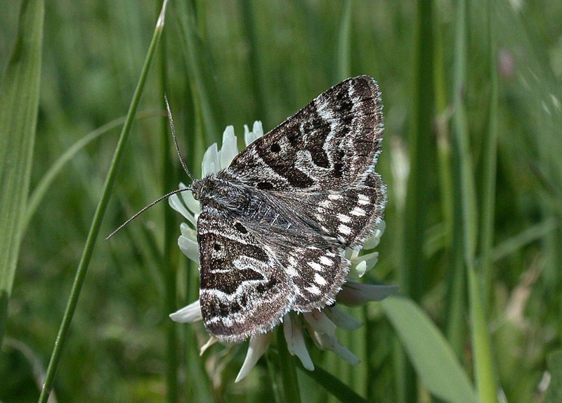
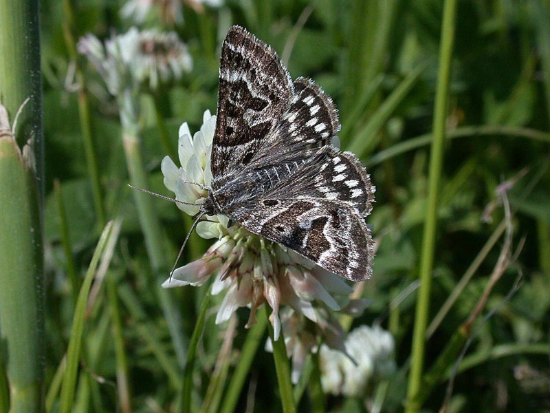
Image Gallery
Temporal Distribution Chart
Adults: (between 1952 - 2026) | Immatures: (between 2023 - 2023)
Distribution Map for Callistege mi
↳ 32 from 2026+
↳ 111 from 2020 - 2025
↳ 129 from Before 2020
If the Map Layers function fails, just refresh the page and it should be OK after. Use the +- zoom on the top left, or on a tablet, use two fingers to zoom. Remember, the last layer you ticked is the one which displays the popup information - they sit on top of each other - de-select then re-select, to see the popup values.
Bedrock Geology ** indirectly affects moth distribution by influencing the type of habitat and food plants available in an area. In turn, this may affect the types of moths that can thrive, or where they can most likely be found.
NBN Atlas UK Distribution for – Callistege mi
⚠️ Please wait for the map to load fully – do not click the link shown.
Note – the NBN Atlas datasets are listed in the map below and vary in their currency (uptodateness) – however,
the map does give a general indication of the moth's distribution across the UK.
Monthly Records By Year:
Callistege mi
( data includes both Larvae and Adult Stages )
Monthly Counts By Year:
Callistege mi
( data is based on 'Adult' stage records only )
First/Last Recorded Dates: Callistege mi
Adult-only & Anything [Larvae, Pupae, Adult, Mines]
Shading shows moth presence between dates
Click the colour discs below to Select/De-select as Required
Recordings By Year: Callistege mi
( All data includes both Larvae and Adult Stages )
Annual Growth Rate (AGR): Callistege mi
AGR: 1.34% | Total % Change: 37.5%
Hectad (10kmx10km) Coverage: Callistege mi
( data includes both Larvae and Adult Stages )
Flight Periods – Indicative –vs– Recorded Data
Callistege mi
Callistege mi
Flight Period chart – the grey hatched area above, which can cross one or more months, pictorially represents the best guess we have for this moth's flight periods [month/s]. The coloured lines represent the actual months seen in flight, from site observation records received between 2020-2026.
Records Behind the Map and Charts - Callistege mi – 272 records available
Listed by Year - descending - scroll across to see all table columns
| Site Name | Tetrad | Date | Count | Stage | Recorder | Source | RecordKey |
|---|---|---|---|---|---|---|---|
| Brailsford - S | SK24K | 18/06/2026 | 1 | Adult | Bryan, Alan | vc57_irecords_extract | iBRC53810804 |
| DWT Wyver Lane | SK34P | 09/06/2026 | 1 | adult | Evans, Dave | vc57_irecords_extract | iBRC53282339 |
| DWT Wyver Lane | SK34P | 09/06/2026 | 1 | adult | Evans, Dave | vc57_irecords_extract | iBRC53282787 |
| Kirk Langley, Derbyshire | SK33E | 06/06/2026 | 1 | adult | Plant, Stephen | vc57_irecords_extract | iBRC53282075 |
| Allestree, Derby | SK34K | 05/06/2026 | 1 | adult | Plant, Stephen | vc57_irecords_extract | iBRC53138933 |
| Toyota UK Burnaston Grid to Buildings - S | SK23V | 03/06/2026 | 2 | Adult | JORDAN HOLMES | vc57_irecords_extract | iBRC53500903 |
| Toyota UK Burnaston Grid to Buildings - S | SK23V | 03/06/2026 | 4 | Adult | JORDAN HOLMES | vc57_irecords_extract | iBRC53500904 |
| Toyota UK Burnaston Grid to Buildings - S | SK23V | 03/06/2026 | 1 | Adult | JORDAN HOLMES | vc57_irecords_extract | iBRC53500905 |
| Toyota UK Burnaston Grid to Buildings - S | SK23V | 03/06/2026 | 1 | Adult | JORDAN HOLMES | vc57_irecords_extract | iBRC53501042 |
| DWT Wyver Lane | SK34P | 02/06/2026 | 1 | adult | Evans, Dave | vc57_irecords_extract | iBRC53061435 |
| Belper Private Butterfly NR | SK34U | 02/06/2026 | 1 | Adult | Davidson, Nigel | vc57_irecords_extract | iBRC53034174 |
| DWT Wyver Lane | SK35K | 02/06/2026 | 1 | adult | Evans, Dave | vc57_irecords_extract | iBRC53061546 |
| Drakelow | SK21J | 30/05/2026 | 1 | adult | Williams, Michael | vc57_irecords_extract | iBRC53456196 |
| Markham Vale North Tip | SK47L | 30/05/2026 | 4 | adult | Radford, Mark | vc57_irecords_extract | iBRC52853038 |
| Derby Hills Quarry, Mercaston - S | SK24S | 28/05/2026 | 1 | Adult | Perry, Chris | vc57_irecords_extract | iBRC52741057 |
| Belper Private Butterfly NR | SK34U | 28/05/2026 | 1 | Adult | Davidson, Nigel | vc57_irecords_extract | iBRC52759152 |
| Toyota UK Burnaston Grid to Buildings - S | SK23V | 27/05/2026 | 1 | Adult | JORDAN HOLMES | vc57_irecords_extract | iBRC53177304 |
| Toyota UK Burnaston Grid to Buildings - S | SK23V | 27/05/2026 | 1 | Adult | JORDAN HOLMES | vc57_irecords_extract | iBRC53177305 |
| Toyota UK Burnaston Grid to Buildings - S | SK23V | 27/05/2026 | 1 | Adult | JORDAN HOLMES | vc57_irecords_extract | iBRC53177306 |
| Toyota UK Burnaston Grid to Buildings - S | SK23V | 27/05/2026 | 3 | Adult | JORDAN HOLMES | vc57_irecords_extract | iBRC53177311 |
| DWT Wyver Lane | SK34P | 26/05/2026 | 2 | adult | Evans, Dave | vc57_irecords_extract | iBRC52681052 |
| Westhouses. | SK45I | 26/05/2026 | 2 | adult | Bradley, Jonathan | vc57_irecords_extract | iBRC52935703 |
| Cressbrook Dale top end | SK17S | 25/05/2026 | 1 | adult | Whiteley, Derek | vc57_irecords_extract | iBRC52968748 |
| Derby Hills Quarry, Mercaston - S | SK24S | 25/05/2026 | 1 | Adult | Perry, Chris | vc57_irecords_extract | iBRC52624183 |
| Holloway | SK35I | 25/05/2026 | 1 | adult | Pritchard, Alison | vc57_irecords_extract | iBRC53024779 |
| . | SK33Z | 24/05/2026 | 1 | Adult | Orpe, Ken | vc57_irecords_extract | iBRC53144383 |
| Aston Brickyard Plantation - S | SK43A | 24/05/2026 | 1 | Adult | Orpe, Ken | vc57_irecords_extract | iBRC53144324 |
| Belper Private Butterfly NR | SK34U | 23/05/2026 | 2 | Adult | Davidson, Nigel | vc57_irecords_extract | iBRC52540323 |
| Fallcliff Wood | SK27J | 22/05/2026 | 1 | adult | Whiteley, Derek | vc57_irecords_extract | iBRC53061851 |
| Markham Vale | SK47K | 22/05/2026 | 1 | adult | Penson, Melanie | vc57_irecords_extract | iBRC52532884 |
| Clover Close Meadows Elvaston - S | SK43B | 07/05/2026 | 1 | Adult | Breakwell, Joan and Fran Smith | vc57_irecords_extract | iBRC52217866 |
| Markham Vale Derbyshire- | SK47L | 06/05/2026 | 1 | adult | Morris, Sid | vc57_irecords_extract | iBRC52030674 |
| Millers Dale Quarry - S | SK17L | 21/06/2025 | 2 | Adult | Faulkner, Peter | vc57_irecords_extract | iBRC42506849 |
| Belper Private Butterfly NR | SK34U | 13/06/2025 | 1 | Adult | Davidson, Nigel | vc57_irecords_extract | iBRC42257532 |
| Beckside Farm | SK24F | 08/06/2025 | 1 | Adult | Beverley, Michele | vc57_irecords_extract | iBRC45338116 |
| Holloway | SK35I | 06/06/2025 | 1 | Adult | Pritchard, Alison | vc57_irecords_extract | iBRC42101183 |
| Holloway | SK35I | 31/05/2025 | 1 | Adult | Pritchard, Alison | vc57_irecords_extract | iBRC41973849 |
| Deep Dale, Derbyshire, UK | SK17Q | 25/05/2025 | 1 | Adult | Cocker, Mark | vc57_irecords_extract | iBRC41804029 |
| Foremark Res. | SK32G | 23/05/2025 | 1 | Adult | Williams, Michael | vc57_irecords_extract | iBRC41772506 |
| Private butterfly NR Belper | SK34U | 21/05/2025 | 1 | Adult | Davidson, Nigel | vc57_irecords_extract | iBRC41725201 |
| Holloway | SK35I | 19/05/2025 | 1 | Adult | Pritchard, Alison | vc57_irecords_extract | iBRC41792907 |
| Drakelow | SK21J | 17/05/2025 | 1 | Adult | Williams, Michael | vc57_irecords_extract | iBRC41705560 |
| Drakelow | SK21J | 17/05/2025 | 1 | Adult | Williams, Michael | vc57_irecords_extract | iBRC41705796 |
| Drakelow | SK21J | 16/05/2025 | 1 | Adult | Williams, Michael | vc57_irecords_extract | iBRC41638397 |
| Private butterfly NR Belper | SK34U | 16/05/2025 | 3 | Adult | Davidson, Nigel | vc57_irecords_extract | iBRC41611804 |
| Markham Vale South Tip , Derbyshire | SK47K | 16/05/2025 | 1 | Adult | Morris, Sid | vc57_irecords_extract | iBRC41631324 |
| Private butterfly NR Belper | SK34U | 13/05/2025 | 1 | Adult | Davidson, Nigel | vc57_irecords_extract | iBRC41545009 |
| Toyota UK Burnaston Meadow - S | SK23V | 10/05/2025 | 1 | Adult | Lawrence, Kelvin | vc57_irecords_extract | iBRC41750705 |
| Crich Chase | SK35L | 10/05/2025 | 1 | Adult | Pritchard, Alison | vc57_irecords_extract | iBRC41582721 |
| Markham Vale South Tip | SK47K | 10/05/2025 | 2 | Adult | Radford, Mark | vc57_irecords_extract | iBRC41486325 |
| Monsal Dale | SK17Q | 06/05/2025 | 1 | Adult | White, Ian M | vc57_irecords_extract | iBRC41410151 |
| Holloway | SK35I | 02/05/2025 | 2 | Adult | Pritchard, Alison | vc57_irecords_extract | iBRC41371677 |
| Holloway | SK35I | 29/04/2025 | 1 | Adult | Pritchard, Alison | vc57_irecords_extract | iBRC41254969 |
| Holloway Fields - S | SK35I | 29/04/2025 | 1 | Adult | Pritchard, Alison | vc57_irecords_extract | iBRC41370524 |
| Ingles Hill Woodland - S | SK31P | 26/07/2024 | 1 | Adult | Tyson, Oliver | vc57_irecords_extract | iBRC37359995 |
| Cressbrook | SK17R | 20/06/2024 | 1 | Adult | Hewitt, Jane | vc57_irecords_extract | iBRC39762834 |
| National Stone Centre, Matlock DELS, UK | SK25X | 17/06/2024 | 1 | Adult | Nadine | vc57_irecords_extract | iBRC36480955 |
| Holloway Fields - S | SK35I | 08/06/2024 | 1 | Adult | Pritchard, Alison | vc57_irecords_extract | iBRC36340346 |
| Hilton Gravel Pits NR - S | SK23K | 01/06/2024 | 1 | Adult | Lawrence, Kelvin | vc57_irecords_extract | iBRC36370460 |
| Salter Wood Denby - S | SK34Z | 01/06/2024 | 2 | Adult | Rogers, Jane | vc57_irecords_extract | iBRC36206676 |
| Hilton Valley Park - S | SK22P | 27/05/2024 | 1 | Adult | Wayne Cooper | vc57_irecords_extract | iBRC36176454 |
| Kedleston Park - S | SK34A | 25/05/2024 | 1 | Adult | Nick brown | vc57_irecords_extract | iBRC36108091 |
| Holloway, Matlock | SK35I | 20/05/2024 | 1 | Adult | Pritchard, Alison | vc57_irecords_extract | iBRC36027076 |
| Hay Dale | SK17I | 19/05/2024 | 1 | Adult | White, Ian M | vc57_irecords_extract | iBRC36004044 |
| Holloway, Matlock | SK35I | 18/05/2024 | 1 | Adult | Pritchard, Alison | vc57_irecords_extract | iBRC35980616 |
| Bennerley Lodge and Stensons Lock | SK44R | 15/05/2024 | 1 | Adult | Jones, Dave | vc57_irecords_extract | iBRC35948261 |
| Lightwood | SK07M | 25/08/2023 | 1 | larva | Orridge, Steve | vc57_irecords_extract | iBRC35077349 |
| Orchid Wood | SK43L | 14/08/2023 | 1 | larva | Bryce, Marion | vc57_irecords_extract | iBRC32417277 |
| Rose End Meadows NR | SK25Y | 30/06/2023 | 1 | Adult | Ashton, Clive | vc57_irecords_extract | iBRC34568938 |
| Landal Darwin Forest CP | SK36C | 29/06/2023 | 1 | Adult | Evans, Dave | vc57_irecords_extract | iBRC35307687 |
| Bennerley Lodge and Stensons Lock | SK44R | 28/06/2023 | 2 | Adult | Jones, Dave | vc57_irecords_extract | iBRC31171278 |
| Bennerley Lodge and Stensons Lock | SK44R | 25/06/2023 | 1 | Adult | Jones, Dave | vc57_irecords_extract | iBRC31091857 |
| DWT Wyver Lane | SK34P | 15/06/2023 | 1 | Adult | Evans, Dave | vc57_irecords_extract | iBRC35307957 |
| Holloway, Matlock | SK35I | 11/06/2023 | 1 | Adult | Pritchard, Alison | vc57_irecords_extract | iBRC35453907 |
| Dore churchyard | SK38A | 10/06/2023 | 1 | Adult | Keywood, Ben | vc57_irecords_extract | iBRC33407687 |
| Slaley, Matlock DEBB, UK | SK25T | 09/06/2023 | 1 | Adult | nadinesnowsill | vc57_irecords_extract | iBRC30777277 |
| Longstone Edge | SK27B | 09/06/2023 | 2 | Adult | BISSITT, ANDREW | vc57_irecords_extract | iBRC31137364 |
| Holloway, Matlock | SK35I | 09/06/2023 | 1 | Adult | Pritchard, Alison | vc57_irecords_extract | iBRC35453887 |
| Holloway Fields - S | SK35I | 09/06/2023 | 1 | Adult | Pritchard, Alison | vc57_irecords_extract | iBRC45134991 |
| DWT Wyver Lane | SK34P | 07/06/2023 | 1 | Adult | Evans, Dave | vc57_irecords_extract | iBRC35307845 |
| Clover Close Meadows Elvaston - S | SK43B | 05/06/2023 | 1 | Adult | Bryce, Marion | vc57_irecords_extract | iBRC30679726 |
| Elvaston Clover Close | SK43B | 05/06/2023 | 1 | Adult | Bryce, Marion | vc57_irecords_extract | iBRC30682544 |
| Clover Close, Elvaston | SK43B | 05/06/2023 | 2 | Adult | Bryce, Marion | vc57_irecords_extract | iBRC36433527 |
| LUDWORTH MOOR | SJ99V | 04/06/2023 | 3 | Adult | BISSITT, ANDREW | vc57_irecords_extract | iBRC31092379 |
| Hartington Meadows | SK16K | 04/06/2023 | 1 | Adult | Higginson-Tranter, Dave | vc57_irecords_extract | iBRC30671175 |
| Ingles Hill Woodland - S | SK31P | 04/06/2023 | 1 | Adult | Brook, Stephen | vc57_irecords_extract | iBRC33530460 |
| Markham Vale Derbyshire | SK47A | 02/06/2023 | 1 | Adult | Radford, Mark | vc57_irecords_extract | iBRC30638966 |
| Ashbourne Airfield | SK24C | 29/05/2023 | 2 | Adult | Goddard, Sam | vc57_irecords_extract | iBRC30557289 |
| Chinley Head | SK08M | 27/05/2023 | 1 | Adult | Hewitt, Jane | vc57_irecords_extract | iBRC34361424 |
| hopton quarry | SK25T | 27/05/2023 | 1 | Adult | Bryce, Marion | vc57_irecords_extract | iBRC30529526 |
| Clover Close Meadows Elvaston - S | SK43B | 26/05/2023 | 1 | Adult | Bryce, Marion | vc57_irecords_extract | iBRC30513364 |
| Clover Close Meadows Elvaston - S | SK43B | 26/05/2023 | 1 | Adult | Bryce, Marion | vc57_irecords_extract | iBRC30513369 |
| Clover Close Meadows Elvaston - S | SK43B | 26/05/2023 | 1 | Adult | Bryce, Marion | vc57_irecords_extract | iBRC30513401 |
| Straw's Bridge LNR | SK44K | 23/05/2023 | 1 | Adult | Bryce, Marion | vc57_irecords_extract | iBRC30469210 |
| Derbyshire, UK | SK17I | 20/05/2023 | 1 | Adult | White, Ian M | vc57_irecords_extract | iBRC30425286 |
| Chee Dale NR - S | SK17G | 14/05/2023 | 1 | Adult | Coupland, John | vc57_irecords_extract | iBRC30392300 |
| Peak District National Park, Buxton, England, GB | SK16K | 22/06/2022 | 1 | Adult | musci | vc57_irecords_extract | iBRC25932353 |
| Yew Tree Cottage, Arter Hill, Bonsall, Matlock DEAZ, UK | SK25U | 16/06/2022 | 1 | Adult | nadinesnowsill | vc57_irecords_extract | iBRC25829590 |
| Millers Dale Quarry - S | SK17L | 11/06/2022 | 1 | Adult | Faulkner, Peter | vc57_irecords_extract | iBRC25740054 |
| Not given | SK16S | 10/06/2022 | 1 | Adult | Faulkner, Peter | vc57_irecords_extract | iBRC25726254 |
| Derbyshire, UK | SK07K | 09/06/2022 | 1 | Adult | White, Ian M | vc57_irecords_extract | iBRC25705381 |
| Graphite Way, Glossop, England, GB | SK09D | 04/06/2022 | 1 | Adult | willunders50 | vc57_irecords_extract | iBRC46273190 |
| Derbyshire, UK | SK16Z | 04/06/2022 | 1 | Adult | Mortin, Jon | vc57_irecords_extract | iBRC25635317 |
| Clough Wood (Darley Bridge) - S | SK26K | 03/06/2022 | 1 | Adult | Faulkner, Peter | vc57_irecords_extract | iBRC25700368 |
| LUDWORTH MOOR | SJ99V | 02/06/2022 | 1 | Adult | BISSITT, ANDREW | vc57_irecords_extract | iBRC25685585 |
| West Hallam Ash Tip, Derbys | SK44L | 02/06/2022 | 1 | Adult | Penson, Melanie | vc57_irecords_extract | iBRC25626430 |
| Hogshaw, Buxton | SK07S | 30/05/2022 | 1 | Adult | Mortin, Jon | vc57_irecords_extract | iBRC29192833 |
| Black Edge | SK07T | 18/05/2022 | 1 | Adult | Orridge, Steve | vc57_irecords_extract | iBRC35089250 |
| Derbyshire, UK | SK07W | 18/05/2022 | 1 | Adult | White, Ian M | vc57_irecords_extract | iBRC25411805 |
| Loscoe, Heanor, UK | SK44I | 18/05/2022 | 1 | Adult | lucyb_ | vc57_irecords_extract | iBRC25439865 |
| Millers Dale Quarry - S | SK17L | 14/05/2022 | 1 | Adult | Faulkner, Peter | vc57_irecords_extract | iBRC25370408 |
| Not given | SK16S | 13/05/2022 | 1 | Adult | Faulkner, Peter | vc57_irecords_extract | iBRC25383497 |
| Glossop SKPQ, UK | SK09S | 29/06/2021 | 1 | Adult | halimione | vc57_irecords_extract | iBRC22765005 |
| BROWN LOW | SJ99V | 22/06/2021 | 1 | Adult | BISSITT, ANDREW | vc57_irecords_extract | iBRC20853359 |
| Ilkeston, Derbyshire | SK44L | 16/06/2021 | 1 | Adult | Plant, Stephen | vc57_irecords_extract | iBRC46654475 |
| LUDWORTH PLANTATION | SJ99V | 13/06/2021 | 1 | Adult | BISSITT, ANDREW | vc57_irecords_extract | iBRC20781007 |
| Ferneydale (Grazed) | SK07Q | 13/06/2021 | 1 | Adult | Wakefield, Rowan | vc57_irecords_extract | iBRC43076672 |
| Blackwell Trail:Blackwell | SK45J | 13/06/2021 | 1 | Adult | Mahadevan, Nikki | vc57_irecords_extract | iBRC34958069 |
| Forbes Hole LNR | SK43W | 11/06/2021 | 1 | Adult | Bryce, Marion | vc57_irecords_extract | iBRC20638979 |
| Buxton SK, UK | SK07L | 08/06/2021 | 1 | Adult | Mortin, Jon | vc57_irecords_extract | iBRC22718877 |
| St James Church, Harpur | SK07Q | 08/06/2021 | 1 | Adult | Mortin, Jon | vc57_irecords_extract | iBRC20615464 |
| Drakelow, Derbys. | SK21J | 08/06/2021 | 1 | Adult | Williams, Michael | vc57_irecords_extract | iBRC38494178 |
| Drakelow, Derbys. | SK22F | 08/06/2021 | 1 | Adult | Williams, Michael | vc57_irecords_extract | iBRC38494176 |
| Drakelow, Derbys. | SK21J | 05/06/2021 | 3 | Adult | Williams, Michael | vc57_irecords_extract | iBRC38494173 |
| Derbyshire, UK | SK17I | 04/06/2021 | 1 | Adult | White, Ian M | vc57_irecords_extract | iBRC29264386 |
| Burbage Moor | SK28Q | 02/06/2021 | 1 | Adult | Allnatt, Gina | vc57_irecords_extract | iBRC20549911 |
| Burbage Moor | SK28Q | 02/06/2021 | 1 | Adult | Allnatt, Gina | vc57_irecords_extract | iBRC20549966 |
| Drakelow, Derbys. | SK21J | 01/06/2021 | 4 | Adult | Williams, Michael | vc57_irecords_extract | iBRC38494029 |
| Drakelow, Derbys. | SK22F | 01/06/2021 | 1 | Adult | Williams, Michael | vc57_irecords_extract | iBRC38494027 |
| Drakelow, Derbys. | SK22F | 30/05/2021 | 1 | Adult | Williams, Michael | vc57_irecords_extract | iBRC38493996 |
| Haddon Park | SK26I | 30/05/2021 | 1 | Adult | Whiteley, Derek | vc57_irecords_extract | iBRC22223354 |
| Drakelow, Derbys. | SK21J | 29/05/2021 | 2 | Adult | Williams, Michael | vc57_irecords_extract | iBRC38493991 |
| Drakelow, Derbys. | SK22F | 27/05/2021 | 1 | Adult | Williams, Michael | vc57_irecords_extract | iBRC38493955 |
| Heanor and Loscoe, UK | SK44I | 31/05/2020 | 1 | Adult | lucyb_ | vc57_irecords_extract | iBRC22262147 |
| Lightwood, Buxton | SK07M | 30/05/2020 | 1 | Adult | White, Ian M | vc57_irecords_extract | iBRC28188663 |
| LUDWORTH MOOR | SJ99V | 29/05/2020 | 1 | Adult | BISSITT, ANDREW | vc57_irecords_extract | iBRC14145673 |
| Pioneer Meadows LNR | SK43P | 29/05/2020 | 1 | Adult | Bryce, Marion | vc57_irecords_extract | iBRC13944391 |
| Buxton SK, UK | SK07S | 27/05/2020 | 1 | Adult | Orridge, Steve | vc57_irecords_extract | iBRC22256756 |
| Cunning Dale | SK07R | 21/05/2020 | 1 | Adult | Orridge, Steve | vc57_irecords_extract | iBRC35094624 |
| Derbyshire, UK | SK07W | 21/05/2020 | 1 | Adult | Orridge, Steve | vc57_irecords_extract | iBRC22248808 |
| Bonsall Leys | SK25T | 20/05/2020 | 1 | Adult | Marriott, Antony | vc57_irecords_extract | iBRC13648193 |
| Derbyshire, UK | SK07M | 15/05/2020 | 1 | Adult | Orridge, Steve | vc57_irecords_extract | iBRC22237736 |
| Aldercar and Langley Mill, UK | SK44I | 11/05/2020 | 1 | Adult | lucyb_ | vc57_irecords_extract | iBRC22230815 |
| Lightwood, Buxton | SK07M | 18/06/2019 | 1 | Adult | Orridge, Steve | vc57_irecords_extract | iBRC35097765 |
| Clough Wood (Darley Bridge) - S | SK26K | 06/06/2019 | 1 | Adult | Kitchen, Alan | vc57_irecords_extract | iBRC10387185 |
| Deepdale, Derbyshire | SK16U | 01/06/2019 | 1 | Adult | Ashworth, Andrew | vc57_irecords_extract | iBRC10366891 |
| Hucknall Disused Railway LWS, nr. Huthwaite | SK45T | 14/05/2019 | 1 | Adult | Wilson, R.I. | vc57_irecords_extract | iBRC24801674 |
| Goyt Valley | SK07H | 12/05/2019 | 1 | Adult | Whiteley, Derek | vc57_irecords_extract | iBRC11875772 |
| Derbyshire, England, United Kingdom | SK07M | 05/06/2018 | 1 | Adult | Orridge, Steve | vc57_irecords_extract | iBRC22508347 |
| Orchid Wood | SK43L | 01/06/2018 | 3 | Adult | Bryce, Marion | vc57_irecords_extract | iBRC6882420 |
| Erewash Field, Derbyshire | SK53B | 29/05/2018 | 1 | Adult | Bryce, Marion | vc57_irecords_extract | iBRC6849322 |
| Lightwood | SK07M | 28/05/2018 | 1 | Adult | Orridge, Steve | vc57_irecords_extract | iBRC49168166 |
| Buxton | SK07M | 28/05/2018 | 1 | Adult | Orridge, Steve | vc57_irecords_extract | iBRC6844099 |
| Bonsall Leys | SK25T | 14/06/2017 | 1 | Adult | Marriott, Antony | vc57_irecords_extract | iBRC5209016 |
| Carvers Rocks | SK32G | 03/06/2017 | 3 | Adult | Soar, Will | vc57_irecords_extract | iBRC34059748 |
| Allestree, Derby | SK34K | 01/06/2017 | 1 | adult | Plant, Stephen | vc57_irecords_extract | iBRC53144335 |
| Pleasley Pit CP, Pleasley | SK46X | 31/05/2017 | 1 | Adult | B.J.N. Hill | vc57_danes_bc_data | LC000334001WQJRO |
| Middleton Moor | SK17X | 10/06/2016 | 1 | Adult | Whiteley, Derek | vc57_irecords_extract | iBRC3276582 |
| Pleasley Pit CP, Pleasley | SK46X | 07/06/2016 | 1 | Adult | B.J.N. Hill | vc57_danes_bc_data | LC000334001WQJNG |
| LUDWORTH PLANTATION | SJ99V | 29/05/2016 | 1 | Adult | BISSITT, ANDREW | vc57_irecords_extract | iBRC4437137 |
| Bennerley Marsh | SK44S | 18/06/2015 | 1 | Adult | Jones, Dave | vc57_irecords_extract | iBRC2050148 |
| Allestree, Derby | SK34K | 16/06/2015 | 1 | adult | Plant, Stephen | vc57_irecords_extract | iBRC53144384 |
| Hogshaw (+ Former Tip) | SK07S | 06/06/2014 | 1 | Adult | Orridge, Steve | vc57_irecords_extract | iBRC41012545 |
| Brown Low, nr Marple | SJ99V | 21/05/2014 | 1 | Adult | A. Bissitt | vc57_danes_bc_data | LC000334001OLE7G |
| Ludworth (Plantation), nr Marple | SJ99V | 21/05/2014 | 1 | Adult | A. Bissitt | vc57_danes_bc_data | LC000334001OLE7J |
| Findern Marina, Willington, Derby | SK32E | 19/05/2014 | 1 | Adult | M.J. Williams | vc57_danes_bc_data | LC000334001WPSV6 |
| Brushfield Spar Quarry, Monsal Dale, Little Longstone | SK17Q | 17/05/2014 | 2 | Adult | CLARKE, Mr D.A., BUDWORTH, Mr D., PATRICK, Mr P., | vc57_danes_bc_data | LC000334001OLG1S |
| Pleasley Pit (run-offs), Pleasley | SK46X | 11/05/2014 | 1 | Adult | C. Stubbs | vc57_danes_bc_data | LC000334001OLE6H |
| Drakelow NR,Burton on Trent | SK22F | 26/06/2013 | 1 | Adult | M.J. Williams | vc57_danes_bc_data | LC000334001WPXTN |
| Millennium Meadow NR, Duffield | SK34L | 25/06/2013 | 1 | Adult | VC57 Derbyshire Recorder | vc57_danes_bc_data | LC000334001OLB1V |
| Drakelow NR,Burton on Trent | SK22F | 19/06/2013 | 2 | Adult | M.J. Williams | vc57_danes_bc_data | LC000334001OKAR0 |
| SK- Foston - S | SK13W | 18/06/2013 | 1 | Adult | Ken Orpe | vc57_irecords_extract | iBRC7885987 |
| Drakelow NR,Burton on Trent | SK22F | 06/06/2013 | 1 | Adult | M.J. Williams | vc57_danes_bc_data | LC000334001OLAQP |
| Drakelow NR,Burton on Trent | SK22F | 03/06/2013 | 4 | Adult | M.J. Williams | vc57_danes_bc_data | LC000334001WPNRN |
| Rawson Green (ex op/cast), Cinderhill, Belper | SK34Y | 01/06/2013 | 2 | Adult | F.A. Jackson | vc57_danes_bc_data | LC000334001WPNQV |
| Drakelow NR,Burton on Trent | SK22F | 27/06/2012 | 1 | Adult | M.J. Williams | vc57_danes_bc_data | LC000334001OJUL5 |
| Drakelow NR,Burton on Trent | SK22F | 25/06/2012 | 1 | Adult | M.J. Williams | vc57_danes_bc_data | LC000334001OL6IL |
| Drakelow NR,Burton on Trent | SK22F | 20/06/2012 | 1 | Adult | M.J. Williams | vc57_danes_bc_data | LC000334001OL6EA |
| Drakelow NR,Burton on Trent | SK22F | 10/06/2012 | 1 | Adult | M.J. Williams | vc57_danes_bc_data | LC000334001OL650 |
| UKBMS Aston Brickyard Plantation s. | SK43A | 04/06/2012 | 2 | Adult | Orpe, K J | vc57_irecords_extract | iBRC187214 |
| Drakelow NR,Burton on Trent | SK22F | 30/05/2012 | 4 | Adult | M.J. Williams | vc57_danes_bc_data | LC000334001OJUA1 |
| Drakelow NR,Burton on Trent | SK22F | 28/05/2012 | 1 | Adult | M.J. Williams | vc57_danes_bc_data | LC000334001OL5U7 |
| Street Lane (wide verge track), Belper | SK34Z | 26/05/2012 | 1 | Adult | F.A. Jackson | vc57_danes_bc_data | LC000334001WQBFX |
| Derbyshire, UK | SK07M | 25/05/2012 | 1 | Adult | Orridge, Steve | vc57_irecords_extract | iBRC22503720 |
| Lightwood, Buxton | SK07M | 25/05/2012 | 1 | Adult | Orridge, Steve | vc57_danes_bc_data | LC000334001OJU7M |
| UKBMS Aston Brickyard Plantation s. | SK43A | 21/05/2012 | 1 | Adult | Orpe, K J | vc57_irecords_extract | iBRC186892 |
| SK- Cauldwell - S | SK21N | 20/06/2011 | 2 | Adult | Williams, Michael | vc57_irecords_extract | iBRC7886034 |
| Cauldwell,Swadlincote | SK21N | 20/06/2011 | 2 | Adult | M.J. Williams | vc57_danes_bc_data | LC000334001OJRYS |
| Birchover | SK26L | 20/06/2011 | 2 | Adult | M.J. Williams | vc57_danes_bc_data | LC000334001WPLP7 |
| Hammersmith Meadows,Ripley | SK35V | 13/06/2011 | 1 | Adult | K.R. Huston | vc57_danes_bc_data | LC000334001OJRU4 |
| Meynell Langley,Kirk Langley | SK23Z | 04/06/2011 | 1 | Adult | N.J. Ward | vc57_danes_bc_data | LC000334001OKFUU |
| Whaley Thorns,Bolsover | SK57F | 03/06/2011 | 1 | Adult | N. Jones;P. Townsend | vc57_danes_bc_data | LC000334001OK64Z |
| St Chad's Water,Church Wilne,Draycott | SK43K | 25/05/2011 | 1 | Adult | B. Parkes | vc57_danes_bc_data | LC000334001OKZT0 |
| Drakelow NR,Burton on Trent | SK22F | 24/05/2011 | 2 | Adult | M.J. Williams | vc57_danes_bc_data | LC000334001OKZRH |
| Drakelow NR,Burton on Trent | SK22F | 21/05/2011 | 1 | Adult | M.J. Williams | vc57_danes_bc_data | LC000334001OKZPX |
| Carvers Rocks, Hartshorne, Swadlincote | SK32G | 21/05/2011 | 1 | Adult | Dave Budworth | vc57_danes_bc_data | LC000334001OKZQJ |
| Froggatt, Curbar and White Edge | SK27U | 17/05/2011 | 1 | Adult | Watchorn, Andrew | vc57_irecords_extract | iBRC29203718 |
| Drakelow NR,Burton on Trent | SK22F | 09/05/2011 | 2 | Adult | M.J. Williams | vc57_danes_bc_data | LC000334001OKZH3 |
| Drakelow NR,Burton on Trent | SK22F | 07/05/2011 | 4 | Adult | M.J. Williams | vc57_danes_bc_data | LC000334001OK5SV |
| UKBMS West Hallam Ash Tip s. | SK44L | 06/05/2011 | 2 | Adult | Orpe, K J | vc57_irecords_extract | iBRC183839 |
| Crich Chase meadows,Ambergate | SK35L | 25/04/2011 | 1 | Adult | K.R. Huston | vc57_danes_bc_data | LC000334001OKZA7 |
| SK- Cauldwell - S | SK21N | 21/06/2010 | 2 | Adult | Williams, Michael | vc57_irecords_extract | iBRC7886017 |
| Cauldwell,Swadlincote | SK21N | 21/06/2010 | 2 | Adult | M.J. Williams | vc57_danes_bc_data | LC000334001OK3SP |
| Intake Quarry,Wirksworth | SK25S | 20/06/2010 | 1 | Adult | N. Jones;P. Townsend | vc57_danes_bc_data | LC000334001OKT2E |
| Ludworth Moor,Chisworth,Glossop | SJ99V | 15/06/2010 | 1 | Adult | A. Bissitt | vc57_danes_bc_data | LC000334001OKSSD |
| Hobbs House, Monsal Dale, Ashford | SK17Q | 22/05/2010 | 1 | Adult | N.J. Ward | vc57_danes_bc_data | LC000334001OK3EK |
| SK- Pleasley Pit - S | SK46X | 21/05/2010 | 1 | Adult | J Broomhead | vc57_irecords_extract | iBRC7886229 |
| Pleasley | SK46X | 21/05/2010 | 1 | Adult | J. Broomhead | vc57_danes_bc_data | LC000334001OKRP1 |
| Newhall (Nadins fields area), Swadlincote | SK21Z | 13/06/2009 | 5 | Adult | K. Peach | vc57_danes_bc_data | LC000334001OJLU7 |
| UKBMS Friargate Station s. | SK33N | 13/06/2009 | 1 | Adult | Orpe, K J | vc57_irecords_extract | iBRC176776 |
| Swanwick, Derbyshire | SK45C | 12/06/2009 | 1 | adult | Plant, Stephen | vc57_irecords_extract | iBRC53144523 |
| Long Eaton (Grange Pond-meadow) | SK53B | 04/06/2009 | 1 | Adult | B. Parkes | vc57_danes_bc_data | LC000334001OKN6B |
| Drakelow NR (car park),Burton on Trent | SK21J | 30/05/2009 | 7 | Adult | M.J. Williams | vc57_danes_bc_data | LC000334001OKMYW |
| Drakelow NR,Burton on Trent | SK21J | 08/05/2009 | 2 | Adult | M.J. Williams | vc57_danes_bc_data | LC000334001WPPBS |
| Darlton Quarry, Stoney Middleton | SK27D | 15/06/2008 | 1 | Adult | N. Jones;P. Townsend | vc57_danes_bc_data | LC000334001OJK9P |
| Drakelow NR (nr pumping station), Burton on Trent | SK22F | 07/06/2008 | 3 | Adult | M.J. Williams;R. Williams | vc57_danes_bc_data | LC000334001WQ26W |
| Brierley Hill,Unstone | SK37S | 02/06/2008 | 2 | Adult | D.A. Clarke | vc57_danes_bc_data | LC000334001OKJQB |
| Longstone Edge,Great Longstone (site not precise) | SK27B | 31/05/2008 | 4 | Adult | D.A. Clarke | vc57_danes_bc_data | LC000334001OJZN1 |
| Dockholme (Toton Washlands), Long Eaton | SK43X | 22/05/2008 | 1 | Adult | B. Parkes | vc57_danes_bc_data | LC000334001OJZLV |
| Pleasley Pit (Orchid patch) | SK46X | 09/06/2007 | 1 | Adult | M.E. Bradley | vc57_danes_bc_data | LC000334001OKGW6 |
| Pleasley Pit site (Dragonfly Pools) | SK46X | 03/06/2007 | 1 | Adult | M.E. Bradley | vc57_danes_bc_data | LC000334001OJIJJ |
| Nether Langwith (old colliery tip), Bolsover | SK57F | 03/06/2007 | 1 | Adult | N. Jones;P. Townsend | vc57_danes_bc_data | LC000334001OKGMD |
| Creswell (old colliery tip), Worksop | SK57G | 03/06/2007 | 2 | Adult | N. Jones;P. Townsend | vc57_danes_bc_data | LC000334001OKGMF |
| Brierley Hill,Unstone | SK37S | 22/05/2007 | 1 | Adult | D.A. Clarke | vc57_danes_bc_data | LC000334001OJIFH |
| Carvers Rocks (new plantation),Hartshorne,Swadlincote | SK32G | 17/06/2006 | 12 | Adult | Davison, Tony | vc57_danes_bc_data | LC000334001OI7JN |
| Carvers Rocks (new plantation),Hartshorne,Swadlincote | SK32G | 13/06/2006 | 12 | Adult | Topliss, Neil | vc57_danes_bc_data | LC000334001OJC8O |
| Pleasley (dry grassland) | SK46X | 11/06/2006 | 1 | Adult | M.E. Bradley | vc57_danes_bc_data | LC000334001OHSRK |
| Stainsby,Glapwell | SK46M | 07/06/2006 | 1 | Adult | M.E. Bradley | vc57_danes_bc_data | LC000334001OJBXG |
| UKBMS Aston Brickyard Plantation s. | SK43A | 06/06/2006 | 1 | Adult | Orpe, K J | vc57_irecords_extract | iBRC168648 |
| Clough Wood-Darley Bridge | SK26Q | 04/06/2006 | 1 | Adult | Roddis, Simon | vc57_danes_bc_data | LC000334001OJBUK |
| UKBMS Breadsall Cutting s. | SK33Z | 04/06/2006 | 1 | Adult | Orpe, K J | vc57_irecords_extract | iBRC168561 |
| Carvers Rocks | SK32G | 01/06/2006 | 1 | Adult | Soar, Will | vc57_irecords_extract | iBRC34677725 |
| UKBMS Friargate Station s. | SK33N | 28/05/2006 | 2 | Adult | Orpe, K J | vc57_irecords_extract | iBRC168332 |
| Pinxton (canal path), Alfreton | SK45L | 28/05/2006 | 1 | Adult | N. Jones;P. Townsend | vc57_danes_bc_data | LC000334001OHSKW |
| UKBMS Aston Brickyard Plantation s. | SK43A | 25/05/2006 | 1 | Adult | Orpe, K J | vc57_irecords_extract | iBRC168290 |
| Foremark Resr, Ticknall | SK32H | 11/06/2005 | 1 | Adult | Topliss, Neil | vc57_danes_bc_data | LC000334001OHR92 |
| Pleasley Pit (Orchid patch) | SK46X | 15/05/2005 | 1 | Adult | M.E. Bradley | vc57_danes_bc_data | LC000334001OJ8GB |
| Pleasley Pit (draggonfly ponds), Pleasley | SK46X | 14/05/2005 | 1 | Adult | C. Stubbs | vc57_danes_bc_data | LC000334001OJ8FZ |
| Carvers Rocks (new plantation),Hartshorne,Swadlincote | SK32G | 31/05/2004 | 1 | Adult | Topliss, Neil | vc57_danes_bc_data | LC000334001OI56Y |
| Pleasley (Longhedge Lane) | SK46X | 31/05/2004 | 1 | Adult | M.E. Bradley | vc57_danes_bc_data | LC000334001OJ5CS |
| Whaley Thorns (old colliery tip), Bolsover | SK57F | 23/05/2004 | 1 | Adult | N. Jones;P. Townsend | vc57_danes_bc_data | LC000334001OI559 |
| Creswell (old colliery tip), Worksop | SK57G | 23/05/2004 | 2 | Adult | N. Jones;P. Townsend | vc57_danes_bc_data | LC000334001OI55B |
| Pleasley Pit (Dragonfly Pools) | SK46X | 16/05/2004 | 1 | Adult | M.E. Bradley | vc57_danes_bc_data | LC000334001OI53M |
| Carvers Rocks (new plantation),Hartshorne,Swadlincote | SK32G | 21/06/2003 | 1 | Adult | Topliss, Neil | vc57_danes_bc_data | LC000334001OIBTW |
| Carvers Rocks (new plantation),Hartshorne,Swadlincote | SK32G | 15/06/2003 | 14 | Adult | VC57 Derbyshire Recorder | vc57_danes_bc_data | LC000334001OJ3DY |
| Carvers Rocks (new plantation),Hartshorne,Swadlincote | SK32G | 15/06/2003 | 2 | Adult | Topliss, Neil | vc57_danes_bc_data | LC000334001OJ3DZ |
| Carvers Rocks (new plantation),Hartshorne,Swadlincote | SK32G | 14/06/2003 | 2 | Adult | Topliss, Neil | vc57_danes_bc_data | LC000334001OHOZ9 |
| Carvers Rocks (new plantation),Hartshorne,Swadlincote | SK32G | 14/06/2003 | 4 | Adult | Topliss, Neil | vc57_danes_bc_data | LC000334001OHOZA |
| Low Gates, Staveley | SK47H | 29/05/2003 | 1 | Adult | P. Townsend | vc57_danes_bc_data | LC000334001OHOW5 |
| Avenue Works, Wingerworth | SK36Y | 21/06/2002 | 1 | Adult | P. Townsend | vc57_danes_bc_data | LC000334001OJ2PZ |
| Peakland View, Darley Dale | SK26R | 25/07/1999 | 1 | Adult | R.H. Dunn | vc57_danes_bc_data | LC000334001OJ1K1 |
| Spinkhill translocation | SK47P | 25/05/1999 | 1 | Adult | Whiteley, Derek | vc57_irecords_extract | iBRC3038762 |
| Spinkhill, Killamarsh - translocation | SK47P | 25/05/1999 | 2 | Adult | D. Whiteley | vc57_danes_bc_data | LC000334001OJ19J |
| Spinkhill Mount St.Mary grounds | SK47P | 19/05/1998 | 1 | Adult | Whiteley, Derek | vc57_irecords_extract | iBRC3038765 |
| Spinkhill (Mount St.Mary grounds), Renishaw | SK47P | 19/05/1998 | 2 | Adult | D. Whiteley | vc57_danes_bc_data | LC000334001OI38C |
| Spinkhill translocation | SK47P | 10/06/1997 | 1 | Adult | Whiteley, Derek | vc57_irecords_extract | iBRC3038764 |
| Spinkhill, Killamarsh - translocation | SK47P | 10/06/1997 | 2 | Adult | D. Whiteley | vc57_danes_bc_data | LC000334001OIEV8 |
| Spinkhill translocation | SK47P | 28/05/1997 | 1 | Adult | Whiteley, Derek | vc57_irecords_extract | iBRC3038763 |
| Spinkhill, Killamarsh - translocation | SK47P | 28/05/1997 | 2 | Adult | D. Whiteley | vc57_danes_bc_data | LC000334001OHNJA |
| Bretby Park (btw ponds & ), Swadlincote | SK32B | 18/06/1994 | 1 | Adult | Dave Budworth | vc57_danes_bc_data | LC000334001WPGU3 |
| nr West Hallam | SK44L | 05/06/1993 | 1 | Adult | T. Duro | vc57_danes_bc_data | LC000334001OIWWR |
| Erin coarse grassland B, Poolsbrook, Staveley | SK47L | 03/06/1992 | 1 | Adult | J.P. Richards | vc57_danes_bc_data | LC000334001WQADE |
| Coombs Dale,Stoney Middleton | SK27H | 01/01/1992 | 1 | Adult | [VC57 Recorder] | vc57_danes_bc_data | LC000334001TAG9I |
| Markham Marsh, Poolsbrook, Staveley | SK47L | 01/01/1992 | 1 | Adult | D.E. Whiteley;J.P. Richards | vc57_danes_bc_data | LC000334001WPEEB |
| Dovedale (site not precise) | SK15K | 02/06/1984 | 1 | Adult | VC57 Derbyshire Recorder | vc57_danes_bc_data | LC000334001OIQG9 |
| Clough Wood,Darley Dale | SK26K | 01/05/1980 | 1 | Adult | D.A. Young | vc57_danes_bc_data | LC000334001OIM4J |
| Lathkill Dale (below Haddon Grove), Bakewell | SK16S | 07/06/1972 | 2 | Adult | VC57 Derbyshire Recorder | vc57_danes_bc_data | LC000334001OIDQW |
| Dovedale (just south of Milldale) | SK15M | 22/06/1969 | 2 | Adult | F. Harrison | vc57_danes_bc_data | LC000334001OHENE |
| Ridgeway Moor, Mosbrough | SK48A | 01/06/1969 | 6 | Adult | VC57 Derbyshire Recorder | vc57_danes_bc_data | LC000334001OIHMZ |
| Lathkill Dale (site not precise), Youlgreave | SK26D | 02/06/1965 | 1 | Adult | VC57 Derbyshire Recorder | vc57_danes_bc_data | LC000334001OIH9O |
| Lathkill Dale (site not precise), Bakewell | SK16V | 06/06/1961 | 1 | Adult | VC57 Derbyshire Recorder | vc57_danes_bc_data | LC000334001OIGVR |
| Holme Brook, Newbold, Chesterfield | SK37L | 10/06/1952 | 1 | Adult | VC57 Derbyshire Recorder | vc57_danes_bc_data | LC000334001OHDJ2 |