
 – click for General Verification Guidelines | – click for Specific Verification Guidelines
  – Generally Common / Widespread
Confusion Species: D. abietella
Blue-coded] moths is not displayed/updated in this tab. However, all verified records for this moth are listed in the RECORDS tab below. 


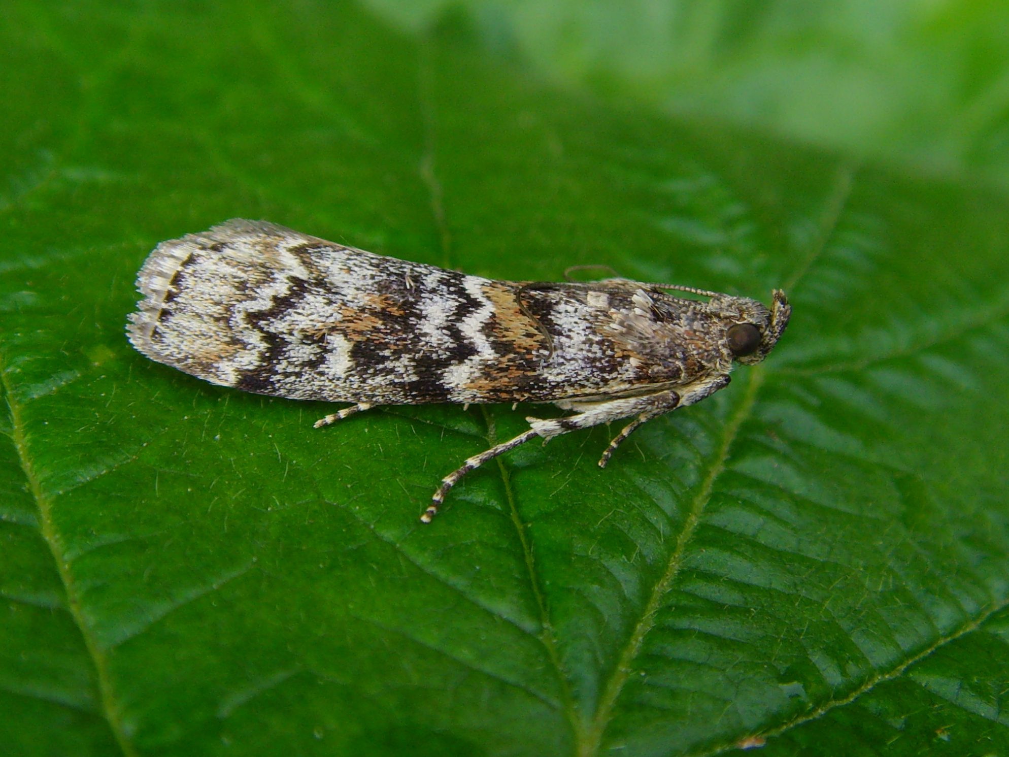
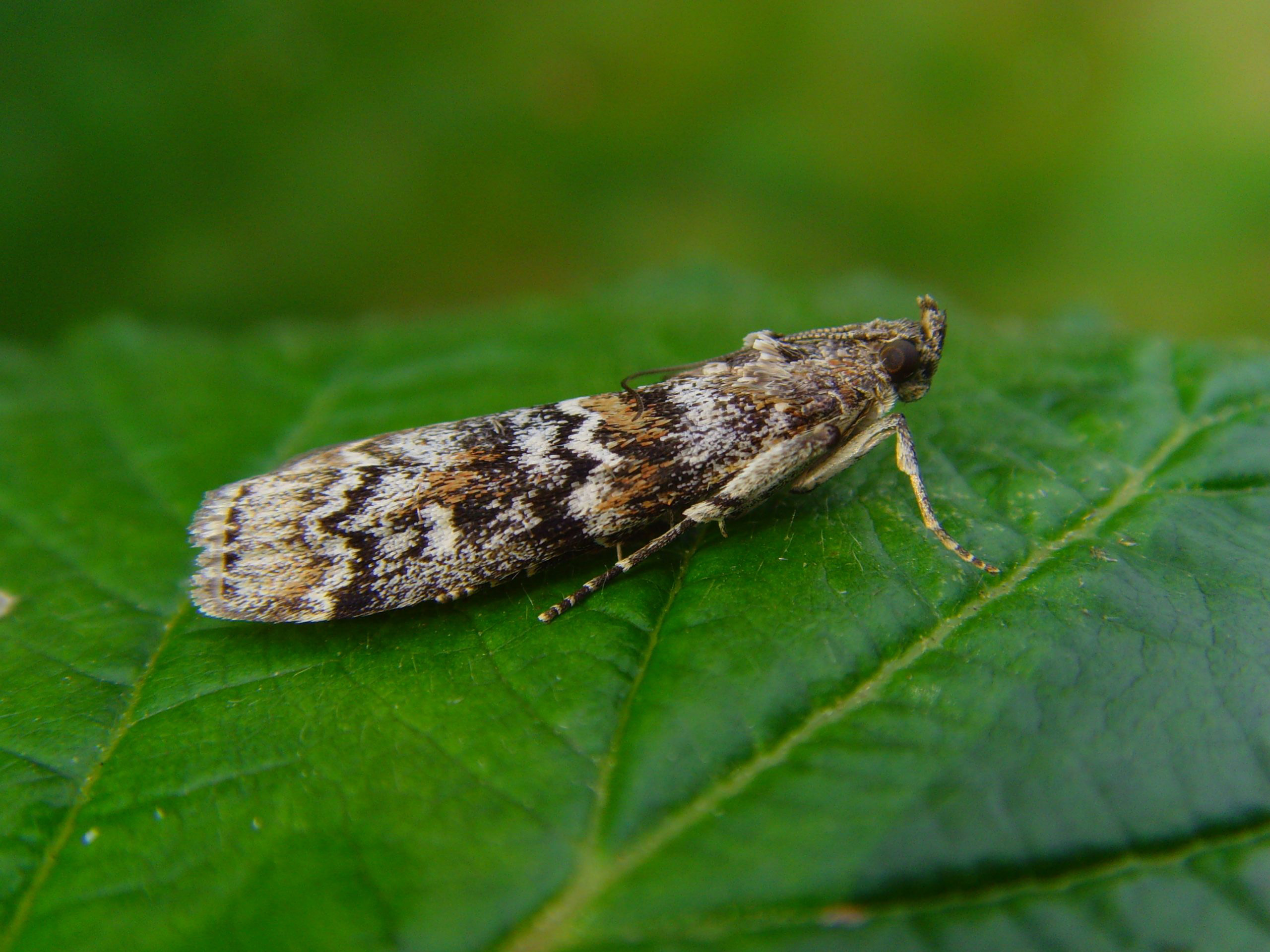

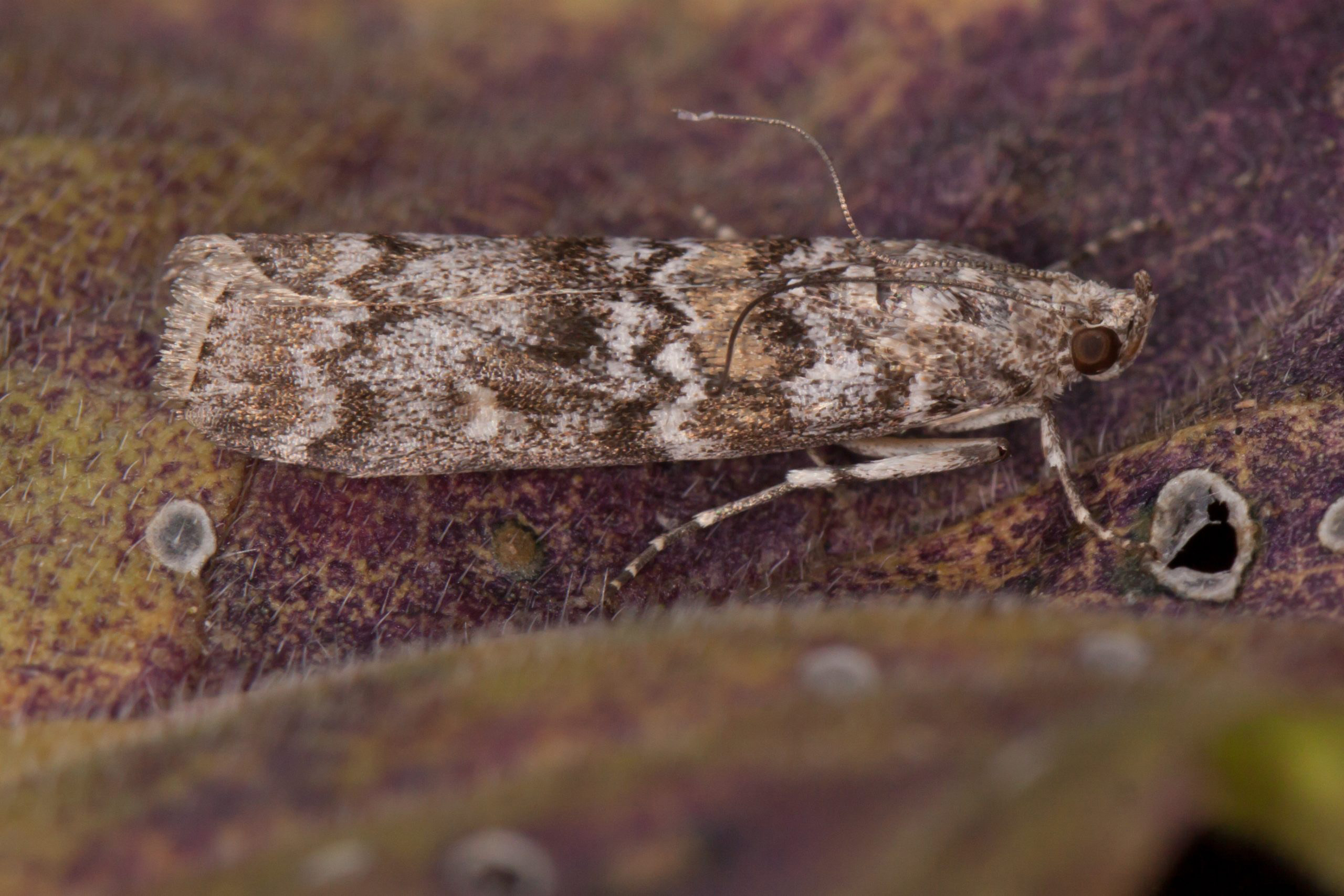
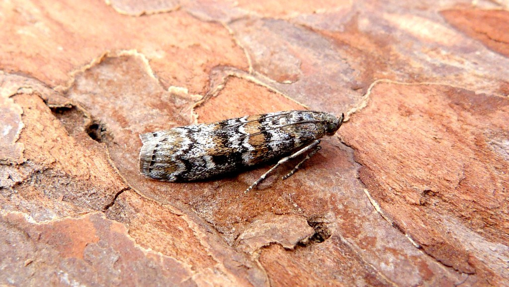

Image Gallery
No gallery images found for this moth.
Temporal Distribution Chart
Adults: (between 2003 - 2025)
Distribution Map for Dioryctria abietella
↳ from 2026+
↳ 25 from 2020 - 2025
↳ 21 from Before 2020
If the Map Layers function fails, just refresh the page and it should be OK after. Use the +- zoom on the top left, or on a tablet, use two fingers to zoom. Remember, the last layer you ticked is the one which displays the popup information - they sit on top of each other - de-select then re-select, to see the popup values.
Bedrock Geology ** indirectly affects moth distribution by influencing the type of habitat and food plants available in an area. In turn, this may affect the types of moths that can thrive, or where they can most likely be found.
NBN Atlas UK Distribution for – Dioryctria abietella
⚠️ Please wait for the map to load fully – do not click the link shown.
Note – the NBN Atlas datasets are listed in the map below and vary in their currency (uptodateness) – however,
the map does give a general indication of the moth's distribution across the UK.
Monthly Records By Year:
Dioryctria abietella
( data includes both Larvae and Adult Stages )
Monthly Counts By Year:
Dioryctria abietella
( data is based on 'Adult' stage records only )
First/Last Recorded Dates: Dioryctria abietella
Adult-only & Anything [Larvae, Pupae, Adult, Mines]
Shading shows moth presence between dates
Click the colour discs below to Select/De-select as Required
Recordings By Year: Dioryctria abietella
( All data includes both Larvae and Adult Stages )
Annual Growth Rate (AGR): Dioryctria abietella
AGR: 0% | Total % Change: 0%
Hectad (10kmx10km) Coverage: Dioryctria abietella
( data includes both Larvae and Adult Stages )
Flight Periods – Indicative –vs– Recorded Data
Dioryctria abietella
Dioryctria abietella
Flight Period chart – the grey hatched area above, which can cross one or more months, pictorially represents the best guess we have for this moth's flight periods [month/s]. The coloured lines represent the actual months seen in flight, from site observation records received between 2020-2026.
Records Behind the Map and Charts - Dioryctria abietella – 46 records available
Listed by Year - descending - scroll across to see all table columns
| Site Name | Tetrad | Date | Count | Stage | Recorder | Source | RecordKey |
|---|---|---|---|---|---|---|---|
| upper cromford garden | SK25Y | 27/07/2025 | 1 | Adult | Ashton, Clive | vc57_irecords_extract | iBRC43939014 |
| Belper | SK34U | 18/07/2025 | 1 | Adult | Evans, Dave | vc57_irecords_extract | iBRC43630269 |
| Findern, Derbyshire | SK33A | 17/07/2025 | 1 | Adult | Hallam, Brian | vc57_irecords_extract | iBRC43595095 |
| Longdendale, Torside willow and larch wood | SK09U | 13/07/2025 | 1 | Adult | Heintzen, Christian | vc57_irecords_extract | iBRC43980309 |
| Sandiacre Garden | SK43T | 25/10/2024 | 1 | Adult | Milnes, Emily | vc57_irecords_extract | iBRC40274993 |
| Buxton (w) | SK07R | 06/08/2024 | 1 | Adult | White, Ian | vc57_irecords_extract | iBRC37740651 |
| Wingerworth, Derbyshire | SK36Y | 27/07/2024 | 1 | Adult | Windle, Jim | vc57_irecords_extract | iBRC37388035 |
| Brockwell Chesterfield , Derbyshire. | SK37Q | 21/07/2024 | 1 | Adult | Ellen Smith | vc57_irecords_extract | iBRC37298891 |
| Midway, Derbys. | SK32A | 18/07/2024 | 1 | Adult | Williams, Michael | vc57_irecords_extract | iBRC39954573 |
| Woodland Ave | SK43R | 18/07/2024 | 1 | Adult | Thorpe, Steve | vc57_irecords_extract | iBRC40044850 |
| upper cromford garden | SK25Y | 17/07/2024 | 1 | Adult | Ashton, Clive | vc57_irecords_extract | iBRC37142362 |
| Ladycroft Ave, Buxton | SK07S | 14/07/2024 | 1 | Adult | Orridge, Steve | vc57_irecords_extract | iBRC37492341 |
| Allestree, Derby | SK33P | 10/07/2024 | 1 | Adult | Plant, Stephen | vc57_irecords_extract | iBRC36978731 |
| Sandiacre Garden | SK43T | 10/07/2024 | 1 | Adult | Milnes, Emily | vc57_irecords_extract | iBRC39285051 |
| Park Head, Crich. | SK35M | 30/06/2024 | 1 | Adult | Bradley, Jonathan | vc57_irecords_extract | iBRC37928071 |
| Allestree, Derby | SK33P | 27/06/2024 | 1 | Adult | Plant, Stephen | vc57_irecords_extract | iBRC48470103 |
| Belper | SK34N | 30/05/2024 | 1 | Adult | Evans, Dave | vc57_irecords_extract | iBRC36187132 |
| Woodland Ave | SK43R | 24/08/2021 | 1 | Adult | Thorpe, Steve | vc57_irecords_extract | iBRC33499360 |
| Woodland Ave | SK43R | 02/07/2021 | 1 | Adult | Thorpe, Steve | vc57_irecords_extract | iBRC33498563 |
| Main Street, Kings Newton | SK32Y | 17/08/2020 | 1 | Adult | Soar, Will | vc57_irecords_extract | iBRC34060541 |
| The Mays, Malthouse Lane, Froggatt | SK27N | 08/08/2020 | 1 | adult | BARNACLE, Mr B.&.Mrs.K. | Danes_2019-2021 | 414 |
| Findern, Derbyshire, DEAZ | SK33A | 04/07/2020 | 1 | Adult | Brian and Jean Hallam | vc57_irecords_extract | iBRC35163126 |
| The Mays, Malthouse Lane, Froggatt | SK27N | 01/07/2020 | 1 | adult | BARNACLE, Mr B.&.Mrs.K. | Danes_2019-2021 | 593 |
| Norton Lees | SK38L | 23/06/2020 | 1 | Adult | Mella, Pete | vc57_irecords_extract | iBRC50546134 |
| Woodland Ave | SK43R | 14/06/2020 | 1 | Adult | Thorpe, Steve | vc57_irecords_extract | iBRC33501049 |
| Birch Vale | SK08I | 02/08/2019 | 1 | Adult | Hewitt, Jane | vc57_irecords_extract | iBRC35072088 |
| Buxton SK, UK | SK07S | 17/07/2019 | 1 | Adult | Orridge, Steve | vc57_irecords_extract | iBRC25348200 |
| Ladycroft Ave, Buxton | SK07S | 16/07/2019 | 1 | Adult | Orridge, Steve | vc57_irecords_extract | iBRC35097135 |
| DRONFIELD WOODHOUSE | SK37J | 01/07/2015 | 1 | Adult | Williamson, Andy | vc57_irecords_extract | iBRC45698740 |
| The Old Manse, Ault Hucknall, Glapwell | SK46S | 22/07/2013 | 1 | Adult | M.E. Bradley | vc57_danes_bc_data | LC000334001CP94V |
| The Mays,Malthouse Lane,Froggatt | SK27N | 15/07/2012 | 1 | Adult | Barnacle, Brian | vc57_danes_bc_data | LC000334001CP801 |
| Whitesprings Plantation, Darley Dale | SK26X | 25/06/2011 | 1 | Adult | A. Butler | vc57_danes_bc_data | LC000334001COTVS |
| Robin Wood (central area) | SK32M | 04/08/2008 | 2 | Adult | Dave Budworth;P. Patrick;W. Soar | vc57_danes_bc_data | LC000334001CP4I7 |
| Robin Wood | SK32M | 03/08/2008 | 11 | Adult | Soar, Will | vc57_irecords_extract | iBRC34677316 |
| Melbourne, Derbyshire | SK32X | 04/07/2008 | 1 | Adult | Davison, Tony | vc57_irecords_extract | iBRC33419350 |
| Spinney Hill,Melbourne | SK32X | 04/07/2008 | 1 | Adult | Davison, Tony | vc57_danes_bc_data | LC000334001CP4BA |
| Midway Rd,Midway,Swadlincote | SK32A | 27/06/2008 | 1 | Adult | M.J. Williams | vc57_danes_bc_data | LC000334001COSIH |
| Far Cross,Cavendish Park,Matlock | SK36A | 23/08/2007 | 2 | Adult | B.L. Statham | vc57_danes_bc_data | LC000334001CP43W |
| Calke Park Ticknall Lime Yards | SK32R | 03/08/2007 | 1 | Adult | Finch, Graham Leonard | vc57_irecords_extract | iBRC35106005 |
| Ticknall Limeyards,Ticknall | SK32R | 03/08/2007 | 1 | Adult | G.L. Finch;M.A. Finch | vc57_danes_bc_data | LC000334001COSDC |
| Calke Park Meadow and Limes | SK32R | 08/07/2007 | 1 | Adult | Finch, Graham Leonard | vc57_irecords_extract | iBRC35105723 |
| Calke Park,Ticknall | SK32R | 06/07/2007 | 1 | Adult | Finch, Graham Leonard | vc57_danes_bc_data | LC000334001COS9F |
| The Hollies,Station Rd,Darley Dale | SK26R | 09/06/2007 | 1 | Adult | Roddis, Simon | vc57_danes_bc_data | LC000334001CP3TY |
| Edgecote Drive,Newhall,Swadlincote | SK22V | 21/09/2006 | 1 | Adult | Topliss, Neil | vc57_danes_bc_data | LC000334001CP3OT |
| The Hollies,Station Rd,Darley Dale | SK26R | 04/08/2004 | 1 | Adult | VC57 Derbyshire Recorder | vc57_danes_bc_data | LC000334001CP29R |
| Main Street, Kings Newton | SK32Y | 18/07/2003 | 1 | Adult | Soar, Will | vc57_irecords_extract | iBRC34677315 |