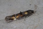
 Larval Case: C1 – Distinctive Species –
  – click for General Verification Guidelines | – click for Specific Verification Guidelines
  – Generally Common / Widespread
  – Leaf-miner
Mine Period Additional: The larvae feed on the leaves of rosebay willowherb (Epilobium angustifolium).
Mine ID Difficulty: Not Recorded
Mine Type/s: Not Recorded
Mine Feeding Method/s: Not Recorded
Mine Comment: None.
Blue-coded] moths is not displayed/updated in this tab. However, all verified records for this moth are listed in the RECORDS tab below. 

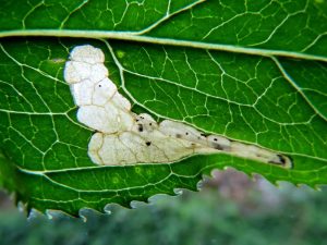

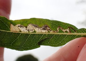

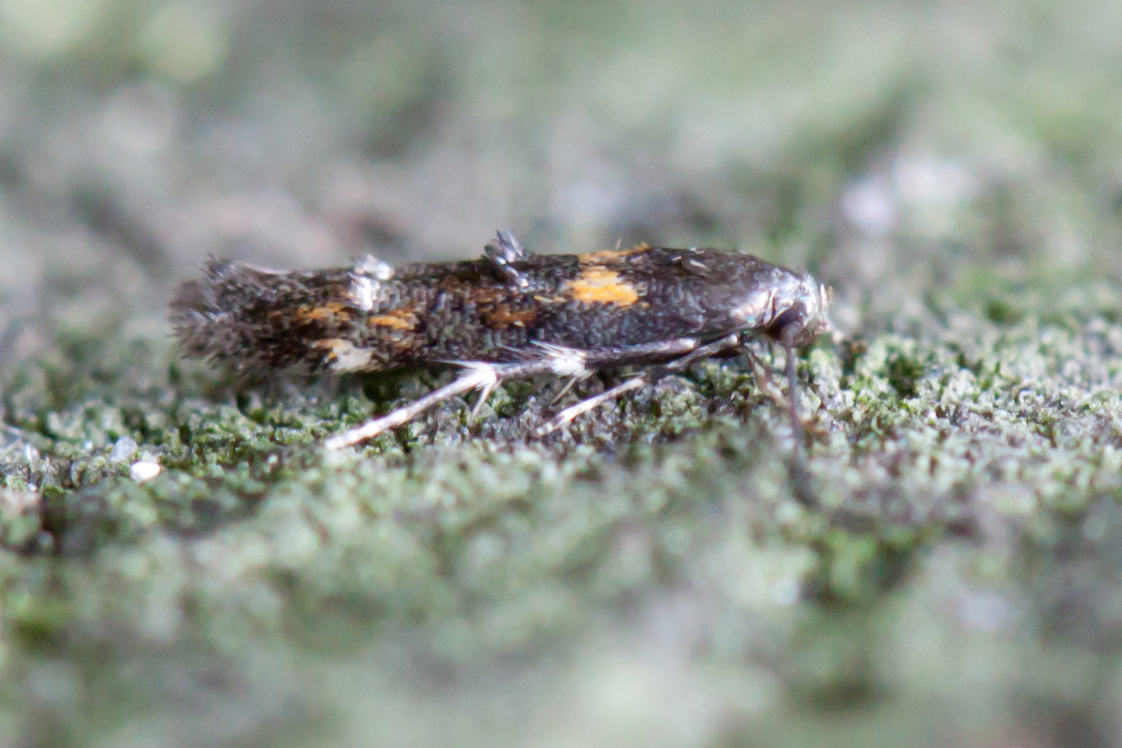
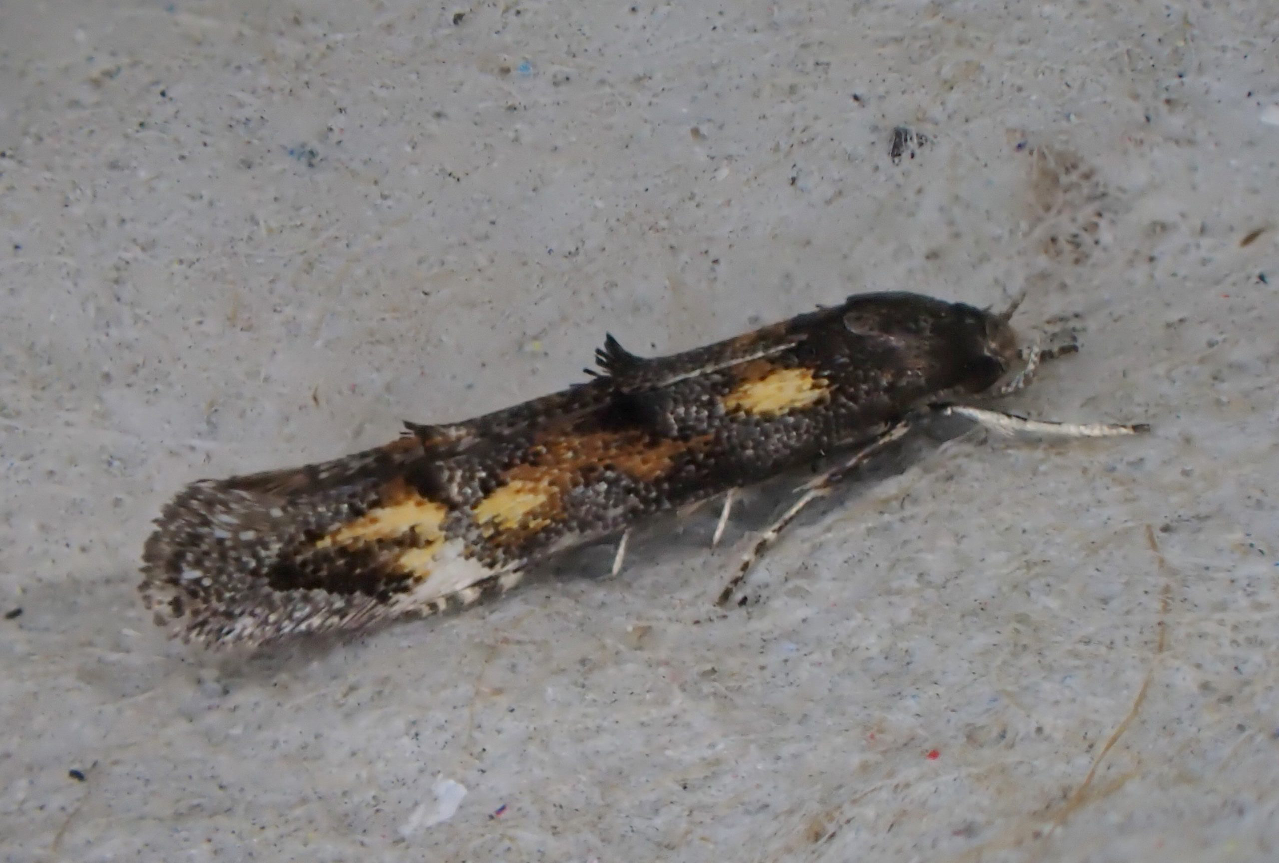

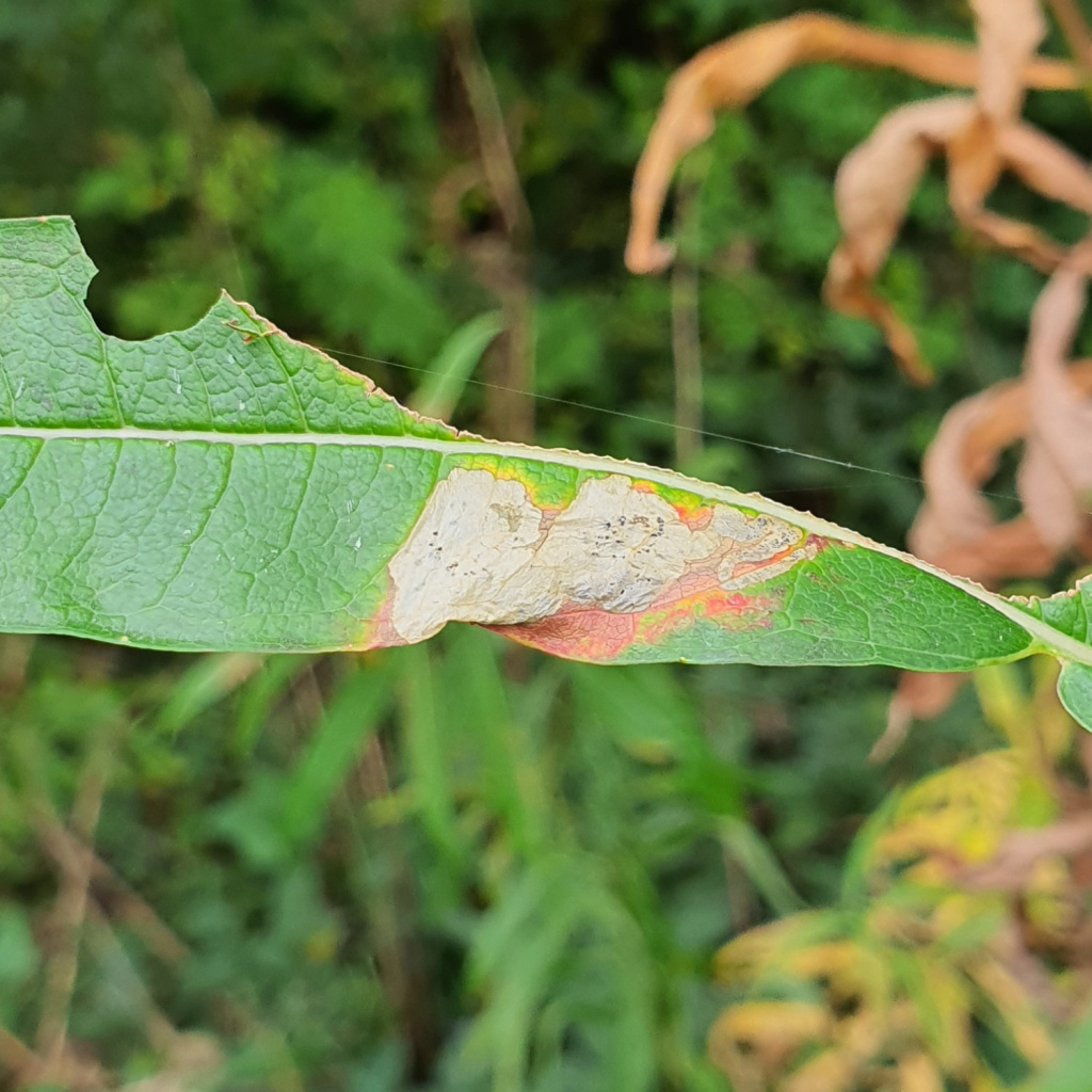

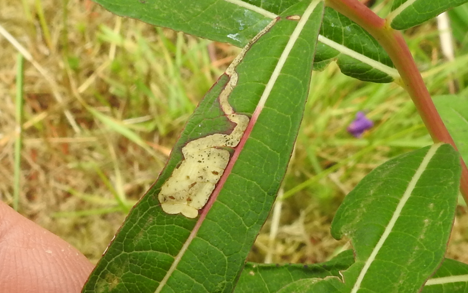
Image Gallery
No gallery images found for this moth.
Temporal Distribution Chart
Adults: (between 2002 - 2026) | Immatures: (between 2001 - 2026)
Distribution Map for Mompha raschkiella
↳ 3 from 2026+
↳ 47 from 2020 - 2025
↳ 36 from Before 2020
If the Map Layers function fails, just refresh the page and it should be OK after. Use the +- zoom on the top left, or on a tablet, use two fingers to zoom. Remember, the last layer you ticked is the one which displays the popup information - they sit on top of each other - de-select then re-select, to see the popup values.
Bedrock Geology ** indirectly affects moth distribution by influencing the type of habitat and food plants available in an area. In turn, this may affect the types of moths that can thrive, or where they can most likely be found.
NBN Atlas UK Distribution for – Mompha raschkiella
⚠️ Please wait for the map to load fully – do not click the link shown.
Note – the NBN Atlas datasets are listed in the map below and vary in their currency (uptodateness) – however,
the map does give a general indication of the moth's distribution across the UK.
Monthly Records By Year:
Mompha raschkiella
( data includes both Larvae and Adult Stages )
Monthly Counts By Year:
Mompha raschkiella
( data is based on 'Adult' stage records only )
First/Last Recorded Dates: Mompha raschkiella
Adult-only & Anything [Larvae, Pupae, Adult, Mines]
Shading shows moth presence between dates
Click the colour discs below to Select/De-select as Required
Recordings By Year: Mompha raschkiella
( All data includes both Larvae and Adult Stages )
Annual Growth Rate (AGR): Mompha raschkiella
AGR: 5.33% | Total % Change: 266.7%
Hectad (10kmx10km) Coverage: Mompha raschkiella
( data includes both Larvae and Adult Stages )
Flight Periods – Indicative –vs– Recorded Data
Mompha raschkiella
Mompha raschkiella
Flight Period chart – the grey hatched area above, which can cross one or more months, pictorially represents the best guess we have for this moth's flight periods [month/s]. The coloured lines represent the actual months seen in flight, from site observation records received between 2020-2026.
Mine Periods – Indicative –vs– Recorded Data
Mompha raschkiella
Mompha raschkiella
( data includes both Larvae and Adult Stages )
Mine Period chart – the grey hatched area above, which can cross one or more months, pictorially represents the best guess we have for this moth's mine periods [month/s]. The coloured lines represent the actual months seen mining, from site observation records received between 2020-2026.
Records Behind the Map and Charts - Mompha raschkiella – 86 records available
Listed by Year - descending - scroll across to see all table columns
| Site Name | Tetrad | Date | Count | Stage | Recorder | Source | RecordKey |
|---|---|---|---|---|---|---|---|
| Darwin Forest | SK36C | 17/06/2026 | 3 | mine | Evans, Dave | vc57_irecords_extract | iBRC53825380 |
| DWT Wyver Lane | SK34P | 08/06/2026 | 7 | mine (empty) | Evans, Dave | vc57_irecords_extract | iBRC53288777 |
| Buxton SK, UK | SK07S | 23/05/2026 | 1 | Adult | MarkCocker | vc57_irecords_extract | iBRC52626549 |
| Swarkestone, Derbyshire | SK32U | 11/10/2025 | 3 | mine | Shervill, Andrew | vc57_irecords_extract | iBRC45891617 |
| Woodhead, Trans Pennine Trail | SK19E | 10/10/2025 | 6 | Leaf-mine | Heintzen, Christian | vc57_irecords_extract | iBRC48921873 |
| Darwin Forest | SK36C | 06/10/2025 | 2 | mine (empty) | Evans, Dave | vc57_irecords_extract | iBRC45819784 |
| Darwin Forest | SK26X | 04/10/2025 | 5 | mine (empty) | Evans, Dave | vc57_irecords_extract | iBRC45786886 |
| Longdendale, Trans Pennine Trail | SK09Z | 11/09/2025 | 2 | Leaf-mine | Heintzen, Christian | vc57_irecords_extract | iBRC48921872 |
| Hayfield, Mount Famine | SK08M | 02/09/2025 | 2 | Leaf-mine | Heintzen, Christian | vc57_irecords_extract | iBRC48921871 |
| DWT Wyver Lane | SK34P | 13/08/2025 | 1 | mine (empty) | Evans, Dave | vc57_irecords_extract | iBRC44440751 |
| Shaw Farm, New Mills VC | SJ98Y | 12/08/2025 | 1 | mine | Hind, Steve | vc57_irecords_extract | iBRC44526624 |
| Belper | SK34U | 10/08/2025 | 1 | Adult | Evans, Dave | vc57_irecords_extract | iBRC44352345 |
| DWT Wyver Lane | SK34P | 06/08/2025 | 1 | mine (empty) | Evans, Dave | vc57_irecords_extract | iBRC44213544 |
| Grinlow Woods (east) | SK07L | 01/08/2025 | 1 | mine | Mortin, Jon | vc57_irecords_extract | iBRC44066888 |
| Chaddesden Garden | SK33T | 13/07/2025 | 1 | Adult | loverock, neil | vc57_irecords_extract | iBRC43373877 |
| Ferneydale Grassland LNR | SK07Q | 24/06/2025 | 1 | mine | Mortin, Jon | vc57_irecords_extract | iBRC42605005 |
| Mousley Bottom LNR | SJ98X | 22/06/2025 | 1 | mine | Mortin, Jon | vc57_irecords_extract | iBRC50062608 |
| Gleadless Valley LNR | SK38R | 21/06/2025 | 1 | Adult | Mella, Pete | vc57_irecords_extract | iBRC42497386 |
| Havercroft Road | SK38L | 13/06/2025 | 1 | Adult | Tait, Malcolm | vc57_irecords_extract | iBRC42292463 |
| Eyam | SK27C | 08/06/2025 | 1 | Adult | Samuel P.C. | vc57_irecords_extract | iBRC42913516 |
| Stoney Middleton, Hope Valley SUB, UK | SK27C | 08/06/2025 | 1 | Adult | Elena Obradović | vc57_irecords_extract | iBRC42913517 |
| Buxton SK, UK | SK07S | 28/04/2025 | 1 | Adult | Orridge, Steve | vc57_irecords_extract | iBRC41215111 |
| Ladycroft Ave, Buxton | SK07S | 27/04/2025 | 1 | Adult | Orridge, Steve | vc57_irecords_extract | iBRC41604751 |
| Monsall Trail | SK17R | 14/10/2024 | 1 | mine | Harvey, Martin C. | vc57_irecords_extract | iBRC38898622 |
| River Derwent, Derby | SK33S | 21/09/2024 | 1 | mine | Neil Gregory | vc57_irecords_extract | iBRC38567593 |
| River Derwent, Derby | SK33S | 21/09/2024 | 1 | mine | Neil Gregory | vc57_irecords_extract | iBRC38567612 |
| Ferneydale Grassland LNR | SK07Q | 15/09/2024 | 1 | Adult | Mortin, Jon | vc57_irecords_extract | iBRC38723700 |
| Cote Heath Park, Buxton | SK07R | 12/09/2024 | 1 | mine | Mortin, Jon | vc57_irecords_extract | iBRC38436879 |
| Cote Heath Allotments, Buxton | SK07R | 12/09/2024 | 1 | Adult | Mortin, Jon | vc57_irecords_extract | iBRC38775315 |
| Olwer Tor | SK28K | 12/09/2024 | 1 | Mine | Jack Oughton | vc57_irecords_extract | iBRC39791150 |
| Darley Bridge | SK26Q | 14/08/2024 | 1 | Adult | Moores, Stephen | vc57_irecords_extract | iBRC38019555 |
| Ladycroft Ave, Buxton | SK07S | 25/05/2024 | 1 | Adult | Orridge, Steve | vc57_irecords_extract | iBRC36182204 |
| Calke Park | SK32R | 01/10/2023 | 1 | Mine | Finch, Graham Leonard | vc57_irecords_extract | iBRC35105557 |
| Carver's Rocks | SK32G | 30/09/2023 | 1 | Mine | Finch, Graham Leonard | vc57_irecords_extract | iBRC35106095 |
| Ladycroft Ave | SK07S | 08/09/2023 | 3 | Adult | Orridge, Steve | vc57_irecords_extract | iBRC35076055 |
| Springwater Lakes | SK53B | 26/08/2023 | 3 | mine | Gregory, Neil | vc57_irecords_extract | iBRC32653363 |
| Ladycroft Ave | SK07S | 15/08/2023 | 1 | Adult | Orridge, Steve | vc57_irecords_extract | iBRC35076469 |
| Buxton SK, UK | SK07S | 22/09/2022 | 1 | Adult | Orridge, Steve | vc57_irecords_extract | iBRC28811860 |
| Sherbrook Lodge, Buxton | SK07R | 02/09/2022 | 1 | Larva | Mortin, Jon | vc57_irecords_extract | iBRC27949220 |
| Buxton SK, UK | SK07S | 03/06/2021 | 1 | Adult | Orridge, Steve | vc57_irecords_extract | iBRC22734759 |
| Former Saint-Gobain Pipeworks, Staveley [centroid] | SK47C | 20/10/2020 | 1 | Adult | Godfrey, A. | vc57_irecords_extract | iBRC33989143 |
| Former Saint-Gobain Pipeworks, Staveley [centroid] | SK47C | 30/08/2020 | 1 | Adult | Godfrey, A. | vc57_irecords_extract | iBRC33989144 |
| Former Staveley Iron Works, Staveley [centroid] | SK47C | 30/08/2020 | 1 | Adult | Godfrey, A. | vc57_irecords_extract | iBRC33990046 |
| Lady Canning's Plantation | SK28W | 24/08/2020 | 1 | Larva | Watchorn, Andrew | vc57_irecords_extract | iBRC17751538 |
| Former Staveley Chemical Works, Staveley [centroid] | SK47H | 29/07/2020 | 2 | Adult | Godfrey, A. | vc57_irecords_extract | iBRC33989656 |
| Coombs Dale, Calver | SK27C | 20/07/2020 | 1 | Larva | Watchorn, Andrew | vc57_irecords_extract | iBRC16110180 |
| Former Saint-Gobain Pipeworks, Staveley [centroid] | SK47C | 11/07/2020 | 1 | Adult | Godfrey, A. | vc57_irecords_extract | iBRC33989145 |
| Buxton SK, UK | SK07S | 25/06/2020 | 1 | Adult | Orridge, Steve | vc57_irecords_extract | iBRC22320039 |
| Ladycroft Ave, Buxton | SK07S | 20/05/2020 | 1 | Adult | Orridge, Steve | vc57_irecords_extract | iBRC35094847 |
| Ladycroft Ave, Buxton | SK07S | 09/05/2020 | 1 | Adult | Orridge, Steve | vc57_irecords_extract | iBRC35094731 |
| Ladycroft Ave | SK07S | 27/07/2018 | 1 | Adult | Orridge, Steve | vc57_irecords_extract | iBRC49167305 |
| Lightwood Reservoir | SK07M | 25/07/2018 | 1 | Adult | Orridge, Steve | vc57_irecords_extract | iBRC49168394 |
| Main Street, Kings Newton | SK32Y | 16/07/2018 | 1 | Adult | Soar, Will | vc57_irecords_extract | iBRC34060127 |
| Ladycroft Ave, Buxton | SK07S | 14/07/2018 | 1 | Adult | Steve A. Orridge | vc57_irecords_extract | iBRC49168415 |
| Shillito Wood | SK27X | 30/08/2016 | 5 | Larva | Watchorn, Andrew | vc57_irecords_extract | iBRC3987387 |
| Ladycroft Ave | SK07S | 18/08/2016 | 1 | Adult | Orridge, Steve | vc57_irecords_extract | iBRC41052068 |
| Carvers Rocks NR, Ticknall | SK32G | 05/09/2014 | 3 | Larval Mine | Dave Budworth | vc57_danes_bc_data | LC000334001CP9MD |
| Newhall,Swadlincote | SK22V | 09/06/2014 | 2 | Larval Mine | Dave Budworth | vc57_danes_bc_data | LC000334001CP9JB |
| Millers Dale | SK17G | 03/09/2011 | 1 | Larval Mine | S.H. Hind | vc57_danes_bc_data | LC000334001CP7LG |
| Whitwell Wood,Whitwell,Worksop | SK57J | 24/05/2011 | 1 | Adult | K.R. Huston | vc57_danes_bc_data | LC000334001COXN4 |
| Bamford | SK28B | 21/09/2010 | 1 | Larval Mine | K. McCabe;S.H. Hind | vc57_danes_bc_data | LC000334001CP6OI |
| Lathkill Dale | SK16Y | 04/09/2010 | 1 | Larval Mine | S.H. Hind | vc57_danes_bc_data | LC000334001CP6LS |
| Oaks Barn Cottage, Monyash Rd, Over Haddon, Bakewell | SK26D | 04/09/2010 | 1 | Larval Mine | S.H. Hind | vc57_danes_bc_data | LC000334001CP6LW |
| Ladybower Resr | SK18U | 03/09/2010 | 1 | Larval Mine | S.H. Hind | vc57_danes_bc_data | LC000334001COXJF |
| Howden Resr | SK19S | 25/08/2010 | 1 | Larval Mine | S.H. Hind | vc57_danes_bc_data | LC000334001COXHV |
| Slippery Stones,Upper Derwent | SK19S | 25/08/2010 | 1 | Larval Mine | S.H. Hind | vc57_danes_bc_data | LC000334001COXIB |
| Padley Gorge, Nether Padley | SK27P | 19/08/2010 | 1 | Larval Mine | S.H. Hind | vc57_danes_bc_data | LC000334001CP6HS |
| Carvers Rocks, Hartshorne, Swadlincote | SK32G | 18/08/2010 | 1 | Larval Mine | Dave Budworth | vc57_danes_bc_data | LC000334001COTMV |
| Carvers Rocks area,Hartshorne | SK32G | 27/07/2010 | 2 | Larval Mine | Dave Budworth | vc57_danes_bc_data | LC000334001CP65I |
| Dovedale | SK15K | 25/07/2010 | 1 | Adult | D. Grundy | vc57_danes_bc_data | LC000334001COTFO |
| Dovedale | SK15K | 25/07/2010 | 1 | Adult | D. Grundy | vc57_danes_bc_data | LC000334001COTG7 |
| Linacre | SK37L | 13/10/2009 | 1 | Larval Mine | S.H. Hind | vc57_danes_bc_data | LC000334001CP54Z |
| Coombs Dale,Stoney Middleton | SK27H | 12/10/2009 | 1 | Larval Mine | S.H. Hind | vc57_danes_bc_data | LC000334001CP53W |
| Carvers Rocks,Hartshorne | SK32G | 09/10/2009 | 5 | Larval Mine | Dave Budworth | vc57_danes_bc_data | LC000334001CP53F |
| Pin Dale | SK18L | 10/09/2009 | 1 | Larval Mine | S.H. Hind | vc57_danes_bc_data | LC000334001COWXD |
| Carvers Rocks area (new plantation) | SK32G | 25/07/2009 | 2 | Larval Mine | Dave Budworth | vc57_danes_bc_data | LC000334001COWUJ |
| Strines, New Mills | SJ98T | 17/09/2008 | 1 | Larval Mine | S.H. Hind | vc57_danes_bc_data | LC000334001CP4L8 |
| Monsall Trail, Buxton | SK17L | 14/09/2008 | 1 | Larval Mine | S.H. Hind | vc57_danes_bc_data | LC000334001COSNL |
| Mousley Bottom, New Mills | SJ98X | 03/09/2007 | 1 | Larval Mine | S.H. Hind | vc57_danes_bc_data | LC000334001CP44Q |
| Beeley Moor Triangle | SK26Y | 25/08/2007 | 1 | Adult | Finch, Graham Leonard | vc57_irecords_extract | iBRC35105404 |
| Beeley Triangle, Beeley Moor, Beeley | SK26Y | 25/08/2007 | 1 | Adult | G.L. Finch;M.A. Finch | vc57_danes_bc_data | LC000334001COSFE |
| Carr Vale NR,Bolsover | SK46P | 13/09/2006 | 1 | Larval Mine | S.H. Hind | vc57_danes_bc_data | LC000334001COW8K |
| Carr Vale NR,Bolsover | SK47K | 13/09/2006 | 1 | Larval Mine | S.H. Hind | vc57_danes_bc_data | LC000334001CP3N1 |
| Beeley Moor, Beeley | SK26Z | 03/06/2006 | 1 | Adult | B.L. Statham;G.L. Finch;M.A. Finch | vc57_danes_bc_data | LC000334001CP2X6 |
| Hilton Gravel Pits, Hilton, Burton on Trent | SK23K | 04/06/2002 | 1 | Adult | Dave Budworth | vc57_danes_bc_data | LC000334001CP1G9 |
| Cubley, nr Ashbourne | SK13U | 04/10/2001 | 1 | Larval Mine | S.H. Hind | vc57_danes_bc_data | LC000334001CP1F4 |