
 Leaf-miner: CAT L – The leaf or a Photo required –
  Larval Case: C1 – Distinctive Species –
  – click for General Verification Guidelines | – click for Specific Verification Guidelines
  – Generally Common / Widespread
  – Leaf-miner
Mine Period Additional: May & June and late July – September – Overwinters as a pupae outside the mine
Mine ID Difficulty:
Mine Type/s: Gallery
Mine Feeding Method/s: Not Recorded
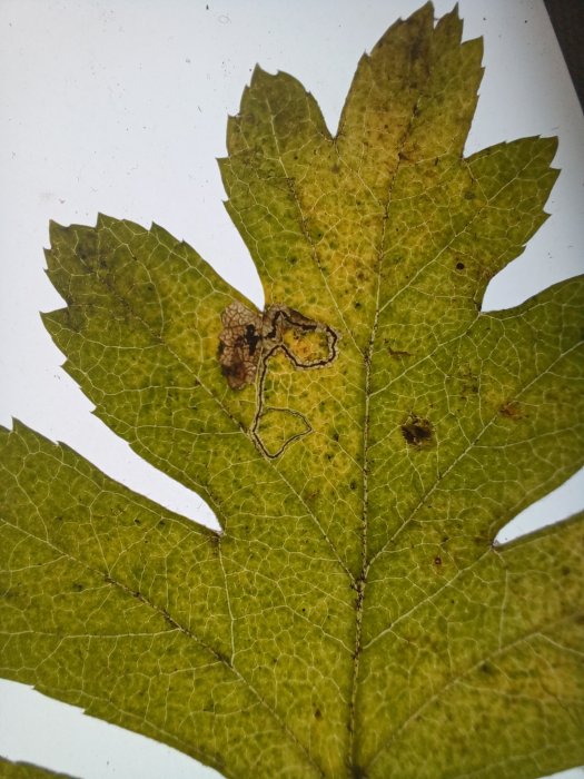
Mine Comment: The larvae mine the leaves of Hawthorn. The mine starts as a slender, winding corridor with a central line of frass, which then abruptly widens into a blotch with irregular frass, usually located along the leaf margin.
Blue-coded] moths is not displayed/updated in this tab. However, all verified records for this moth are listed in the RECORDS tab below. 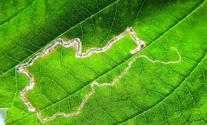

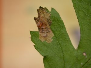

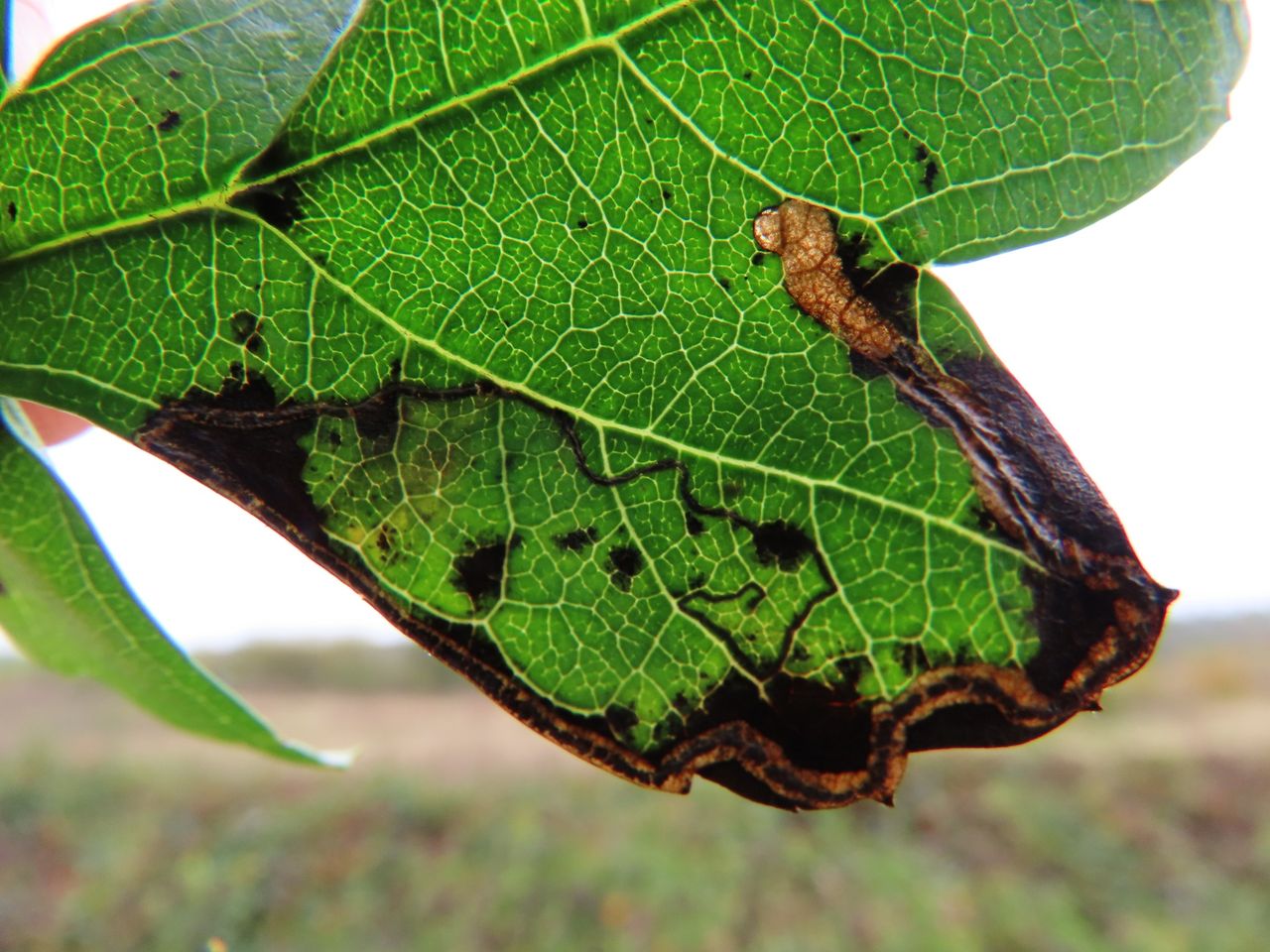

Image Gallery


Temporal Distribution Chart
Immatures: (between 2001 - 2026)
Distribution Map for Stigmella hybnerella
↳ 1 from 2026+
↳ 16 from 2020 - 2025
↳ 30 from Before 2020
If the Map Layers function fails, just refresh the page and it should be OK after. Use the +- zoom on the top left, or on a tablet, use two fingers to zoom. Remember, the last layer you ticked is the one which displays the popup information - they sit on top of each other - de-select then re-select, to see the popup values.
Bedrock Geology ** indirectly affects moth distribution by influencing the type of habitat and food plants available in an area. In turn, this may affect the types of moths that can thrive, or where they can most likely be found.
NBN Atlas UK Distribution for – Stigmella hybnerella
⚠️ Please wait for the map to load fully – do not click the link shown.
Note – the NBN Atlas datasets are listed in the map below and vary in their currency (uptodateness) – however,
the map does give a general indication of the moth's distribution across the UK.
Monthly Records By Year:
Stigmella hybnerella
( data includes both Larvae and Adult Stages )
Monthly Counts By Year:
Stigmella hybnerella
( data is based on 'Adult' stage records only )
First/Last Recorded Dates: Stigmella hybnerella
Adult-only & Anything [Larvae, Pupae, Adult, Mines]
Shading shows moth presence between dates
Click the colour discs below to Select/De-select as Required
Recordings By Year: Stigmella hybnerella
( All data includes both Larvae and Adult Stages )
Annual Growth Rate (AGR): Stigmella hybnerella
AGR: 0% | Total % Change: 0%
Hectad (10kmx10km) Coverage: Stigmella hybnerella
( data includes both Larvae and Adult Stages )
Flight Periods – Indicative –vs– Recorded Data
Stigmella hybnerella
Stigmella hybnerella
Flight Period chart – the grey hatched area above, which can cross one or more months, pictorially represents the best guess we have for this moth's flight periods [month/s]. The coloured lines represent the actual months seen in flight, from site observation records received between 2020-2026.
Mine Periods – Indicative –vs– Recorded Data
Stigmella hybnerella
Stigmella hybnerella
( data includes both Larvae and Adult Stages )
Mine Period chart – the grey hatched area above, which can cross one or more months, pictorially represents the best guess we have for this moth's mine periods [month/s]. The coloured lines represent the actual months seen mining, from site observation records received between 2020-2026.
Records Behind the Map and Charts - Stigmella hybnerella – 47 records available
Listed by Year - descending - scroll across to see all table columns
| Site Name | Tetrad | Date | Count | Stage | Recorder | Source | RecordKey |
|---|---|---|---|---|---|---|---|
| DWT Wyver Lane | SK34P | 08/06/2026 | 1 | mine (empty) | Evans, Dave | vc57_irecords_extract | iBRC53288776 |
| Sunnydale LNR | SK33G | 28/09/2025 | 3 | mine | Shervill, Andrew | vc57_irecords_extract | iBRC45674501 |
| Ingleby Ave, Derby | SK33L | 28/09/2025 | 3 | mine | Shervill, Andrew | vc57_irecords_extract | iBRC45674951 |
| DWT Wyver Lane | SK34P | 09/09/2025 | 15 | mine (empty) | Evans, Dave | vc57_irecords_extract | iBRC45208279 |
| DWT Wyver Lane | SK34P | 02/09/2025 | 17 | mine (tenant | Evans, Dave | vc57_irecords_extract | iBRC45019513 |
| DWT Wyver Lane | SK34P | 26/08/2025 | 15 | mine (empty) | Evans, Dave | vc57_irecords_extract | iBRC44786055 |
| Graves Park | SK38L | 26/08/2025 | 1 | mine | Mella, Pete | vc57_irecords_extract | iBRC48913287 |
| Ashwood Dale (north), Buxton | SK07R | 23/08/2025 | 1 | mine | Mortin, Jon | vc57_irecords_extract | iBRC44735842 |
| DWT Wyver Lane | SK34P | 20/08/2025 | 124 | mine (empty) | Evans, Dave | vc57_irecords_extract | iBRC44638481 |
| DWT Wyver Lane | SK34P | 13/08/2025 | 5 | mine (empty) | Evans, Dave | vc57_irecords_extract | iBRC44440719 |
| DWT Wyver Lane | SK34P | 06/08/2025 | 2 | mine (empty) | Evans, Dave | vc57_irecords_extract | iBRC44213447 |
| DWT Wyver Lane | SK34P | 23/07/2025 | 3 | mine (empty) | Evans, Dave | vc57_irecords_extract | iBRC43746487 |
| DWT Wyver Lane | SK34P | 30/10/2024 | 3 | mine (empty) | Evans, Dave | vc57_irecords_extract | iBRC39056470 |
| DWT Wyver Lane | SK34P | 12/09/2024 | 5 | mine (empty) | Evans, Dave | vc57_irecords_extract | iBRC38431869 |
| DWT Wyver Lane | SK34P | 04/09/2024 | 6 | mine (empty) | Evans, Dave | vc57_irecords_extract | iBRC38312384 |
| Lower Gamesley VC | SK09C | 31/08/2024 | 1 | mine (empty) | Hind, Steve | vc57_irecords_extract | iBRC38243515 |
| Allestree Park | SK34K | 25/09/2022 | 1 | Mine | Finch, Graham Leonard | vc57_irecords_extract | iBRC35105356 |
| Derbyshire, UK | SK07M | 08/10/2019 | 1 | Larva | Orridge, Steve | vc57_irecords_extract | iBRC23090430 |
| Ashford in the Water | SK16Z | 22/09/2010 | 1 | Larval Mine | S.A. Orridge;S.H. Hind | vc57_danes_bc_data | LC000334001COZGM |
| Ashford in the Water | SK16Z | 22/09/2010 | 1 | Larval Mine | S.A. Orridge;S.H. Hind | vc57_danes_bc_data | LC000334001CP6P1 |
| Bamford | SK28B | 21/09/2010 | 1 | Larval Mine | K. McCabe;S.H. Hind | vc57_danes_bc_data | LC000334001COTQ5 |
| Oaks Barn Cottage, Monyash Rd, Over Haddon, Bakewell | SK26D | 04/09/2010 | 1 | Larval Mine | S.H. Hind | vc57_danes_bc_data | LC000334001CP6LX |
| Ladybower Resr | SK18U | 03/09/2010 | 1 | Larval Mine | S.H. Hind | vc57_danes_bc_data | LC000334001COXIT |
| Howden Resr | SK19L | 25/08/2010 | 1 | Larval Mine | S.H. Hind | vc57_danes_bc_data | LC000334001CP09D |
| Hopton Wood NR, Cromford | SK25T | 16/10/2009 | 1 | Larval Mine | Dave Budworth;S.A. Orridge;S.H. Hind | vc57_danes_bc_data | LC000334001CP55I |
| Rose End Meadows NR,Cromford | SK25Y | 16/10/2009 | 1 | Larval Mine | Dave Budworth;S.A. Orridge;S.H. Hind | vc57_danes_bc_data | LC000334001CP569 |
| Linacre | SK37G | 13/10/2009 | 1 | Larval Mine | S.H. Hind | vc57_danes_bc_data | LC000334001CP54I |
| Coombs Dale,Stoney Middleton | SK27H | 12/10/2009 | 1 | Larval Mine | S.H. Hind | vc57_danes_bc_data | LC000334001COWZ6 |
| Coombs Dale,Stoney Middleton | SK27H | 12/10/2009 | 1 | Larval Mine | S.H. Hind | vc57_danes_bc_data | LC000334001CP547 |
| Hope | SK18R | 07/10/2009 | 1 | Larval Mine | S.H. Hind | vc57_danes_bc_data | LC000334001COSZS |
| Derbyshire, UK | SK14G | 02/10/2009 | 1 | Larva | Orridge, Steve | vc57_irecords_extract | iBRC44387184 |
| Norbury | SK14G | 01/10/2009 | 1 | Larval Mine | Dave Budworth;S.A. Orridge;S.H. Hind | vc57_danes_bc_data | LC000334001COWY9 |
| Tissington Trail, Ashbourne | SK14T | 01/10/2009 | 1 | Larval Mine | Dave Budworth;S.A. Orridge;S.H. Hind | vc57_danes_bc_data | LC000334001CP05O |
| Castleton | SK18L | 10/09/2009 | 1 | Larval Mine | S.H. Hind | vc57_danes_bc_data | LC000334001COWX7 |
| Pin Dale | SK18L | 10/09/2009 | 1 | Larval Mine | S.H. Hind | vc57_danes_bc_data | LC000334001COWXI |
| Lathkill Dale,Bakewell | SK16Y | 19/09/2008 | 1 | Larval Mine | Dave Budworth;S.H. Hind | vc57_danes_bc_data | LC000334001CP4LR |
| Oaks Barn Cottage, Monyash Rd, Over Haddon, Bakewell | SK26D | 19/09/2008 | 1 | Larval Mine | Dave Budworth;S.H. Hind | vc57_danes_bc_data | LC000334001CP4M3 |
| Monsall Trail, Buxton | SK17L | 14/09/2008 | 1 | Larval Mine | S.H. Hind | vc57_danes_bc_data | LC000334001COSNX |
| Cramside Wood (DWT reserve) | SK17R | 20/06/2007 | 1 | Larval Mine | S.H. Hind | vc57_danes_bc_data | LC000334001CP3VD |
| Tideswell Dale | SK17M | 09/06/2007 | 1 | Larval Mine | S.H. Hind | vc57_danes_bc_data | LC000334001CP3TW |
| Carr Vale NR,Bolsover | SK46P | 13/09/2006 | 1 | Larval Mine | S.H. Hind | vc57_danes_bc_data | LC000334001COW8R |
| Carr Vale NR,Bolsover | SK47K | 13/09/2006 | 1 | Larval Mine | S.H. Hind | vc57_danes_bc_data | LC000334001CP3NC |
| Hillclifflane, nr Idridgehay | SK24Y | 02/11/2002 | 1 | Larval Mine | S.H. Hind | vc57_danes_bc_data | LC000334001CP1HI |
| Brackley Gate, nr Coxbench | SK34W | 03/11/2001 | 1 | Larval Mine | S.H. Hind | vc57_danes_bc_data | LC000334001COR0K |
| Abbotsholme School, Rocester | SK13E | 04/10/2001 | 1 | Larval Mine | S.H. Hind | vc57_danes_bc_data | LC000334001CP1ET |
| Repton Shrubs, Repton | SK32B | 01/01/1905 | 1 | Adult | VC57 Derbyshire Recorder | vc57_danes_bc_data | LC000334001COQGM |
| Burton on Trent area (site not precise) | SK22K | 01/01/1863 | 1 | Adult | VC57 Derbyshire Recorder | vc57_danes_bc_data | LC000334001CP9QQ |