

 – click for General Verification Guidelines |
– click for Specific Verification Guidelines
– click for General Verification Guidelines |
– click for Specific Verification Guidelines
 – Generally Common / Widespread
 – Leaf-miner
Confusion Species: Gypsonoma sociana
Mine Period Additional: The larva mine the leaves in autumn, creating a window effect on the leaf
Mine ID Difficulty: Not Recorded
Mine Type/s: Not Recorded
Mine Feeding Method/s: Not Recorded
Mine Comment: None.
Blue-coded] moths is not displayed/updated in this tab. However, all verified records for this moth are listed in the RECORDS tab below.
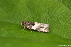
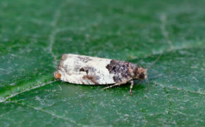
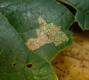
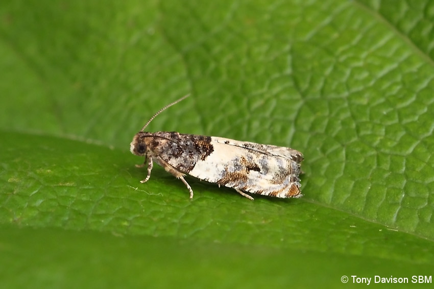

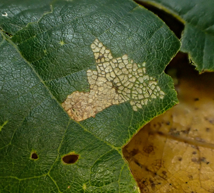
Image Gallery

Temporal Distribution Chart
Adults: (between 2004 - 2026) | Immatures: (between 2008 - 2024)
Distribution Map for Gypsonoma dealbana
↳ 17 from 2026+
↳ 46 from 2020 - 2025
↳ 45 from Before 2020
If the Map Layers function fails, just refresh the page and it should be OK after. Use the +- zoom on the top left, or on a tablet, use two fingers to zoom. Remember, the last layer you ticked is the one which displays the popup information - they sit on top of each other - de-select then re-select, to see the popup values.
Bedrock Geology ** indirectly affects moth distribution by influencing the type of habitat and food plants available in an area. In turn, this may affect the types of moths that can thrive, or where they can most likely be found.
NBN Atlas UK Distribution for – Gypsonoma dealbana
⚠️ Please wait for the map to load fully – do not click the link shown.
Note – the NBN Atlas datasets are listed in the map below and vary in their currency (uptodateness) – however,
the map does give a general indication of the moth's distribution across the UK.
Monthly Records By Year:
Gypsonoma dealbana
( data includes both Larvae and Adult Stages )
Monthly Counts By Year:
Gypsonoma dealbana
( data is based on 'Adult' stage records only )
First/Last Recorded Dates: Gypsonoma dealbana
Adult-only & Anything [Larvae, Pupae, Adult, Mines]
Shading shows moth presence between dates
Click the colour discs below to Select/De-select as Required
Recordings By Year: Gypsonoma dealbana
( All data includes both Larvae and Adult Stages )
Annual Growth Rate (AGR): Gypsonoma dealbana
AGR: -2.38% | Total % Change: -41.2%
Hectad (10kmx10km) Coverage: Gypsonoma dealbana
( data includes both Larvae and Adult Stages )
Flight Periods – Indicative –vs– Recorded Data
Gypsonoma dealbana
Gypsonoma dealbana
Flight Period chart – the grey hatched area above, which can cross one or more months, pictorially represents the best guess we have for this moth's flight periods [month/s]. The coloured lines represent the actual months seen in flight, from site observation records received between 2020-2026.
Mine Periods – Indicative –vs– Recorded Data
Gypsonoma dealbana
Gypsonoma dealbana
( data includes both Larvae and Adult Stages )
Mine Period chart – the grey hatched area above, which can cross one or more months, pictorially represents the best guess we have for this moth's mine periods [month/s]. The coloured lines represent the actual months seen mining, from site observation records received between 2020-2026.
Records Behind the Map and Charts - Gypsonoma dealbana – 108 records available
Listed by Year - descending - scroll across to see all table columns
| Site Name | Tetrad | Date | Count | Stage | Recorder | Source | RecordKey |
|---|---|---|---|---|---|---|---|
| hallcroft middleton | SK25T | 10/07/2026 | 1 | adult | Ashton, Clive | vc57_irecords_extract | iBRC54741383 |
| upper cromford garden | SK25Y | 09/07/2026 | 1 | adult | Ashton, Clive | vc57_irecords_extract | iBRC54704094 |
| DWT Wyver Lane | SK35K | 09/07/2026 | 1 | adult | Dave Evans, Dave Newcombe & Richard Taylor | vc57_irecords_extract | iBRC54735002 |
| Calke Park, Derbyshire | SK32L | 07/07/2026 | 2 | adult | Browne, Sean | vc57_irecords_extract | iBRC54638079 |
| Belper | SK34U | 07/07/2026 | 1 | adult | Evans, Dave | vc57_irecords_extract | iBRC54570450 |
| upper cromford garden | SK25Y | 06/07/2026 | 1 | adult | Ashton, Clive | vc57_irecords_extract | iBRC54548019 |
| mellor | SJ98Z | 27/06/2026 | 1 | adult | Knass, David | vc57_irecords_extract | iBRC54346039 |
| Mickleover garden | SK33C | 26/06/2026 | 1 | adult | Maughan, Christine | vc57_irecords_extract | iBRC54094915 |
| Gird Lane, Mill Brow | SJ98Z | 25/06/2026 | 5 | adult | Hind, Steve | vc57_irecords_extract | iBRC54328814 |
| Belper, Derbyshire | SK34N | 25/06/2026 | 1 | adult | Newcombe, Dave | vc57_irecords_extract | iBRC54862526 |
| Ladycroft Ave, Buxton | SK07S | 24/06/2026 | 1 | adult | Orridge, Steve | vc57_irecords_extract | iBRC54243907 |
| Chaddesden, Derby | SK33T | 24/06/2026 | 1 | adult | Roome, Martin | vc57_irecords_extract | iBRC54131779 |
| Quarndon, Derbyshire | SK34F | 24/06/2026 | 1 | adult | Pollock, Graham | vc57_irecords_extract | iBRC54077585 |
| Findern, Derbyshire | SK33A | 22/06/2026 | 1 | adult | Hallam, Brian | vc57_irecords_extract | iBRC53979030 |
| Staveley Derbyshire | SK47H | 22/06/2026 | 1 | adult | Morris, Sid | vc57_irecords_extract | iBRC53976704 |
| Spring Lakes, Nottingham | SK53B | 20/06/2026 | 1 | adult | Gregory, Neil | vc57_irecords_extract | iBRC53803962 |
| Belper, Derbyshire | SK34N | 18/06/2026 | 1 | adult | Newcombe, Dave | vc57_irecords_extract | iBRC54322635 |
| Chaddesden, Derby | SK33T | 06/09/2025 | 1 | Adult | Roome, Martin | vc57_irecords_extract | iBRC45299013 |
| Ladycroft Ave, Buxton | SK07S | 16/07/2025 | 1 | Adult | Orridge, Steve | vc57_irecords_extract | iBRC43633938 |
| Longdendale, Torside grassland and willow carr | SK09U | 13/07/2025 | 2 | Adult | Heintzen, Christian | vc57_irecords_extract | iBRC43980275 |
| Belper, Derbyshire | SK34N | 10/07/2025 | 1 | Adult | Newcombe, Dave | vc57_irecords_extract | iBRC44188242 |
| Ladycroft Ave, Buxton | SK07S | 03/07/2025 | 1 | Adult | Orridge, Steve | vc57_irecords_extract | iBRC43195720 |
| Hathersage | SK28F | 30/06/2025 | 1 | Adult | Kydd, Alan | vc57_irecords_extract | iBRC42979920 |
| Midway, Derbys. | SK32A | 30/06/2025 | 1 | Adult | Williams, Michael | vc57_irecords_extract | iBRC43042293 |
| Norton Lees, Sheffield | SK38L | 30/06/2025 | 1 | Adult | Mella, Pete | vc57_irecords_extract | iBRC42876317 |
| Mickleover garden | SK33C | 29/06/2025 | 1 | Adult | Maughan, Christine | vc57_irecords_extract | iBRC43910760 |
| Belper, Derbyshire | SK34N | 29/06/2025 | 1 | Adult | Newcombe, Dave | vc57_irecords_extract | iBRC43963669 |
| Belper, Derbyshire | SK34N | 28/06/2025 | 1 | Adult | Newcombe, Dave | vc57_irecords_extract | iBRC43963112 |
| Staveley garden SYA | SK47H | 28/06/2025 | 2 | Adult | Radford, Mark | vc57_irecords_extract | iBRC42782688 |
| Hathersage | SK28F | 27/06/2025 | 1 | Adult | Kydd, Alan | vc57_irecords_extract | iBRC42979835 |
| Woodland Ave | SK43R | 27/06/2025 | 2 | Adult | Thorpe, Steve | vc57_irecords_extract | iBRC48391169 |
| Glossop, Gnat Hole Rough Fields | SK09L | 24/06/2025 | 1 | Adult | Heintzen, Christian | vc57_irecords_extract | iBRC43979645 |
| Ingleby Ave, Derby | SK33L | 24/06/2025 | 1 | Adult | Shervill, Andrew | vc57_irecords_extract | iBRC42632801 |
| High Leas Farm | SK35D | 21/06/2025 | 3 | Adult | Thorpe, Steve | vc57_irecords_extract | iBRC48391022 |
| High Leas Farm | SK35D | 21/06/2025 | 4 | Adult | Thorpe, Steve | vc57_irecords_extract | iBRC48391082 |
| Belper, Derbyshire | SK34N | 20/06/2025 | 1 | Adult | Newcombe, Dave | vc57_irecords_extract | iBRC43959988 |
| Chaddesden Garden | SK33T | 19/06/2025 | 1 | Adult | Loverock, Neil | vc57_irecords_extract | iBRC42662410 |
| Sinfin Moor Wetlands | SK33Q | 18/06/2025 | 3 | Adult | Roome, Martin | vc57_irecords_extract | iBRC43881039 |
| Cown Edge Farm marsh | SK09A | 17/06/2025 | 1 | Adult | Heintzen, Christian | vc57_irecords_extract | iBRC43979469 |
| Pottery Wood | SK32G | 05/11/2024 | 1 | Mine | Finch, Graham Leonard | vc57_irecords_extract | iBRC41038962 |
| Burton upon Trent | SK32P | 05/11/2024 | 1 | larva | Finch, Graham Leonard | vc57_irecords_extract | iBRC41038918 |
| Derby DE | SK33I | 30/07/2024 | 1 | Adult | Watson, Adrian | vc57_irecords_extract | iBRC43689042 |
| Clover Close, Elvaston | SK43B | 29/07/2024 | 1 | Adult | Bryce, Marion | vc57_irecords_extract | iBRC38104436 |
| Inkersall garden | SK47G | 27/07/2024 | 1 | Adult | Cambridge, Don | vc57_irecords_extract | iBRC37376173 |
| upper cromford garden | SK25Y | 25/07/2024 | 1 | Adult | Ashton, Clive | vc57_irecords_extract | iBRC37484188 |
| Drakelow, Derbys. | SK22F | 22/07/2024 | 2 | Adult | Williams, Michael | vc57_irecords_extract | iBRC39954284 |
| Midway, Derbys. | SK32A | 18/07/2024 | 1 | Adult | Williams, Michael | vc57_irecords_extract | iBRC39954556 |
| South Wood | SK31U | 27/06/2024 | 15 | Adult | Roome, Martin | vc57_irecords_extract | iBRC36957476 |
| Poppy Wood | SK32S | 22/11/2023 | 1 | Mine | Finch, Graham Leonard | vc57_irecords_extract | iBRC35107074 |
| Poppy Wood | SK32S | 22/11/2023 | 1 | Mine | Finch, Graham Leonard | vc57_irecords_extract | iBRC35107075 |
| Calke Park | SK32R | 07/10/2023 | 1 | Mine | Finch, Graham Leonard | vc57_irecords_extract | iBRC35105518 |
| Calke Park | SK32R | 01/10/2023 | 1 | Larval web | Finch, Graham Leonard | vc57_irecords_extract | iBRC35105558 |
| Carver's Rocks | SK32G | 30/09/2023 | 1 | Larval web | Finch, Graham Leonard | vc57_irecords_extract | iBRC35106096 |
| Carver's Rocks | SK32G | 30/09/2023 | 1 | Larval web | Finch, Graham Leonard | vc57_irecords_extract | iBRC35106097 |
| Carver's Rocks | SK32H | 21/09/2023 | 1 | Larval case | Finch, Graham Leonard | vc57_irecords_extract | iBRC35106120 |
| Mickleover garden | SK33C | 21/06/2023 | 1 | Adult | Maughan, Christine | vc57_irecords_extract | iBRC35452289 |
| Hathersage | SK28F | 11/07/2022 | 1 | Adult | Kydd, Alan | vc57_irecords_extract | iBRC39061720 |
| Hathersage, Derbyshire, UK | SK28F | 09/06/2021 | 1 | Adult | Miles, Claire | vc57_irecords_extract | iBRC29584321 |
| Hathersage, Derbyshire, UK | SK28F | 09/06/2021 | 1 | Adult | Miles, Claire | vc57_irecords_extract | iBRC29584437 |
| Woodland Ave | SK43R | 21/07/2020 | 1 | Adult | Thorpe, Steve | vc57_irecords_extract | iBRC33501677 |
| Woodland Ave | SK43R | 06/07/2020 | 1 | Adult | Thorpe, Steve | vc57_irecords_extract | iBRC33501416 |
| Woodland Ave | SK43R | 24/06/2020 | 1 | Adult | Thorpe, Steve | vc57_irecords_extract | iBRC33501164 |
| Woodland Ave | SK43R | 14/06/2020 | 1 | Adult | Thorpe, Steve | vc57_irecords_extract | iBRC33501055 |
| Main Street, Kings Newton | SK32Y | 18/07/2018 | 1 | Adult | Soar, Will | vc57_irecords_extract | iBRC34060475 |
| Waingroves Woods | SK44E | 18/07/2018 | 1 | Adult | Thorpe, Steve | vc57_irecords_extract | iBRC33503302 |
| Shirland - Hallfieldgate Lane | SK35Z | 06/07/2017 | 1 | Adult | Mahadevan, Nikki | vc57_irecords_extract | iBRC34968417 |
| Backgarden Marehay | SK34Z | 28/07/2016 | 1 | Adult | Thorpe, Steve | vc57_irecords_extract | iBRC33504883 |
| Main Street, Kings Newton | SK32Y | 27/06/2016 | 1 | Adult | Soar, Will | vc57_irecords_extract | iBRC34060476 |
| Shirland-Hallfieldgate Lane | SK35Z | 08/08/2015 | 1 | Adult | Mahadevan, Nikki | vc57_irecords_extract | iBRC35070459 |
| Waingroves Wood Moth and Bat Event | SK44E | 08/08/2015 | 1 | Adult | Thorpe, Steve | vc57_irecords_extract | iBRC33505987 |
| Ladycroft Ave | SK07S | 07/08/2015 | 1 | Adult | Orridge, Steve | vc57_irecords_extract | iBRC48845030 |
| Backgarden Marehay | SK34Z | 10/07/2014 | 1 | Adult | Thorpe, Steve | vc57_irecords_extract | iBRC33506982 |
| Wood Lane,Newhall,Swadlincote | SK22V | 04/07/2014 | 1 | Adult | Dave Budworth | vc57_danes_bc_data | LC000334001CP0H1 |
| Not given | SK21C | 03/07/2014 | 1 | Adult | Williams, Michael | vc57_irecords_extract | iBRC1564791 |
| Melbourne, Derbyshire | SK32X | 03/07/2014 | 1 | Adult | Davison, Tony | vc57_irecords_extract | iBRC33087779 |
| Smalley Green, Heanor | SK44B | 27/06/2014 | 1 | Adult | BUDWORTH, Mr D., CLARKE, Mr D.A., PATRICK, Mr P., | vc57_danes_bc_data | LC000334001COV2M |
| Backgarden Marehay | SK34Z | 26/07/2013 | 1 | Adult | Thorpe, Steve | vc57_irecords_extract | iBRC33508835 |
| Wood Lane,Newhall,Swadlincote | SK22V | 16/07/2013 | 2 | Adult | Dave Budworth | vc57_danes_bc_data | LC000334001CP91W |
| Backgarden Marehay | SK34Z | 14/07/2013 | 1 | Adult | Thorpe, Steve | vc57_irecords_extract | iBRC33508407 |
| Wood Lane,Newhall,Swadlincote | SK22V | 12/07/2013 | 1 | Adult | Dave Budworth | vc57_danes_bc_data | LC000334001CP8ZC |
| Carr Wood | SK45A | 11/08/2012 | 1 | Adult | Thorpe, Steve | vc57_irecords_extract | iBRC33511436 |
| Carr Wood, Ripley | SK45A | 11/08/2012 | 1 | Adult | Thorpe, Steve | vc57_danes_bc_data | LC000334001CP8F6 |
| Bilberry Wood, Ambergate | SK35L | 02/08/2012 | 1 | Adult | Dave Budworth;P. Patrick | vc57_danes_bc_data | LC000334001COYBM |
| Duffield Rd, Allestree, Derby | SK34K | 27/07/2012 | 3 | Adult | P. Smith | vc57_danes_bc_data | LC000334001CP893 |
| Carr Wood | SK45A | 22/07/2012 | 3 | Adult | Thorpe, Steve | vc57_irecords_extract | iBRC33510977 |
| Carr Wood | SK45A | 22/07/2012 | 1 | Adult | Thorpe, Steve | vc57_irecords_extract | iBRC33510978 |
| Carr Wood, Ripley | SK45A | 22/07/2012 | 4 | Adult | Thorpe, Steve | vc57_danes_bc_data | LC000334001COUEG |
| Midway Rd,Midway,Swadlincote | SK32A | 07/07/2012 | 1 | Adult | M.J. Williams | vc57_danes_bc_data | LC000334001COUBI |
| Backgarden Marehay | SK34Z | 03/07/2011 | 1 | Adult | Thorpe, Steve | vc57_irecords_extract | iBRC33513292 |
| Bamford St,Ripley | SK34Z | 03/07/2011 | 1 | Adult | Thorpe, Steve | vc57_danes_bc_data | LC000334001COXQQ |
| Bamford | SK28B | 21/09/2010 | 1 | Larval Feeding Signs | K. McCabe;S.H. Hind | vc57_danes_bc_data | LC000334001CP6OF |
| Dovedale | SK15K | 30/07/2010 | 1 | Adult | D. Grundy | vc57_danes_bc_data | LC000334001COXE0 |
| Carvers Rocks area,Hartshorne | SK32G | 27/07/2010 | 1 | Adult | Dave Budworth | vc57_danes_bc_data | LC000334001CP65H |
| Carvers Rocks area (new plantation) | SK32G | 25/07/2009 | 2 | Adult | Dave Budworth | vc57_danes_bc_data | LC000334001COWUK |
| West Park Meadows (LNR),Spondon | SK33Y | 10/07/2009 | 3 | Adult | BUDWORTH, Mr D., WARD, Mr N.J., MILLAR, Mr J.C.G., | vc57_danes_bc_data | LC000334001COZAO |
| Calke Park | SK32L | 25/10/2008 | 1 | Mine | Finch, Graham Leonard | vc57_irecords_extract | iBRC35105491 |
| Calke Park,Ticknall | SK32R | 25/10/2008 | 1 | Larval Mine | VC57 Derbyshire Recorder | vc57_danes_bc_data | LC000334001COSOE |
| Carvers Rocks,Hartshorne,Swadlincote (old toilet block area) | SK32G | 11/08/2007 | 1 | Adult | A. Davison;K. Peach;N. Topliss | vc57_danes_bc_data | LC000334001COWFQ |
| Midway Rd,Midway,Swadlincote | SK32A | 24/09/2006 | 1 | Adult | M.J. Williams | vc57_danes_bc_data | LC000334001COZ85 |
| Main Street, Kings Newton | SK32Y | 11/07/2005 | 3 | Adult | Soar, Will | vc57_irecords_extract | iBRC34678031 |
| Main St,Kings Newton,Melbourne | SK32Y | 11/07/2005 | 3 | Adult | Soar, Will | vc57_danes_bc_data | LC000334001CORKI |
| Foremark Resr, Ticknall | SK32H | 09/07/2005 | 23 | Adult | A. Davison;N. Topliss;W. Soar | vc57_danes_bc_data | LC000334001CP2MR |
| Spinney Hill,Melbourne | SK32X | 01/07/2005 | 1 | Adult | Davison, Tony | vc57_danes_bc_data | LC000334001CP2KC |
| Wood Lane,Newhall,Swadlincote | SK22V | 30/07/2004 | 1 | Adult | Dave Budworth | vc57_danes_bc_data | LC000334001COVOF |
| Edgecote Drive,Newhall,Swadlincote | SK22V | 29/07/2004 | 1 | Adult | Topliss, Neil | vc57_danes_bc_data | LC000334001CP27B |
| Main Street, Kings Newton | SK32Y | 23/07/2004 | 4 | Adult | Soar, Will | vc57_irecords_extract | iBRC34678030 |
| Main St,Kings Newton,Melbourne | SK32Y | 23/07/2004 | 4 | Adult | Soar, Will | vc57_danes_bc_data | LC000334001COVNZ |
| Foremark Resr, Ticknall | SK32H | 25/06/2004 | 1 | Adult | A. Davison;N. Topliss;W. Soar | vc57_danes_bc_data | LC000334001CP1TD |