
 – click for General Verification Guidelines | – click for Specific Verification Guidelines
  – Generally Common / Widespread
  – Day-flying
Blue-coded] moths is not displayed/updated in this tab. However, all verified records for this moth are listed in the RECORDS tab below. 

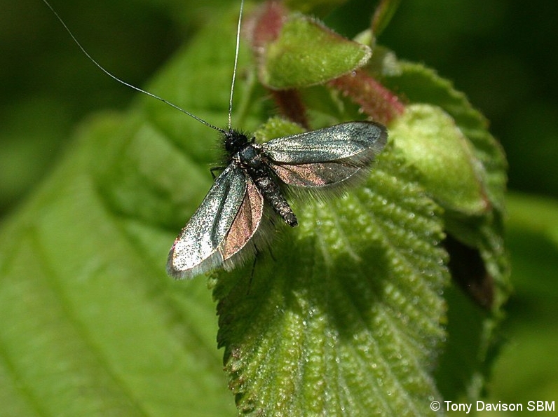
Image Gallery
Temporal Distribution Chart
Adults: (between 1979 - 2026) | Immatures: (between 2026 - 2026)
Distribution Map for Adela reaumurella
↳ 104 from 2026+
↳ 103 from 2020 - 2025
↳ 87 from Before 2020
If the Map Layers function fails, just refresh the page and it should be OK after. Use the +- zoom on the top left, or on a tablet, use two fingers to zoom. Remember, the last layer you ticked is the one which displays the popup information - they sit on top of each other - de-select then re-select, to see the popup values.
Bedrock Geology ** indirectly affects moth distribution by influencing the type of habitat and food plants available in an area. In turn, this may affect the types of moths that can thrive, or where they can most likely be found.
NBN Atlas UK Distribution for – Adela reaumurella
⚠️ Please wait for the map to load fully – do not click the link shown.
Note – the NBN Atlas datasets are listed in the map below and vary in their currency (uptodateness) – however,
the map does give a general indication of the moth's distribution across the UK.
Monthly Records By Year:
Adela reaumurella
( data includes both Larvae and Adult Stages )
Monthly Counts By Year:
Adela reaumurella
( data is based on 'Adult' stage records only )
First/Last Recorded Dates: Adela reaumurella
Adult-only & Anything [Larvae, Pupae, Adult, Mines]
Shading shows moth presence between dates
Click the colour discs below to Select/De-select as Required
Recordings By Year: Adela reaumurella
( All data includes both Larvae and Adult Stages )
Annual Growth Rate (AGR): Adela reaumurella
AGR: 5.17% | Total % Change: 235%
Hectad (10kmx10km) Coverage: Adela reaumurella
( data includes both Larvae and Adult Stages )
Flight Periods – Indicative –vs– Recorded Data
Adela reaumurella
Adela reaumurella
Flight Period chart – the grey hatched area above, which can cross one or more months, pictorially represents the best guess we have for this moth's flight periods [month/s]. The coloured lines represent the actual months seen in flight, from site observation records received between 2020-2026.
Records Behind the Map and Charts - Adela reaumurella – 294 records available
Listed by Year - descending - scroll across to see all table columns
| Site Name | Tetrad | Date | Count | Stage | Recorder | Source | RecordKey |
|---|---|---|---|---|---|---|---|
| Staunton Harold Reservoir | SK32S | 22/06/2026 | 25 | adult | Bryce, Marion | vc57_irecords_extract | iBRC53987536 |
| Manor Farm & Norfolk Road Green Space, Long Eaton - S | SK53C | 09/06/2026 | 1 | Adult | Bryce, Marion | vc57_irecords_extract | iBRC53288226 |
| Barlow | SK37C | 29/05/2026 | 1 | adult | Watchorn, Andrew | vc57_irecords_extract | iBRC53182034 |
| Buxton | SK07M | 23/05/2026 | 1 | Adult | sofiemayy22 | vc57_irecords_extract | iBRC52560606 |
| Heage | SK34P | 23/05/2026 | 1 | adult | Evans, Dave | vc57_irecords_extract | iBRC52541754 |
| Heage | SK35Q | 23/05/2026 | 1 | adult | Evans, Dave | vc57_irecords_extract | iBRC52541391 |
| Haggwater Bridge Woodland | SK18U | 21/05/2026 | 1 | adult | Hewitt, Jane | vc57_irecords_extract | iBRC52454308 |
| Middleton Moor | SK27C | 17/05/2026 | 1 | Adult | Priya Sandhu | vc57_irecords_extract | iBRC52441502 |
| Middelton Moor | SK27C | 16/05/2026 | 1 | Adult | Samuel P.C. | vc57_irecords_extract | iBRC52358819 |
| Cavendish Mill, Farnsley Ln, Stoney Middleton, Hope Valley STH, UK | SK27C | 16/05/2026 | 1 | Adult | Priya Sandhu | vc57_irecords_extract | iBRC52404921 |
| Gang Mine, Cromford | SK25X | 14/05/2026 | 1 | adult | Ashton, Clive | vc57_irecords_extract | iBRC52226063 |
| Belper | SK34P | 14/05/2026 | 1 | adult | Evans, Dave | vc57_irecords_extract | iBRC52232764 |
| DWT Wyver Lane | SK34P | 12/05/2026 | 4 | adult | Evans, Dave | vc57_irecords_extract | iBRC52178035 |
| Belper | SK34P | 11/05/2026 | 2 | adult | Evans, Dave | vc57_irecords_extract | iBRC52160044 |
| Nether Padley | SK27N | 10/05/2026 | 1 | Adult | Samuel P.C. | vc57_irecords_extract | iBRC52144105 |
| Blacka Moor | SK28Q | 10/05/2026 | 1 | adult | Albarella, Umberto | vc57_irecords_extract | iBRC52228445 |
| Heage | SK34U | 10/05/2026 | 1 | adult | Evans, Dave | vc57_irecords_extract | iBRC52131435 |
| Gleadless Valley LNR | SK38R | 10/05/2026 | 1 | adult | Mella, Pete | vc57_irecords_extract | iBRC52132109 |
| Heage | SK34P | 09/05/2026 | 3 | adult | Evans, Dave | vc57_irecords_extract | iBRC52100010 |
| Heage | SK34U | 09/05/2026 | 1 | adult | Evans, Dave | vc57_irecords_extract | iBRC52099332 |
| Heage | SK34U | 09/05/2026 | 2 | adult | Evans, Dave | vc57_irecords_extract | iBRC52099708 |
| Heage | SK35Q | 09/05/2026 | 2 | adult | Evans, Dave | vc57_irecords_extract | iBRC52099917 |
| Forbes Hole LNR, Long Eaton - S | SK43W | 09/05/2026 | 4 | Adult | Bryce, Marion | vc57_irecords_extract | iBRC52217716 |
| Cromford Moor | SK25X | 08/05/2026 | 5 | adult | Ashton, Clive | vc57_irecords_extract | iBRC52085214 |
| Heage | SK34U | 08/05/2026 | 1 | adult | Evans, Dave | vc57_irecords_extract | iBRC52072264 |
| Heage | SK34U | 08/05/2026 | 2 | adult | Evans, Dave | vc57_irecords_extract | iBRC52072612 |
| Holloway Fields - S | SK35I | 08/05/2026 | 7 | Adult | Pritchard, Alison | vc57_irecords_extract | iBRC52690433 |
| Belper | SK34P | 07/05/2026 | 1 | adult | Evans, Dave | vc57_irecords_extract | iBRC52040284 |
| Cromford Moor | SK25X | 06/05/2026 | 6 | adult | Ashton, Clive | vc57_irecords_extract | iBRC52032171 |
| DWT Wyver Lane | SK34P | 06/05/2026 | 1 | adult | Evans, Dave | vc57_irecords_extract | iBRC52026518 |
| DWT Wyver Lane | SK34P | 06/05/2026 | 5 | adult | Evans, Dave | vc57_irecords_extract | iBRC52026905 |
| DWT Wyver Lane | SK34P | 06/05/2026 | 1 | adult | Evans, Dave | vc57_irecords_extract | iBRC52036358 |
| Pinewood Road, Matlock | SK26V | 05/05/2026 | 1 | Adult | rose862 | vc57_irecords_extract | iBRC52013924 |
| Ramsley Reservoir | SK27X | 05/05/2026 | 1 | Adult | Trevor Marshall | vc57_irecords_extract | iBRC52347517 |
| Belper | SK34P | 05/05/2026 | 2 | adult | Evans, Dave | vc57_irecords_extract | iBRC51995506 |
| Sydnope, Matlock | SK26X | 04/05/2026 | 1 | Adult | Nadine | vc57_irecords_extract | iBRC51987921 |
| Nine Ladies, Stanton Moor | SK26L | 02/05/2026 | 1 | Adult | Vosper, Matthew | vc57_irecords_extract | iBRC53141020 |
| Heage | SK34U | 02/05/2026 | 2 | adult | Evans, Dave | vc57_irecords_extract | iBRC51918344 |
| Heage | SK34U | 02/05/2026 | 1 | adult | Evans, Dave | vc57_irecords_extract | iBRC51937562 |
| Heage | SK34U | 02/05/2026 | 1 | adult | Evans, Dave | vc57_irecords_extract | iBRC51937681 |
| Dore & Totley Golf Club | SK38F | 02/05/2026 | 1 | Adult | Samuel P.C. | vc57_irecords_extract | iBRC51926512 |
| Dore & Totley Golf Club | SK38F | 02/05/2026 | 1 | Adult | Samuel P.C. | vc57_irecords_extract | iBRC51926513 |
| Dore & Totley Golf Course | SK38F | 02/05/2026 | 1 | Adult | Samuel P.C. | vc57_irecords_extract | iBRC52347516 |
| Nether Padley, Grindleford, Hope Valley SHE, UK | SK27P | 01/05/2026 | 1 | Adult | Saunders, Adam | vc57_irecords_extract | iBRC51901725 |
| Heage | SK34P | 01/05/2026 | 1 | adult | Evans, Dave | vc57_irecords_extract | iBRC51891058 |
| Heage | SK34U | 01/05/2026 | 1 | adult | Evans, Dave | vc57_irecords_extract | iBRC51890517 |
| Heage | SK34U | 01/05/2026 | 2 | adult | Evans, Dave | vc57_irecords_extract | iBRC51890684 |
| Heage | SK34U | 01/05/2026 | 2 | adult | Evans, Dave | vc57_irecords_extract | iBRC51890937 |
| Heage | SK35Q | 01/05/2026 | 3 | adult | Evans, Dave | vc57_irecords_extract | iBRC51891002 |
| Dennis Knoll, Hathersage | SK28H | 30/04/2026 | 1 | adult | Bell, Steven | vc57_irecords_extract | iBRC51845460 |
| DWT Wyver Lane | SK34P | 30/04/2026 | 2 | adult | Evans, Dave | vc57_irecords_extract | iBRC51833020 |
| DWT Wyver Lane | SK34P | 30/04/2026 | 1 | adult | Evans, Dave | vc57_irecords_extract | iBRC51833100 |
| DWT Wyver Lane | SK34P | 30/04/2026 | 1 | adult | Evans, Dave | vc57_irecords_extract | iBRC51833289 |
| DWT Wyver Lane | SK34P | 30/04/2026 | 2 | adult | Evans, Dave | vc57_irecords_extract | iBRC51833476 |
| Upper Padley | SK27P | 29/04/2026 | 1 | Adult | argus56 | vc57_irecords_extract | iBRC51813293 |
| DWT Wyver Lane | SK34P | 29/04/2026 | 3 | adult | Evans, Dave | vc57_irecords_extract | iBRC51812033 |
| DWT Wyver Lane | SK34P | 29/04/2026 | 7 | adult | Evans, Dave | vc57_irecords_extract | iBRC51812398 |
| DWT Wyver Lane | SK34P | 29/04/2026 | 4 | adult | Evans, Dave | vc57_irecords_extract | iBRC51812508 |
| DWT Wyver Lane | SK34P | 29/04/2026 | 2 | adult | Evans, Dave | vc57_irecords_extract | iBRC51812783 |
| Hathersage, Derbyshire | SK28F | 27/04/2026 | 10 | adult | Butlin, Roger | vc57_irecords_extract | iBRC51750981 |
| Crich Lane | SK34P | 27/04/2026 | 2 | adult | Evans, Dave | vc57_irecords_extract | iBRC51753358 |
| Crich Lane | SK34P | 27/04/2026 | 1 | adult | Evans, Dave | vc57_irecords_extract | iBRC51753427 |
| Padley Gorge | SK27P | 26/04/2026 | 1 | adult | Beth Clayton | vc57_irecords_extract | iBRC51714619 |
| Heage | SK34U | 26/04/2026 | 1 | adult | Evans, Dave | vc57_irecords_extract | iBRC51710855 |
| Lea, Derbyshire | SK35D | 26/04/2026 | 10 | adult | Hamish Rogers | vc57_irecords_extract | iBRC51796552 |
| Heage | SK35Q | 25/04/2026 | 3 | adult | Evans, Dave | vc57_irecords_extract | iBRC51689693 |
| Hall Lane Pond | SK47H | 24/04/2026 | 48 | adult | Radford, Mark | vc57_irecords_extract | iBRC51651732 |
| Shire Brook Valley Nature Reserve | SK48C | 24/04/2026 | 15 | adult | Turner, Andrea | vc57_irecords_extract | iBRC51686500 |
| Heage | SK34P | 23/04/2026 | 2 | adult | Evans, Dave | vc57_irecords_extract | iBRC51641650 |
| Heage | SK34U | 23/04/2026 | 2 | adult | Evans, Dave | vc57_irecords_extract | iBRC51641595 |
| Heage | SK34U | 23/04/2026 | 1 | pupa | Evans, Dave | vc57_irecords_extract | iBRC51641596 |
| Heage | SK34U | 23/04/2026 | 1 | adult | Evans, Dave | vc57_irecords_extract | iBRC51641913 |
| Heage | SK35K | 23/04/2026 | 5 | adult | Evans, Dave | vc57_irecords_extract | iBRC51641645 |
| Heage | SK35Q | 23/04/2026 | 2 | adult | Evans, Dave | vc57_irecords_extract | iBRC51641631 |
| Jim Mart Nature Reserve, Press Ln, Nr Ashover | SK36S | 23/04/2026 | 1 | adult | Mahadevan, Nikki | vc57_irecords_extract | iBRC51703774 |
| Chaddesdon wood | SK33Z | 22/04/2026 | 10 | adult | Bryce, Marion | vc57_irecords_extract | iBRC51601657 |
| DWT Wyver Lane | SK34P | 22/04/2026 | 2 | adult | Evans, Dave | vc57_irecords_extract | iBRC51608925 |
| DWT Wyver Lane | SK34P | 22/04/2026 | 3 | adult | Evans, Dave | vc57_irecords_extract | iBRC51609105 |
| DWT Wyver Lane | SK34P | 22/04/2026 | 2 | adult | Evans, Dave | vc57_irecords_extract | iBRC51609128 |
| DWT Wyver Lane | SK34P | 22/04/2026 | 2 | adult | Evans, Dave | vc57_irecords_extract | iBRC51609148 |
| DWT Wyver Lane | SK34P | 22/04/2026 | 7 | adult | Evans, Dave | vc57_irecords_extract | iBRC51609162 |
| DWT Wyver Lane | SK34P | 22/04/2026 | 5 | adult | Evans, Dave | vc57_irecords_extract | iBRC51609178 |
| DWT Wyver Lane | SK34P | 22/04/2026 | 6 | adult | Evans, Dave | vc57_irecords_extract | iBRC51609195 |
| DWT Wyver Lane | SK34P | 22/04/2026 | 3 | adult | Evans, Dave | vc57_irecords_extract | iBRC51609203 |
| DWT Wyver Lane | SK34P | 22/04/2026 | 4 | adult | Evans, Dave | vc57_irecords_extract | iBRC51609214 |
| DWT Wyver Lane | SK34P | 22/04/2026 | 2 | adult | Evans, Dave | vc57_irecords_extract | iBRC51609559 |
| DWT Wyver Lane | SK34P | 22/04/2026 | 1 | adult | Evans, Dave | vc57_irecords_extract | iBRC51609660 |
| DWT Wyver Lane | SK34P | 22/04/2026 | 2 | adult | Evans, Dave | vc57_irecords_extract | iBRC51609750 |
| Crich Lane - Belper | SK34P | 21/04/2026 | 2 | adult | Evans, Dave | vc57_irecords_extract | iBRC51582517 |
| Hang Bank woods | SK38S | 21/04/2026 | 4 | Adult | Charlie Hill /Nature Natter group participants | vc57_irecords_extract | iBRC51605251 |
| Heage | SK34U | 20/04/2026 | 2 | adult | Evans, Dave | vc57_irecords_extract | iBRC51577989 |
| Gleadless Valley LNR | SK38L | 20/04/2026 | 2 | adult | Mella, Pete | vc57_irecords_extract | iBRC51572384 |
| Heage | SK34P | 19/04/2026 | 4 | adult | Evans, Dave | vc57_irecords_extract | iBRC51538707 |
| Graves Park | SK38L | 19/04/2026 | 1 | adult | Mella, Pete | vc57_irecords_extract | iBRC51571670 |
| Markham Vale South Tip | SK47K | 19/04/2026 | 9 | adult | Radford, Mark | vc57_irecords_extract | iBRC51550505 |
| Heage | SK35K | 18/04/2026 | 5 | adult | Evans, Dave | vc57_irecords_extract | iBRC51516507 |
| Chancet Wood | SK38K | 18/04/2026 | 1 | adult | Mella, Pete | vc57_irecords_extract | iBRC51547120 |
| Foxstone Wood | SK47I | 17/04/2026 | 19 | adult | Radford, Mark | vc57_irecords_extract | iBRC51506291 |
| DWT Wyver Lane | SK34P | 16/04/2026 | 1 | adult | Evans, Dave | vc57_irecords_extract | iBRC51492160 |
| Heage | SK34U | 16/04/2026 | 1 | adult | Evans, Dave | vc57_irecords_extract | iBRC51498919 |
| Heage | SK35K | 16/04/2026 | 2 | adult | Evans, Dave | vc57_irecords_extract | iBRC51498981 |
| Cromford Canal | SK35H | 13/04/2026 | 2 | adult | Evans, Dave | vc57_irecords_extract | iBRC51446054 |
| heage | SK34U | 12/04/2026 | 1 | adult | Evans, Dave | vc57_irecords_extract | iBRC51446013 |
| Heage | SK35K | 10/04/2026 | 2 | adult | Evans, Dave | vc57_irecords_extract | iBRC51415771 |
| North Lees Estate, Hathersage | SK28G | 29/05/2025 | 5 | Adult | Watchorn, Andrew | vc57_irecords_extract | iBRC43528296 |
| Burrs Wood, Holmesfield CP | SK37C | 29/05/2025 | 1 | Adult | Alder, Jim | vc57_irecords_extract | iBRC41922143 |
| DWT Wyver Lane | SK34P | 20/05/2025 | 3 | Adult | Evans, Dave | vc57_irecords_extract | iBRC41723951 |
| Chapel-en-le-Frith, High Peak, England, GB | SK07P | 19/05/2025 | 1 | Adult | Murdoch, Sue | vc57_irecords_extract | iBRC46909236 |
| Buxton: Flint Clough | SK07M | 18/05/2025 | 3 | Adult | Harvey, Martin C. | vc57_irecords_extract | iBRC41755401 |
| Moss Valley Meadows (NT) | SK38V | 18/05/2025 | 1 | Adult | Horsfall, Jim | vc57_irecords_extract | iBRC41661143 |
| Glossop, Chunal Moor | SK09K | 16/05/2025 | 10 | Adult | Heintzen, Christian | vc57_irecords_extract | iBRC43979155 |
| Bamford Edge | SK28C | 16/05/2025 | 1 | Adult | jhall3 | vc57_irecords_extract | iBRC46909237 |
| Burbage Valley | SK28Q | 16/05/2025 | 40 | Adult | Butterfield, Roger | vc57_irecords_extract | iBRC41623625 |
| Ridge Lodge, Chapel-en-le-Frith | SK07P | 13/05/2025 | 1 | Adult | Murdoch, Sue | vc57_irecords_extract | iBRC41614457 |
| DWT Wyver Lane | SK34P | 13/05/2025 | 3 | Adult | Evans, Dave | vc57_irecords_extract | iBRC41552720 |
| Longdendale, Torside, Transpennine Trail | SK09U | 12/05/2025 | 5 | Adult | Heintzen, Christian | vc57_irecords_extract | iBRC43979103 |
| Blacka Moor | SK28Q | 10/05/2025 | 1 | Adult | Albarella, Umberto | vc57_irecords_extract | iBRC45155684 |
| Graves Park, Sheffield | SK38L | 10/05/2025 | 1 | Adult | Mella, Pete | vc57_irecords_extract | iBRC46909227 |
| Baslow Edge | SK27R | 08/05/2025 | 1 | Adult | Scott, Aileen | vc57_irecords_extract | iBRC46909232 |
| Markham Vale North Tip | SK47L | 07/05/2025 | 50 | Adult | Radford, Mark | vc57_irecords_extract | iBRC41438826 |
| Calke,Southwood | SK32Q | 06/05/2025 | 1 | Adult | Bell, Melinda | vc57_irecords_extract | iBRC41415107 |
| DWT Wyver Lane | SK34P | 06/05/2025 | 5 | Adult | Evans, Dave | vc57_irecords_extract | iBRC41397955 |
| Buxton, England, GB | SK07M | 03/05/2025 | 1 | Adult | Louise Moon | vc57_irecords_extract | iBRC41448976 |
| Glossop, Moorfield, Wood's Cabin | SK09L | 02/05/2025 | 1 | Adult | Heintzen, Christian | vc57_irecords_extract | iBRC43978996 |
| LUDWORTH MOOR | SJ99V | 01/05/2025 | 20 | Adult | BISSITT, ANDREW | vc57_irecords_extract | iBRC41988211 |
| DWT Wyver Lane | SK34P | 29/04/2025 | 3 | Adult | Evans, Dave | vc57_irecords_extract | iBRC41247288 |
| Gleadless Valley LNR (land near Newfield School) | SK38L | 28/04/2025 | 1 | Adult | Mella, Pete | vc57_irecords_extract | iBRC41210544 |
| Gleadless Valley LNR (land near Newfield School) | SK38L | 28/04/2025 | 1 | Adult | Mella, Pete | vc57_irecords_extract | iBRC41210545 |
| Combes Wood | SK35D | 27/04/2025 | 4 | Adult | Mahadevan, Nikki | vc57_irecords_extract | iBRC41212192 |
| DWT Wyver Lane | SK34P | 29/05/2024 | 3 | Adult | Evans, Dave | vc57_irecords_extract | iBRC36168586 |
| DWT Wyver Lane | SK34P | 29/05/2024 | 3 | Adult | Evans, Dave | vc57_irecords_extract | iBRC36168597 |
| DWT Wyver Lane | SK34P | 21/05/2024 | 1 | Adult | Evans, Dave | vc57_irecords_extract | iBRC36041842 |
| DWT Wyver Lane | SK34P | 15/05/2024 | 2 | Adult | Evans, Dave | vc57_irecords_extract | iBRC35931096 |
| Baslow edge | SK27L | 12/05/2024 | 1 | Adult | Stirrups , Jessica | vc57_irecords_extract | iBRC35900775 |
| Short Edge | SK07U | 11/05/2024 | 20 | Adult | Whiteley, Derek | vc57_irecords_extract | iBRC39179981 |
| Hope, Hope Valley SZE, UK | SK18X | 11/05/2024 | 1 | Adult | Judy Lo | vc57_irecords_extract | iBRC36132477 |
| Burbage Valley | SK28Q | 11/05/2024 | 1 | Adult | aileenscott | vc57_irecords_extract | iBRC35881009 |
| Gleadless Valley LNR, Sheffield, UK | SK38R | 11/05/2024 | 1 | Adult | Mella, Pete | vc57_irecords_extract | iBRC35851438 |
| Quarry Road, Birch Vale | SK08D | 10/05/2024 | 1 | Adult | dogwalknaturespot | vc57_irecords_extract | iBRC35834508 |
| DWT Wyver Lane | SK34P | 09/05/2024 | 1 | Adult | Evans, Dave | vc57_irecords_extract | iBRC35828175 |
| Hearthstone Lane, Derbyshire | SK35D | 06/05/2024 | 20 | Adult | Pritchard, Alison | vc57_irecords_extract | iBRC35777662 |
| Beeley, Derbyshire | SK26Y | 05/05/2024 | 1 | Adult | Kirsty Raphael | vc57_irecords_extract | iBRC35748837 |
| Sheffield, UK | SK28Q | 05/05/2024 | 1 | Adult | aileenscott | vc57_irecords_extract | iBRC35765160 |
| Blacka Moor | SK28V | 05/05/2024 | 2 | Adult | Higginson-Tranter, Dave | vc57_irecords_extract | iBRC35811101 |
| Diamond Dr, Derby, England, GB | SK33Z | 04/05/2024 | 1 | Adult | heatheroakwood | vc57_irecords_extract | iBRC35731610 |
| ETHEROW COUNTRY PARK | SJ99Q | 02/05/2024 | 3 | Adult | BISSITT, ANDREW | vc57_irecords_extract | iBRC36153234 |
| Glossop, Bray Clough | SK09K | 01/05/2024 | 1 | Adult | Heintzen, Christian | vc57_irecords_extract | iBRC36371560 |
| DWT Wyver Lane | SK34P | 30/04/2024 | 5 | Adult | Evans, Dave | vc57_irecords_extract | iBRC35665553 |
| Red river | SK44I | 30/04/2024 | 3 | Adult | Bryce, Marion | vc57_irecords_extract | iBRC35720231 |
| Glossop, Shire Hill, south | SK09M | 27/04/2024 | 1 | Adult | Heintzen, Christian | vc57_irecords_extract | iBRC36371539 |
| belper coppice park | SK34N | 27/04/2024 | 1 | Adult | Bryce, Marion | vc57_irecords_extract | iBRC35608062 |
| Coalpit Wood | SK38Q | 21/04/2024 | 1 | Adult | Herrera Grau, Amalia | vc57_irecords_extract | iBRC35546622 |
| Newfield Spring Wood | SK38Q | 19/04/2024 | 1 | Adult | Whiteley, Derek | vc57_irecords_extract | iBRC35755508 |
| Carterhall wood | SK38V | 19/04/2024 | 1 | Adult | Horsfall, Jim | vc57_irecords_extract | iBRC35451096 |
| Bolehill Wood, Sheffield | SK38L | 14/04/2024 | 1 | Adult | Mella, Pete | vc57_irecords_extract | iBRC35530355 |
| Grinlow Woods (west), Derbyshire | SK07L | 09/06/2023 | 1 | Adult | Mortin, Jon | vc57_irecords_extract | iBRC30778721 |
| Longshaw, National Trust estate | SK28Q | 26/05/2023 | 6 | Adult | Allnatt, Gina | vc57_irecords_extract | iBRC30520770 |
| Stoney Cloud ancient woodland | SK43T | 20/05/2023 | 20 | Adult | Penson, Melanie | vc57_irecords_extract | iBRC30415234 |
| Beeley to Rowsley | SK26T | 19/05/2023 | 1 | Adult | Watchorn, Andrew | vc57_irecords_extract | iBRC30525009 |
| DWT Wyver Lane | SK34P | 16/05/2023 | 1 | Adult | Evans, Dave | vc57_irecords_extract | iBRC35314793 |
| Ramsley reservoir | SK27X | 15/05/2023 | 100 | Adult | Stirrups , Jessica | vc57_irecords_extract | iBRC30335484 |
| Derbyshire, UK | SK37J | 15/05/2023 | 1 | Adult | Trevor Marshall | vc57_irecords_extract | iBRC30334929 |
| Ladygrove, Belper DEJS, UK | SK35R | 14/05/2023 | 1 | Adult | Anderson, Denver | vc57_irecords_extract | iBRC30319849 |
| Coal Aston, Moss Valley | SK37U | 14/05/2023 | 20 | Adult | McLean, Angela | vc57_irecords_extract | iBRC30318333 |
| Toton Sidings | SK43X | 14/05/2023 | 2 | Adult | Bryce, Marion | vc57_irecords_extract | iBRC30324591 |
| Longdendale, Woodhead Trail | SK09Z | 13/05/2023 | 10 | Adult | Heintzen, Christian | vc57_irecords_extract | iBRC36335936 |
| Big Moor and Barbrook | SK27Y | 13/05/2023 | 1 | Adult | Watchorn, Andrew | vc57_irecords_extract | iBRC30386162 |
| West Park Fox Covert LNR | SK43W | 13/05/2023 | 1 | Adult | Bryce, Marion | vc57_irecords_extract | iBRC30342707 |
| Glossop, Shire Hill, south | SK09M | 09/05/2023 | 2 | Adult | Heintzen, Christian | vc57_irecords_extract | iBRC36335912 |
| Wickfield Plantation | SK48C | 09/05/2023 | 2 | Adult | Shaw, Roger | vc57_irecords_extract | iBRC30282080 |
| Station Road Upper Padley Grindleford | SK27P | 05/05/2023 | 1 | Adult | Pugh, S | vc57_irecords_extract | iBRC45332588 |
| Gillifield Wood | SK37E | 04/05/2023 | 1 | Adult | Stirrups , Jessica | vc57_irecords_extract | iBRC30199067 |
| Glossop, Hague Street, Hay meadow | SK09G | 01/05/2023 | 1 | Adult | Heintzen, Christian | vc57_irecords_extract | iBRC36335860 |
| Sheffield, UK | SK28W | 26/05/2022 | 1 | Adult | Orridge, Steve | vc57_irecords_extract | iBRC28580580 |
| Limb Valley | SK38B | 26/05/2022 | 1 | Adult | Whiteley, Derek | vc57_irecords_extract | iBRC43789592 |
| Derbyshire, England, GB | SK32L | 20/05/2022 | 1 | Adult | Clare Lusher | vc57_irecords_extract | iBRC25442023 |
| Grinlow Woods, Derbyshire, UK | SK07L | 19/05/2022 | 1 | Adult | Mortin, Jon | vc57_irecords_extract | iBRC32515904 |
| Peak District National Park, Matlock, England, GB | SK26V | 15/05/2022 | 1 | Adult | izzydewhat | vc57_irecords_extract | iBRC25382169 |
| Carr Vale/Peter Fidler NR | SK47K | 15/05/2022 | 1 | Adult | Higginson-Tranter, Dave | vc57_irecords_extract | iBRC25393604 |
| Toton Sidings | SK43X | 13/05/2022 | 1 | Adult | Penson, Melanie | vc57_irecords_extract | iBRC25350615 |
| Toton Sidings, Notts | SK43X | 13/05/2022 | 1 | Adult | Penson, Melanie | vc57_irecords_extract | iBRC29379320 |
| Toton Sidings | SK43X | 10/05/2022 | 12 | Adult | Bryce, Marion | vc57_irecords_extract | iBRC25305978 |
| Birch Vale | SK08I | 07/05/2022 | 2 | Adult | Hewitt, Jane | vc57_irecords_extract | iBRC34105861 |
| Peak District National Park, Glossop, England, GB | SK09M | 05/05/2022 | 1 | Adult | spiderman_77 | vc57_irecords_extract | iBRC25190918 |
| Ladybower Wood, Bamford SBY, UK | SK28D | 01/05/2022 | 1 | Adult | Waterman, Helen | vc57_irecords_extract | iBRC25340223 |
| Birch Vale | SK08I | 10/06/2021 | 1 | Adult | Hewitt, Jane | vc57_irecords_extract | iBRC34472073 |
| Peak District National Park, Matlock, England, GB | SK26F | 10/06/2021 | 1 | Adult | William Stephens | vc57_irecords_extract | iBRC22721974 |
| Hillbridge Nature Reserve | SK07E | 04/06/2021 | 1 | Adult | Hewitt, Jane | vc57_irecords_extract | iBRC23564024 |
| Blacka Moor | SK28V | 30/05/2021 | 20 | Adult | Higginson-Tranter, Dave | vc57_irecords_extract | iBRC20537313 |
| Drakelow, Derbys. | SK22F | 19/05/2021 | 15 | Adult | Williams, Michael | vc57_irecords_extract | iBRC38493939 |
| UK, Derbyshire, Holloway Memorial Ground | SK35I | 13/05/2021 | 1 | Adult | Miles, Claire | vc57_irecords_extract | iBRC29303621 |
| Bradley Wood | SK24D | 12/05/2021 | 1 | Adult | Docker, Steve | vc57_irecords_extract | iBRC23626416 |
| Combs Moss | SK07I | 31/05/2020 | 1 | Adult | Whiteley, Derek | vc57_irecords_extract | iBRC20386082 |
| Combs Edge | SK07N | 30/05/2020 | 1 | Adult | Whiteley, Derek | vc57_irecords_extract | iBRC15197305 |
| Birch Vale | SK08I | 21/05/2020 | 10 | Adult | Hewitt, Jane | vc57_irecords_extract | iBRC35067582 |
| Jim Mart Nature Reserve | SK36S | 18/05/2020 | 1 | Adult | Mahadevan, Nikki | vc57_irecords_extract | iBRC34919199 |
| Birch Vale | SK08I | 17/05/2020 | 2 | Adult | Hewitt, Jane | vc57_irecords_extract | iBRC35067569 |
| Derbyshire, UK | SK45J | 15/05/2020 | 1 | Adult | arthurolive | vc57_irecords_extract | iBRC25521995 |
| Coombes Rocks | SK09A | 14/05/2020 | 1 | Adult | Marriott, Antony | vc57_irecords_extract | iBRC13439865 |
| Mellor Moor | SJ98Y | 09/05/2020 | 450 | Adult | BISSITT, ANDREW | vc57_irecords_extract | iBRC13389837 |
| Birch Vale | SK08I | 09/05/2020 | 12 | Adult | Hewitt, Jane | vc57_irecords_extract | iBRC35067552 |
| Birch Vale | SK08I | 07/05/2020 | 1 | Adult | Hewitt, Jane | vc57_irecords_extract | iBRC35067551 |
| Greaves Piece | SK27Y | 07/05/2020 | 1 | Adult | Whiteley, Derek | vc57_irecords_extract | iBRC14289148 |
| Stoney Clouds | SK43T | 07/05/2020 | 10 | Adult | Bryce, Marion | vc57_irecords_extract | iBRC13363791 |
| Jim Mart Nature Reserve | SK36S | 06/05/2020 | 1 | Adult | Mahadevan, Nikki | vc57_irecords_extract | iBRC34919190 |
| Birch Vale | SK08I | 03/05/2020 | 1 | Adult | Hewitt, Jane | vc57_irecords_extract | iBRC35067547 |
| Moss Valley Woodlands | SK38Q | 21/04/2020 | 1 | Adult | Wendy Birks | vc57_irecords_extract | iBRC13249425 |
| kedlestone hay wood | SK34A | 15/07/2019 | 1 | Adult | nick brown | vc57_irecords_extract | iBRC12472965 |
| Blacka Moor and Plantation | SK28V | 01/06/2019 | 1 | Adult | Watchorn, Andrew | vc57_irecords_extract | iBRC10937812 |
| Derbyshire, UK | SJ98X | 31/05/2019 | 1 | Adult | Mortin, Jon | vc57_irecords_extract | iBRC38133681 |
| Shillito Wood | SK27X | 31/05/2019 | 1 | Adult | Watchorn, Andrew | vc57_irecords_extract | iBRC10821583 |
| Sheffield SJP, UK | SK38R | 25/05/2019 | 1 | Adult | Mella, Pete | vc57_irecords_extract | iBRC10248702 |
| Jim Mart Nature Reserve | SK36S | 23/05/2019 | 1 | Adult | Mahadevan, Nikki | vc57_irecords_extract | iBRC34919009 |
| Errwood/Fernilee Reservoirs | SK07C | 19/05/2019 | 2 | other | Higginson-Tranter, Dave | vc57_irecords_extract | iBRC10187486 |
| Swadlincote | SK21Z | 14/05/2019 | 1 | Adult | Shaw, Lee | vc57_irecords_extract | iBRC13856695 |
| Jim Mart Nature Reserve | SK36S | 14/05/2019 | 1 | Adult | Mahadevan, Nikki | vc57_irecords_extract | iBRC34919007 |
| Jordanthorpe Green, Sheffield, England, GB | SK38Q | 12/05/2019 | 1 | Adult | toastedspoon | vc57_irecords_extract | iBRC10190300 |
| Peak District National Park, Sheffield, England, GB | SK28V | 07/05/2019 | 1 | Adult | toastedspoon | vc57_irecords_extract | iBRC10077596 |
| kedleston hay wood | SK34A | 01/05/2019 | 100 | Adult | nick brown | vc57_irecords_extract | iBRC10373394 |
| Toton Sidings | SK43X | 01/05/2019 | 1 | Adult | Bryce, Marion | vc57_irecords_extract | iBRC10022792 |
| Lea Gardens, Lea, Derbyshire | SK35I | 28/04/2019 | 10 | Adult | Miles, Claire | vc57_irecords_extract | iBRC12721174 |
| Pioneer Meadows LNR | SK43P | 02/06/2018 | 1 | Adult | Bryce, Marion | vc57_irecords_extract | iBRC6882172 |
| Green Clough | SK19K | 23/05/2018 | 1 | Adult | Whiteley, Derek | vc57_irecords_extract | iBRC10060002 |
| Green Clough | SK19L | 23/05/2018 | 1 | Adult | Whiteley, Derek | vc57_irecords_extract | iBRC10060003 |
| Blacka Moor | SK28V | 19/05/2018 | 9 | Adult | Soames, Barry | vc57_irecords_extract | iBRC6823967 |
| Moss Valley Woodlands Nature Reserve | SK38Q | 19/05/2018 | 20 | Adult | Birks, Wendy | vc57_irecords_extract | iBRC6792793 |
| Lantern Pike, Hayfield | SK08I | 18/05/2018 | 100 | Adult | Hewitt, Jane | vc57_irecords_extract | iBRC40105811 |
| Lightwood Reservoir, Buxon | SK07M | 16/05/2018 | 1 | Adult | Hewitt, Jane | vc57_irecords_extract | iBRC40107310 |
| Birch Vale | SK08I | 16/05/2018 | 1 | Adult | Hewitt, Jane | vc57_irecords_extract | iBRC40107289 |
| Birch Vale | SK08I | 13/05/2018 | 1 | Adult | Hewitt, Jane | vc57_irecords_extract | iBRC40107287 |
| West Park Fox Covert LNR | SK43W | 12/05/2018 | 1 | Adult | Bryce, Marion | vc57_irecords_extract | iBRC6752347 |
| Ashover, Derbyshire | SK36L | 09/05/2018 | 13 | Adult | Plant, Stephen | vc57_irecords_extract | iBRC12936671 |
| Gleadless Valley LNR | SK38L | 07/05/2018 | 1 | Adult | Mella, Pete | vc57_irecords_extract | iBRC6728792 |
| Norton Lees, Sheffield, UK | SK38L | 07/05/2018 | 1 | Adult | Mella, Pete | vc57_irecords_extract | iBRC9913159 |
| Stanton Iron Works | SK43U | 07/05/2018 | 10 | Adult | Huskisson, Derek | vc57_irecords_extract | iBRC6746598 |
| Birch Vale | SK08I | 02/05/2017 | 1 | Adult | Hewitt, Jane | vc57_irecords_extract | iBRC40501183 |
| Lightwood | SK07M | 24/05/2016 | 11 | Adult | Orridge, Steve | vc57_irecords_extract | iBRC41052282 |
| Ashover, Derbyshire | SK36L | 07/05/2016 | 7 | Adult | Plant, Stephen | vc57_irecords_extract | iBRC12915828 |
| Markham Vale, Derbyshire | SK47L | 07/05/2016 | 1 | Adult | Radford, Mark | vc57_irecords_extract | iBRC3117931 |
| Derbyshire, UK | SK07M | 05/06/2015 | 1 | Adult | Orridge, Steve | vc57_irecords_extract | iBRC22503796 |
| Jim Mart Nature Reserve | SK36S | 27/05/2015 | 1 | Adult | Mahadevan, Nikki | vc57_irecords_extract | iBRC34907975 |
| Carr Vale NR,Bolsover | SK46P | 19/04/2015 | 1 | Adult | VC57 Derbyshire Recorder | vc57_danes_bc_data | LC000334001CP9N0 |
| Brushfield Spar Quarry, Monsal Dale, Little Longstone | SK17Q | 17/05/2014 | 2 | Adult | Dave Budworth | vc57_danes_bc_data | LC000334001CP0FF |
| Robin Wood, Ticknall | SK32N | 19/05/2013 | 1 | Adult | Dave Budworth | vc57_danes_bc_data | LC000334001CP8TI |
| Jim Mart Nature Reserve | SK36S | 19/05/2013 | 1 | Adult | Mahadevan, Nikki | vc57_irecords_extract | iBRC34906402 |
| Crich Chase,Ambergate | SK35L | 09/06/2012 | 1 | Adult | K.R. Huston | vc57_danes_bc_data | LC000334001COY2W |
| Buckland Hollow (disused railway), Ambergate | SK35R | 22/05/2012 | 1 | Adult | K.R. Huston | vc57_danes_bc_data | LC000334001COY20 |
| Owlthorpe, Mosbrough | SK48B | 22/05/2012 | 1 | Adult | D. Whiteley | vc57_danes_bc_data | LC000334001COY2D |
| Jackson's Ln | SK34U | 21/05/2012 | 1 | Adult | sparky | vc57_irecords_extract | iBRC133792 |
| Gillfield Wood, Totley | SK37E | 18/05/2012 | 1 | Adult | D. Whiteley | vc57_danes_bc_data | LC000334001CP7QX |
| Holbrook Heath and Ponds,Holbrook,Killamarsh | SK48K | 18/05/2012 | 1 | Adult | D. Whiteley | vc57_danes_bc_data | LC000334001CP7QY |
| Whirlow Brook Park | SK38B | 17/05/2012 | 1 | Adult | Derek Bateson | vc57_irecords_extract | iBRC33900879 |
| Carvers Rocks,Hartshorne | SK32G | 14/05/2012 | 1 | Adult | Dave Budworth | vc57_danes_bc_data | LC000334001CP7QV |
| Clough Wood,Darley Dale | SK26K | 13/05/2012 | 1 | Adult | Thorpe, Steve | vc57_danes_bc_data | LC000334001CP7QT |
| Backgarden Marehay | SK34Z | 13/05/2012 | 1 | Adult | Thorpe, Steve | vc57_irecords_extract | iBRC33510010 |
| Bamford St,Ripley | SK34Z | 13/05/2012 | 1 | Adult | Thorpe, Steve | vc57_danes_bc_data | LC000334001CP7QU |
| Attenborough Nature Reserve | SK53B | 13/05/2012 | 1 | not recorded | Heeney, Wil | vc57_irecords_extract | iBRC815633 |
| Newhall (Wagon Lane), Swadlincote | SK22V | 10/05/2012 | 2 | Adult | Dave Budworth | vc57_danes_bc_data | LC000334001CP7QN |
| Carvers Rocks area,Hartshorne | SK32G | 06/05/2012 | 1 | Adult | Dave Budworth | vc57_danes_bc_data | LC000334001CP7QH |
| Wickfield Heath, nr Beighton | SK48C | 21/05/2011 | 1 | Adult | D. Whiteley | vc57_danes_bc_data | LC000334001COXMW |
| Williamthorpe | SK46I | 13/05/2011 | 1 | Adult | M.E. Bradley | vc57_danes_bc_data | LC000334001CP6V5 |
| Heanor | SK44I | 07/05/2011 | 1 | Adult | WilliamB | vc57_irecords_extract | iBRC133836 |
| Wood Lane,Newhall,Swadlincote | SK22V | 06/05/2011 | 1 | Adult | Dave Budworth | vc57_danes_bc_data | LC000334001COTSJ |
| West Hallam (tip) | SK44L | 03/05/2011 | 1 | Adult | K.R. Huston | vc57_danes_bc_data | LC000334001CP6U9 |
| Sandbed Lane (acid grassland), Belper | SK34T | 01/05/2011 | 1 | Adult | K.R. Huston | vc57_danes_bc_data | LC000334001CP6U7 |
| Kedleston Park (Hay Wood), Derby | SK34K | 30/04/2011 | 1 | Adult | N. Brown | vc57_danes_bc_data | LC000334001CP6U2 |
| Crich Chase meadows,Ambergate | SK35L | 25/04/2011 | 1 | Adult | K.R. Huston | vc57_danes_bc_data | LC000334001COXMB |
| Crich Chase Meadows | SK35L | 13/05/2010 | 1 | Adult | Whiteley, Derek | vc57_irecords_extract | iBRC49893730 |
| Stainsby Mill,Glapwell | SK46M | 20/05/2009 | 1 | Adult | M.E. Bradley | vc57_danes_bc_data | LC000334001CP4MV |
| Stainsby Mill,Glapwell | SK46M | 18/05/2009 | 1 | Adult | M.E. Bradley | vc57_danes_bc_data | LC000334001CP4MS |
| Stainsby Park,Glapwell | SK46S | 06/06/2008 | 1 | Adult | M.E. Bradley | vc57_danes_bc_data | LC000334001COWI8 |
| Rowland Common, Rowland | SK27B | 22/05/2007 | 1 | Adult | D. Whiteley | vc57_danes_bc_data | LC000334001COWAO |
| Broadhurst Edge, New Mills | SJ98Y | 18/05/2007 | 1 | Adult | D. Whiteley | vc57_danes_bc_data | LC000334001CP3RV |
| Holmewood (Red House) | SK46I | 15/05/2007 | 1 | Adult | M.E. Bradley | vc57_danes_bc_data | LC000334001CP3RQ |
| Stainsby Mill,Glapwell | SK46M | 26/06/2006 | 1 | Adult | M.E. Bradley | vc57_danes_bc_data | LC000334001CORRH |
| Stainsby Park,Glapwell | SK46S | 23/06/2006 | 1 | Adult | M.E. Bradley | vc57_danes_bc_data | LC000334001COVYL |
| Broadhurst Edge, New Mills | SJ98Y | 08/06/2006 | 1 | Adult | D. Whiteley | vc57_danes_bc_data | LC000334001CP2XO |
| Carvers Rocks,Hartshorne | SK32G | 30/05/2006 | 1 | Adult | Topliss, Neil | vc57_danes_bc_data | LC000334001COS7J |
| Deep Dale, Buxton | SK07V | 17/05/2006 | 2 | Adult | S.H. Hind | vc57_danes_bc_data | LC000334001COS72 |
| Deep Dale, Buxton | SK07V | 17/05/2006 | 1 | Adult | D. Whiteley | vc57_danes_bc_data | LC000334001COS77 |
| Lea Wood, nr Matlock | SK35C | 11/05/2006 | 1 | Adult | F. Harrison | vc57_danes_bc_data | LC000334001COZRV |
| Stainsby Park,Glapwell | SK46S | 09/06/2005 | 1 | Adult | M.E. Bradley | vc57_danes_bc_data | LC000334001CORHP |
| Stainsby Mill | SK46M | 03/06/2005 | 1 | Adult | M.E. Bradley | vc57_danes_bc_data | LC000334001CP2H6 |
| Stainsby Mill | SK46M | 26/05/2005 | 2 | Adult | M.E. Bradley | vc57_danes_bc_data | LC000334001CP2GQ |
| Stainsby Park,Glapwell | SK46S | 26/05/2005 | 1 | Adult | M.E. Bradley | vc57_danes_bc_data | LC000334001CP2GR |
| Carsington Water | SK25L | 16/05/2004 | 40 | Adult | Soar, Will | vc57_irecords_extract | iBRC34675628 |
| Goytside Meadows NR, New Mills | SK08C | 14/05/2004 | 1 | Adult | D. Whiteley | vc57_danes_bc_data | LC000334001CP1NJ |
| Creswell, opp Crags Visitor Centre (Unmarked), Derbyshire | SK57H | 08/06/2002 | 1 | Adult | bluebell | vc57_irecords_extract | iBRC133804 |
| Gang Mine DWT Reserve | SK25X | 15/05/2002 | 1 | Adult | Whiteley, Derek | vc57_irecords_extract | iBRC18201180 |
| nr West Hallam | SK44L | 01/06/1996 | 1 | Adult | T. Duro | vc57_danes_bc_data | LC000334001COVCB |
| Hall Wood, Church Gresley | SK21Z | 08/05/1993 | 1 | Adult | VC57 Derbyshire Recorder | vc57_danes_bc_data | LC000334001CP103 |
| Carvers Rocks NR, Hartshorne, Swadlincote (site not precise) | SK32G | 19/05/1981 | 1 | Adult | YOUNG, Mr D.A., HARRISON, Mr F., BEAUMONT, Mr H.E. | vc57_danes_bc_data | LC000334001COZJG |
| Carvers Rocks NR,Hartshorne,Swadlincote | SK32G | 25/05/1979 | 1 | Adult | VC57 Derbyshire Recorder | vc57_danes_bc_data | LC000334001CP0LQ |
| Carvers Rocks NR,Hartshorne,Swadlincote | SK32G | 19/05/1979 | 1 | Adult | VC57 Derbyshire Recorder | vc57_danes_bc_data | LC000334001CP0LO |