 Leaf-miner: CAT A – Recorded accepted without the leaf or a photo – Larval Case: C1 – Distinctive Species –
  – click for General Verification Guidelines | – click for Specific Verification Guidelines
  – Rare / Uncommon / Scarce
  – Leaf-miner
Confusion Species: Ectoedemia minimella; Ectoedemia atricollis
Mine Period Additional: None.
Mine ID Difficulty:
Mine Type/s: Blotch
Mine Feeding Method/s: Not Recorded
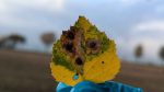
Mine Comment: The larvae form a distinctive leaf mine in the leaves of birch, beginning as a dark circular blotch, then extending to a larger pale blotch and frass in grains. Sometimes several mines in one leaf. The egg is laid on the underside of a leaf.
Kings Newton – 28/10/2024 – Tom Shields© / Buxton – Steve Orridge© / Glossop 25/10/2025 & 24/11/2025 – Christian Heintzen©


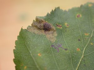


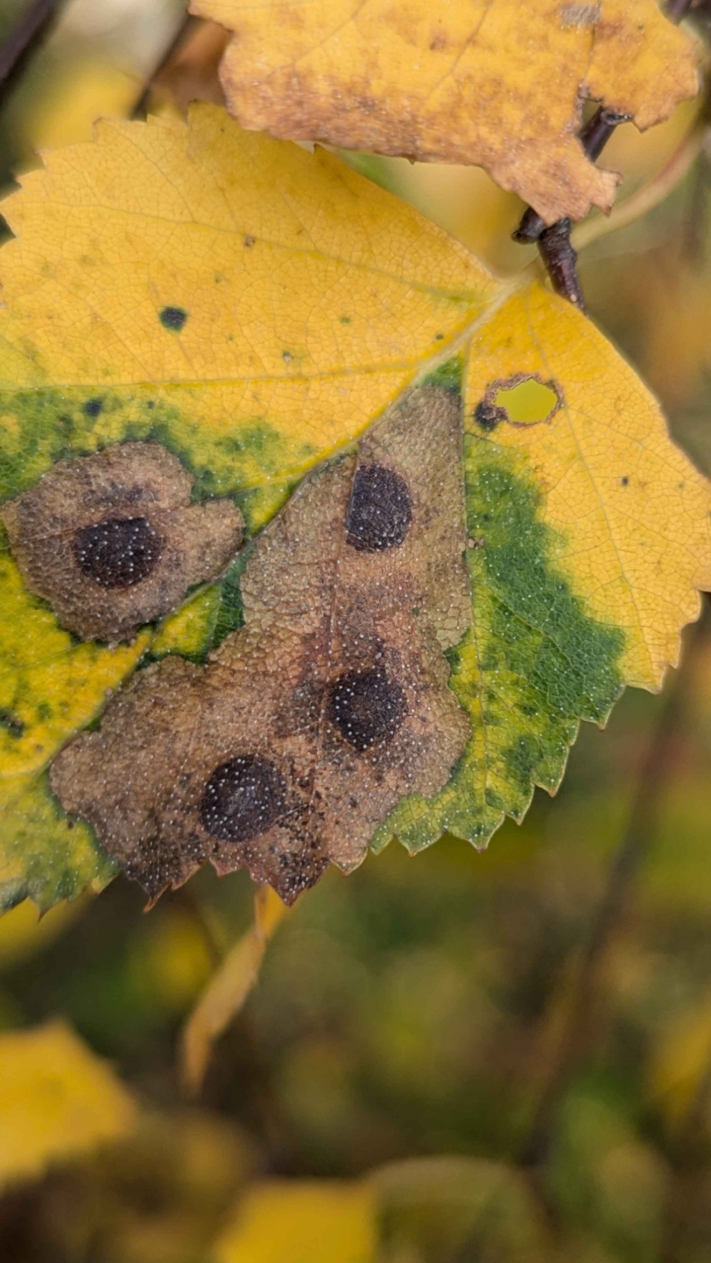

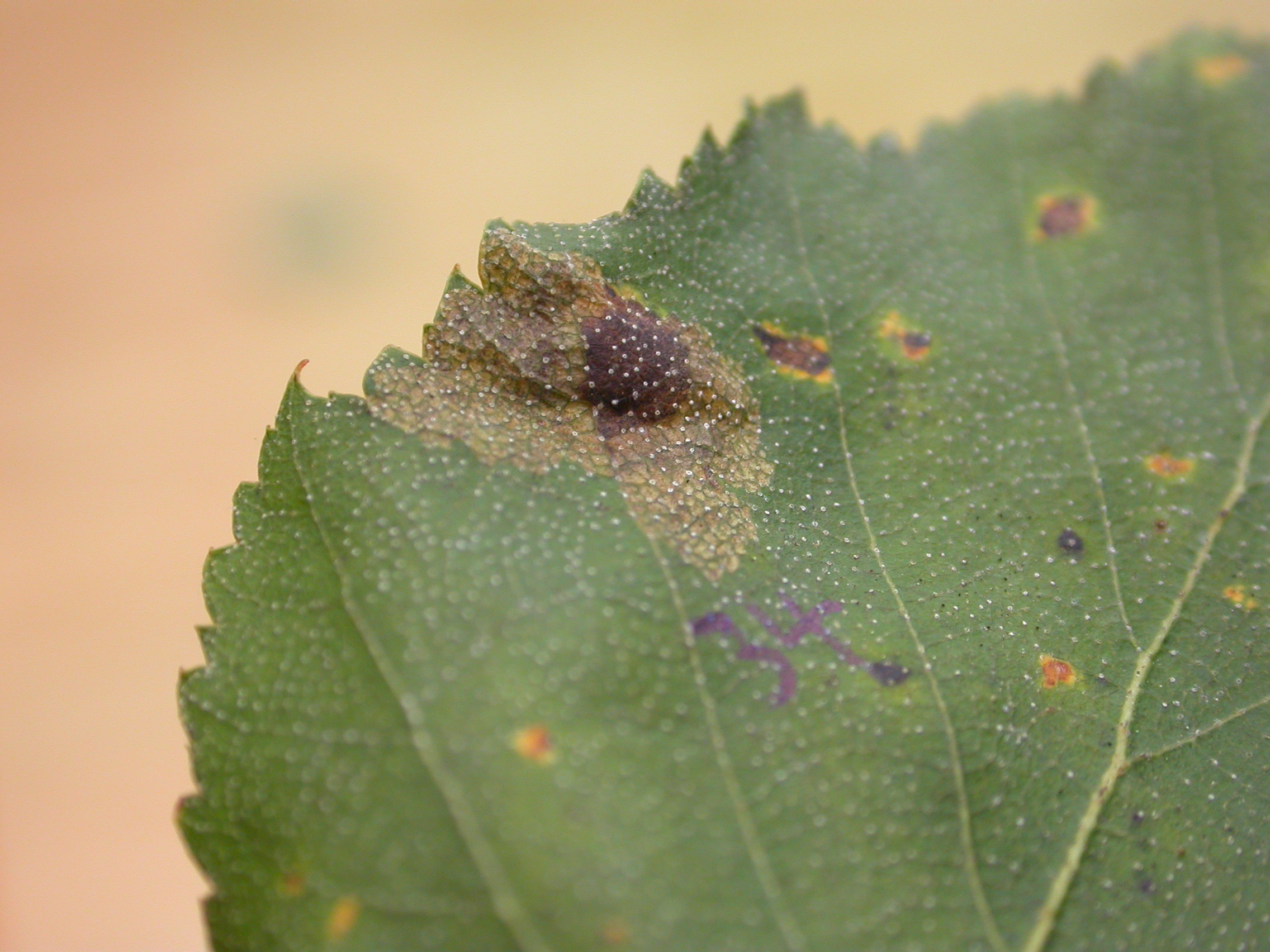


Image Gallery


Temporal Distribution Chart
Immatures: (between 2001 - 2025)
Distribution Map for Ectoedemia occultella
↳ from 2026+
↳ 6 from 2020 - 2025
↳ 17 from Before 2020
If the Map Layers function fails, just refresh the page and it should be OK after. Use the +- zoom on the top left, or on a tablet, use two fingers to zoom. Remember, the last layer you ticked is the one which displays the popup information - they sit on top of each other - de-select then re-select, to see the popup values.
Bedrock Geology ** indirectly affects moth distribution by influencing the type of habitat and food plants available in an area. In turn, this may affect the types of moths that can thrive, or where they can most likely be found.
NBN Atlas UK Distribution for – Ectoedemia occultella
⚠️ Please wait for the map to load fully – do not click the link shown.
Note – the NBN Atlas datasets are listed in the map below and vary in their currency (uptodateness) – however,
the map does give a general indication of the moth's distribution across the UK.
Monthly Records By Year:
Ectoedemia occultella
( data includes both Larvae and Adult Stages )
Monthly Counts By Year:
Ectoedemia occultella
( data is based on 'Adult' stage records only )
First/Last Recorded Dates: Ectoedemia occultella
Adult-only & Anything [Larvae, Pupae, Adult, Mines]
Shading shows moth presence between dates
Click the colour discs below to Select/De-select as Required
Recordings By Year: Ectoedemia occultella
( All data includes both Larvae and Adult Stages )
Annual Growth Rate (AGR): Ectoedemia occultella
AGR: 13.57% | Total % Change: 2020%
Hectad (10kmx10km) Coverage: Ectoedemia occultella
( data includes both Larvae and Adult Stages )
Flight Periods – Indicative –vs– Recorded Data
Ectoedemia occultella
Ectoedemia occultella
Flight Period chart – the grey hatched area above, which can cross one or more months, pictorially represents the best guess we have for this moth's flight periods [month/s]. The coloured lines represent the actual months seen in flight, from site observation records received between 2020-2026.
Mine Periods – Indicative –vs– Recorded Data
Ectoedemia occultella
Ectoedemia occultella
( data includes both Larvae and Adult Stages )
Mine Period chart – the grey hatched area above, which can cross one or more months, pictorially represents the best guess we have for this moth's mine periods [month/s]. The coloured lines represent the actual months seen mining, from site observation records received between 2020-2026.
Records Behind the Map and Charts - Ectoedemia occultella – 23 records available
Listed by Year - descending - scroll across to see all table columns
| Site Name | Tetrad | Date | Count | Stage | Recorder | Source | RecordKey |
|---|---|---|---|---|---|---|---|
| Glossop, Gnat Hole | SK09G | 24/11/2025 | 3 | Leaf-mine | Heintzen, Christian | vc57_irecords_extract | iBRC47521400 |
| Glossop, Shawmoor Plantation | SK09F | 25/10/2025 | 1 | Leaf-mine | Heintzen, Christian | vc57_irecords_extract | iBRC47521374 |
| Glossop, Gnat Hole | SK09G | 17/10/2025 | 1 | Leaf-mine | Heintzen, Christian | vc57_irecords_extract | iBRC47521367 |
| Harry's Wood, Smisby | SK32K | 13/10/2025 | 1 | Mine | Finch, Graham Leonard | vc57_irecords_extract | iBRC50351986 |
| Markham Vale, Hall Lane Pond | SK47H | 05/10/2025 | 100 | mine | Radford, Mark | vc57_irecords_extract | iBRC45797696 |
| King's Newton | SK32Y | 28/10/2024 | 10 | mine | TOM SHIELDS | vc57_irecords_extract | iBRC39158601 |
| Grange Wood | SK21S | 13/09/2018 | 1 | Mine | Finch, Graham Leonard | vc57_irecords_extract | iBRC35106431 |
| River Derwent, Hope Valley, England, GB | SK18U | 16/10/2011 | 1 | Larva | Dave Shenton | vc57_irecords_extract | iBRC39252529 |
| Millers Dale | SK17G | 03/09/2011 | 1 | Larval Mine | S.H. Hind | vc57_danes_bc_data | LC000334001CP7LC |
| Ladybower Resr | SK18U | 03/09/2010 | 1 | Larval Mine | S.H. Hind | vc57_danes_bc_data | LC000334001COXJB |
| Howden Resr | SK19L | 25/08/2010 | 1 | Larval Mine | S.H. Hind | vc57_danes_bc_data | LC000334001CP08V |
| Howden Resr | SK19S | 25/08/2010 | 1 | Larval Mine | S.H. Hind | vc57_danes_bc_data | LC000334001COXHS |
| Slippery Stones,Upper Derwent | SK19S | 25/08/2010 | 1 | Larval Mine | S.H. Hind | vc57_danes_bc_data | LC000334001COXI6 |
| Padley Gorge, Nether Padley | SK27P | 19/08/2010 | 1 | Larval Mine | S.H. Hind | vc57_danes_bc_data | LC000334001CP6HL |
| Linacre Wood | SK37G | 13/10/2009 | 1 | Larval Mine | S.H. Hind | vc57_danes_bc_data | LC000334001COWZU |
| Hope | SK18R | 07/10/2009 | 1 | Larval Mine | S.H. Hind | vc57_danes_bc_data | LC000334001COSZ9 |
| Norbury | SK14G | 02/10/2009 | 1 | Larva | Orridge, Steve | vc57_irecords_extract | iBRC38850710 |
| Norbury | SK14G | 01/10/2009 | 1 | Larval Mine | Dave Budworth;S.A. Orridge;S.H. Hind | vc57_danes_bc_data | LC000334001CP538 |
| Castleton | SK18L | 10/09/2009 | 1 | Larval Mine | S.H. Hind | vc57_danes_bc_data | LC000334001COWX0 |
| Calke Park | SK32L | 25/10/2008 | 1 | Mine | Finch, Graham Leonard | vc57_irecords_extract | iBRC35105475 |
| Calke Park,Ticknall | SK32R | 25/10/2008 | 1 | Larval Mine | VC57 Derbyshire Recorder | vc57_danes_bc_data | LC000334001COSOC |
| Brackley Gate, nr Coxbench | SK34W | 03/11/2001 | 1 | Larval Mine | S.H. Hind | vc57_danes_bc_data | LC000334001CP1FK |
| Cubley, nr Ashbourne | SK13U | 04/10/2001 | 1 | Larval Mine | S.H. Hind | vc57_danes_bc_data | LC000334001CP1F2 |