
 Leaf-miner: CAT L – The leaf or a Photo required –
  Larval Case: C1 – Distinctive Species –
  – click for General Verification Guidelines | – click for Specific Verification Guidelines
  – Generally Common / Widespread
  – Leaf-miner
Mine Period Additional: Leaf-mines can be discovered from June into August .
Mine ID Difficulty:
Mine Type/s: Gallery
Mine Feeding Method/s: Not Recorded
Mine Comment: The mine is a long, slender, often angular and distinctive gallery, created on the underside of the leaf. The frass forms a black central line, which is continuous, narrow and black running down the centre of the mine for its entire length. The mines are found on Betula (Birch). The mine of S.confusella differs from the similar species S.lapponica where the early part of the mine is filled with green, cloudy frass.
Blue-coded] moths is not displayed/updated in this tab. However, all verified records for this moth are listed in the RECORDS tab below. 
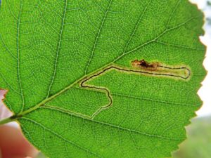

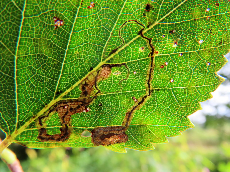

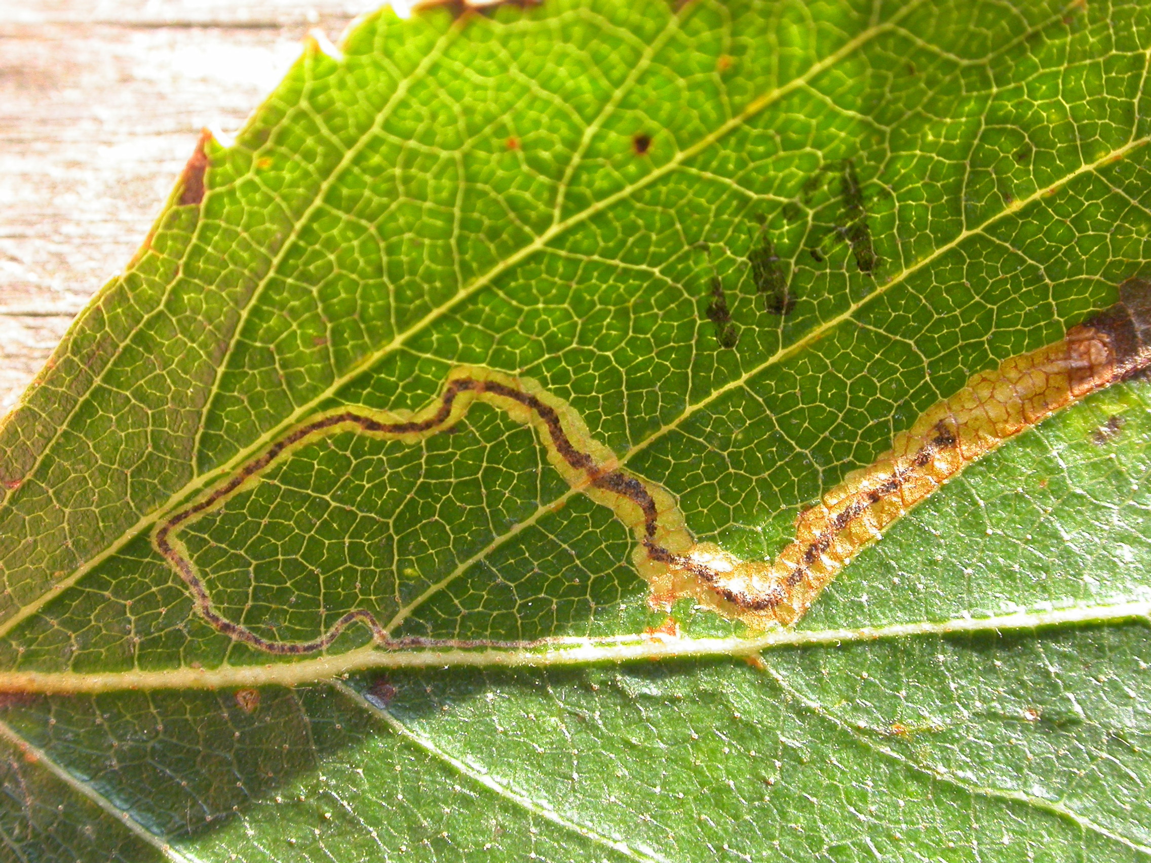
Image Gallery


Temporal Distribution Chart
Immatures: (between 2001 - 2025)
Distribution Map for Stigmella confusella
↳ from 2026+
↳ 8 from 2020 - 2025
↳ 15 from Before 2020
If the Map Layers function fails, just refresh the page and it should be OK after. Use the +- zoom on the top left, or on a tablet, use two fingers to zoom. Remember, the last layer you ticked is the one which displays the popup information - they sit on top of each other - de-select then re-select, to see the popup values.
Bedrock Geology ** indirectly affects moth distribution by influencing the type of habitat and food plants available in an area. In turn, this may affect the types of moths that can thrive, or where they can most likely be found.
NBN Atlas UK Distribution for – Stigmella confusella
⚠️ Please wait for the map to load fully – do not click the link shown.
Note – the NBN Atlas datasets are listed in the map below and vary in their currency (uptodateness) – however,
the map does give a general indication of the moth's distribution across the UK.
Monthly Records By Year:
Stigmella confusella
( data includes both Larvae and Adult Stages )
Monthly Counts By Year:
Stigmella confusella
( data is based on 'Adult' stage records only )
First/Last Recorded Dates: Stigmella confusella
Adult-only & Anything [Larvae, Pupae, Adult, Mines]
Shading shows moth presence between dates
Click the colour discs below to Select/De-select as Required
Recordings By Year: Stigmella confusella
( All data includes both Larvae and Adult Stages )
Annual Growth Rate (AGR): Stigmella confusella
AGR: 4.38% | Total % Change: 180%
Hectad (10kmx10km) Coverage: Stigmella confusella
( data includes both Larvae and Adult Stages )
Flight Periods – Indicative –vs– Recorded Data
Stigmella confusella
Stigmella confusella
Flight Period chart – the grey hatched area above, which can cross one or more months, pictorially represents the best guess we have for this moth's flight periods [month/s]. The coloured lines represent the actual months seen in flight, from site observation records received between 2020-2026.
Mine Periods – Indicative –vs– Recorded Data
Stigmella confusella
Stigmella confusella
( data includes both Larvae and Adult Stages )
Mine Period chart – the grey hatched area above, which can cross one or more months, pictorially represents the best guess we have for this moth's mine periods [month/s]. The coloured lines represent the actual months seen mining, from site observation records received between 2020-2026.
Records Behind the Map and Charts - Stigmella confusella – 23 records available
Listed by Year - descending - scroll across to see all table columns
| Site Name | Tetrad | Date | Count | Stage | Recorder | Source | RecordKey |
|---|---|---|---|---|---|---|---|
| Darwin Forest | SK36C | 06/10/2025 | 1 | mine (empty) | Evans, Dave | vc57_irecords_extract | iBRC45819790 |
| DWT Wyver Lane | SK34P | 02/09/2025 | 5 | mine (empty) | Evans, Dave | vc57_irecords_extract | iBRC45019764 |
| DWT Wyver Lane | SK34P | 13/08/2025 | 3 | mine (empty) | Evans, Dave | vc57_irecords_extract | iBRC44440749 |
| DWT Wyver Lane | SK34P | 06/08/2025 | 4 | mine (empty) | Evans, Dave | vc57_irecords_extract | iBRC44213441 |
| DWT Wyver Lane | SK34P | 23/07/2025 | 1 | mine (empty) | Evans, Dave | vc57_irecords_extract | iBRC43746924 |
| Monsall Trail | SK17R | 14/10/2024 | 1 | mine (empty) | Harvey, Martin C. | vc57_irecords_extract | iBRC38898617 |
| DWT Wyver Lane | SK34P | 12/09/2024 | 6 | mine (empty) | Evans, Dave | vc57_irecords_extract | iBRC38431862 |
| DWT Wyver Lane | SK34P | 04/09/2024 | 10 | mine (empty) | Evans, Dave | vc57_irecords_extract | iBRC38312552 |
| Blacka Moor and Plantation | SK28V | 27/06/2015 | 2 | Larva | Watchorn, Andrew | vc57_irecords_extract | iBRC6215708 |
| Millers Dale | SK17G | 03/09/2011 | 1 | Larval Mine | S.H. Hind | vc57_danes_bc_data | LC000334001COU5G |
| Thorpe, Ashbourne DE, UK | SK15K | 13/10/2010 | 1 | Larva | Orridge, Steve | vc57_irecords_extract | iBRC45128483 |
| Thorpe, Dovedale | SK15K | 13/10/2010 | 1 | Larval Mine | S.A. Orridge;S.H. Hind | vc57_danes_bc_data | LC000334001COTQS |
| Ladybower Resr | SK18U | 03/09/2010 | 1 | Larval Mine | S.H. Hind | vc57_danes_bc_data | LC000334001COXIP |
| Howden Resr | SK19L | 25/08/2010 | 1 | Larval Mine | S.H. Hind | vc57_danes_bc_data | LC000334001CP099 |
| Howden Resr | SK19S | 25/08/2010 | 1 | Larval Mine | S.H. Hind | vc57_danes_bc_data | LC000334001COXHZ |
| Slippery Stones,Upper Derwent | SK19S | 25/08/2010 | 1 | Larval Mine | S.H. Hind | vc57_danes_bc_data | LC000334001COXII |
| Padley Gorge, Nether Padley | SK27P | 19/08/2010 | 1 | Larval Mine | S.H. Hind | vc57_danes_bc_data | LC000334001COXGU |
| Linacre | SK37G | 13/10/2009 | 1 | Larval Mine | S.H. Hind | vc57_danes_bc_data | LC000334001COWZX |
| Monsall Trail, Buxton | SK17L | 14/09/2008 | 1 | Larval Mine | S.H. Hind | vc57_danes_bc_data | LC000334001COSNV |
| Mousley Bottom, New Mills | SJ98X | 03/09/2007 | 1 | Larval Mine | S.H. Hind | vc57_danes_bc_data | LC000334001CP44U |
| Shallcross Wood, Goyt Valley, Whaley Bridge | SK07E | 26/09/2006 | 1 | Larval Mine | S.H. Hind | vc57_danes_bc_data | LC000334001CP9YH |
| Clattercotes Wood, nr Ogston Resr | SK36Q | 12/07/2006 | 1 | Larval Mine | S.H. Hind | vc57_danes_bc_data | LC000334001CORT0 |
| Brackley Gate, nr Coxbench | SK34W | 03/11/2001 | 1 | Larval Mine | S.H. Hind | vc57_danes_bc_data | LC000334001COR0I |